Keal Run in Indiana County’s Banks Township is one of Pennsylvania’s most authentic ghost town experiences—a coal camp that rose and vanished within a single generation. Before you go, study the 1914 mining map and cross-reference LIDAR imagery to spot collapsed mine entrances beneath the forest canopy. Access the site legally through State Game Lands 174 via Sidney and Lochvale Roads. Everything you need to plan a rewarding, responsible visit is waiting just ahead.
Key Takeaways
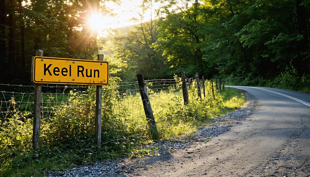
- Keal Run, located in Banks Township, Indiana County, Pennsylvania, is accessible via Sidney and Lochvale Roads, with their intersection serving as a key landmark.
- State Game Lands 174 borders the area and provides legal public access for exploring the ghost town remnants responsibly.
- Study the 1914 Mining Map and 1939 Aerial View before visiting to identify former structures, mine waste dumps, and drift locations.
- LIDAR imagery reveals collapsed mine entrances, faint road traces, and ground disturbances that help define the ghost town’s boundaries.
- Nearby ghost towns like Wehrum, Bracken, and Armerford, plus the Ghost Town Trail, make ideal stops for a fuller road trip.
What Makes Keal Run Worth the Drive?
Few ghost towns in Pennsylvania reward the curious traveler quite like Keel Run — a coal mining settlement tucked into Banks Township, Indiana County, that’s virtually erased from the landscape yet rich with layered history.
Keel Run’s significance lies in what it represents: a community that rose, served its industrial purpose, and quietly vanished. You’re not just visiting an empty field — you’re standing inside a historical context that stretches from early logging operations through the coal boom of the early 1900s.
A community that rose, served its purpose, and vanished — leaving only history where a town once stood.
LIDAR imagery still reveals collapsed mine entrances, and period maps trace the community’s short but telling arc.
For travelers who crave authentic discovery over manufactured tourism, Keel Run delivers something rare — a place where you piece together the story yourself.
Read These Maps Before You Hit the Road
Before you hit the road, pull up the 1906, 1914, and 1939 historical maps to watch Keal Run transform from a logging settlement into a coal mining community, complete with drifts, a railroad station, and mine waste dumps.
Layer in LIDAR data and you’ll spot the collapsed #1 Drift mine entrance north of the village, terrain details no standard map can show you.
Use the intersection of Sidney and Lochvale Roads as your visual anchor across all three map periods to lock in your route before you ever leave the driveway.
Historic Map Overview
Three historic maps serve as your essential guide before hitting the road to Keel Run and Sidney — each one revealing a different layer of these ghost towns’ evolution.
Together, they build a compelling historic context around the region’s mining legacy:
- 1906 Topographic Map — Shows Sidney with a single school building, zero evidence of Keal Run, and no connecting road. This is your baseline.
- 1914 Mining Map — Introduces two drifts, a village cluster, railroad station, and school, capturing the coal boom’s peak expansion.
- 1939 Aerial View — Exposes Keal Run’s houses, a mine waste dump, and a path to the portal, while Sidney’s structures have already vanished.
Study these maps in sequence — you’ll understand exactly what you’re chasing before you arrive.
LIDAR Terrain Insights
Where the 1939 aerial leaves off, LIDAR picks up — and what it reveals beneath the tree canopy will sharpen your expectations before you ever turn onto Sidney Road.
Through terrain analysis, you’ll spot what decades of forest growth have hidden: a collapsed mine entrance north of the village, clearly visible as a surface depression in the LIDAR-rendered landscape.
LIDAR applications strip away the vegetation digitally, exposing subtle ground disturbances that confirm where mining activity once shaped this hollow.
You’re not guessing at ghost town boundaries anymore — you’re reading the earth itself.
Pull up a LIDAR viewer before you leave home, cross-reference it against your 1914 mining map, and you’ll arrive knowing exactly what you’re looking for on the ground.
Route Visualization Tips
Pulling up the right maps before you hit the road transforms a vague drive into a focused expedition.
Layer your route planning with these three essential mapping techniques:
- Compare the 1906 and 1914 historical maps — spot how Sidney’s single schoolhouse evolved into a full mining settlement with two drifts, a village cluster, and a railroad station.
- Overlay the 1939 aerial imagery — you’ll immediately see which structures vanished and where Keal Run’s waste dump and mine portal path once stood.
- Run LIDAR against modern satellite views — collapsed drift entrances invisible to standard maps suddenly appear as clear terrain depressions along Sidney and Lochvale Roads.
Cross-referencing all three layers gives you confident, purposeful navigation.
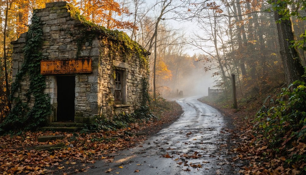
How to Get to Keal Run in Indiana County, Pennsylvania?
Tucked within Banks Township, Indiana County, Pennsylvania, Keal Run isn’t the easiest place to find, but that’s part of its ghostly charm.
You’ll navigate access routes along Sidney and Lochvale Roads, where their intersection serves as your primary landmark. From there, you’re stepping into a place of deep historical significance — a coal mining settlement that thrived in the early 1900s before fading into obscurity.
Use LIDAR maps and historical overlays to orient yourself before arriving, since physical markers are scarce.
State Game Lands 174 borders the area, offering a recognizable reference point. Keep private property boundaries in mind, as much of the surrounding land restricts public entry.
Aerial imagery and topographic maps remain your best tools for confidently exploring this forgotten Indiana County ghost town.
What Can You Still See at Keal Run Today?
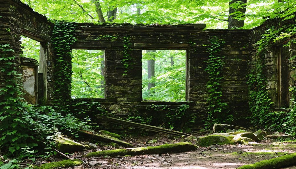
Though little survives above ground, Keal Run still rewards the careful observer. Armed with LIDAR maps and aerial imagery, you’ll spot fascinating Keal Run remnants that tell a raw story of mining history.
Here’s what you can still detect:
- Collapsed mine entrance – LIDAR reveals the sunken #1 Drift portal north of the village, a ghostly scar on the landscape.
- Mine waste dump – Visible in 1939 aerial photos, this spoil heap remains a physical marker of coal extraction’s environmental footprint.
- Trace road paths – Faint routes once connecting workers to the portal still appear on historical overlays.
Cross-reference old maps with current satellite views, and you’ll reconstruct Keal Run’s working-class past with surprising clarity.
Why Did Keal Run’s Coal Economy Collapse So Completely?
When you stand at the edge of what was once Keal Run, you’re looking at the aftermath of a collapse that hit fast and hit hard.
Coal demand dropped sharply in the mid-twentieth century as railroads switched to diesel and homes converted to oil and gas heat, gutting the market that had kept small operations like this one alive.
The mining infrastructure here — narrow drifts, short rail spurs, and modest room-and-pillar workings — couldn’t adapt to modern mechanized extraction, making abandonment the only practical outcome.
Coal Demand Collapsed Rapidly
The coal economy that once sustained Keal Run didn’t collapse slowly — it cratered. Coal market fluctuations hit small operations hardest, and the mining industry decline swept through communities like this one with brutal efficiency.
Three forces accelerated the collapse:
- Cheaper energy alternatives — Oil and natural gas undercut coal’s dominance, shrinking demand almost overnight.
- Exhausted seams — Smaller drift mines couldn’t compete once accessible coal ran thin.
- Railroad abandonment — Without rail connections, transporting remaining coal became economically impossible.
You’re looking at a town that had no fallback plan. When the market shifted, workers left, houses emptied, and the forest reclaimed everything.
Understanding these pressures helps you appreciate what you’re actually walking into when you explore Keal Run’s remnants today.
Mining Infrastructure Became Obsolete
Cheap energy alternatives and exhausted seams dealt Keal Run a punishing blow, but they didn’t finish the town alone — obsolete infrastructure sealed its fate.
The railroad spurs, drift entrances, and room-and-pillar workings you’d find documented on 1914 mining maps weren’t adaptable to modern extraction methods. When equipment costs outpaced coal revenues, operators simply walked away, leaving abandoned infrastructure to collapse under its own weight.
LIDAR imagery today reveals those caved drift entrances north of the village — silent evidence of a mining legacy nobody bothered to dismantle. The waste dumps and acid drainage scars along West Branch of Bear Run tell the same story.
Once the machinery stopped paying for itself, Keal Run’s economic foundation didn’t just weaken — it vanished entirely.
Other Ghost Towns Near Keal Run Worth Adding to Your Route
Once you’ve soaked in the eerie stillness of Keal Run, Indiana County’s Ghost Town Trail opens up a compelling string of coal-era ruins worth weaving into your route.
These abandoned structures tell the same brutal story of boom-and-bust mining history across Western Pennsylvania:
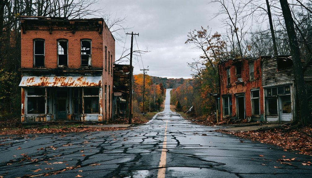
- Wehrum – Once boasting 230 houses, a hotel, company store, and jail, this town peaked under Warren Delano’s development before disappearing entirely.
- Bracken and Armerford – Smaller settlements that quietly vanished alongside the collapsing coal economy, leaving only traces behind.
- Lackawanna #3 and Claghorn – Former mining communities where foundations and landscape scars remain readable if you know what you’re looking for.
Most sites sit on private property, so respect boundaries and rely on maps before you go.
Which Ghost Town Trail Sites Are Worth the Detour From Keal Run?
If you’re already exploring Keal Run, the Ghost Town Trail in Indiana County makes for a compelling detour, offering remnants of Wehrum, Bracken, Armerford, and several other coal-era settlements along a single corridor.
Wehrum stands out as the crown jewel, once boasting 230 houses, a hotel, company store, jail, and bank before vanishing into the forest.
Keep in mind, though, that most Ghost Town Trail sites sit on private property, so you’ll want to confirm access restrictions before you leave the pavement behind.
Wehrum’s Remarkable Ghost Town
Wehrum stands out as the crown jewel among Indiana County’s Ghost Town Trail sites, and it’s worth every mile of the detour from Keel Run. Wehrum history reveals a once-thriving mining community developed by Warren Delano, boasting extraordinary ghost town significance across its peak infrastructure:
- 230 houses once sheltered a bustling workforce deep in Pennsylvania coal country.
- A hotel, company store, and bank defined Wehrum as a self-contained industrial village.
- A jail reinforced the town’s surprising scale and organizational complexity.
Today, you’ll explore atmospheric remnants that whisper stories of boom-and-bust Appalachian coal culture.
Unlike Sidney and Keal Run, Wehrum delivers tangible, discoverable history along accessible trail corridors. It’s the kind of place that rewards curious, independent explorers craving authentic American industrial heritage.
Ghost Town Trail Highlights
Beyond Wehrum’s storied ruins, the Ghost Town Trail corridor rewards detour-worthy stops at Bracken, Armerford, Lackawanna #3, Scott Glenn, Webster, Beulah, and Claghorn — each a collapsed chapter of Western Pennsylvania’s coal boom etched into the Appalachian landscape.
You’ll find authentic ghost town experiences scattered across this trail, where coke oven remains, crumbled foundations, and reclaimed earth tell mining history without a museum’s filter.
Most sites sit on private property, so you’ll want to check boundaries carefully before exploring.
Pair your Keal Run visit with a drive along the Ghost Town Trail corridor to connect these vanished communities into a single, cohesive narrative.
The landscape itself becomes your guide, revealing how completely a booming coal economy can rise, collapse, and quietly disappear into the Pennsylvania hills.
Private Property Access Limits
Private property boundaries define your Ghost Town Trail experience more than any map will warn you upfront. Most sites sit on restricted land, so you’ll need to plan smart before heading out.
Here’s what you should know about access challenges:
- Wehrum offers the most dramatic remnants—230 house foundations, a company store, jail—but confirm current access before walking in.
- Bracken and Armerford sit deep within private property corridors, making roadside viewing your safest bet.
- Lackawanna #3 and Webster require checking Indiana County trail authority updates, as permitted access shifts seasonally.
Your freedom here depends on respecting boundaries.
Combine publicly accessible segments with State Game Lands 174 trails near Keal Run, and you’ll still piece together a genuinely rewarding coal country experience.
What Can You Do at State Game Lands 174 While You’re There?
State Game Lands 174 wraps around the Sidney and Keal Run area, giving you a natural complement to the ghost town exploration.
You’ll find horse riding trails cutting through the landscape, letting you cover more ground than on foot. The terrain shifts from open ridgelines to dense woodland, making wildlife observation genuinely rewarding — deer, wild turkey, and black bear move freely through this corridor.
Hikers can follow hiking trails that trace the same ridges early miners once crossed daily. You’re moving through land that’s reclaimed itself after decades of industrial use, and that contrast between extraction and recovery makes every step more meaningful.
No admission fees, no crowds — just open land and the freedom to explore it on your own terms.
How to Visit Keal Run Without Trespassing
Visiting Keel Run responsibly means working with what’s publicly accessible rather than pushing past boundaries that aren’t yours to cross.
Sustainable tourism keeps these forgotten places discoverable for future explorers.
- Use State Game Lands 174 – The horse riding trails legally place you near both Sidney and Keal Run markers without crossing private property lines.
- Study maps before arriving – The 1906, 1914, and 1939 historical maps plus LIDAR imagery reveal collapsed mine entrances and local history details you can reference from public roads.
- Stay on Sidney and Lochvale Roads – These intersections offer legitimate vantage points for observing terrain shifts from logging to coal country.
Respect boundaries, carry your maps, and let the landscape tell its story on its own terms.
How to Build a Longer Coal Region Trip With Keal Run as Your Base
Once you’ve explored Keal Run’s collapsed mine entrances and logged a few miles on State Game Lands 174’s horse trails, you’re already positioned to push deeper into Indiana County’s coal ghost town corridor.
Head toward the Ghost Town Trail, where Wehrum, Bracken, and Armerford offer serious ghost town photography opportunities among coke oven ruins and company store foundations. Wehrum alone peaked at 230 houses before disappearing entirely.
Wehrum once held 230 houses. Today, the Ghost Town Trail offers coke oven ruins and company store foundations in their place.
If you’re committed to historical preservation, cross-reference 1914 mining maps against what’s still standing.
Extend your itinerary southwest toward Centralia, where a 1962 underground fire emptied an entire borough. Each stop layers another chapter of Appalachian coal’s collapse.
You’re not just driving between coordinates — you’re tracing an economic and human story that Pennsylvania’s landscape refuses to fully erase.
Frequently Asked Questions
Are There Guided Tours Available for Keal Run or Nearby Ghost Towns?
Guided ghost town history tours aren’t officially available, but you’ll find freedom exploring State Game Lands 174’s trails nearby. Seek out local legends yourself along the Ghost Town Trail, uncovering Wehrum’s weathered, whispering remnants independently.
What Is the Best Time of Year to Visit Keal Run?
Late spring and fall offer you the best seasonal attractions at Keal Run! You’ll enjoy mild weather considerations, clearer sightlines through bare trees, and comfortable hiking across State Game Lands 174’s trails without summer’s dense foliage blocking historical remnants.
Is Keal Run Suitable for Children or Elderly Visitors?
Keal Run’s rugged terrain limits accessibility options for elderly visitors, but it’s an adventurous spot for curious children. You’ll enjoy family activities on nearby State Game Lands 174 trails, offering a more accessible outdoor experience.
Are There Any Accommodations Near Keal Run for Overnight Stays?
With over 50% of Ghost Town Trail sites on private land, you’ll find accommodations in nearby Indiana County towns. They offer local dining options and let you fully absorb Keal Run’s rich historical significance during your overnight stay.
What Photography Equipment Is Recommended for Documenting Ghost Town Remnants?
Bring a wide-angle lens and tripod to capture abandoned structures with stunning clarity. You’ll master photographic techniques using HDR settings and a drone, revealing Keal Run’s haunting beauty from perspectives that’ll ignite your adventurous spirit.
References
- https://ironequine.com/history-bits/history-of-sidney-keal-run-lochvale-pennsylvania/
- https://en.wikipedia.org/wiki/List_of_ghost_towns_in_Pennsylvania
- https://www.youtube.com/watch?v=Qj5LjacccJ0
- https://uncoveringpa.com/visiting-centralia
- https://www.youtube.com/watch?v=J93tAO-98Mo
- https://indianacountyparks.org/our-trails/ghost-town-trail/ghost-town-trail-history/


