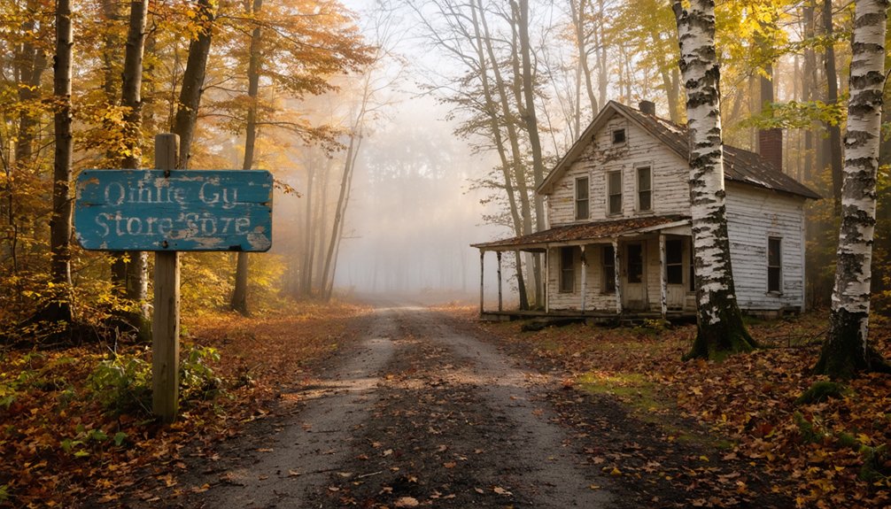
You’ll find Kelly Stand Road winding through Vermont’s Green Mountains, where a 15-room hotel once welcomed loggers and stagecoach travelers for $2.50 a night before the forest reclaimed it entirely. Start your ghost town expedition from East Arlington via Kansas Road, stopping at the Daniel Webster monument marker before continuing to Grout Pond’s logging camp ruins—look for hand-stacked stone piers and weathered chimneys hidden among the trees. The unpaved western section gets muddy after rain, so pack boots and explore the foundations that whisper stories of fiddles echoing from third-floor ballrooms.
Key Takeaways
- Kelly Stand Road traverses Vermont’s Green Mountains, connecting East Arlington and Stratton through historic logging territory and vanished 1840s hotel sites.
- Access via Route 7A through East Arlington or Route 100 at West Wardsboro; road climbs 2,200 feet over 10 miles.
- Visit Daniel Webster monument marker, Grout Pond’s 2.7-mile loop trail, and 19th-century logging camp ruins with stone foundations.
- Western road sections unmaintained with mud after rain; 35mm tires suitable for bumpy conditions and recent stone additions.
- Overnight parking available at Appalachian Trail intersection; verify wilderness camping policies and access regulations before visiting.
The History Behind Kelly Stand Road and Its Vanished Inn
Deep in Vermont’s Green Mountains, Kelley Stand Road winds through territory where commerce once thrived and travelers sought refuge from unforgiving weather. You’ll find the former inn’s architectural features have vanished—bulldozed around 1950—but local folklore about establishment persists among longtime residents who remember tales of trout dinners and Washington’s Birthday balls.
The Kelley family transformed their 1840s homestead into a fifteen-room hotel serving loggers and stagecoach travelers. For $2.50, you’d get a meal, room, and horse care while traversing this remote plateau. The inn’s third-floor ballroom once echoed with fiddles and dancing boots.
Today, the side road leading to the site is nearly invisible, reclaimed by forest. You’re free to explore this ghost town remnant, where only the road name honors the enterprising family who carved civilization from wilderness.
Finding the Daniel Webster Speech Site and Historical Marker
While most historical markers sit prominently beside paved highways, the Daniel Webster monument hides along a dirt track where few casual drivers venture. You’ll find this metal plaque mounted on a large rock, positioned partway up an unmarked driveway just hundreds of yards east of the Stratton Pond Trail trailhead.
This forgotten monument sits hidden on a rough dirt road, far from the polished historical markers that line America’s highways.
Locating this obscure memorial rewards your adventurous spirit:
- Navigate Kelly Stand Road between East Arlington and Stratton
- Watch for the rock marker near the Stratton-Sunderland boundary
- Access via Route 7A through East Arlington Road and Kansas Road
- Alternatively approach from Route 100 at West Wardsboro
- Park respectfully along the narrow forest road
Historians continue uncovering historic documents and verifying attendance estimates—sources claim between 1,600 and 15,000 gathered here in 1840, though Webster’s actual words remain unrecorded.
Exploring Grout Pond and Surrounding Mountain Scenery
Just beyond the Daniel Webster monument, Kelly Stand Road ascends onto a high plateau where Forest Road 262 branches off toward Grout Pond—an 84-acre gem cradled in mixed conifer and hardwood forest. You’ll navigate a twisty one-lane dirt road that rewards your persistence with stunning views of Stratton Mountain and Mount Snow from nearby trails.
The pond’s 28-foot depths reflect red spruce and yellow birch, especially spectacular during fall foliage season. Recreational opportunities abound year-round: paddle the 200-foot carry-in launch, fish the quiet waters, or tackle 10+ miles of multi-use trails radiating from camp. The relatively flat 2.7-mile Grout Pond Loop suits most abilities, though expect muddy patches.
Seasonal accessibility varies—Kelly Stand Road shifts from pavement to gravel, becoming challenging in shoulder seasons. Six waterfront campsites place you directly amid this backcountry solitude.
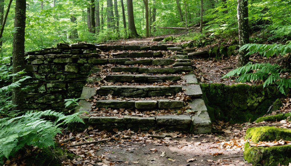
Tracing the Remnants of 19th Century Logging Camps
As you hike Kelly Stand Road’s forested corridors, watch for subtle depressions in the earth and scattered stone foundations—these are your breadcrumbs to a vanished world where 18 mills once thundered along Roaring Branch.
You’ll spot hand-stacked stone piers rising from the leaf litter, weathered chimneys standing sentinel among the birches, and century-old campfire pits that still hold their circular shape despite decades of neglect.
The forest has reclaimed what was once a denuded industrial landscape, but if you slow down and scan the undergrowth near old trail intersections, the ghosts of those logging camps reveal themselves through crumbling mortared rock and rusted metal fragments half-buried in moss.
Locating Former Camp Sites
The forest has swallowed most evidence of the bustling logging camps that once lined Kelly Stand Road, but persistent explorers can still trace their footprints. Start identifying specific camp ruins near Grout Pond, where the Grout family operation left scattered foundations. You’ll discover mapping trail networks between camps becomes easier when following old railbed depressions through second-growth forests.
Watch for these telltale signs:
- Stone piers and ceramic chimney liners marking cookhouse locations
- Twisted metal bedframes rusting beneath maple and birch canopy
- Overgrown side roads branching toward former hotel sites
- Depression trails where 41 miles of railroad track once connected operations
- Place names like Macintyre Job and Mill Pond indicating settlement points
The high plateau adjacent to Lye Brook Wilderness holds particularly concentrated remnants from two major camps.
Archaeological Evidence Along Route
Beyond identifying camp locations through landscape features, you’ll find the physical artifacts scattered throughout Kelly Stand Road tell their own stories.
Two miles north of Stratton Pond, massive brick piles reveal charcoal kiln archaeology—these industrial furnaces processed logged timber into fuel for 19th-century operations. You’ll spot limestone quarry remnants near old farms, where workers burned rock into powdered lime. Look for crushed chalky stones and limestone chunks protruding from overgrown fields, untouched for over a century.
The Lye Brook Railroad grade offers another archaeological treasure: wide serpentine curves and rotting log bridges crossing ravines. Each artifact—from foundation stones to factory remains—lets you piece together how logging communities transformed these mountains. Walk slowly, observe carefully, and you’ll read history written in stone and earth.
Logging Industry Historical Context
When you stand among the crumbling brick foundations scattered along Kelly Stand Road, you’re witnessing the skeletal remains of Vermont’s first industrial revolution. These camps sheltered independent loggers’ lifestyles during the mid-1800s boom, when Burlington ranked as America’s third-largest lumber port.
The history of Kelly Stand, Vermont reveals not just the rise of the logging industry but also the challenges faced by these early settlers. Weathered by harsh winters and the demands of their trade, they forged a resilient community that laid the groundwork for future generations. Today, remnants of their ingenuity remain, inviting new visitors to explore the tales etched into the landscape.
Winter operations: Loggers harvested timber during frozen months, then bound massive rafts for spring transport
Economic powerhouse: A single cord fetched $2.50-$5 at railway depots—serious money for rural workers
Resource depletion: By 1840, every quality tree in the Champlain Valley had vanished
Forced imports: Vermont eventually imported wood from other territories after exhausting local supplies
State intervention: Legislative forestry policies transformed depleted logging lands into protected state forests
You’ll find freedom in understanding how unrestrained extraction ultimately demanded conservation.
Winding through the Green Mountain National Forest, Kelley Stand Road traces a rugged path that logging crews carved more than a century ago to reach remote timber camps scattered across these highlands. You’ll climb 2,200 feet over ten miles from the valley floor, following Roaring Branch through a narrow canyon before cresting onto a high plateau.
The western section remains unmaintained during winter—expect mud after rainstorms and seasonal weather patterns that determine passability. Recent stone additions create a bumpy ride, but cross bikes with 35mm tires handle it at 70-80 psi.
You’ll find overnight parking where the Appalachian Trail intersects, perfect for accessing Stratton Pond or the mountain’s fire tower. Check wilderness access regulations before camping near century-old stone fire pits and abandoned logging remnants.
Locating the Bulldozed Inn Site and Overgrown Access Paths
Finding the Kelley Stand site demands detective work—you’ll search for subtle ground depressions, unnatural stone alignments, and the faint trace of that overgrown side road branching from the main route. Your smartphone’s GPS won’t pinpoint crumbling foundations hidden beneath decades of forest regrowth, so you’ll need to read the landscape itself: look for level clearings that seem too deliberate, old-growth trees forming suspicious property lines, and scattered fieldstone that once anchored walls.
Before you bushwhack into the understory, mark your entry point carefully and wear sturdy boots—the Forest Service’s boulder barriers prevent vehicle access for good reason, and getting disoriented among these lookalike forest corridors happens faster than you’d expect.
Reading Historical Landscape Clues
Though decades of forest regrowth have reclaimed the Kelly Stand Inn site, careful observation reveals subtle clues that distinguish this historical location from the surrounding wilderness. You’ll sharpen your skills in identifying historical artifacts and interpreting physical landscape markers as you explore:
- Stone foundations scattered across uneven terrain mark where the hotel’s walls once stood
- The tall smokestack piercing through tree canopy—your most prominent landmark
- Subtle terrain depressions indicating former building footprints and cleared areas
- Old metal work and brick fragments half-buried in forest floor debris
- Cleared patterns diverging from natural forest succession
Watch how the river runs alongside the road, providing geographic orientation. Winter visits offer clearer visibility than summer’s concealing foliage, letting you read the landscape’s story more easily.
Modern GPS Coordinates
Your smartphone becomes an invaluable navigation tool once you’ve learned to read the physical remnants scattered through the forest. Start with verified GPS coordinates at No Name Hole (Lat 43.05427, Lon -73.11656), located 0.25 miles from Kelly Stand Road’s Roaring Brook bridge turn. These measured GPS coordinates anchor your exploration of the bulldozed inn site, which sits somewhere along the road’s high plateau near where the Appalachian Trail crosses between mile points 1615-1625.
The overgrown access paths branch toward Stratton Pond shelter (north, AT mile 1625) and Story Spring shelter (south, AT mile 1615). Download Vermont-specific layers on the Outly mobile app for precise GPS overlay—essential since the western dirt section’s winter non-maintenance creates challenging navigation through twisting, unmarked terrain.
Safe Exploration Best Practices
Several overgrown turnoffs branch from Kelly Stand Road’s main corridor, but locating the bulldozed inn site demands patience and practiced observation—skills you’ll develop by training your eyes to spot unnatural terrain patterns beneath decades of forest reclamation.
Foundation depressions reveal themselves as subtle rectangular shadows in morning light, marking where the 1840s hotel once stood.
That tall smokestack requires structural integrity assessments before approaching—decades of Vermont weather have compromised its stability.
Stone alignments emerge through vegetation management strategies involving careful leaf clearing rather than aggressive cutting.
The river’s proximity serves as your primary navigation reference when overgrowth obscures the access path.
Metal framework remnants warn you’re entering the historical footprint—watch your footing around unstable components.
Document everything photographically while respecting the site’s fragile state.
Understanding the Appalachian Trail Connection
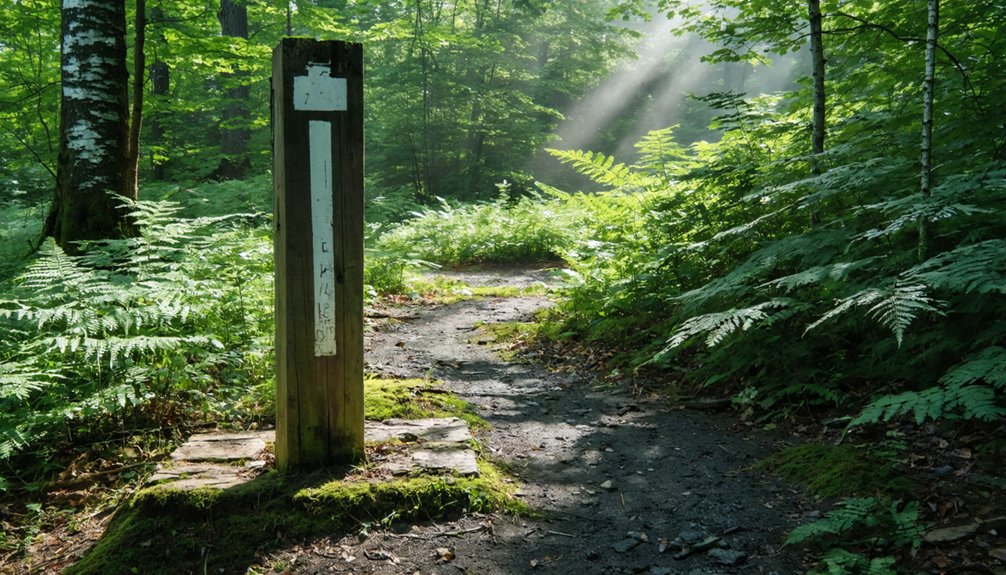
The white blazes of the Appalachian Trail cut straight across Kelley Stand Road at mile marker 1615, where hikers emerge from dense Green Mountain forest onto a dirt throughway that feels caught between wilderness and civilization.
You’re standing at one of the AT’s most historically significant trail junctions—Benton MacKaye conceived his vision for this legendary footpath somewhere near this very crossing. If you’re planning thru hiker logistics, Story Spring shelter sits just south while Stratton Pond awaits 10 miles north.
Park overnight at the trailhead and you’ll witness dawn departures of determined wanderers shouldering their lives into backpacks. The convergence of the Long Trail here creates a compass rose for those seeking elevation and escape. Follow those blazes—they’ve guided countless souls toward freedom.
Best Times to Visit and Essential Trip Preparations
Planning your journey to Kelly Stand means respecting the mountain’s temperament—this isn’t a road you can visit on a whim in February. Seasonal closure schedules dictate late spring through early fall access, when the Green Mountains finally shed their snow barriers. Tropical Storm Irene proved nature’s authority here, keeping this route locked down for four years until September 2014.
Your preparations determine everything:
- Vehicle readiness: High-clearance recommended for gravel stretches; pack spare tire and tools
- Navigation essentials: Download maps beforehand—cell service vanishes here
- Self-sufficiency supplies: Water, snacks, first-aid kit for isolated exploration
- Weather flexibility: Mountain conditions shift rapidly; layer your clothing
- Fuel strategy: Gas up completely before departure
Autumn offers spectacular scenic viewpoints during open season, with foliage painting the mountains before winter reclaims its throne.
Frequently Asked Questions
Are There Any Nearby Campgrounds or Lodging Options for Overnight Stays?
You’ll find Grout Pond Campground with reservable sites and a year-round hut, plus free dispersed camping along Forest Road 71. For comfort, check out rustic cabins nearby or local bed and breakfasts in Arlington and Stratton.
What Cell Phone Coverage Can Visitors Expect Along Kelly Stand Road?
You’ll encounter cell phone dead zones throughout most of Kelly Stand Road, with intermittent connectivity at best. Download maps beforehand, pack emergency supplies, and embrace the digital detox—this remote wilderness won’t keep you connected to civilization.
Are There Restaurants or Stores Near the Road for Supplies?
You’ll find zero dining options or local shops along this remote wilderness road itself. The nearest supplies await in East Arlington (western end) or Stratton (eastern terminus)—both require leaving the unpaved forest track entirely.
Is the Road Suitable for Regular Cars or Does It Require 4WD?
Regular cars can handle Kelley Stand Road during summer and fall after its 2014 reconstruction. However, road conditions vary with weather—you’ll find peace of mind checking current vehicle requirements beforehand, especially since it’s unmaintained dirt with occasional rough patches.
Are There Any Guided Tours Available for the Kelly Stand Area?
No guided walking tours or local history presentations operate specifically for Kelly Stand. You’ll explore independently, following self-marked trails to Stratton’s summit and discovering Daniel Webster’s 1840 rally site at your own adventurous pace.


