You’ll need a high-clearance 4WD vehicle and summer timing—late June through early September—to reach Kings Canyon’s copper mining ruins at 8,396 feet in Jackson County. The remote site features honeycomb tunnels, rusted ore tram tracks, and cascading tailings from an operation that extracted 720 kg of copper before abandoning this elevation to 25-foot snowdrifts. Pack spare tires, tools, and fuel, as cell service doesn’t exist here, and verify USFS road conditions before committing to backcountry exploration that reveals frontier mining’s brutal legacy.
Key Takeaways
- Visit late June through early September when roads are accessible; August offers ideal weather with clear skies and minimal precipitation.
- Bring a high-clearance 4WD vehicle, spare tire, tools, and extra fuel for remote backcountry navigation and stream crossings.
- Verify current road conditions with USFS before departure, as cell service is unavailable in this remote 8,396-foot elevation area.
- Explore abandoned copper mining tunnels, ore tram tracks, and tailings piles while avoiding contaminated areas with acid drainage.
- Avoid winter visits entirely due to 25-foot snow accumulations, avalanche risks, and impassable roads from October through May.
Getting to Kings Canyon: Routes and Road Conditions
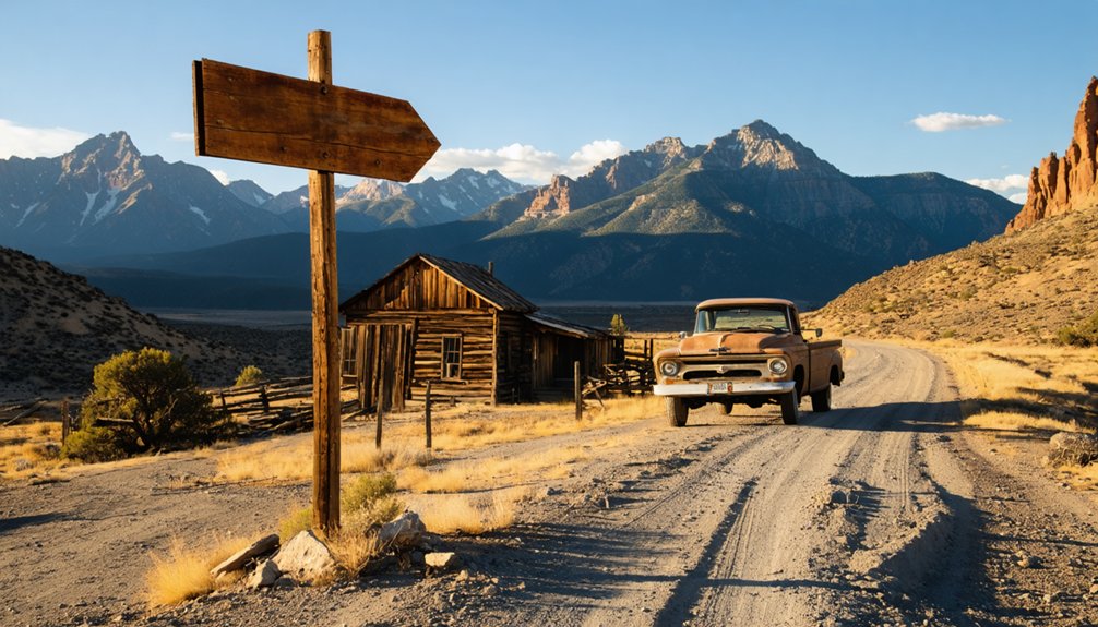
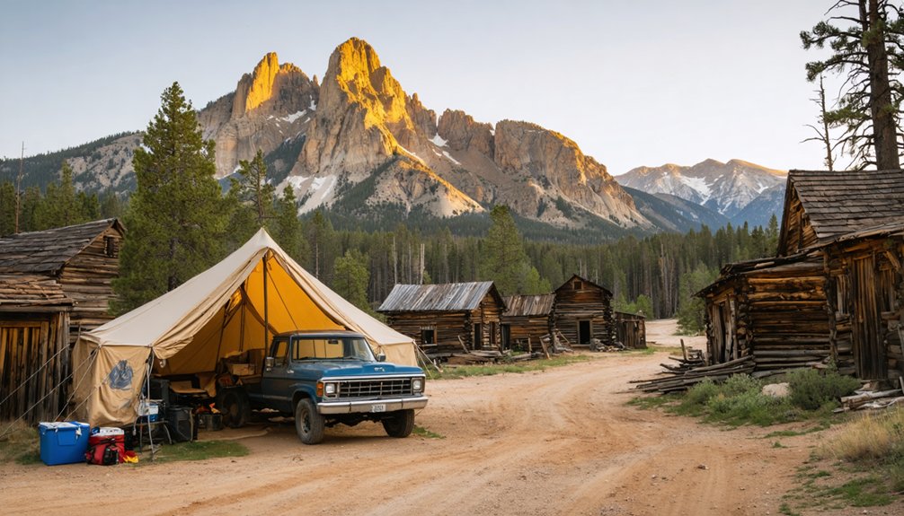
Perched at 8,396 feet in the windswept isolation of Jackson County, Kings Canyon demands more than casual ambition from those who seek its weathered remnants. Your journey begins near Walden, where pavement surrenders to gravel and dirt tracks threading through North Park’s rugged terrain.
Route navigation strategies prove essential—Forest Service roads snake toward the coordinates 40°55′37″N 106°13′37″W, requiring high-clearance 4WD to conquer uneven surfaces and potential stream crossings. Off season access challenges intensify dramatically: winter’s deep snowpack transforms these unmaintained paths into impassable corridors, while spring runoff carves fresh obstacles. You’ll need avalanche awareness at this elevation.
Pack spare tires, tools, and fuel—cell service vanishes here. Verify current conditions with USFS before committing to these unforgiving backcountry arteries.
Best Time to Visit This High-Elevation Ghost Town
Your journey to Kings Canyon at 8,396 feet demands careful timing—the sweet spot lies between late June and early September, when snowmelt opens the rugged access roads and temperatures climb above freezing.
Outside this narrow window, you’ll face the relentless snowstorms that plague this elevation from October through May, transforming already-challenging routes into impassable corridors of white.
Pack layers and rain gear even in peak summer, as afternoon thunderstorms sweep across these heights without warning, dropping temperatures and obscuring trails within minutes.
Summer and Early Fall
The high country beckons from late June through early October, when Kings Canyon’s abandoned settlements emerge from winter’s grip and become genuinely accessible. You’ll find daytime temperatures hovering in the comfortable 70s°F at middle elevations, though nights plunge dramatically—pack layers for 20-30°F swings as you explore higher terrain.
Cedar Grove’s canyon floor sizzles into the 90s°F by midsummer, while Lodgepole runs 10-15°F cooler. August delivers near-perfect conditions: bone-dry trails, minimal precipitation (just 5% daily chance), and clear night skies unmarred by light pollution.
September transforms the landscape with high elevation flora blazing gold and crimson before October’s unpredictable snowstorms reclaim these weathered ruins. Don’t forget your waterproof jacket—afternoon thunderheads occasionally roll through.
Avoiding Heavy Snow Seasons
Winter’s embrace transforms Kings Canyon into an impassable fortress of white, sealing off these weathered ruins from October through May beneath blankets of snow that once drove entire populations from their mountain claims. At 8,396 feet, you’ll face winter snowfall impacts that historically buried neighboring ghost towns under 25-foot accumulations, forcing miners to tunnel between buildings just to survive.
The nearby passes tell cautionary tales—Independence evacuated after 1899 blizzards, while Animas Forks endured avalanches sweeping through narrow canyons like deadly pendulums. Modern avalanche mitigation measures can’t erase nature’s dominance here. You’re free to explore Kings Canyon when summer’s warmth opens up these high-country secrets, but attempting winter access means confronting the same brutal conditions that scattered these settlements into historical footnotes.
Weather Preparation Essentials
Between late June and early September, Kings Canyon sheds its winter armor and reveals itself to those willing to navigate the narrow dirt roads leading to its skeletal remains. You’ll need appropriate hiking boots with ankle support—these crumbling structures demand sure footing on unstable terrain.
Pack layers that shift from morning frost to afternoon sun, because elevation doesn’t negotiate comfort. Water sources here are questionable at best, so master water purification methods before you arrive, whether you’re carrying tablets or a reliable filter system.
The ghost town won’t coddle you with conveniences. Bring emergency supplies, extra fuel, and detailed maps—cell service died here long before the mining boom collapsed. This isn’t a curated experience. It’s raw Colorado backcountry that rewards preparation and punishes carelessness.
What Remains at the Abandoned Copper Mining Site
Scattered across the mountainside like bones of an industrial giant, the physical remnants of Kings Canyon’s copper mining past tell stories of ambition and eventual abandonment. You’ll discover a landscape forever altered by extraction’s hunger:
- Spider-web tunnels honeycomb the mountain, their mouths gaping where a massive plug collapsed, creating a cathedral-sized cavity
- Ore tram tracks snake downward to the lower mill site, rusted rails still pointing toward ghost buildings
- Tailings piles cascade down slopes, their copper-stained sediment mixed with gold ore and quartz fragments
While you’re free to explore this memorial to frontier perseverance, understand the potential environmental risks lurking beneath these historic surfaces. Without long term reclamation plans, acid drainage continues seeping toward the river below, carrying heavy metals through abandoned workings—a toxic legacy time hasn’t diminished.
The Brief History of Kings Canyon’s Boom and Bust
You’ll find Kings Canyon’s story written in rust and rotting timbers—a copper rush that blazed through these mountains like wildfire before extinguishing just as quickly.
The camp roared to life as prospectors chased copper veins through the rock, their pickaxes ringing day and night for eight frenzied years of extraction. By the time the ore played out and the last miners packed their belongings, Kings Canyon had already begun its slow surrender to the wilderness that surrounds you now.
Copper Rush Era Origins
Tucked into Jackson County’s eastern Northgate district, Kings Canyon emerged from Colorado’s mining fever in the late 1800s, when prospectors combing the high country’s river channels stumbled upon gold-flecked gravels that would launch decades of extraction. Those copper mining discoveries transformed this remote canyon into a dual-operation claim, where miners chased both placer deposits and underground veins.
The mineral wealth potential revealed itself through three distinct commodities:
- Copper – The primary target, yielding 720 kilograms by 1994
- Silver – Secondary recovery totaling 250 grams from underground shafts
- Molybdenum – Tertiary finds adding value to extraction operations
Between the 1870s and 1910, Kings Canyon’s shaft-based workings drove deep into Colorado’s backbone, pulling fortune from stone before economic realities shuttered operations during the Depression’s grip.
Eight-Year Mining Operation
While most Colorado mining camps stretched their fortunes across decades, Kings Canyon’s underground shafts tell a different story—one measured in just eight fevered years of extraction. You’ll find this wasn’t gradual development but rapid exploitation driven by copper fever.
Miners burrowed deep into Northgate’s eastern slopes, pulling 720 kilograms of copper alongside silver and molybdenum traces before the resource depletion became undeniable.
The operation’s brief timeline reveals everything about frontier mining’s brutal calculus. They worked underground in relentless pursuit, extracting what they could while ore veins held promise. By 1994’s final tally, the numbers told their stark truth—not enough to sustain a community, barely enough to justify the effort.
What remains now is testimony to ambition outpacing geology, where freedom-seekers gambled everything on mountains that gave up their secrets too quickly.
Essential Gear and Supplies for Your Trip
Before venturing into the high-altitude remnants of Kings Canyon, you’ll need to transform your vehicle into a self-sufficient basecamp on wheels. Whether you’re using rental car services or your own transportation, pack your registration, insurance documents, and that essential spare tire—breakdowns in ghost towns don’t summon AAA quickly.
Your liberation checklist includes:
- Navigation resilience: Download offline GPX files before cellular signals vanish, supplementing digital navigation systems with hard-copy trail maps
- Weather preparedness: A NOAA weather radio app and layered clothing combat Colorado’s mercurial mountain moods
- High-altitude essentials: Altitude medication, extra water reserves, and a 10,000 mAh battery bank keep you autonomous
Pack sunscreen, insect repellent, and your first-aid supplies. This abandoned mining settlement rewards the self-reliant wanderer.
Nearby Ghost Towns to Add to Your Itinerary
Beyond Kings Canyon’s weathered foundations, Colorado’s ghost town network sprawls across the San Juan and Sawatch ranges like scattered pages from a prospector’s diary. You’ll find Animas Forks near Silverton, where the Duncan House’s bay window frames alpine meadows at 11,000 feet—Evalyn Walsh penned her biography here before owning the Hope Diamond.
Carson sits even higher at 12,000 feet outside Lake City, documenting historic mining relics against Weminuche Wilderness vistas. Exploring nearby Tin Cup addition rewards you with rowdy frontier tales and a cemetery filled with sheriff graves.
Near Telluride, Alta’s boarding houses cling to mountainsides where L.L. Nunn pioneered electrical power in 1891. Each town demands four-wheel drive and carries stories of fortune-seekers who refused easy paths.
Understanding the Copper Mining Operations
The copper veins threading through Kings Canyon’s gneiss bedrock tell a story of modest ambitions and hard-won extractions. You’ll discover underground workings where miners pursued quartz lenses yielding 720 kg of copper alongside silver and molybdenum between the 1870s and 1930s.
Geological survey findings reveal a mineral assemblage that dictated ore processing methods:
- Chalcopyrite and bornite provided the primary copper values, supplemented by oxidized malachite and chrysocolla near surface zones
- Pyrite concentrations required careful separation during hand-sorting operations
- Fluorite and molybdenite occurred as accessory minerals within the quartz host rock
The caved adit and scattered workings reflect operations driven by necessity rather than abundance—Depression-era prospectors extracting what freedom they could from Colorado’s unforgiving mountains.
Photography Tips for Capturing Remote Mountain Ruins
When afternoon light rakes across weathered timber frames and rusted corrugated metal, you’ll face technical challenges that separate documentary snapshots from evocative imagery. Bracket multiple exposures to balance Kings Canyon’s harsh mountain sun against deep shadow details—essential when capturing structures perched at extreme elevations.
Bracket your exposures relentlessly—mountain sun devours shadow detail in seconds at these elevations where documentary becomes art.
Infrared black and white photography transforms complex storm clouds into dramatic backdrops above deteriorating mine buildings. Your composition techniques should exploit windows as natural frames for distant peaks, though perspective correction becomes critical on non-square openings.
Scout infinite details in hand-hewn beams and vintage hardware that tell authentic stories. Fresh snowfall enhances textures during afternoon sessions, while pre-dusk lighting reveals architectural bones.
Remember: accessing these remote locations demands high-clearance vehicles and willingness to scramble down steep terrain with equipment.
Safety Considerations at 8,396 Feet Elevation
Exploring Kings Canyon’s abandoned structures at 8,396 feet means your body operates in an oxygen-depleted environment that triggers physiological responses you can’t ignore. Your heart pumps harder, cardiovascular risks multiply, and altitude sickness can ambush unprepared adventurers within hours.
Smart acclimatization strategies protect your freedom to explore:
- Stop in Denver overnight before pushing higher into the Rockies
- Hydrate relentlessly—your body’s losing moisture faster than you realize
- Watch for warning signs: headaches, dizziness, or nausea demand immediate attention
The thin mountain air doesn’t negotiate. Pack acetazolamide if you’re ascending from sea level, avoid alcohol your first day, and don’t ignore chest tightness or confusion. These ghost towns have witnessed enough tragedy—don’t become part of their history.
Camping and Accommodation Options in Jackson County
After traversing ghost towns perched at lung-testing elevations, you’ll crave a base camp that delivers modern comforts without sacrificing wilderness access. Jackson Lake State Park’s campgrounds answer that call with 251 sites ranging from electric-hooked RV pads to primitive tent spots. Camping fees start at $10 daily vehicle passes, with the Lakeside, Cove, and Pelican loops operating October through March.
You’ll find level pull-throughs for big rigs, fire rings for evening storytelling, and showers when trail dust becomes unbearable. The International Dark Sky certification means stars explode overhead once darkness falls. With 3.4 miles of nearby hiking trails and 14-day maximum stays, you’ve got time to properly decompress.
Lake John Resort offers another option—full hookups without the crowd.
Frequently Asked Questions
Are Pets Allowed at Kings Canyon Ghost Town Site?
The information provided covers Kings Canyon National Park in California, not Colorado’s ghost town site. However, you’ll find most historic sites follow pet-friendly policies with leash requirements. Contact the specific Colorado location to confirm their rules before your adventure begins.
Can Artifacts or Relics Be Legally Collected From the Site?
No, you can’t collect artifacts—tempting as these whispers from the past may be. Legal restrictions on relic collection protect these historical treasures, and potential penalties for unauthorized collection include hefty fines that’ll definitely cramp your wandering spirit.
Is Cell Phone Service Available in the Kings Canyon Area?
You’ll find cellular coverage limitations throughout Kings Canyon’s rugged terrain, where deep canyons and remote wilderness create spotty connectivity availability. AT&T, T-Mobile, Verizon, and U.S. Cellular provide service, though signals weaken considerably as you venture deeper into this isolated landscape.
Are Guided Tours Available for Kings Canyon Ghost Town?
Unfortunately, guided tour availability doesn’t exist for this wildly remote destination—you’ll forge your own path here. The tour booking process is nonexistent, meaning you’re free to explore Kings Canyon’s haunting ruins on your own adventurous terms.
What Wildlife Might Visitors Encounter Near Kings Canyon?
You’ll encounter mule deer grazing meadows, playful chipmunks darting through rocks, and diverse bird species soaring overhead. Abundant wildflowers attract hummingbirds and butterflies, while black bears roam higher elevations. It’s nature’s untamed wilderness awaiting your exploration.


