
You’ll find May Day’s ghost town site in northern Riley County, where gravel roads still intersect at the exact crossroads where competing general stores once served German pioneers traveling wagon trails across the tallgrass prairie. Navigate six miles east of the Big Blue River using the 1909 Plat Map of Center Township, following Fancy Creek’s course through rolling hills where limestone bedrock holds ancient fossils. The settlement’s commercial heartbeat—Weichselbaum’s and Sebring’s stores from 1871—has vanished, but the landscape reveals stories of dugouts, sod houses, and the natural springs that made this crossroads thrive before floods and automobiles transformed everything.
Key Takeaways
- May Day is located in northern Riley County, roughly six miles east of the Big Blue River along Fancy Creek.
- Navigate using gravel roads that trace original wagon trails; reference the 1909 Plat Map of Center Township for accuracy.
- The ghost town sits at historic crossroads where competing general stores once served as a wagon trail supply hub.
- Fancy Creek’s clear springs and limestone bedrock with visible fossils mark the settlement’s natural centerpiece and oasis location.
- By 1910, May Day peaked at 59 residents before fading, leaving remnants of its 1871-era commercial crossroads heritage.
The Origins of May Day: From Dugouts to Official Township
Before Kansas became a patchwork of official townships and county lines, the prairie around May Day belonged to those hardy enough to carve homes from the earth itself. Pioneer settlers dug directly into hillsides, creating dugouts and sod-built “soddies” that sheltered them until they could raise proper frame houses. You’ll find this area wasn’t officially surveyed until 1857, existing in a liminal space where township formation meant little to those already staking their claims.
Charles Withington arrived in 1854, becoming the first official U.S. citizen to establish business along the Santa Fe Trail at what would become Allen. By 1855, community growth brought a cluster of buildings—lodgings, supplies, blacksmith shops—near the river crossing, laying foundations for settlements that would eventually fade into Kansas’s ghost town landscape.
Discovering Fancy Creek’s Dancing Waters
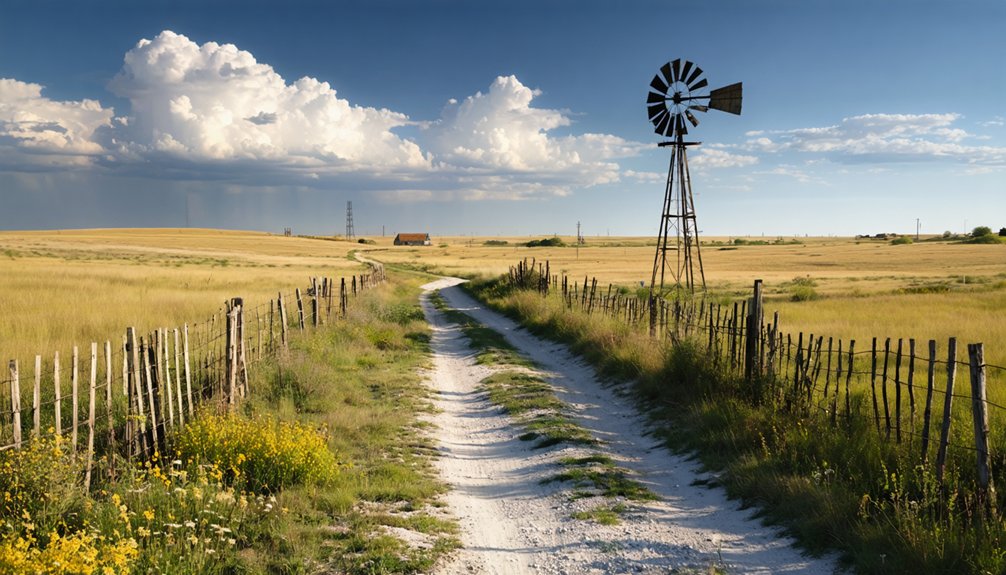
You’ll find the west branch of Fancy Creek flowing through northern Riley County, its name rooted in a local legend about clear water that appears to dance across the rocky streambed. The creek’s crystal-clear springs and reliable water flow made it an oasis on the water-scarce high plains, drawing Frank Droll and Ralph Niehenke to settle its banks in 1857.
Beyond the obvious survival advantage, the creek sat at a natural crossroads of wagon trails, surrounded by thousands of years of rich topsoil accumulation that promised fertile farmland.
Creek’s Distinctive Name Origin
The creek’s name carries a story as fluid as its waters, though settlers never recorded the exact moment someone first called it “Fancy.” Unlike nearby Peter’s Creek, which clearly honors Peter Carlson, Fancy Creek’s designation remains wrapped in local lore and practical observation.
You’ll find this waterway flowing through the township that took its name, winding through the Flint Hills breaks into Blue Valley. The creek’s name origin predates even the township’s 1860 establishment, as Swiss natives Edward and Solomon Secrest already knew it by this designation when they arrived from Seymour, Indiana in 1857.
Early settler migration patterns brought German and Swiss families who settled along these banks, building their lives in dugouts beside waters they found distinctive enough to warrant such an unusual christening.
Crystal Water Rock Formation
Names tell only part of Fancy Creek’s story—its character reveals itself in the crystalline waters that dance over ancient limestone bedrock. You’ll discover chalk deposit characteristics shaped 80 million years ago, when single-celled organisms created layers of sediment on a prehistoric sea floor.
The stream’s clarity comes from filtering through these Cretaceous formations, exposing fossil preservation processes in weathered outcrops along its banks. Watch for pitted surfaces where erosion reveals marine life frozen in time—fish, turtles, and ancient shellfish embedded in the stone.
The creek’s path follows natural weaknesses in the rock, carving through calcium carbonate cement that holds these formations together. Here, water becomes your guide through Kansas’s underwater past, writing freedom across limestone pages.
Settlement Location Advantages
Where Fancy Creek carves through 660 square miles of Clay County’s rolling terrain, early settlers discovered what geologists now confirm—this wasn’t just another Kansas stream. You’ll understand their choice when you see how these advantageous waterways provided year-round flow from the principal Pleistocene aquifer beneath the valley floor. Unlike most county drainage feeding the Republican River, Fancy Creek charted its own course, offering pioneers independence from crowded tributaries downstream.
The settlers recognized strategic transportation routes where limestone and chert created natural fords across the shallow waters. You’re standing where flat valley floors—bordered by protective bluffs rising up to 95 feet—offered ideal town sites. The Dakota Formation aquifer guaranteed reliable wells, while 27.92 inches of annual rainfall supported crops. May Day’s founders weren’t gambling; they’d found Kansas freedom.
Mapping Your Route to Riley County’s Lost Settlement
Finding May Day requires traversing a network of gravel roads that trace the original wagon trails through northern Riley County’s rolling prairie. You’ll navigate by landmarks rather than street signs, following the settlement layout that once defined this crossroads community near Fancy Creek‘s west branch.
Essential navigation points include:
- The 1909 Plat Map of Center Township showing precise boundaries
- Historic wagon trail intersections that formed the town’s core
- Fancy Creek’s course as your primary geographical reference
- Distance markers from the Big Blue River, roughly six miles east
The transportation networks that once brought German pioneers here have evolved into rural routes cutting through productive farmland. You’re retracing paths where Frank Droll and Ralph Niehenke first arrived in 1857, where the rich topsoil they discovered still supports agriculture today.
The Crossroads Commerce Era: Stores That Built a Community
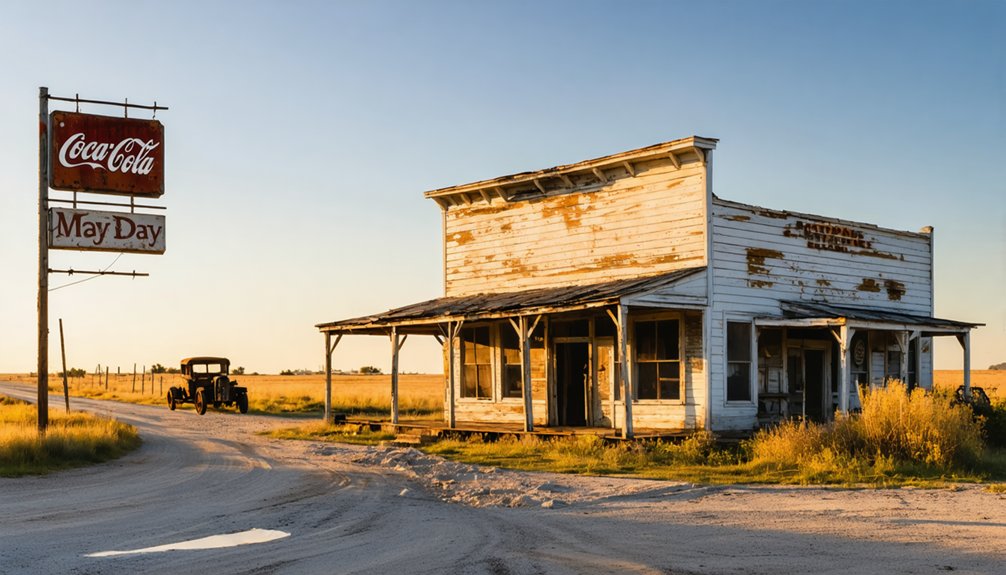
Standing at the intersection of county highway 376 and 1600 Road West, you’ll notice the northwest and southeast corners where Solomon Weichselbaum and John Sebring established competing general stores in 1871. These two pioneer buildings transformed an empty crossroads into May Day’s commercial heartbeat, drawing farmers from across the Blue River Valley to trade cream, eggs, and poultry.
You’re looking at what was once a crucial wagon trail supply hub where settlers could stock provisions, send mail from the post office opened April 13, 1871, and connect with their scattered neighbors in the vast Kansas prairie.
Two Pioneer Store Locations
The crossroads at May Day’s heart tells its story through the corner lots where two rival merchants built their dreams. Solomon Weichselbaum staked his claim on the northwest corner in 1871, establishing the settlement’s first general store.
The crossroads commerce rise began when John Sebring answered with his own store on the southeast corner, creating competition that drew farmers from miles around.
These early storefront locations defined May Day’s identity:
- Northwest corner: Weichselbaum’s original store until the 1884 fire
- Southeast corner: Sebring’s competing establishment
- Diagonal positioning: Maximum visibility for both merchants
- Strategic placement: Direct access to converging wagon routes
You’ll find nothing remains of these pioneer structures today, but their corner lots still mark where two entrepreneurs transformed empty prairie into Kansas’s newest trading post on May 1, 1871.
Lifeblood of Early Trade
Commerce pumped through May Day’s veins from the moment those two stores opened their doors in 1871. You’d witness the commerce significance as farmers rolled up with cream, eggs, and poultry throughout the 1920s-1930s, trading their goods for supplies before those products shipped to Clay Center markets.
The store diversification kept this crossroads thriving—Weichselbaum and Sebring competed on opposite corners until fire claimed one in 1884. Nathaniel Osborne rebuilt bigger on the northwest corner in 1898, while Mrs. Byarlay later added gasoline sales to her home-based operation in 1909.
These weren’t just retail spaces; they sustained 59 residents by 1910, transforming dusty wagon trails into essential trade routes. You’re looking at commerce that defined survival itself.
Wagon Trail Supply Hub
When Solomon Weichselbaum hammered together his general store on that northwest corner in 1871, he wasn’t just constructing a building—he anchored May Day’s identity at the intersection of necessity and opportunity.
This crossroads settlement thrived because wagons stopped here. The Fancy Creek west branch intersection created natural traffic flow, transforming empty prairie into an agricultural trading hub where settlers could actually survive:
- Dual stores emerged when John Sebring built diagonally opposite Weichselbaum’s, giving travelers choice
- Daily essentials flowed through both establishments—tools, flour, fabric, ammunition
- Strategic positioning at the crossroads meant maximum visibility for passing wagon trains
- Community infrastructure followed commerce, with houses and Dr. Silverthorn’s office clustering nearby
You could get what you needed without riding another dusty twenty miles. That freedom mattered.
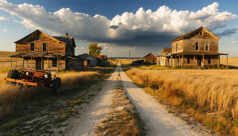
Understanding the Decline: Floods, Automobiles, and Abandonment

Several forces converged to transform May Day from a thriving crossroads settlement into abandoned pastureland. When automobiles arrived in the early 1900s, you’d have witnessed the town’s economic decline accelerate rapidly. Residents no longer needed those general stores at the crossroads—they could drive to larger towns for supplies.
The 1909 plat map revealed no new settlers claimed land, strangling growth permanently.
May Day’s vulnerable geography sealed its fate when the Big Blue River unleashed catastrophic flooding in July 1951. Eight inches of rain over four days devastated the Kansas River basin, affecting 116 communities. Fancy Creek’s proximity, once an asset, became a liability.
What Remains: Exploring the Settlement Sites Today
Today, you’ll find nothing but rolling pastureland where May Day’s crossroads bustled with activity over a century ago. The townsite at Highway 376 and May Day Road stands completely empty, with even the Byarlay store’s foundation buried beneath modern pavement.
Your exploration requires seeking peripheral landmarks:
- Original school site – The 1867 schoolhouse survives one mile east on Fancy Creek Road, the settlement’s sole remaining structure
- Cemetery markers – Located half a mile west, this burial ground preserves names of May Day’s pioneers
- May Day Springs – Downhill water source that sustained early residents still flows naturally
- Ulrich Rothlesberger Farm – Historic farmstead near the vanished townsite
You’ll need to venture beyond the barren crossroads to connect with May Day’s past, as nature has completely reclaimed its commercial center.
Best Times to Visit This Northern Kansas Ghost Town
Planning your journey to May Day requires more than just marking the coordinates—Kansas weather dictates whether you’ll find accessible gravel roads or impassable mud traps. Target early fall, when September’s 60°F days offer ideal seasonal weather without summer’s scorching 90°F heat. You’ll navigate dirt paths easily during these dry months, tracing wagon routes to Fancy Creek’s west branch.
Avoid May through July—periodic flood risks mirror the devastating 1951 deluge that submerged this settlement’s low-lying areas. Spring’s tornado season adds another hazard you don’t need. Late May holds symbolic appeal, commemorating the town’s 1871 founding, but weigh that against muddy conditions.
Dawn visits reward you with prairie light illuminating the abandoned crossroads. Winter’s frozen ground complicates exploration, though holiday weekends guarantee solitude at this forgotten outpost.
Before you set out for May Day’s weathered crossroads, load your vehicle with navigation essentials that transform this ghost town hunt from guesswork into confident exploration. You’ll navigate gravel routes like Highway 376 and Fancy Creek Road, where off road vehicle recommendations include high-clearance models for unimproved trails near the west branch.
As you embark on your hartland road trip highlights, be sure to take in the stunning views and historical landmarks along the way. Each stop reveals unique stories and local secrets that make the journey unforgettable. Don’t forget to capture those moments, as they will be the true treasures of your adventure.
Navigation essentials and high-clearance vehicles turn May Day ghost town exploration from uncertain guesswork into purposeful adventure through remote Kansas backroads.
Pack these critical items:
- Printed Riley County topo maps marking the cemetery, 1867 schoolhouse, and RCFD107 station
- First-aid kit and emergency roadside flares for remote location hazards
- GPS with downloaded coordinates plus compass backup for spotty signal areas
- Flashlight, sturdy boots, and windproof jacket for prairie exposure
You’re 35 miles northwest of Manhattan with limited cell coverage, so self-reliance beats assumptions every time on these isolated Kansas backroads.
Frequently Asked Questions
Were There Any Notable Conflicts Between Settlers and Native Americans Near May Day?
You’ll find May Day sat near significant battlegrounds where settler-Native American tensions erupted violently. The 1875 Battle of Sappa Creek and 1878 Dull Knife Raid transformed traditional Native American hunting grounds into contested frontier territory, claiming dozens of lives.
What Crops Did the Original German Immigrant Farmers Primarily Grow?
German immigrant farmers primarily focused on Turkey Red winter wheat cultivation, which thrived in Kansas’s dry conditions. They’d also practice animal husbandry alongside growing rye, barley, cabbage, potatoes, and corn—crops they’d mastered in their homeland’s harsh climates.
Did May Day Ever Have a School or Church Building?
Yes, May Day had both. You’ll find the 1867 school building still standing one mile east on Fancy Creek Road—the only survivor. Religious congregations built two churches and a cemetery, though those structures haven’t survived.
Are There Any Documented Ghost Stories or Paranormal Reports From the Site?
You won’t find documented ghost stories here. Despite May Day’s eerie abandonment, there aren’t haunting experiences reported by visitors or unexplained phenomena witnessed by locals on record. You’ll need to create your own paranormal adventure at this forgotten site.
What Happened to the Families Who Left After the Town Declined?
You’ll find the fate of abandoned families scattered like GPS pins across Kansas—they resettled in Hutchinson and larger towns seeking opportunities. Resettlement efforts post decline were individual choices, with families independently pursuing commerce, education, and freedom elsewhere.


