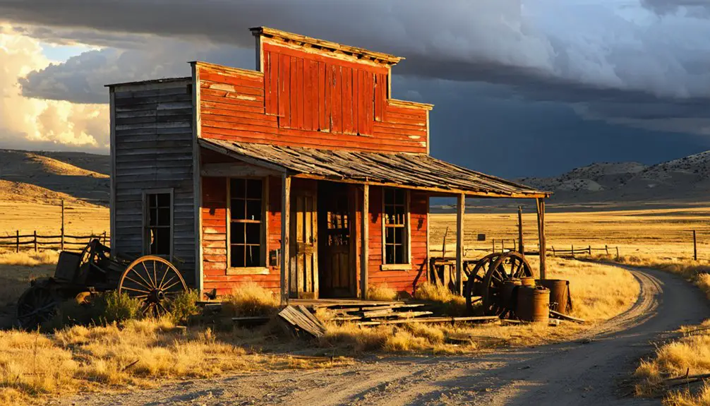
Your ghost town road trip starts at South Pass City, where 30+ restored buildings anchor your exploration of the Sweetwater Mining District‘s 15-mile circuit. You’ll navigate gravel roads through 7,800-foot sagebrush valleys, discovering Mineral Hill‘s concrete mill foundations, Atlantic City’s weathered remnants, and Miners Delight‘s preserved cabins—all within easy driving distance. Pack water and prepare for Wyoming’s unpredictable mountain weather, as these remote sites reveal how quickly boomtowns collapsed when gold veins played out and the deeper history behind each settlement’s rise and fall.
Key Takeaways
- Mineral Hill features massive concrete foundations and tiered remnants from its two-story gravity-fed processing mill, documented in 1962 photographs.
- The mill site sits beside the townsite with scattered stamp mill and cyanide vat equipment across the terrain.
- Nearby South Pass City became Wyoming Territory’s second-largest town after Mormon prospectors struck gold in 1867.
- Atlantic City and Miners Delight offer additional ghost town stops within the same Sweetwater Mining District gold fever region.
- Plan to see historic wagon ruts near Highway 28, 70-foot-high trestle remnants, and preserved 1880s-era structures.
The Gold Rush Legacy of Wyoming’s Sweetwater Mining District
When prospectors first spotted gold glinting in the streams near South Pass in 1842, they couldn’t have imagined the frenzy that would grip these windswept hills twenty-five years later. The 1867 Carissa Mine discovery transformed this remote landscape into a magnet for fortune-seekers. South Pass City exploded into existence, followed by Atlantic City and Miners Delight, where 200 men hammered away at veins yielding $5,000 per ton.
You’ll find the district’s history marked by native conflicts—Sioux warriors struck repeatedly in 1869 and 1870, killing miners who’d violated the Fort Laramie Treaty. The economic impacts rippled beyond gold: Union Pacific‘s coal operations launched in Rock Springs, Chinese workers hewed railroad ties, and production soared from 2.1 to 2.9 million tons between 1906 and 1912.
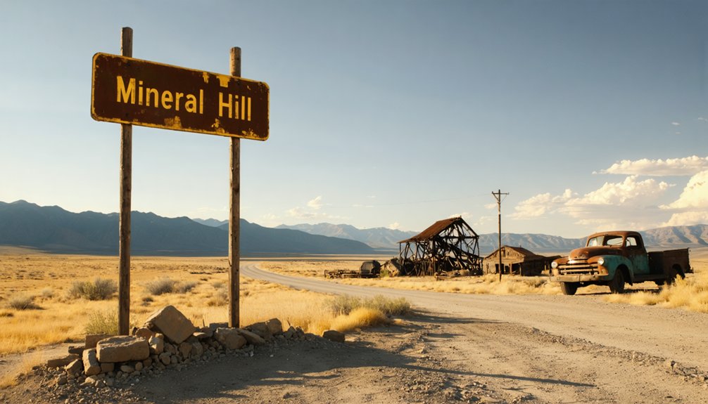
Discovering Mineral Hill’s Historic Mill Remnants
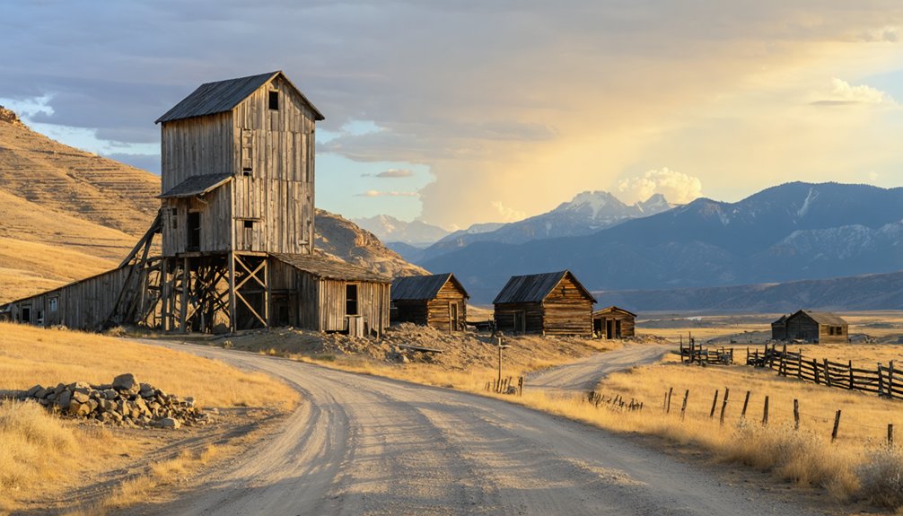
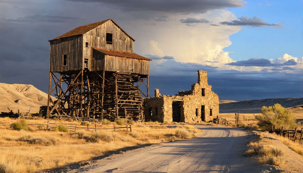
When you examine the 1962 photographs of Big Mineral Hill’s mill, you’ll notice the massive concrete foundations that anchored a two-story processing facility spanning roughly 60 by 40 feet. The documentation reveals a gravity-fed design where ore entered at the upper level and moved downward through crushing stamps and separation tables—an efficient layout you can still trace by walking the tiered foundation remnants today.
These archival images capture the mill’s final years before demolition, showing weathered timber framing and rusted equipment that once thundered day and night processing Mineral Hill’s gold-bearing quartz.
1962 Mill Documentation
As you approach the east side of Spotted Tail Creek, you’ll find yourself standing where Mineral Hill’s primary mill once dominated the landscape. Though the structure’s vanished, its foundations tell the story of intensive mill operations that once processed ore from surrounding mines. Your photographic documentation will capture these remnants:
- Foundation outlines marking the mill’s original footprint
- Half-dozen mine building sites clustered nearby on the creek’s east bank
- Scattered house foundations positioned at higher elevations on both creek sides
- Structural base patterns revealing the complex’s layout
You’ll need to walk the site methodically—these subtle traces require careful observation. The ten residential foundations and mine-related structures create a sprawl that demands exploration on foot, giving you freedom to discover each remnant’s unique story.
Structural Features and Layout
Standing among the mill foundations, you’ll notice how Mineral Hill’s engineers defied conventional wisdom by positioning their processing facility beside the townsite rather than near the mine entrance. The orebody structural characteristics reveal why this setup worked—six major veins formed an en echelon pattern within a N-trending anticline, creating lodes that ranged from mere centimeters to five meters wide.
The vein formation patterns followed a northeast-southwest strike with a steep 70-degree dip, extending two hundred feet underground. Engineers compensated for the awkward mill placement by constructing an impressive water delivery system: an 11-foot-wide ditch feeding flumes perched on 70-foot-high trestles stretching 500 feet across the valley.
You’ll spot remnants of stamp mills and cyanide vat equipment scattered across the terrain.
South Pass City: From Oregon Trail Outpost to Mining Boomtown
Long before South Pass City sprang to life as a rough-and-tumble mining camp, this wind-swept valley served as one of the most critical waypoints in westward expansion. You’re standing where half a million emigrants crossed the Continental Divide between 1841 and 1869, their wagon ruts still carved into the earth near Highway 28.
Everything changed in summer 1867 when Mormon prospectors struck gold:
- Discovery sparked immediate population influx – 1,000 fortune-seekers by 1868
- Carissa Mine’s rich vein launched prospecting opportunities across 250+ buildings
- Wyoming Territory’s second-largest town emerged within two years
- Fort Stambaugh established 1870 after constant Arapaho, Cheyenne, and Sioux raids
The boom busted by 1869, but you’ll explore 23 restored structures packed with 30,000 authentic artifacts from this wild chapter.
Atlantic City and the Wind River Range Gold Fever
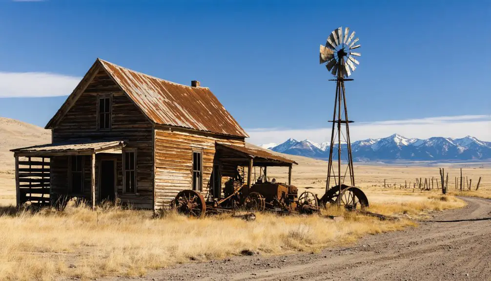
Just three miles northeast of South Pass City, Atlantic City emerged from the same 1868 gold fever that transformed this remote corner of the Wind River Range into Wyoming’s richest strike. You’ll find this settlement tucked against the southern tip of the range, where prospectors discovered veins along Willow Creek that sparked a rush of thousands into the Sweetwater Mining District.
The boom didn’t last. By the early 1900s, played-out mines triggered economic devastation across the Lewiston District. Population decline followed quickly as gold extraction diminished and miners abandoned their claims. Today, Atlantic City stands as a stark reminder of the Old West’s boom-and-bust cycles—a place where greed and opportunity collided in the high country, then vanished just as fast.
Miners Delight: Hamilton City’s Transformation and Preservation
You’ll spot the weathered remains of what locals first called Hamilton City in 1868, before miners renamed it Miner’s Delight after the productive gold mine on Peabody Hill.
The camp swelled to roughly 100 residents by 1870, supporting saloons, general stores, a hotel, and a stamp mill that processed ore from Spring Gulch’s claims.
When the Bureau of Land Management stepped in during the 1970s to purchase and fence the site, they preserved seventeen log structures that had somehow survived a century of Wyoming winters.
Hamilton City Name Change
When gold-seekers first staked their claims in the late 1860s, they christened their muddy settlement Hamilton City—a straightforward name honoring early prospectors who’d gambled on South Pass area veins. But as fortune-hunters flooded in, the name origins shifted to capture boomtown fever.
By the early 1870s, Hamilton City had transformed into Miners Delight—a brilliant marketing move reflecting mining culture’s eternal optimism.
The rechristening signaled four key changes:
- Population surge bringing saloons, stores, and Wyoming’s first newspaper
- Image makeover emphasizing opportunity over hardship
- Boomtown identity distinguishing it from neighboring camps
- Marketing appeal attracting fresh waves of hopeful prospectors
You’ll find that name still marks the ghost town today, preserved since the 1960s as legacy to Wyoming’s glittering, fleeting gold rush dreams.
Population and Business Growth
At its roaring peak in the 1880s, Miners Delight swelled to roughly 2,000 souls—a maze of canvas tents, log cabins, and false-fronted businesses crowding the sagebrush hills. Gold fever drew fortune-hunters from across continents, their picks ringing against quartz veins until exhaustion hit hard.
By 1900, fewer than 50 diehards remained. The historical demographics tell a brutal story: 2,000 to three residents by 1940, then absolute zero.
Today’s count? Still zero. No saloons, no general stores—just weathered timber and silence. Yet there’s a tourism based resurgence of sorts: seasonal visitors wander the ruins, snapping photos where stamping mills once thundered. You won’t find commercial revival here. Wyoming’s preservation mandates froze Miners Delight in time, trading population growth for authenticity. That’s precisely what makes it worth the dusty drive.
1960s Preservation Efforts Begin
Similar preservation efforts you can explore include:
- Carissa Mine and Mill – Acquired in 2003, offering tours of one of the world’s best-preserved mining operations from 1867
- History Under The Pines Project – Documenting Black Hills sites while maintaining site anonymity to protect against vandals
- Fossil Wyoming Revival – Community-driven restoration at Fossil Butte National Monument
- Grand Encampment Museum – Showcasing relocated Battle-area buildings
These preservation victories prove you’re witnessing history rescued from certain disappearance.
Notable Landmarks: The Carissa Mine, Idaho House, and Fort Bourbon
Standing as the crown jewel of the South Pass mining district, the Carissa Mine beckons visitors with its weathered headframes and meticulously restored mill buildings perched against Wyoming’s windswept ridgeline. You’ll explore three shafts plunging 90-450 feet deep, where Robison and Terry’s 1867 discovery sparked South Pass City’s gold rush. The state’s $200-acre preservation project lets you witness ore-processing equipment that once crushed 60 tons daily.
While unexplained legends swirl around Idaho House and Fort Bourbon—supposed landmarks lacking any documented footprint—you won’t find them here. Elusive historic records suggest confusion with distant Oregon Trail stops. Focus instead on what’s real: walking the Carissa’s timber-framed mill, touching schist walls that yielded millions in gold, and standing where fortune-seekers once chased freedom in every glittering vein.
Planning Your Multi-Site Ghost Town Adventure
Mapping out your ghost town circuit requires strategic timing and realistic mileage expectations across Wyoming’s unforgiving distances. The South Pass cluster—South Pass City, Atlantic City, and Miners Delight—offers concentrated exploration within a 10-mile radius, letting you absorb rich historical background from the 1867 gold rush without backtracking. You’ll encounter preservation challenges firsthand at sites like Mineral Hill’s 1962-photographed mill remnants and Gebo’s crumbling early 1900s structures.
Wyoming’s ghost towns demand careful planning—vast distances separate fragile historical sites where preservation battles against relentless high-altitude weathering.
Your Multi-Site Strategy:
- Southern Route: South Pass City’s 1870 jail and Idaho House, then Atlantic City tucked in the Wind Rivers
- Northern Plains: Gebo’s coal town ruins and weathered cemetery
- Mountain Circuit: Centennial’s Mountain View Hotel and Acme shaft house
- Remote Discovery: Gold Hill’s 1890s camp in the Centennial Mining District
When you venture into Mineral Hill’s backcountry, you’re confronting elevation swings that’ll test both your vehicle and your stamina—Wyoming’s topography rockets from 916-meter river valleys to 4,047-meter peaks, and these ghost towns cluster in the unforgiving middle ranges where weather pivots from scorching sun to sleet within hours.
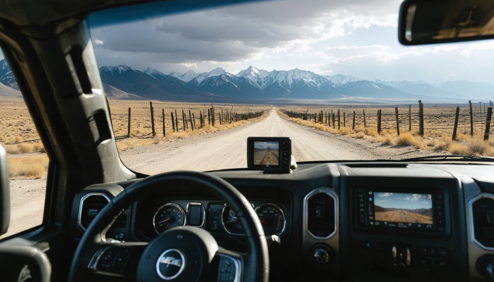
Download satellite imagery analysis before losing cell service; those overhead views reveal washouts that paper maps won’t show. Gravel road conditions deteriorate fast after storms, transforming passable routes into axle-breaking nightmares.
I’ve watched August snowflakes dust my windshield at 2,400 meters while valley thermometers hit 30°C. Pack chains, emergency supplies, and detailed USGS topographic maps—the interactive WSGS resources pinpoint exactly where maintained roads surrender to primitive tracks. Remote means genuinely isolated here.
What Remains Today: Boom-Bust Cycle and Conservation Efforts
The remote accessibility that protects Mineral Hill today also sealed its economic doom. When ore quality plummeted beyond 100 feet, the town’s fate was sealed—no wagon road costing $2,500 could save it. You’ll find Wyoming’s boom-bust cycle written in weathered wood and rusted metal.
What survives tells the story:
- Mountain View Hotel stands on the National Register, defying conservation challenges
- Stamp mill remnants marking $3,000 in extracted gold
- Shaft house foundations from failed reopening attempts
- Building skeletons documenting the 1890s settlement layout
Long term sustainability here means preservation through isolation. The geological reality that killed profitability now protects these structures from development. You’re witnessing freedom’s price—fortunes risked on wishful thinking, communities built on hope, then abandoned when nature refused to cooperate.
Frequently Asked Questions
Are Any Buildings at Mineral Hill Safe to Enter?
No buildings remain safe to enter at Mineral Hill—only foundations survive. You’ll find the big mill and community structures completely gone. Before exploring, consider safety precautions around unstable ground and consult local authorities about accessing this private land.
What Photography Equipment Works Best in Wyoming Ghost Towns?
You’ll need photography gear that’s practically bulletproof against Wyoming’s harsh elements. Wide-angle camera lenses capture expansive abandonment, while photographic filters tame intense light. I’ve found sturdy tripods and powerful headlamps essential for exploring dark interiors safely.
Can I Camp Overnight Near Mineral Hill?
You’ll find dispersed camping options throughout Thunder Basin National Grassland near Mineral Hill, where you can pitch your tent freely among scenic overlooks. Contact Douglas Ranger District at 307-358-4690 for current regulations before heading out.
Are There Guided Tours Available for the Sweetwater Mining District?
You’ll find guided tours at nearby Carissa Gold Mine in South Pass City, where you can explore Wyoming’s mining history through authentic structures and working mill demonstrations. The Sweetwater County Historical Museum also offers customizable guided tours focusing on regional mining heritage.
What Cellphone Service Is Available in the Area?
Cell service is extremely limited near Mineral Hill’s remote terrain. You’ll find sparse signal strength and few cell tower locations in the Sweetwater Mining District. Union Wireless offers your best rural coverage, though you should download offline maps before departing.