You’ll discover Mohave County’s haunting past by starting in Chloride, where 5,000 fortune-seekers once chased silver veins through vertical tunnels. Drive twenty winding mountain miles from Kingman to explore collapsed headframes and rusting mining equipment. Continue to Mineral Park, where open-pit excavation swallowed the former county seat that served 700 residents. Don’t miss Route 66’s Valentine and Nothing, where crumbling storefronts and weathered signs mark America’s Mother Road. Pack one gallon of water per person, wide-brim hats, and navigation equipment—the complete guide below reveals essential preparations for safe exploration.
Key Takeaways
- Pack essential safety gear including one gallon of water per person daily, headlamps, first-aid supplies, and personal locator beacons.
- Visit Chloride, 20 miles from Kingman, to explore collapsed tunnels and rusting headframes from its 1870s silver boom.
- Explore Mineral Park’s site where five smelters once operated before becoming a massive copper excavation in 1964.
- Drive Route 66 to Valentine and Nothing to photograph abandoned motels, service stations, and weathered business signs.
- Wear wide-brim hats, SPF 30 sunscreen, quick-drying pants, and broken-in hiking boots for desert exploration comfort.
When you venture into Mohave County’s rugged backcountry, you’ll trace the same paths that prospectors and freight wagons carved through the Cerbat Mountains over 150 years ago. Navigate to Chloride first, perched 45 miles west of the Colorado River, where historic mining operations transformed wilderness into thriving settlements by the 1860s.
Your route connects resourceful pioneer communities that defied isolation through sheer determination. Wind through mountainous terrain to discover Cerbat’s Golden Gem head frame still standing sentinel over scattered debris. Continue to Goldroad’s crumbling adobe walls, then explore Oatman’s former boomtown sites where 500 residents once enjoyed electric lights and graded streets.
Each dirt road reveals Montana Camp’s remnants near Ruby, where 1,200 souls vanished within months after 1940’s ore depletion. Pack navigation tools and water—cell service remains as scarce as it was in frontier days.
Mineral Park: From County Seat to Open-Pit Excavation
Among the scattered ghost towns dotting Mohave County’s mountainous spine, Mineral Park stands apart—not for what remains, but for what vanished beneath one of Arizona’s most productive open-pit mines.
You’ll find only five ruins marking where Mohave County’s seat once thrived from 1877 to 1887, serving nearly 700 residents. This juniper-filled basin witnessed dramatic boom and bust cycles—from silver discovery in 1871 through five competing smelters and three newspapers, to complete abandonment by 1912.
The Duval Corporation‘s 1964 operation transformed the landscape entirely, extracting 646 million pounds of copper where courthouses once stood. Architectural preservation efforts never materialized here; instead, you’re witnessing industrial-scale reclamation.
Today’s active mining operations restrict access, but surrounding areas still yield turquoise and copper—tangible connections to Mineral Park’s resource-driven legacy.
Chloride’s Enduring Legacy in the Desert Mountains
Reaching Chloride requires traversing twenty miles of winding mountain roads from Kingman, the same treacherous supply route that once challenged freight wagons hauling equipment to seventy-five active mines carved deep into the Cerbat Range.
The shafts beneath your feet plunge hundreds of feet through silver chloride veins that drew five thousand fortune-seekers to this elevation by the 1870s. You’ll find remnants of this vertical underground empire everywhere—collapsed tunnels, rusting headframes, and stone foundations where hoisting equipment once lifted ore and miners between the surface and the darkness below.
Remote Supply Route Challenges
The Colorado River steamers that churned upstream from Fort Yuma carried every sack of flour, bag of coffee, and mining tool destined for Arizona’s remote interior settlements. When low water halted these lifeboats of commerce, camps survived on beans and hope alone.
You’ll find that challenging terrain access turned simple deliveries into month-long ordeals—wagon teams wrestling through Union Pass’s 3,680-foot climb while mail service interruptions left miners starved for news and supplies. Shipping ore to San Francisco cost so much that anything under $500 per ton meant pure loss.
Heavy rainstorms transformed the Mojave Road into impassable mud, forcing desperate detours through hostile territory. Yet prospectors pushed forward anyway, driven by veins rich enough to justify the brutal isolation.
Deep Mining Operations History
While supply wagons still struggled through Union Pass, prospectors in the Cerbat Mountains struck silver veins so rich they’d transform Chloride into northwestern Arizona’s most enduring mining camp.
You’ll discover shaft construction techniques that drove operations 243 feet underground, where tunnels extended thousands of feet beneath 600-foot backs. Power source innovations arrived by 1935—electric compressors replacing steam—enabling deeper exploration of gold and silver veins valued at $30 per ton.
What you’ll experience in Chloride’s mining legacy:
- Vertical shafts plunging into darkness where miners once descended by candlelight
- Hand-carved drifts and raises echoing with pickaxe strikes from the 1900s
- Abandoned mill foundations where cyanide processes extracted precious metals
- Tungsten relics from wartime operations when production peaked desperately
- Living ghost town atmosphere among 1,134 documented Mohave County mines
Cedar Valley and Goldroad: Remote Settlements of the Hualapai Range
As you wind through the Hualapai Range‘s eastern slopes, Cedar Valley‘s scattered rock foundations reveal a settlement that once housed two hundred souls, including physicians who tended to miners extracting gold, silver, and copper from the stubborn earth.
The Gold Road Club stood as Goldroad’s social heart, where Henry Lovin’s freighting wagons delivered supplies to four hundred residents working the low-grade ore that sustained operations for three decades.
Today, roofless adobe walls and crumbling stone mark where these remote communities thrived before the veins ran dry and the desert reclaimed its own.
Cedar Valley’s Medical Community
Remote mining settlements like Cedar Valley faced formidable healthcare challenges that transformed improvised field medicine into organized community care. You’ll discover how Arizona’s territorial expansion paralleled the development of specialized healthcare facilities, particularly tuberculosis sanatoriums that drew patients seeking the desert’s healing climate.
These remote outposts rarely maintained permanent doctors, relying instead on traveling physicians and folk remedies.
The harsh realities miners confronted:
- Crushed limbs from dynamite accidents with no surgeon within 50 miles
- Silicosis ravaging lungs from years breathing rock dust underground
- Pneumonia striking during bitter winter nights in canvas tents
- Infected wounds festering without proper antiseptics or trained hands
- Families watching loved ones deteriorate, powerless against preventable diseases
Arizona’s territorial health board wouldn’t form until 1903, leaving early settlements desperately self-reliant in their medical struggles.
Goldroad Mine Operations History
When Jose Jerez struck his pickaxe into a quartz outcropping somewhere between 1897 and 1900, he couldn’t have imagined the glittering chunk would assay at 40 ounces per ton—a discovery that would transform barren Hualapai Range slopes into one of Arizona’s richest gold producers. Grubstaked just $12.50 by Henry Lovin, Jerez’s claim sold for $50,000 in 1901, then flipped for $275,000.
Early exploration efforts pushed a shaft 15 feet deep within months. By 1902, the incorporated Gold Road Mining & Explorations Company employed 180 miners. Despite mining challenges from declining veins after 1907, the operation persevered through multiple closures and reopenings—1911, 1922, 1936—driven by fluctuating gold prices. The mine ultimately yielded nearly 750,000 ounces before final closure in 2015.
Modern Ghost Towns: Nothing and Valentine Along Historic Route 66
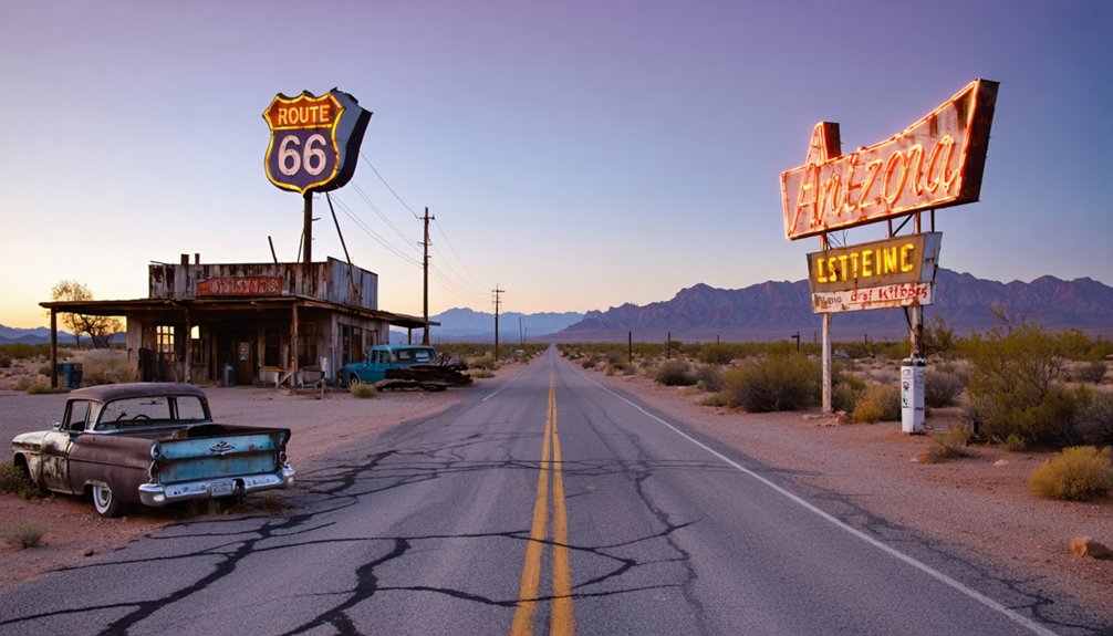
Two forgotten settlements along Historic Route 66 tell the story of America’s Mother Road through their crumbling facades and empty storefronts. Valentine, once home to several hundred travelers and Native American families, now shelters just 36 souls among ruins of the 1901 Truxton Canyon Indian Training School.
You’ll find Bert’s Country Dancing Bar‘s weathered sign still beckoning phantoms of past revelers. Nothing earned its peculiar name honestly—I-40’s 1960s bypass transformed this services hub into absolute abandonment.
Ghost town experiences await at these Mother Road relics:
- Explore decaying service stations where Route 66 travelers once filled their tanks
- Walk through the haunting remains of the Native American boarding school
- Photograph faded business signs advertising long-vanished services
- Stand beside abandoned motels that housed cross-country adventurers
- Discover authentic local business relics untouched by tourist restoration
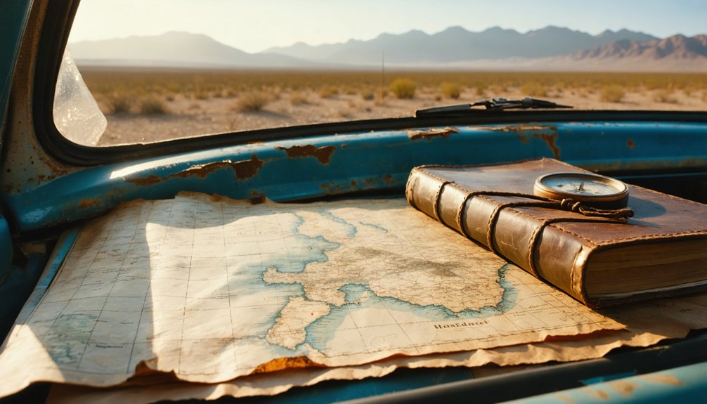
What to Pack and Prepare for Your Desert Exploration
Desert exploration demands meticulous preparation—your survival hinges on what you’ve packed before cellular signals fade into static. Wide-brim hats shield you from relentless sun while SPF 30 sunscreen prevents painful burns across exposed skin.
Layer lightweight quick-drying pants over breathable base layers; desert temperatures plummet once darkness swallows the horizon. Your broken-in hiking boots grip shifting sand while gaiters block scorching granules from infiltrating your socks.
Accommodations for desert camping require one gallon of water per person daily—dehydration strikes faster than you’d imagine. Pack headlamps with extra batteries, first-aid supplies including moleskin for inevitable blisters, and personal locator beacons for safety precautions in remote areas.
Your power bank keeps communication devices charged. These essentials transform dangerous isolation into liberating adventure among forgotten ghost towns.
Frequently Asked Questions
Are These Ghost Towns Safe to Explore Without a Guide?
You’ll find ghost towns generally safe for solo exploration, though personal safety concerns like unstable structures warrant caution. Your trip planning considerations should include sturdy footwear, water supplies, and telling someone your route—freedom requires smart preparation.
What Photography Restrictions Exist at These Historic Mining Sites?
You’ll face few formal restrictions at most mining sites, though you can’t use drones or disturb artifacts. The lighting conditions change dramatically throughout the day, perfectly capturing each structure’s historical significance through your lens freely.
Can I Legally Take Artifacts From Abandoned Ghost Town Buildings?
Like a treasure hunter facing locked vaults, you’re prohibited to remove artifacts from Mohave City’s ruins. Government property rights protect these historic remnants—taking them risks $20,000 fines and criminal charges, ending your freedom-seeking adventure abruptly.
Which Ghost Towns Require Four-Wheel Drive Vehicles to Access?
Signal Ghost Town, Swansea, and areas around Alamo Crossing all demand 4WD due to challenging off road trail conditions. You’ll navigate washed-out ascents, rocky descents, and rugged desert terrain where vehicle accessibility separates explorers from daydreamers.
Are Overnight Camping Facilities Available Near These Mohave County Locations?
Yes, you’ll find abundant camping options throughout Mohave County. From lakeside campgrounds at Lake Mohave to BLM dispersed sites, nearby lodging ranges from $5-$50 nightly. You’re free to choose rustic tent sites or full-hookup RV parks for your adventure.


