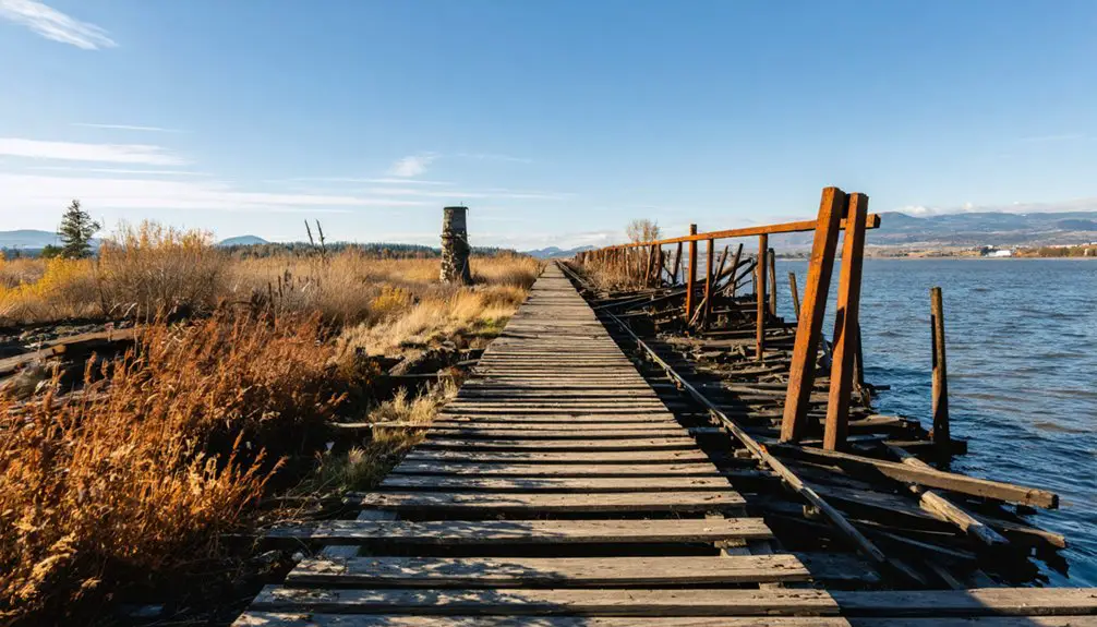
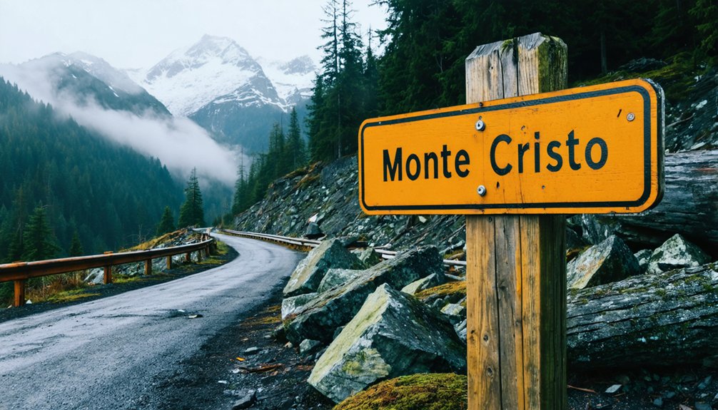
You’ll drive the Mountain Loop Highway 34 miles northeast from Granite Falls, following the South Fork Stillaguamish River until pavement surrenders to gravel at Barlow Pass. Park with your Northwest Forest Pass, then hike the level 4-mile railroad grade—crossing a massive fallen log—to reach Monte Cristo’s ghostly remains. Rusting tram buckets, crumbling foundations, and interpretive signs tell stories of 1,000 dreamers who chased silver into these unforgiving peaks, while extended trails lead to even more remote mining sites beyond the main townscape.
Key Takeaways
- Access via Mountain Loop Highway from Granite Falls; first 34 miles paved, final 13 miles gravel requiring high-clearance vehicle.
- Obtain a Northwest Forest Pass and park at Barlow Pass trailhead; arrive early on summer weekends to secure parking.
- Hike 4 miles on level railroad grade to reach Upper and Lower town sites with interpretive signs and mining relics.
- Check road conditions with Verlot Public Service Center before departure, as winter storms may close the highway seasonally.
- Expect no cell service and plan for 8-mile round trip with potential mud, downed trees, and river crossing challenges.
The Rise and Fall of a Cascade Range Mining Boomtown
When Joseph L. Pearsall stumbled upon silver ore in 1889, he unknowingly triggered a cascade of events that would transform the South Fork of Sauk River into a thriving metropolis. You’ll find Monte Cristo’s story mirrors the classic boom-and-bust cycle—from wagon roads carved in 1891 to a railroad delivering mining equipment innovations by 1893.
The town swelled past 1,000 souls by 1894, processing 300 tons of ore daily. You’d have earned $2.50 per day, minus board.
But freedom came with consequences. Avalanches, floods, and erratic ore bodies crushed dreams by 1897. The long term environmental impacts became undeniable—ASARCO’s 2009 bankruptcy settlement funded extensive cleanup. Today, you’ll witness nature reclaiming what ambition built, a stark reminder of extraction’s true cost.
How to Get There: Accessing the Mountain Loop Highway
Winding northeast from Granite Falls, the Mountain Loop Highway unfurls like a ribbon through the Cascades, its pavement smooth beneath your tires for the first 34 miles. You’ll find mountain loop highway access points where SR 92 meets the byway, just 40 minutes from Seattle’s concrete sprawl. Stock up on nearby amenities in Granite Falls—fuel, food, and supplies—before committing to the wilderness ahead.
The road shadows the South Fork Stillaguamish River, climbing toward Barlow Pass at 2,349 feet. Here, pavement surrenders to 13 miles of groomed gravel: dusty, potholed, and gloriously remote. Your high-clearance vehicle handles the narrow sections and blind corners at 25 mph. Cell service vanishes. Nine miles later, you’ll emerge onto pavement again, rolling into Darrington where civilization cautiously returns.
Trail Details: What to Expect on Your 8-Mile Journey
Beyond Barlow Pass, the old railroad grade stretches before you—a 4-mile ribbon of packed earth that once rattled with ore cars and steam engines. The trail conditions remain surprisingly navigable despite decades of neglect, though you’ll weave around downed trees and washed-out sections that tell stories of floods past.
The terrain stays mostly level with accessibility features that welcome families and casual hikers—even wider-wheeled chairs handle most sections, though muddy patches and spongy ground test your resolve.
Your main challenge? Crossing the South Fork Sauk via a massive fallen log. Don’t believe the online hysteria—it’s stable, equipped with a rope handrail, and far less intimidating than reported. For the genuinely hesitant, a bypass trail exists one mile ahead, though it’ll cost you extra elevation.
Parking Requirements and Permits You’ll Need
The weathered parking lot at Barlow Pass sits like a dusty amphitheater at the Mountain Loop Highway’s eastern edge, where pavement gives way to wilderness and your adventure truly begins. You’ll need a Northwest Forest Pass displayed on your dashboard, though permit enforcement here flows hot and cold depending on ranger presence. Check the trailhead signage—it’ll tell you the current status.
During peak summer weekends, this lot transforms into a chaotic puzzle of bumpers and backpacks. Arrive early or risk roadside parking along the highway’s shoulder, where traffic whips past faster than you’d expect.
Seasonal accessibility remains generally reliable year-round at the trailhead itself, though winter storms occasionally close the Mountain Loop Highway entirely. Before heading out, verify road conditions through the Verlot Public Service Center, especially after heavy weather.
Exploring the Upper and Lower Town Sites
After four miles of hiking along the old railroad grade, you’ll spot those rust-red buildings through the trees—but don’t let them fool you into thinking you’ve arrived. That’s just the old train station. Continue another mile to discover Monte Cristo’s fascinating settlement patterns, where railroad tracks literally divided society.
Upper Town crowns the hillside with Dumas Street’s commercial backbone—school, church, post office—where businessmen claimed view properties during the 1893 boom. Below the tracks, where Glacier and 76 creeks converge, you’ll find Lower Town‘s skeleton: saloon foundations, worker housing, Frederick Trump’s real-estate office. Interpretive signs mark building sites throughout both areas. The residential demographics tell everything about this vertical hierarchy—steep terrain forced a tiered community that separated by class and profession.
Mining Relics and Historic Buildings You’ll Discover
As you wander through Monte Cristo’s rugged terrain, you’ll spot massive eyebolts still embedded in rock faces—remnants of the patented Bleichert tramway that once hauled ore down these steep hillsides.
Scattered ironized rocks and chunks of ore mark the path where covered ground tramways carried crushed mineral to the five-story concentrator, now long vanished.
Look for interpretive signs near foundation outlines and the underground breakroom where 1890s miners sheltered between shifts, their tools and rusting equipment still visible 3800 feet into exploratory tunnels.
Equipment and Tramway Ruins
Scattered across Monte Cristo’s steep talus slopes, rusting tram buckets and cable anchor points tell the story of an engineering marvel that once hauled 230 tons of ore daily down from Mystery Ridge. You’ll spot Bleichert’s patented cable system remnants where rock anchors still grip mountainsides, connecting mines to the valley terminal below.
These tram engineering marvels integrated seamlessly with crushing operations—covered ground tramways fed ore into the five-story concentrator building while aerial cables spanned impossible terrain.
Inside accessible tunnels like Mystery Pride’s 3800-foot network, you’ll find forgotten equipment from the 1890s, including an underground breakroom where miners sheltered. The 2015 cleanup removed toxic tailings, but original cable foundations and scattered buckets remain. Bring hiking boots; there’s no road reaching these iron ghosts clinging to wilderness slopes.
Upper and Lower Towns
Monte Cristo’s desperate search for flat ground split the community into two distinct zones, where residents clung to whatever narrow ledges the mountain valley offered. You’ll find residential layout patterns stretching across tiered housing on both levels, where 2,000 souls once squeezed themselves into this vertical settlement.
The lower town’s main street—now the Dumas Street trail—showcases commercial service diversity through scattered foundations of hotels, saloons, stores, and even a newspaper office.
Scattered mining relics tell Upper Town’s story: rusted wheels, the five-level concentrator’s remains from 1894, and metal scraps from 211 claims that once promised fortune. Down below, partial cabins still stand defiantly against time, their weathered boards marking where boarding houses and lodges buzzed with activity before flooding and brutal winters drove everyone out by 1907.
Interpretive Signs and Landmarks
Your exploration of this abandoned townsite becomes richer when you discover the interpretive signs the Monte Cristo Preservation Association installed throughout the valley. Written by Louise Lindgren, these markers reveal the historical significance of interpretive signs at key locations—from the metal welcome panel at the entrance to a complete circle at the old hotel site detailing the community’s rise and fall.
You’ll find mining relics strategically displayed near the signs, including ore concentrator remains and tramway fragments that once hauled silver-lead down steep hillsides. MCPA preservation efforts continue through volunteer work parties every third Saturday, June through October, maintaining the few surviving 1890s structures like Weden House Station and protecting the railway grade you’re walking on from further deterioration.
The Rockefeller Connection and Other Colorful Characters
Behind every ghost town lies a cast of ambitious dreamers and shrewd opportunists, and Monte Cristo’s story weaves together some of America’s most recognizable names.
exploring monte cristo ghost town allows visitors to step back in time and witness the remnants of a once-thriving community. As you wander through the dilapidated buildings and mining sites, the echoes of the past come alive. Each corner turned offers a glimpse into the lives of those who sought fortune and adventure in this remote landscape.
You’ll discover that John D. Rockefeller bankrolled the railroad extension that made mining possible, partnering with Cleveland investors and New York financiers. When Frederick Trump‘s investments entered the picture in 1894, he cleverly opened a hotel near the train station, profiting from miners’ hopes while silver lodes disappointed. His earnings eventually funded the family real estate empire that produced a future president.
After devastating floods and bankruptcies, Rockefeller’s financial restructuring through adviser Frederick Gates salvaged operations in 1899. Gates ousted original partners and rebuilt infrastructure with Japanese laborers before selling non-mining holdings to railway magnate James J. Hill—a final chapter in this frontier drama.
Natural Disasters That Sealed Monte Cristo’s Fate
While ambitious investors and colorful entrepreneurs shaped Monte Cristo’s rise, nature ultimately authored its demise. You’ll discover a cascade of catastrophes that transformed this boomtown into abandoned ruins:
- The 1897 Flood – Swollen by rain and snowmelt, the raging torrent undermined massive trees, creating log jams that trapped families and triggered infrastructure failures throughout the valley.
- Relentless Avalanches – Steep Cascade slopes sent deadly snowslides crashing through operations, with the 1920 avalanche finally ending all mining attempts.
- The 1980 Washout – This powerful flood severed the county road, isolating Monte Cristo and accelerating its economic decline as a tourist destination.
- Continuing Devastation – Subsequent floods in 2003 and 2006 destroyed remaining road access, leaving only hiking trails to reach this wilderness ghost town.
Extended Adventures to Gothic and Glacier Basins
Nature’s destructive power may have claimed Monte Cristo’s buildings and roads, but it simultaneously sculpted some of the most spectacular alpine terrain in the Cascades. You’ll find Gothic Basin 30 miles east of Granite Falls, where a 9.2-mile trek rewards you with sapphire Foggy Lake and unmatched peak bagging opportunities.
The trail climbs 2,840 feet through switchbacks and avalanche chutes, crossing Weden Creek three times before reaching the basin’s colorful rocks and chirping marmots. You’ll scramble past Kong’s Tower waterfall and through Morning Star Natural Resources Conservation Area, where mineral diversity created a prospector’s dream.
Gothic Peak and Del Campo Peak tower above, their rugged faces offering freedom-seekers technical challenges. Come July through October when snowmelt reveals this hidden sanctuary.
Frequently Asked Questions
What Should I Bring for the Hike and Town Exploration?
Your journey’s freedom starts with comfortable hiking shoes grounding each step. Pack appropriate weather gear, water purification, the Ten Essentials, and camping equipment. You’ll traverse mining-scarred trails, documenting history while prepared for mountain’s unpredictable moods.
Are There Camping Options Near Monte Cristo or Barlow Pass?
You’ll find six free primitive campsites at Monte Cristo Campground after a scenic 4-mile trek, plus dispersed camping spots along the river. Silvertip Campground sits 1.5 miles in, offering secluded wilderness freedom without reservations needed.
When Is the Best Season to Visit Monte Cristo?
Summer opens Monte Cristo’s gates from June through August, offering ideal weather conditions and clear trails. You’ll find accessibility during off season challenging—spring mud and fall’s unpredictability demand experience, but reward adventurous spirits with solitude.
Is the Trail Suitable for Children or Dogs?
Yes, the trail’s suitable for both! The difficulty level of trail remains easy on this flat, 4-mile route. You’ll handle downed trees and mud easily. Dogs love exploring here. Potential wildlife encounters add excitement to your family’s adventure.
Can I Enter the Remaining Buildings or Just View Them?
Look but don’t touch—you can’t enter the remaining buildings due to their unsafe interior condition. The accessibility to historic structures is limited to exterior viewing only, as deteriorated walls and floors make entry dangerous for freedom-seeking explorers like yourself.