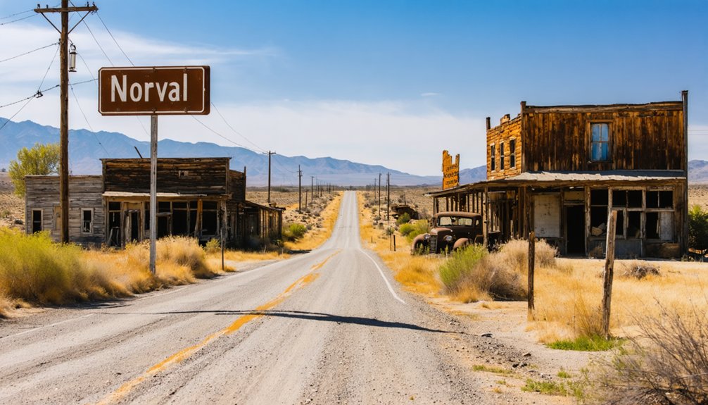
You’ll find Norval hidden in Kern River canyon, a faded gold rush settlement where cement foundations and rusting equipment mark where fortune-seekers once worked the Big Blue mine’s rich deposits. The remote location demands a high-clearance 4×4, offline navigation tools, and plenty of water as you navigate terrain that hasn’t changed much since the 1880s. Consider pairing Norval with nearby ghost towns like Calico or Ballarat to create an unforgettable multi-day adventure through California’s mining heritage.
Key Takeaways
- Norval, a 1850s gold rush settlement in California’s Sierra foothills, became a ghost town after placer gold depleted around 1880.
- The remote site features cement mill foundations, rusting mining equipment, and collapsed wooden structures reclaimed by sagebrush and wilderness.
- Standard GPS may fail in this isolated terrain; bring offline navigation tools and research historical mining routes beforehand.
- A high-clearance 4×4 vehicle is essential, along with ample water, food, first-aid supplies, and preparation for extreme temperatures.
- Combine Norval with nearby ghost towns like Calico, Ballarat, or Empire Mine for a comprehensive gold rush circuit.
Discovering Norval’s Mining Heritage and Ghost Town Status
The dusty trails of Kern County hold secrets that most ghost town hunters never uncover, and Norval stands among the most enigmatic. You’ll find this forgotten camp likely emerged from the 1850s Kern River gold rush, when prospectors discovered those rich placer deposits yielding up to $50 per pan.
While historic mining claims like the Big Blue and Mammoth mines drew attention to nearby Cove district, Norval remained a minor operation that faded after the placer boom. The Cove district’s total production reached 262,800 ounces through 1959, with the Big Blue mine alone accounting for over $1.7 million in gold. The Walker family had migrated to this Kern River country from California’s mother lode region and were well-regarded in the mountain community by 1880. Today, you’re chasing shadows of lost gold veins and decayed camps that once dotted these mountains.
The town probably vanished when easy gold exhausted by 1880, leaving behind only whispers of those intermittent operations that limped through the 1930s.
Getting to Norval: Location and Access Routes in Kern County
You’ll find this forgotten settlement deep in California’s Gold Rush heartland, where historical transportation networks once carried fortune-seekers through rugged Sierra terrain. The journey itself becomes part of your ghost town archaeology adventure—tracing routes that freight wagons and determined miners carved through wilderness over 150 years ago.
Navigate through the Sacramento Region using modern highways that shadow those original paths. Your GPS might struggle here; these settlements weren’t built for convenience.
The surrounding Calaveras County terrain reveals why prospectors chose such remote locations—isolation meant security for their claims. The Kern River area attracted its own wave of gold seekers during the Southern California gold rush of the 1850s and 1860s. The discovery of oil in 1899 transformed Kern County’s landscape, spawning new settlements like Oil City and Oildale alongside earlier mining communities. Pack supplies and download offline maps. Cell service vanishes where ghost towns hide, leaving you genuinely disconnected from modern constraints.
What to Explore Among Norval’s Barren Remains
Scattered across Norval’s windswept landscape, the skeletal remains of mining infrastructure tell stories that crumbled cemetery headstones can’t. You’ll discover remnants of mining operations—scattered prospect holes, weathered dumps, and the ghostly presence of abandoned structures that once hummed with fortune-seekers’ ambitions.
Cement foundations mark where mills processed ore, while rusting equipment lies frozen in time. The barren terrain reveals scattered wood and tin buildings in various states of collapse, each one a commemoration to dreams that dried up with the gold deposits. Sagebrush growing in the streets reclaims what civilization abandoned, a silent witness to nature’s patient reconquest.
There’s no guided tour holding your hand here—you’re free to wander among the ruins, piecing together Norval’s narrative from what fire, weather, and time haven’t claimed. As mining regulations increased, jobs and investments dried up, transforming what were once bustling communities into the desolate landscapes visible today. This desolation offers something sanitized attractions never will: authentic, unfiltered history.
Building Your Multi-Stop Ghost Town Itinerary
Planning your ghost town odyssey demands more than enthusiasm—it requires strategic route-building that transforms scattered ruins into a cohesive narrative arc. You’ll anchor your journey along Highway 395’s 400-mile backbone, connecting Norval’s forgotten legacy today with thriving stops like Bodie and Cerro Gordo. This corridor enables the history of Norval’s booming past while maintaining access to preserved sites.
As you venture further along the route, you may want to explore the ghost towns near Independence Flat, each with its own unique story of abandonment and decay. These remnants of a bygone era stand as silent witnesses to the challenges faced by those who once sought fortune in the rugged landscape. With each stop, you’ll uncover tales that deepen your understanding of the rich history embedded in these deserted places.
Essential multi-stop framework:
- Northern circuit: Start at Shasta State Historic Park, progress through Empire Mine and Malakoff Diggins (770 miles, 3-6 days)
- Desert triangle: Link Calico, Ballarat, and Cerro Gordo via rugged 4-mile dirt tracks
- Sierra shift: Navigate CA-190 east from Death Valley to Owens Lake, rejoining CA-395 at Lone Pine
- Nevada extension: Add Rhyolite and Goldfield beyond Bodie for cross-state exploration
The northern circuit showcases the evolution of gold mining technology, from Old Shasta’s 1850s rush to Malakoff Diggins’ hydraulic mining revolution of the 1870s. Budget adequate time at Empire Mine, where guided tours from May through September reveal the intricate five-square-mile network that yielded 5.6 million ounces over a century. The desert triangle covers approximately 500 miles total, showcasing some of California’s most beautiful yet harsh landscapes between your ghost town destinations.
Essential Preparations for Your Desert Ghost Town Adventure
Before the sun bleaches your windshield and the Mojave’s silence swallows your engine hum, your ghost town expedition lives or dies by what you’ve packed. Your high-clearance 4×4 needs inspection—tires, brakes, suspension—because Norval’s neighbors like Calico demand off road vehicle safety when pavement surrenders to gravel.
Load a gallon of water per person daily; dehydration doesn’t negotiate in San Bernardino County’s furnace. Pack three days of non-perishables, first-aid with snakebite treatment, and navigation tools that work offline—cell towers abandoned these coordinates decades ago. Some coastal ghost towns like Parisa south of Half Moon Bay grew crops such as barley, wheat, and potatoes, catering to logging industries rather than mining booms.
Backcountry survival skills aren’t optional when you’re informing contacts of your route through Darwin or Silver City. Travel grouped. Carry spare tires, flashlights, and weather-appropriate layers for 100°F days and 40°F nights. Calico itself thrived after four prospectors discovered silver in the multi-colored Mojave Desert mountains in 1881. The desert rewards preparation, punishes improvisation.
Frequently Asked Questions
Are There Any Documented Ghost Sightings or Paranormal Reports From Norval?
No documented ghost sightings exist for Norval specifically. You won’t find haunting legends or unexplained phenomena tied to this abandoned mining outpost. However, California’s ghost town trails offer plenty of paranormal encounters if you’re seeking supernatural adventures elsewhere.
Can I Legally Camp Overnight Near the Norval Ghost Town Ruins?
Like a whisper fading into wilderness, Norval lacks designated campsites. You’ll face privacy concerns and potential trespassing issues on private land. Instead, explore nearby San Bernardino County campgrounds where you’ll find legal sites respecting both freedom and boundaries.
What Specific Minerals Were Mined at Norval During Its Operational Years?
I don’t have specific information about minerals mined at Norval in the background material provided. However, you’ll likely find gold deposits and silver deposits were extracted there, typical of California’s desert ghost towns during mining booms.
Are There Any Remaining Building Foundations or Structures Still Standing Today?
No structures remain at Norval today. Unlike California’s preserved ghost towns, you’ll find no crumbling foundations or abandoned equipment marking this vanished settlement. The site’s completely returned to nature, offering only open landscape where buildings once stood.
Do I Need Special Permits to Photograph or Explore Norval’s Site?
You won’t need special permits for Norval’s remote site, but you should respect private property boundaries and obtain local photography permissions if structures exist on claimed land. The freedom-loving desert welcomes explorers who tread thoughtfully.
References
- https://www.insp.com/stories/top-6-ghost-towns-in-the-west/calico-california/
- https://www.youtube.com/watch?v=ZtBc0thPiyE
- https://en.wikipedia.org/wiki/List_of_ghost_towns_in_California
- https://historyexp.org/wp-content/uploads/2022/10/History-of-Yuba-County-1879.pdf
- https://westernmininghistory.com/library/36/page1/
- https://vredenburgh.org/mining_history/pages/west_mojave_desert.htm
- https://www.historynet.com/blood-feud-in-the-kern-river-country/
- https://hrc.csub.edu/tales-from-the-vault-12/
- https://www.youtube.com/watch?v=JI-eY4RSyGA
- http://explore.museumca.org/goldrush/dist-greenhornmountain.html


