
Your ghost town road trip to Old Kiowa begins along K-2 highway, which traces the 1905 Denver, Enid and Gulf Railroad’s historic corridor through southern Kansas. You’ll discover Belvidere’s scattered business district foundations and Wellsford’s dual railroad remnants, where Rock Island and Santa Fe tracks once ran parallel. Stop at Haviland’s Quaker settlement junction, then visit Kiowa—ground zero for Carrie Nation’s first saloon-smashing raid in 1900. The following sections reveal essential navigation tips and hidden landmarks throughout this vanished railroad landscape.
Key Takeaways
- K-2 highway follows the 1905 Denver, Enid and Gulf Railroad route from Wichita to Old Kiowa near Oklahoma’s border.
- Belvidere features scattered business district foundations; Wellsford shows dual railroad corridors despite highway construction destroying most structures.
- Haviland marks a rare junction where Santa Fe and Rock Island tracks intersected, honoring abolitionist Laura S. Haviland.
- Greensburg, the county seat, rebuilt sustainably after a 2007 EF5 tornado and houses the Big Well landmark.
- Drive cautiously as 91% of Kansas crashes occur on non-interstate routes, mostly from driver error during daylight.
Understanding Kiowa’s Railroad Legacy and Historic Downtown

When the Chicago, Rock Island & Pacific Railway pushed its line from Hutchinson through Kiowa County in 1886, it sparked a systematic town-building campaign that would define the region’s geography for generations. You’ll discover that railroad companies established towns alphabetically from east to west—Arden, Brandon, Chivington, Diston, and Eads—creating a linear pattern still visible today.
The Missouri Pacific expanded throughout the county from 1865 to 1890, establishing sixteen stops that served both railroad freight operations and railroad passenger services. By 1887, Haviland became a rare junction where Santa Fe and Rock Island tracks intersected, though the Santa Fe later abandoned its route.
Infrastructure like coal chutes (1902) and water storage tanks (1905) supported steam locomotive operations, while massive stockyards facilitated the shipping of livestock and agricultural products.
Getting to Kiowa: Routes Through Former Santa Fe Rail Corridors
You’ll find Kiowa one mile north of the Oklahoma border along K-2 highway, which traces portions of the Denver, Enid and Gulf Railroad‘s 1905 route from Enid to this former rail terminus. The historic corridor, acquired by Atchison, Topeka and Santa Fe Railway in 1907, shaped today’s highway alignments connecting southern Kansas to the state line.
From Wichita, travel south on US-81 to Medicine Lodge, then east on K-160 to K-2—a 60-mile journey from Enid follows these former rail paths that once sustained Kiowa’s position as a border crossing point.
Historic Railroad Routes Today
Several historic Santa Fe rail corridors still guide modern highways to Old Kiowa, though the tracks themselves have long vanished from this ghost town landscape.
You’ll find historic railroad alignments running southwest from Kiowa toward the Texas Panhandle, following routes constructed between 1886–1887. These corridors once formed Santa Fe’s essential shortcut to western lines, with tracks opening to Panhandle City by January 15 following the Purcell connection on June 12, 1887.
Today’s rural roads trace these abandoned paths through Barber County, where you can still spot foundations of abandoned locomotive repair shops near former junction points.
The Woodward-to-Amarillo route, completed during this same construction period, parallels modern highways that’ll take you through authentic cattle-shipping territory that defined Kansas’s railroad heritage.
Modern Road Access Points
Today’s main highway access to Kiowa follows US-54, the primary east-west corridor through southern Kansas that connects the Oklahoma border to Missouri while passing near Wichita. You’ll navigate Wichita’s six-lane Kellogg Avenue freeway construction, a 16-mile stretch completed through mid-1980s upgrades and 2019 interchange improvements.
After passing I-35, continue eastward as Barber County highway extensions lead toward your destination.
Key Route Markers:
- I-235 interchange – Northern Wichita access point
- I-135 intersection – Central Wichita junction
- Kansas Turnpike connection – Toll road alternative
- Webb Road/Greenwich Road exits – Eastern Wichita departure (opened 2020)
From Kiowa, KS-2 provides direct paved access through downtown, connecting west to Hardtner and northeast to Hazelton and Anthony. Save offline directions before departing, as mobile coverage varies across rural Barber County roads.
Exploring Belvidere and Wellsford Ghost Town Sites
You’ll find Belvidere’s most distinctive feature in its post office, which served the community from its 1888 platting until operations ceased, while the settlement’s water struggles left minimal infrastructure behind.
Wellsford stands apart as the only Kiowa County ghost town where both Rock Island and Santa Fe Railroads laid parallel tracks through the townsite, creating dual rail corridors that still mark the landscape. Today, both locations retain scattered foundations and structural remnants that correspond with their documented business districts—Belvidere near the Medicine River bottomland and Wellsford along its double railroad grades.
Belvidere’s Post Office Legacy
Before Belvidere earned its name meaning “beautiful view” in Italian—bestowed by the wives of ranchers Iowa Watson and C.P. Fullington—post office operations began under the designation “Glick” in nearby Comanche County in 1883. This facility eventually relocated to Belvidere’s future site in Glick township, Kiowa County, establishing key mail service connections for the region’s scattered settlers.
Belvidere’s mail service evolved substantially through these phases:
- 1883: Glick post office established in Comanche County
- Pre-1912: Post office relocated near Belvidere town site
- 1912: Village upgraded to money order post office status
- 2007: Post office photographed, though no longer operational
You’ll find the surviving post office structure stands as tangible evidence of this communication lifeline that once served Belvidere’s population of thirty residents in 1910, before Rural Free Delivery transformed frontier mail operations.
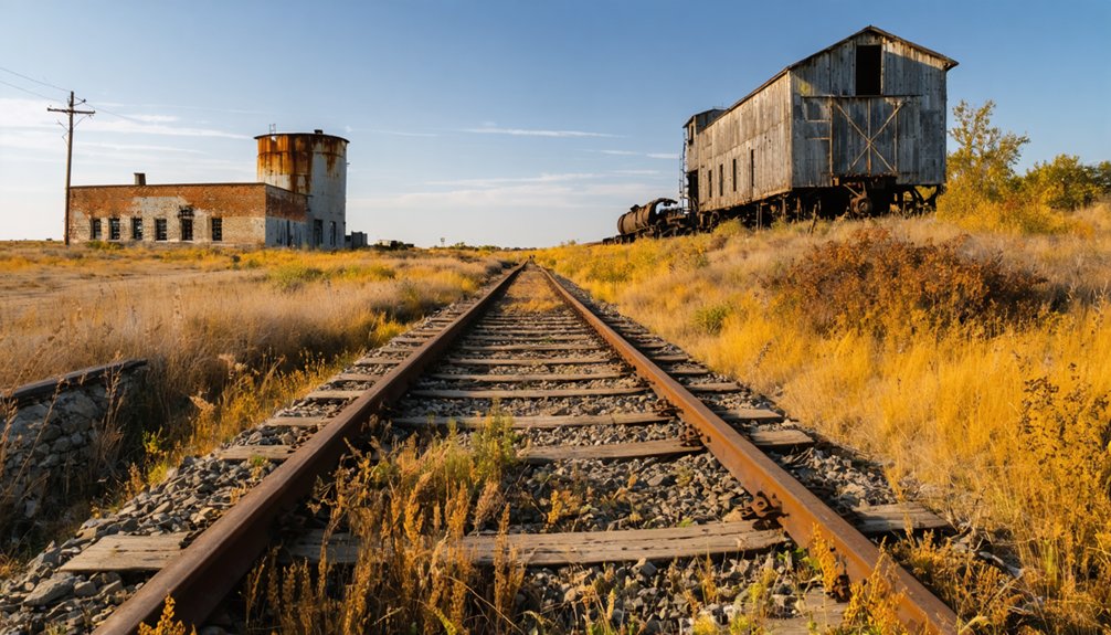
Wellsford’s Twin Railroad Tracks
While most Kansas settlements relied on a single railroad line for survival, Wellsford distinguished itself as one of the rare communities where both the Rock Island and Santa Fe Railroads laid parallel tracks through town. This transportation innovation created unprecedented prosperity, supporting seven livery stables, multiple general stores, and seven newspapers operating at different times. The parallel tracks maintenance enabled multiple rail services that transformed Wellsford into a thriving trade center after 1887.
However, the AT&SF removed its tracks near the turn of the century, shifting operations westward to Pratt. This decision devastated Wellsford alongside neighboring communities like Greensburg, Haviland, and Cullison. Without dual railroad service, trade evaporated quickly. By 1910, Wellsford’s population plummeted to just 100 residents, accelerating its inevitable transformation into another Kansas ghost town.
Remaining Structures and Foundations
Today’s explorers of Belvidere can still examine tangible remnants of this former railroad hub scattered across the Kansas prairie. You’ll discover crumbling stone foundations marking where businesses once thrived along the main street, while buried cellars reveal residential patterns throughout the abandoned blocks. The century-old church stands as the site’s most prominent survivor, accompanied by the 1870s schoolhouse that’s weathered Kansas elements for generations.
Key structures you’ll encounter:
- Original farmhouse and barn complex near the church grounds
- Additional period buildings positioned behind the main farmhouse
- Foundation outlines visible along both primary and secondary streets
- Barrett Cemetery’s headstones documenting settlement chronology
At Wellsford, you’ll find considerably fewer remains since highway construction obliterated most structures. The historical marker provides essential context where buildings once stood before road development necessitated their removal.
Greensburg: County Seat and Tornado Recovery Story

When Governor John Martin organized Kiowa County on March 23, 1886, he simultaneously proclaimed Greensburg as the county seat, settling what could’ve been a contentious battle among prairie settlements. Named for stagecoach driver D.R. “Cannonball” Green, the town absorbed nearby Janesville to secure faster land titles. You’ll find the county courthouse at 211 E. Florida, though it required extensive renovations after May 4, 2007, when an EF5 tornado destroyed 95% of Greensburg, killing eleven residents.
What followed demonstrated remarkable community resilience after disaster. The city council mandated LEED platinum standards for all reconstruction—America’s first municipality requiring this. Today’s innovative green rebuilding includes ten wind turbines powering the town, with carbon offsets funding future sustainability projects.
The Famous Greensburg Well and National Register Landmarks
Beyond Greensburg’s modern sustainability achievements stands its most enduring landmark—the Big Well, a monument to 19th-century engineering ambition that predates the town’s recent reinvention by more than a century. You’ll descend 105 steel stairs into this 32-foot-diameter shaft, hand-excavated by 12-30 laborers using pickaxes and barrels between 1887-1888 to reach the Ogallala Aquifer 109 feet down.
The site’s architectural significance earned multiple recognitions:
- National Register of Historic Places listing (1972)
- American Water Landmark designation (1973)
- Named among 8 Wonders of Kansas (2008)
- Established as national museum (1972)
Following the 2007 F5 tornado, well restoration projects preserved the structure while rebuilding the viewing canopy. Today’s Big Well Museum documents both its original railroad-era purpose and Greensburg’s transformation into America’s greenest small town.
Haviland’s Quaker Settlement and Abolitionist Heritage

Just seventeen miles northeast of Greensburg, the town of Haviland preserves a legacy that extends beyond Kansas prairie settlement into America’s abolitionist movement.
Founded in 1884 by four Quaker men from Indiana, the community honored Laura S. Haviland, a Michigan abolitionist who operated the state’s first Underground Railroad station during the 1830s. Her River Raisin Institute admitted students regardless of race or sex—revolutionary principles reflecting Quaker values in daily life.
Carrie Nation’s Saloon Raid and Sundown Town History
While Haviland’s Quakers championed equality and human dignity, Kiowa’s most infamous chapter unfolded sixteen years after its founding when Carrie Nation selected the town for her first saloon-smashing raid on June 6, 1900. Claiming divine instruction, she demolished three unlicensed establishments using improvised weapons—whiskey bottles, bricks, and rocks she called “smashers.” Authorities filed no charges since the saloons violated Kansas’s prohibition enforcement efforts.
Nation’s documented methodology included:
- Targeting the Horseshoe Saloon with pool balls and bottles
- Destroying two additional establishments across the street
- Declaring war on “predatory liquor traffic and government licensing”
- Inspiring her Smasher’s Mail publication through resulting fame
Her 30+ subsequent arrests across Kansas made Kiowa ground zero for tactics that ultimately influenced national Prohibition.
Abandoned Railroad Lines and Ghost Town Remnants
As Carrie Nation’s notoriety faded into history, Kiowa’s economic lifeline—its railroad connections—began a decades-long decline that transformed the region into a landscape of abandoned tracks and vanished depots.
You’ll find evidence of the Atchison, Topeka & Santa Fe’s 1886-1887 expansion through Kiowa to Woodward, connecting short line corridors that once promised prosperity. The impacts of receivership hit hard in 1893, presaging future abandonments.
By February 1934, the Medicine Lodge-Gerlane segment (Docket 10371) disappeared—7.59 miles erased from Barber County. Missouri Pacific tracks now lie dormant in town plats, parallel to vacated streets.
The Kiowa, Chickasha and Fort Smith Railway’s 24.2-mile Oklahoma line vanished in 1942, leaving only archival records of December 1903’s first operations.
Before venturing onto Kiowa County’s rural road network, you’ll need to understand the infrastructure maintained by the county Road and Bridge Department, which oversees asphalt, sand, and gravel roads alongside their associated bridges and ditches. Rural road safety statistics reveal concerning trends: 83% of Kansas fatal crashes occur on highways and local county roads, underscoring the critical importance of driver awareness and behavior.
Critical Safety Factors:
- 91% of Kansas crashes happen on non-interstate routes
- Most collisions stem from driver error—inattention, right-of-way violations, following too closely
- Commercial Motor Vehicle accidents prove exceptionally more dangerous
- Majority of crashes occur during daylight in good weather
Check real-time conditions through KanDrive Map or WeatherBug traffic cameras. Contact the Highway Department at 620-723-2531 for road inquiries.
Frequently Asked Questions
What Accommodations Are Available Near Kiowa and the Ghost Town Sites?
You’ll find plenty of fish in the sea for lodging: Kiowa Motel offers indoor corridors one mile north of the Kansas-Oklahoma line. Nearby bed and breakfasts include Bunkhouse Suites, while local camping options and Airbnb rentals provide additional freedom.
Are the Ghost Town Sites on Private Property Requiring Permission?
Yes, many ghost town sites involve private property ownership. You’ll need to respect posted boundaries and seek local landowner permissions before exploring. Some structures remain on working farmsteads, while others offer public access areas with clear signage.
What Cell Phone Coverage Exists in Rural Kiowa County Areas?
You’ll find cell phone signal strength varies greatly—Verizon leads at 93.4% county coverage, AT&T follows at 91.2%, while T-Mobile trails third. Data coverage availability weakens near remote settlements, so download maps beforehand for your independent exploration.
When Is the Best Season to Visit Kiowa County Ghost Towns?
Spring and fall offer ideal conditions for exploring Kiowa County ghost towns. You’ll find comfortable seasonal weather patterns perfect for photographing historical preservation efforts, fewer crowds restricting your movement, and dramatic skies enhancing your documentation of these abandoned settlements.
Are There Guided Tours Available for the Ghost Town Locations?
Most Kansas ghost towns offer self-guided tours rather than formal guides—you’ll explore independently like frontier settlers charting territory. However, nearby locations feature historical reenactments and guided experiences, such as Kansas City’s Lizzie Borden Ghost Tours covering haunted sites.


