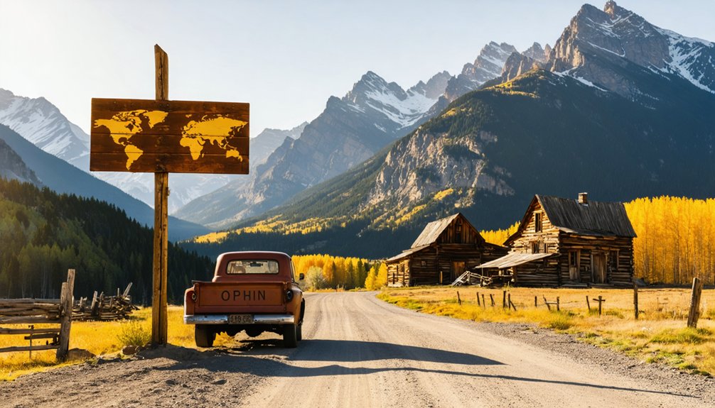
You’ll need a lifted Jeep or SUV with off-road tires to reach Ophir, perched at 9,625 feet in Colorado’s San Juans, where 51 dogs outnumber the residents and 1890s wooden buildings stand frozen in time. Plan your visit for fall when crowds disappear and the treacherous Ophir Pass remains passable—winter and spring bring deep mud, washouts, and avalanche closures that can isolate this living ghost town for days. The journey rewards you with tales of silver booms, Sherman Act busts, and nature’s ultimate authority over human ambition.
Key Takeaways
- Ophir sits at 9,625 feet in the San Juan Mountains, accessible from US Highway 145 with a lifted Jeep or off-road SUV.
- Visit in fall for ideal conditions and minimal crowds; winter and spring access is impassable due to snow and mud.
- The town features 1890s wooden structures and the original 1878 post office, preserving its mining-era character.
- Ophir Pass offers a challenging 10-mile route to 11,789 feet with narrow, rocky shelf roads and scenic forest views.
- Avalanche danger closes roads late fall through spring; 70% of access roads lie in high-risk avalanche paths.
From Gold Rush Boom to Near-Abandonment: The Story of Ophir
The whisper of riches that swept through the southern Rocky Mountains in July 1858 transformed from rumor to roar as 100,000 gold seekers descended on Colorado’s wild terrain during the Pike’s Peak gold rush.
A whisper of riches transformed into a roar as 100,000 gold seekers descended on Colorado’s wild terrain in 1858.
You’ll find Ophir’s story began later, in 1875, when prospectors discovered silver-rich veins in the upper San Miguel drainage basin. Perched at 9,695 feet elevation, the town faced harsh mountain conditions year-round. The town thrived for decades, its population hovering in the hundreds as miners extracted galena, sphalerite, and low-grade gold.
But economic booms busts defined Ophir’s fate. The 1893 Sherman Silver Purchase Act repeal crushed silver prices overnight. Mining challenges intensified as deeper sulfide ores proved difficult to process. By 1910, mines closed. Like Leadville, which went bust after the same silver legislation devastated mining operations across Colorado, Ophir struggled to survive the economic collapse.
Come 1970, just one stubborn soul remained among the weathered buildings—until Telluride’s 1972 ski resort sparked unexpected revival.
Getting There: Routes and Road Conditions to Ophir
Your journey to Ophir begins where pavement meets possibility—at the junction of US Highway 145, where the serpentine road north from Dolores or south from Telluride delivers you to Colorado’s most accessible ghost town that still feels wonderfully remote. At 9,625 feet, Ophir sits nestled in the San Juan Mountains, where satellite imagery analysis reveals steep grades and rocky terrain ahead.
Vehicle requirements here aren’t suggestions—they’re survival necessities. Your street-tire sedan won’t cut it. You’ll need a lifted Jeep or SUV with off-road treads to tackle Ophir Pass’s rugged sections. Driving this road over the Ophir Pass is risky with normal street tires.
Winter seals the route entirely; spring brings treacherous mud. Fall offers ideal conditions with almost zero crowds.
Check current road reports before departing. Modern navigation tools from Google Maps and other providers can help you locate Ophir at coordinates 37°51′25″N 107°49′52″W, but getting there demands respect for mountain wilderness.
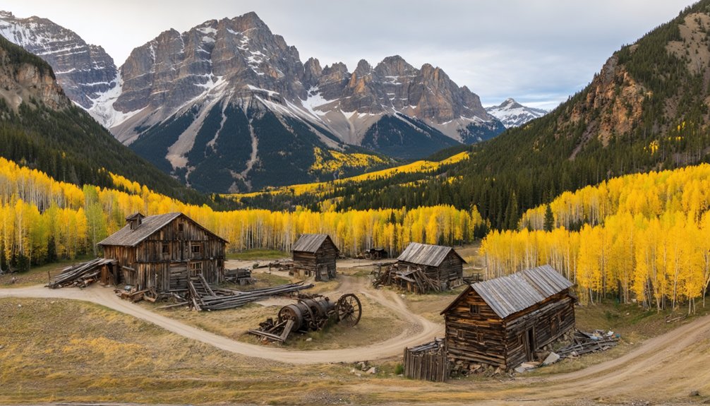
What You’ll Find: Original Structures and Modern Quirks
Stepping into Ophir feels like stumbling upon a time capsule that someone’s still living in—and that’s exactly what makes this ghost town so peculiarly alive. You’ll spot wooden house structures from the 1890s alongside modern cabins adorned with prayer flags and fences built from old skis. The original 1878 post office—a tiny split structure with 200 boxes—still stands, though it’s opened and closed more times than anyone’s counting.
What’s striking is the half-mile empty strip cutting through town: avalanche territory where nothing’s built. East and West Ophir sit separated, respecting the mountain’s destructive power that once pushed the mercantile 100 yards downslope. The avalanche chute can seal off the entire town for days, forcing locals to ski out of the valley when road access is impossible.
Today’s dog friendly neighborhood hosts roughly 50 houses and 51 dogs among 130-180 residents who’ve reclaimed this high-altitude haven at 9,800 feet.
Best Season to Visit This High-Altitude Ghost Town
Timing your visit to Ophir hinges entirely on what you’re willing to gamble against the San Juan Mountains’ mood swings. July through September offers ideal weather windows—start before 10 AM to dodge afternoon lightning on exposed switchbacks.
Late July brings wildflowers carpeting the alpine meadows, while September delivers photography opportunities with golden aspens blazing against weathered cabins. I’ve watched October storms gate the pass overnight, trapping vehicles on wrong sides of accumulation. Post-Labor Day thins the crowds considerably.
Check GMUG hotlines obsessively; this 11,789-foot crossing doesn’t forgive complacency. AWD remains non-negotiable for variable surfaces. Winter seals access November through June with drifts and avalanche debris. June’s muddy progression rewards solitude-seekers willing to navigate snowmelt streams and lingering snowfields into July.
The Ophir mining district once produced significant quantities of silver and gold, leaving behind structures that now serve as both destination and testament to high-altitude engineering ingenuity. Reaching the ghost town requires navigating Ophir Pass, where all-terrain tires prove their worth on loose rocks and unpaved surfaces that characterize this San Juan mountain crossing.
Exploring Beyond Town: Ophir Pass and Surrounding Trails
Beyond the weathered buildings of Ophir itself, you’ll find the namesake pass beckoning adventurers eastward toward Silverton—a moderately difficult 10-mile route climbing to 11,789 feet through stunning alpine terrain.
The western approach from town features narrow, rocky shelf roads that’ll test your nerves and your vehicle’s clearance, especially where the trail seems to blend into the mountainside itself. Plan your crossing between mid-June and early September when snow releases its grip, and you’ll discover why four-wheelers and hikers have traversed these San Juan ridgelines for centuries.
The surrounding San Juan National Forest provides ample opportunities for outdoor activities, from wildlife watching to photographing wildflowers against dramatic mountain backdrops. The route welcomes motorcycles and ATVs, making it accessible to various off-road enthusiasts exploring this unpaved mountain passage.
Ophir Pass Road Conditions
While Ophir itself sits tucked in a valley accessible by paved highway, the legendary Ophir Pass demands respect and proper preparation. Before you load your 4×4, check current pass closure notices—as of 2026, San Miguel County reports it’s closed due to deep mud and washouts.
When open (typically June through September), you’ll navigate a 10-mile route climbing to 11,789 feet, where the western descent turns into a single-lane shelf road with 300-foot drop-offs and zero guardrails.
Best driving practices for Ophir Pass include tackling it on weekday mornings before rental-Jeep traffic swarms the narrow sections. The eastern approach from Silverton offers wider terrain, while the western side demands careful throttle control and a spotter’s guidance through loose scree. Always yield to uphill traffic when meeting vehicles on these narrow shelf sections, as backing downhill on loose rock creates unnecessary risk.
Nearby Hiking Trail Options
Once you’ve conquered the pass or explored Ophir’s weathered cabins, the surrounding San Juan Mountains reveal dozens of trails that range from casual streamside walks to lung-burning alpine scrambles. The Ice Lake + Island Lake route stands out among iconic trail systems, curated by locals who know where the jaw-dropping vistas hide.
For shorter morning missions, try Bear Creek Falls or Wilson Meadows—both clock in under five miles. Columbine Lake Trail delivers scenic mountain overlooks through varied terrain across 10.5 kilometers of moderate climbing. Expert hikers can tackle the 8.44-mile challenges with five-plus-hour commitments.
The Uncompahgre RiverWay offers 42 miles of multi-use pathways if pavement suits you better. Pack raingear and water regardless—mountain weather shifts fast, and thunderstorms don’t care about your schedule.
Understanding the Avalanche Risk and Safety Considerations
You’ll find Ophir’s access road closes each winter when avalanche danger peaks—a necessary precaution since 70% of the three-mile route sits directly in the path of slides with 10-50 year return periods. The town itself has been partially evacuated multiple times throughout its history, and residents have learned to respect the buffer zones that separate homes from the most active avalanche paths.
When you visit during open seasons, you’re standing in one of North America’s most threatened inhabited valleys, where century-old scars from the early 1900s still mark where entire sections of the mining town were swept away.
Winter Closure and Evacuations
The snow-laden slopes surrounding Ophir close in on the town each winter like silent guardians turned threat, their avalanche paths covering roughly 70% of the three-mile access road with frightening regularity.
You’ll find the road shuttered from late fall through spring, when CAIC ratings climb to Moderate or Considerable danger levels. February 2025 saw a medium soft slab avalanche with a 1,300-foot-wide crown near the pass, prompting immediate emergency response coordination. This wasn’t exceptional—early 1900s slides devastated the mining town, forcing evacuations that became routine.
Today’s shelter planning reflects hard lessons: post-2008 construction stays in green zones only. You’re witnessing freedom balanced against nature’s raw power, where winter access means accepting genuine risk.
Buffer Zone Requirements
Survival in Ophir’s towering shadows hinges on understanding a color-coded map that dictates where you can—and absolutely cannot—build. Green zones mean freedom; yellow zones demand respect and permits; red zones? Forget it. These buffer zone regulations extend at least 100 feet around hazard areas, requiring special variances or permits before you hammer a single nail.
The 1974 study shaping these rules feels ancient to locals pushing for updated assessments. You’ll need impact assessment requirements proving your structure can withstand avalanche forces—think Vail’s stringent standards. Slopes exceeding 30 degrees create starting zones where snowpack releases without warning. Smooth terrain needs less snow depth to slide than rough ground, and those open forests won’t anchor anything when gravity decides it’s time to move mountains downhill.
Where Ophir Sits Among Colorado’s Historic Mining Communities
Nestled high in the San Miguel Mountains just eight miles from Telluride, Ophir occupies a precarious perch that once made it both strategic and vulnerable among Colorado’s mining settlements.
Perched precariously in the San Miguel Mountains, Ophir’s strategic elevation made it both valuable and vulnerable to Colorado’s harsh alpine elements.
Ophir’s unique position among Colorado ghost towns:
- Geographic accessibility – Unlike remote camps requiring multi-day pack trips, you’ll reach Ophir via maintained roads from a major resort town
- Living history – With 130 current residents, it’s evolved beyond static preservation into functioning residential properties and commercial developments
- Elevation extremes – Situated above 9,000 feet where avalanches once decimated structures in the early 1900s
- Revival timeline – While most mining towns stayed dead, Ophir’s 1972 resurrection coincided with Telluride’s ski boom
You’re visiting a rare hybrid: authentic mining heritage meeting modern mountain lifestyle.
Frequently Asked Questions
Are There Accommodations or Lodging Options Available in Ophir?
You’ll find cozy cabins and luxury lodges scattered throughout Ophir, from mountainside retreats with hot tubs to riverfront escapes. Most rentals start around $432 nightly, offering full kitchens, mountain views, and that off-grid freedom you’re craving.
Does Ophir Have Restaurants, Gas Stations, or Other Visitor Services?
You’ll find limited visitor services in Ophir—a few dog-friendly restaurants like Maggie’s and Smuggler Union Brewery serve meals near abandoned buildings. No gas stations exist here, but you’ll enjoy spotting local wildlife while exploring this authentic mountain ghost town.
Can You Visit the Historic Mine Sites Near Ophir?
You can explore several historic mining operations near Ophir, including accessible sites on National Forest land. You’ll discover old adits, tailings, and equipment while enjoying scenic mountain views, but use extreme caution around abandoned mine hazards.
Is the Post Office Open to Visitors for Mailing Services?
Unfortunately, you can’t mail anything from Ophir’s historic post office—no mailing services are available. However, you’ll find post office accessibility generous during post office hours: weekdays 9 AM-4 PM, Saturdays 9 AM-noon for PO Box holders.
Are There Guided Tours Available for Ophir’s History and Buildings?
While Ophir lacks guided walking tours through town itself, you’ll find extensive jeep tours exploring the area’s mining history. Self-guided walking maps aren’t formally available, but you can freely wander the historic streets discovering remnants independently.
References
- https://www.youtube.com/watch?v=hvnB5KmZtu4
- https://www.ghosttowns.com/states/co/ophir.html
- http://coloradosghosttowns.com/Ophir Colorado.html
- https://arc.lib.montana.edu/snow-science/objects/issw-1998-428-430.pdf
- https://www.coloradolifemagazine.com/blog/post/mountain-town-ophir
- https://www.uncovercolorado.com/towns/ophir/
- https://www.youtube.com/watch?v=APZJiri_E8M
- https://en.wikipedia.org/wiki/Ophir
- https://www.youtube.com/watch?v=cyQRFlXhwTk
- https://www.denvergazette.com/2022/06/19/starting-in-1858-heres-a-look-at-the-timeline-of-colorados-mining-past-20bc26e4-e4d3-5eae-8520-8fa197554111/


