
You’ll find Palo Alto’s remnants 0.3 miles west of Pruitt Road off Mississippi Route 47, where a historical marker and cemetery mark what once thrived as a bustling cotton trading hub. Plan your visit between November and April when comfortable temperatures make exploring ideal, and bring sturdy shoes, water, and insect repellent for the rural terrain. Extend your ghost town journey to nearby Rodney, Rocky Springs, Port Royal, and Princeton to discover Mississippi’s vanished settlements and the stories beneath their archaeological shadows.
Key Takeaways
- Access Palo Alto via Mississippi Route 47 through Clay County, with the marker located 0.3 miles west of Pruitt Road.
- Visit November through April for comfortable 60-70°F temperatures and lower humidity, avoiding hurricane season’s June-November uncertainties.
- Bring sturdy walking shoes, water, sunscreen, insect repellent, and a light jacket for unpredictable weather conditions.
- Explore the National Register-protected archaeological site where cotton warehouses and storefronts have become historical shadows.
- Extend your trip to nearby ghost towns including Rodney, Rocky Springs, Port Royal, and Princeton throughout Mississippi.
The Rise and Fall of a Mississippi Trade Town
Before the railroads redrew Mississippi’s economic map, Palo Alto thrived as a cotton trading hub in the flatlands of what would become Clay County. You’ll find its story etched in the 1846 founding, when warehouses, a carriage factory, and Palo Alto Inn served prosperous plantations. The antebellum architectural legacies include a Christian church and academy that anchored this 196-acre community, incorporated in 1852 and named for a distant Texas battlefield.
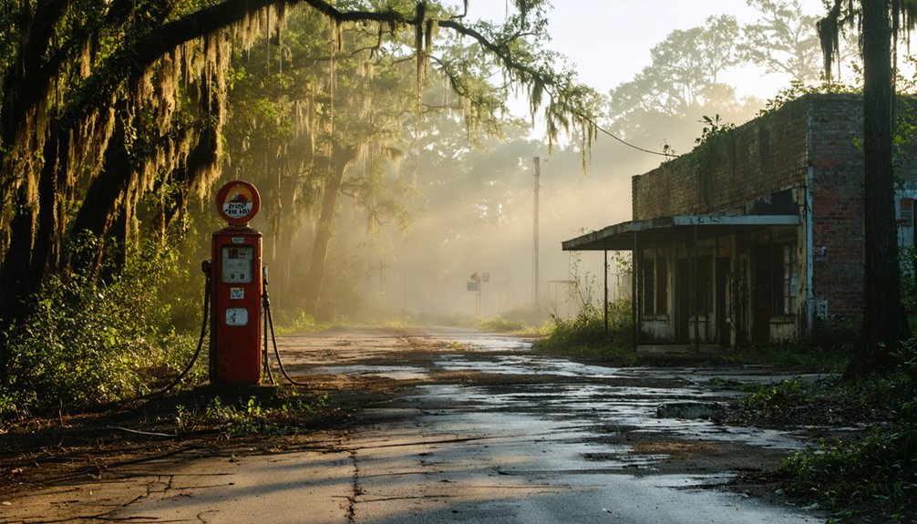
Post war economic shifts devastated the town’s independence. Trade routes pivoted toward West Point, draining Palo Alto’s lifeblood. By the 1880s, F.M. Abbott’s rival establishment absorbed what remained. Today you’ll discover the townsite on the National Register—a ghost settlement where one preserved house stands among decaying stores, beckoning archaeological exploration of Mississippi’s forgotten commercial crossroads.
Civil War Skirmish That Shaped Palo Alto’s Destiny
When Iowa cavalry thundered through Palo Alto in April 1863, they weren’t hunting a decisive battle—they were orchestrating a deception. Part of Grierson’s Raid, the 2nd Iowa Cavalry clashed with Tennessee soldiers here, creating enough chaos to mask Union movements elsewhere. Six cavalrymen vanished in the smoke.
The real devastation came at Okolona, where those same riders torched Confederate army buildings, ammunition depots, and cotton warehouses—gutting the supply infrastructure that sustained Southern forces. Confederate military influence ran deep in Palo Alto; Company F of the 44th Mississippi Infantry, “The Palo Alto Confederates,” had marched from here to Shiloh, Chickamauga, and beyond.
The skirmish’s economic devastation proved more lasting than its tactical impact, accelerating the town’s postwar collapse into dust.
What Remains: Cemetery and Archaeological Treasures
Today, Palo Alto exists as whispers in the earth—nearly 200 acres of National Register-protected ground where wooden storefronts and cotton warehouses have dissolved into archaeological shadows. You’ll find the cemetery standing north of the townsite, the most visible survivor of this 1840s trading center. Its weathered stones mark the boundary between memory and oblivion.
The historical significance runs deeper than headstones. Beneath your feet lies archaeological evidence spanning centuries—from de Soto’s 16th-century exploration to antebellum commerce to that violent 1876 voter suppression incident. Archaeologists recognize this site’s extraordinary potential, where every depression in the earth might reveal trade goods, building foundations, or fragments of daily life. You’re walking through layers of American experience, preserved precisely because progress passed this place by.
Getting There: Directions and Nearby Ghost Town Stops
Mississippi Route 47 cuts through Clay County farmland as your gateway to Palo Alto’s silent acres. You’ll find the marker 0.3 miles west of Pruitt Road, accessible via Highway 61‘s regional artery. The remote rural setting demands preparation—West Point, your nearest hub, offers general amenities nearby for fuel and supplies before venturing onto blacktop and dirt roads leading to these 196.4 acres of forgotten history.
Extend your journey beyond Palo Alto’s boundaries. Rodney ghost town awaits along Highway 61 near Lorman, where Mississippi River banks cradle a cemetery with graves from 1828.
Rocky Springs, Port Royal, and Princeton form additional waypoints for your ghost town circuit. Clay County’s depopulated sites cluster conveniently, allowing multi-location exploration across rural Mississippi’s haunted landscape within single-day striking distance.
Best Times to Visit and What to Bring

While Mississippi’s Gulf-influenced climate blesses Palo Alto with year-round accessibility, your ideal exploration window opens between November and April when temperatures hover in the comfortable 60-70°F range and humidity retreats from its suffocating summer grip. These months balance pleasant weather considerations with peak visitor seasons—you’ll encounter school groups flooding the mornings in May, so plan accordingly or embrace the afternoon calm when the Visitor Center opens at 1 pm.
Pack deliberately: sturdy walking shoes grip uneven terrain where history crumbled, while water and sunscreen counter Mississippi’s relentless sun. Toss in insect repellent and a light jacket for unpredictable winter mornings. The grounds welcome you daily from 8 am to 5 pm, but November through May brings increased rainfall—check forecasts before departing, and always avoid hurricane season’s June-November uncertainties.
Frequently Asked Questions
Are There Any Guided Tours Available for Palo Alto’s Historic Site?
No guided tours by local historians operate at Palo Alto’s remote site. You’ll explore this abandoned townsite independently, creating your own historical walking tours through overgrown ruins. It’s pure freedom—just you, coordinates, and Mississippi’s forgotten past waiting.
Is Camping Permitted Near the Palo Alto Townsite or Cemetery?
Camping isn’t permitted at Palo Alto’s townsite or cemetery under Mississippi’s 2025 law. You’ll need designated local camping options nearby while exploring. Review safety considerations and check Clay County’s authorized sites before your adventure into history’s shadows.
What Safety Precautions Should Visitors Take When Exploring the Ruins?
Wear proper safety gear including sturdy boots and gloves when exploring ruins. Avoid trespassing on private land—always seek permission first. Watch for unstable structures, contaminated soil, and sudden collapses. Travel with companions, stay alert, and respect all warning signs for your protection.
Are There Any Local Museums With Palo Alto Artifacts or Exhibits?
You won’t find dedicated Palo Alto exhibits nearby, but you’ll discover treasures through your local historical society and private artifact collections. These grassroots sources preserve authentic relics, letting you experience Mississippi’s forgotten past without institutional barriers.
Can Visitors Access Private Property Within the National Register Boundaries?
No, you can’t enter without permission. Access limitations protect landowners’ rights, and private land concerns mean you’ll face trespassing charges if you wander freely. National Register status doesn’t grant public entry—always respect posted boundaries.