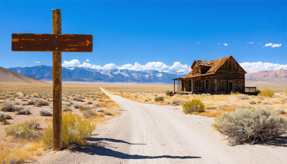
Navigate to coordinates 41.71875°N, 113.34502°W in Box Elder County’s remote northwestern corner, where you’ll find the haunting remnants of Russian Settlement’s failed 1914 Molokan colony. You’ll need a reliable vehicle for the 6.6-mile gravel approach from Park Valley, plus downloaded offline maps since cell service doesn’t exist out here. Pack plenty of water and prepare for absolute solitude as you explore the white-picketed cemetery with its Cyrillic headstones and faint building foundations. The complete story behind this three-year tragedy awaits your discovery.
Key Takeaways
- Navigate to coordinates 41.71875°N, 113.34502°W in Box Elder County, northwest of Park Valley via gravel roads.
- Pack water, fuel, and download offline maps as this remote desert location has no services or permanent residents.
- Visit the cemetery at 41.71693°N, 113.35060°W to see Russian-inscribed headstones within a white picket fence.
- Few structures remain from the 1914-1918 settlement, though faint building patterns are visible in certain light.
- Best accessed from Tremonton or Park Valley; expect 6.6 miles of final approach on gravel roads.
The Tragic Story Behind Russian Settlement’s Founding in 1914
In 1914, a group of about 100 to 125 Russian Spiritual Christians—mostly Molokans known as pryguny, or “Jumpers”—made a desperate gamble that would end in heartbreak. After a decade in Los Angeles, these Protestant-like believers watched their children slip away to American influences. The elders feared language loss and saw their tradition of arranged marriages crumbling amid scandalous “bride-selling” court cases.
Seeking isolation, twenty men purchased four square miles of Box Elder County land sight unseen for $17.50 per acre. When families arrived by train and wagon that April, they found barren desert—not the promised paradise. Most turned back immediately. The thirty families who stayed built their village at Russian Knoll’s base, only to face tragedy within weeks when Anna Kalpakoff died from an accidental shooting. The Pacific Land and Water Company had promised to provide water but failed to deliver, sealing the colony’s fate from the start.
Why the Molokan Dream Colony Failed Within Three Years
Before the Russian settlers could even unpack their belongings, the Pacific Land and Water Company’s promises began unraveling like cheap burlap in the desert sun. You’ll discover that land fraud schemes destroyed this colony through four devastating failures:
The Pacific Land and Water Company’s grand promises dissolved like mirages before desperate Russian families could establish roots in Utah’s harsh desert.
- Deceptive Sales Tactics – Speculators charged $17.50 per acre while grossly exaggerating water availability and soil quality
- Broken Infrastructure Promises – Facilities needed for survival never materialized, leaving families stranded
- Brutal Environmental Challenges – Starting in 1915, repeated droughts turned crops to dust in Box Elder County’s unforgiving desert. The Molokans, accustomed to traditional linear street villages in Russia’s Volga region, found themselves unable to replicate their communal farming lifestyle in this isolated landscape.
- Impossible Living Conditions – Without adequate water, harsh weather, and poor soil made agriculture futile
Finding Russian Settlement: Directions and Coordinates
Today’s landscape offers few clues to the suffering that unfolded here, but you can still locate the remnants of this failed colony with precise coordinates. Navigate to 41.71875°N, 113.34502°W in Box Elder County‘s vast openness, northwest from Park Valley. Your GPS will guide you to 4,849 feet elevation where legal boundary descriptions mark Section 13, T9S, R9W—the surveyor’s language that once defined homestead dreams.
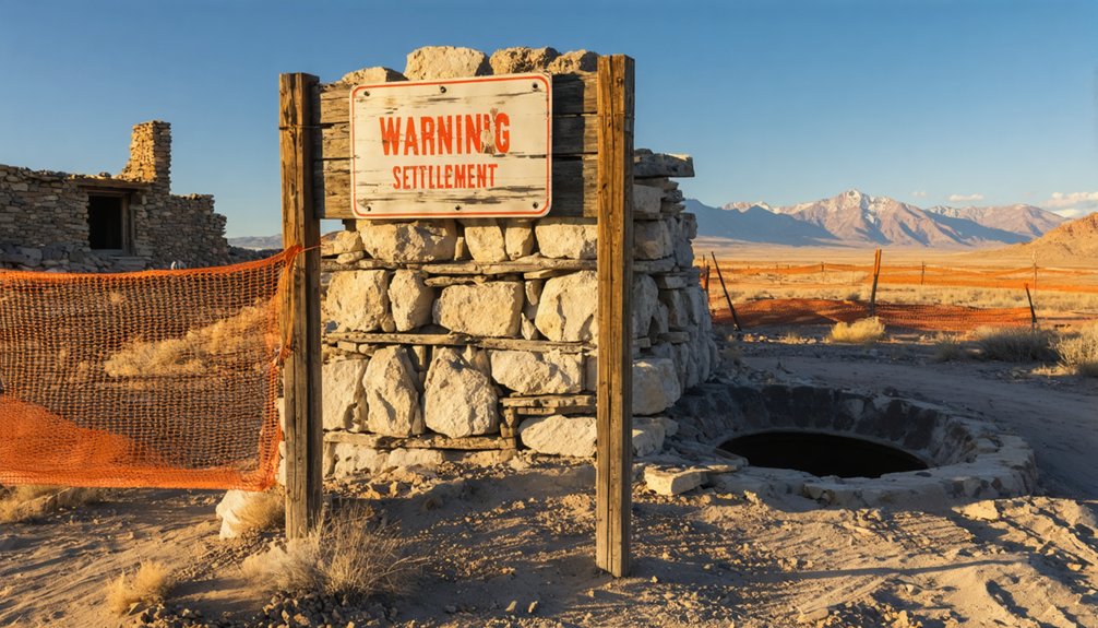
The Russian Settlement Cemetery (41.71693°N, 113.35060°W) serves as your primary landmark for site orientation. This modest two-grave burial ground stands as the colony’s most tangible reminder. You’ll need reliable coordinates since roads barely exist out here. The site appears on the USGS Russian Knoll topographic map, providing additional navigation reference for backcountry explorers. German colonists settling Russian territories in the early 1800s received exemption from taxes for their first ten years, though Utah’s Russian Settlement emerged under different circumstances decades later. Pack water, download offline maps, and embrace the solitude. This remote corner of Utah rewards those who venture beyond maintained routes.
What You’ll Discover at the Abandoned Site Today
When you arrive at Russian Settlement’s windswept coordinates, you’ll find a landscape that’s been stripped nearly bare by time and salvagers. Box Elder County locals hauled away nearly every structure decades ago, leaving precious few modern day markers of this failed utopian dream.
What remains for exploration:
- The white picket fence encircling two graves with Russian-inscribed headstones—including Anna Kalpakoff’s tragic marker
- Faint building patterns and town lot outlines visible in certain light conditions
- Desert-reclaimed farmland where Molokan families battled drought and deception
- Absolute solitude with no permanent residents since 1918
These documented artifacts tell a powerful story of perseverance against impossible odds. The settlement, established in 1914 by Russian Christians seeking affordable land near Park Valley, lasted only three years before repeated crop failures forced residents to abandon their dream. Bring water, respect the graves, and let your imagination reconstruct what once stood here.
Exploring the Cemetery and Russian-Inscribed Headstones
You’ll find the cemetery a half-mile east of Russian Knoll, marked by a weathered white picket fence protecting two graves with Russian-language inscriptions. When I visited, I parked near the old settlement site and walked the short distance—bring water and wear sturdy boots since there’s no maintained trail.
The headstones, replaced in 1966 by Mary Kalpakoff’s descendants, stand as the only intact remnant of this failed utopian colony, their Cyrillic letters still legible against the stark Utah landscape.
Cemetery Location and Access
The Russian Settlement cemetery sits at a remote crossroads of tragedy and history, marked by N41.71875° W113.34502° at 4849 feet elevation on the windswept plains of Box Elder County. You’ll find this remote location on the USGS Russian Knoll topographic map, surrounded by native plant life and silence.
Getting There:
- From Park Valley: Head south on Board Ranch Road for 10 miles, then turn west toward Russian Knoll
- From Tremonton: Take I-84 northwest to Highway 30 west of Snowville, continue to Park Valley
- Final Approach: Turn east at State Highway maintenance buildings, drive southeast on gravel for 6.6 miles
- Landmark: Cemetery sits one-half mile east of Russian Knoll hill
Bring GPS coordinates—cell service won’t help you here. For those planning to document their visit, contributors have added 4 photos to the Find a Grave database, though the cemetery accepts a maximum of 20 total photographs.
Preserving Historic Grave Markers
Standing before the weathered white picket fence, you’ll immediately notice what makes this cemetery extraordinary—two headstones inscribed entirely in Russian Cyrillic script, their letters still remarkably legible after decades of high-desert winds and winter snows. The descendants showed remarkable foresight when they replaced the original 1915 markers with new stones in 1966, selecting gravestone material quality that could withstand Utah’s brutal temperature swings.
These markers honor Anna and Mary Kalpakoff, the settlement’s final residents. The protective fence represents basic but effective gravestone preservation techniques—shielding the bases from erosion while allowing airflow. You’re witnessing frontier history most Americans never knew existed. The cemetery sits in a waterless desert landscape, accessible only by navigating a network of unmarked dirt roads miles from civilization. Located four miles west of US Highway 89 along a gravel road, the site requires permission to visit as the surrounding area serves as cattle grazing land. Photograph the Cyrillic inscriptions respectfully; they’re irreplaceable artifacts connecting this remote sagebrush corner to Russia’s religious dissenters who dared dream of freedom.
The Original Village Layout Along the Central Street
When Russian immigrants first surveyed their new homeland in 1914, they laid out a main street running east to west—a design pulled straight from the row villages they’d left behind in the Empire. This central axis organized everything, with uniform house frontages creating a cohesive settlement pattern you can still trace today.
A single street running east to west—transplanted Empire design organizing an entire community through familiar geometry.
The layout’s key features included:
- Lot widths of 200 feet providing each family three acres stretching perpendicular to the street
- Houses positioned close to the road with barns and outbuildings further back
- A schoolhouse anchoring the west end while a cemetery marked the eastern boundary
- Wells and root cellars dug throughout for self-sufficiency
Though abandoned by 1918, these lot patterns remained visible through the 1960s—evidence of determined pioneers carving freedom from harsh land.
Preparing Your Vehicle for the Remote Desert Terrain
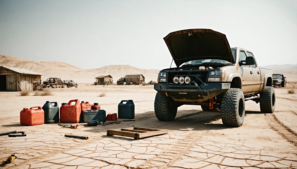
Your vehicle needs true 4WD capability—not just all-wheel drive—to handle the sagebrush flats and loose gravel trails leading to Russian Settlement’s remnants at 41°43′N 113°21′W.
You’ll face intermittent crossings near Dove Creek where water flow varies seasonally, so scout each ford carefully before committing your undercarriage to unknown depths.
Watch for hidden hazards around crumbling stone foundations and partially buried debris from the 1914-1918 settlement, which can puncture tires or damage your vehicle’s belly if you’re not scanning the ground constantly.
Essential 4WD Capabilities
Before you venture down the washboard roads leading to Russian Settlement, you’ll need to understand what separates a capable desert 4WD from a vehicle that’ll leave you stranded twenty miles from the nearest cell tower.
Your rig needs these core capabilities:
- Low-range transfer case – Essential for crawling over embedded rocks and maintaining control on steep descents without cooking your brakes.
- All-terrain tires – Aggressive tread patterns deliver tire traction through sand, gravel, and slickrock sections you’ll encounter. Verify your tires have tread depth of at least 5/32 inch to ensure adequate performance on variable terrain.
- Skid plates – Undercarriage protection shields your oil pan, transmission, and fuel tank from hidden obstacles lurking beneath sandy washes.
- Extended fuel range – Calculate 200+ mile capability; gas stations disappear fast out here, and rough terrain devours fuel at surprising rates.
- Current registration – If you’re bringing an out-of-state OHV, you’ll need a non-resident permit to legally operate on Utah’s off-highway trails and access roads leading to remote destinations like Russian Settlement.
Between Russian Settlement and civilization, Dove Creek cuts across the access road at least twice—and I learned the hard way that these intermittent streams don’t forgive careless crossings. Flash floods transform these dusty trenches into torrents within minutes, catching unprepared explorers off-guard.
Check weather forecasts for Box Elder County, avoiding trips after rain. At each crossing, step out and probe the streambed depth with a stick—hidden washouts lurk beneath innocent-looking surfaces. Seasonal stream fluctuations mean August’s dry path becomes October’s muddy trap.
Commit to first gear, maintaining steady momentum without stopping mid-crossing. Choose rocky sections over sand where possible. If water’s flowing above your axles, wait it out. That abandoned settlement survived harsh conditions; you’ll survive patience better than a stranded vehicle.
Hazard Awareness Around Foundations
Three crumbling stone foundations mark where Molokan families once carved existence from this unforgiving desert—and they’re waiting to damage your vehicle or worse.
Those 3-acre lots with their 200-foot main street frontages hide deadly secrets beneath the sagebrush. In 1937, a cowboy on horseback plunged into a concealed well, barely escaping with his life. You’re exploring the same ground.
Foundation Zone Safety Protocol:
- Park 50+ feet from visible foundations—root cellars and barn remnants extend underground unpredictably
- Use careful foot placement when approaching structures—test ground stability with a walking stick first
- Mark discovered wells immediately with bright flags to prevent well collapse risks during return trips
- Never drive between foundation clusters—hidden outbuilding bases will destroy your undercarriage
Freedom means respecting what broke these determined settlers.
Safety Considerations When Visiting Old Foundations and Wells
When you’re exploring the weathered foundations and gaping wells of ghost towns like Russian Settlement, you’ll quickly realize these crumbling structures pose serious dangers that don’t announce themselves with warning signs. Those rotten floorboards won’t hold your weight—I’ve watched seasoned explorers nearly plunge through seemingly solid planks.
Loose debris hazards lurk everywhere: rusted nails, broken glass, and asbestos fragments from collapsed roofs. Structural collapse dangers intensify near deteriorating walls and unstable beams ready to give way without warning.
Before you venture near any foundation or open pit, test every surface with your trekking pole first. Stay alert for hidden trenches camouflaged by overgrowth. Keep your distance from open wells—they’re unmarked death traps. Document your route, carry emergency communication devices, and never explore alone in these remote locations.
Best Times of Year to Visit Northwestern Utah’s Ghost Towns
You’ll find spring (March-May) and fall (September-November) offer the sweet spot for exploring Russian Settlement, with temperatures ranging from the 40s to mid-70s that make wandering through crumbling foundations comfortable rather than grueling.
I’ve learned the hard way that summer’s extreme heat doesn’t just drain your energy—it brings flash flood risks to northwestern Utah’s low-lying areas, turning dusty paths into dangerous channels within minutes.
Winter drops visitor numbers dramatically and brings heavy snowfall to northern elevations, though the Russian Settlement area itself rarely sees snow stick at its lower elevation.
Seasonal Weather Considerations
Northwestern Utah’s ghost towns reveal themselves differently across four distinct seasons, each offering unique advantages and challenges for exploration. You’ll need to match your adventure timing with what matters most to your journey.
Seasonal Planning Guide:
- Spring (April-May) brings comfortable hiking temperatures around 64°F-74°F with moderate average monthly precipitation at 2.03 inches—perfect for photography as wildflowers emerge around abandoned structures.
- Summer (June-August) offers dry conditions but punishing 92°F-93°F heat that’ll drain you quickly in exposed areas.
- Fall (September-October) delivers ideal exploration weather before November’s chill sets in, with changing leaves framing weathered buildings.
- Winter (December-February) creates dramatic scenes but expect freezing temperatures, limited daylight, and potentially impassable roads requiring serious preparation.
Avoiding Flash Flood Dangers
Flash floods transform peaceful desert washes into deadly torrents within minutes, and while much of Utah’s documented flooding occurs in the southern slot canyons near Zion, northwestern Utah’s ghost towns aren’t immune to these sudden deluges. You’ll want to time your Russian Settlement exploration for late spring through early fall, avoiding peak monsoon season in July and August when afternoon thunderstorms develop rapidly.
Before heading out, check weather forecasting for the entire region—storms 50+ miles upstream can send floodwaters racing through seemingly dry areas hours later. I’ve learned to monitor conditions from the previous day too, since late-evening precipitation can arrive the following morning. Install flash flood monitoring apps and avoid low-lying washes during active weather patterns. Your freedom to explore depends on respecting nature’s unpredictable power.
Nearby Attractions and Other Park Valley Area Sites
While Russian Settlement itself offers a fascinating glimpse into pioneer history, the surrounding Park Valley area beckons with an impressive array of natural wonders and historical landmarks that’ll transform your ghost town visit into a multi-day adventure.
As you explore the ghost town history of Russian Settlement, be sure to visit the remnants of early structures that tell tales of resilience and community. The rich narratives etched in the landscape are complemented by vibrant flora and fauna that thrive in the area, creating a stark contrast to the desolation of the past. Each site offers a unique perspective, inviting visitors to ponder the lives once lived and the stories waiting to be discovered.
Essential stops worth exploring:
- City of Rocks National Reserve – These unique rock formations create a climber’s paradise with granite spires reaching skyward, plus camping spots for overnight freedom.
- Castle Rocks State Park – Discover hoodoos and backcountry camping opportunities among diverse granite landscapes.
- Durfee and 12 Mile Hot Springs – Soak weary muscles in these nearby hot springs after dusty explorations (dirt road access required).
- Spiral Jetty and Golden Spike National Historical Park – Experience Robert Smithson’s earthwork masterpiece and witness transcontinental railroad history with replica locomotive demonstrations.
Frequently Asked Questions
Are There Any Camping Facilities Near Russian Settlement?
You’ll find limited infrastructure nearby, but that’s part of the adventure! Remote camping options exist on surrounding BLM land, offering primitive camping availability. You’re free to explore independently, though you’ll need total self-sufficiency for this backcountry experience.
Can I Take Artifacts From the Site as Souvenirs?
No, you can’t take artifacts—it’s illegal under federal and state law. The legality of artifact removal carries serious penalties, and souvenir collection creates environmental impact by destroying irreplaceable historical context. Photograph memories instead; they’re yours to keep forever.
Is Permission Required to Visit Russian Settlement?
No formal permits are needed, but you’ll want to check private property concerns since 60% of ghost towns sit on private land. Respect local regulations enforcement and ask nearby ranchers before exploring—freedom comes with responsibility.
Are There Restroom Facilities Available at or Near the Site?
No restroom facilities exist at this remote ghost town. You’ll need to plan ahead—stop in Park Valley beforehand. There’s no availability of drinking water either, and nearby lodging options are miles away, so come prepared for rugged, self-sufficient exploration.
What Cell Phone Coverage Can I Expect in This Area?
Cell phone signal strength vanishes, network coverage availability disappears, and you’ll find yourself truly off-grid. Download offline maps beforehand, pack a satellite communicator, and embrace the liberating silence of complete disconnection in this remote valley.
References
- https://www.familysearch.org/en/wiki/Russian_Settlement
- https://kids.kiddle.co/Russian_Settlement
- https://www.youtube.com/watch?v=sc9PUNK4ILo
- https://www.molokane.org/places/USA/Utah/index.html
- https://www.valleyjournals.com/2024/10/02/507818/exploring-utah-s-ghost-towns-seven-abandoned-settlements-with-fascinating-histories
- https://history.utah.gov/repository-item/russian-molokans-in-utah-a-conversation-with-marshall-bowen-summer-2015/
- http://www.expeditionutah.com/forum/index.php?threads/ghost-town-russian-settlement.6395/
- https://en.wikipedia.org/wiki/Russian_Settlement
- https://www.youtube.com/watch?v=VopFXih6lOM
- https://digitalcommons.humboldt.edu/cgi/viewcontent.cgi?article=1000&context=histpaper


