You’ll find Shiawasseetown 30 miles northeast of Lansing at coordinates 42°55’46″N 84°04’46″W, accessible via I-69 and M-71 highway. This ghost town served as Michigan’s capital for just one day in 1847 before nature reclaimed its 90 platted blocks. Today, the crumbling Shiatown Dam and overgrown foundations mark where frontier ambition met silence. Pack all supplies—there’s no gas station or restaurant in this windswept territory where 2,740 township residents guard stories of what might have been.
Key Takeaways
- Located 30 miles northeast of Lansing at coordinates 42°55’46″N 84°04’46″W, accessible via Interstate I-69 and M-71 highway.
- No modern amenities available; plan accordingly as there are no gas stations, restaurants, or stores in the settlement.
- Main attractions include the historic Shiatown Dam, millpond fishing area, and overgrown ruins of 1840s taverns and mills.
- Visit nearby Shiawassee County Historical Museum to view photographs documenting the dam’s operational history and settlement era.
- Bancroft village at 42°52’43″N 84°03’50″W serves as the nearest gateway community for supplies and accommodations.
The Rise and Fall of Michigan’s Lost Capital Dream
On March 15, 1847, the unassuming settlement of Shiawasseetown achieved what no other Michigan town would before or since—it became the state capital for exactly one day.
This bizarre footnote emerged from intense political squabbling over relocating Michigan’s government from Detroit. Ann Arbor, Jackson, Grand Rapids, and Marshall all competed fiercely through civic boosterism, with Marshall’s officials even constructing a governor’s mansion in anticipation of victory.
Enter Senator Joseph H. Kilbourne, who championed the nearly uninhabited Lansing Township as a compromise. Yet Shiawasseetown briefly claimed the designation on March 15 before Lansing secured permanent status the following day.
Today, you’ll find only a weathered monument marking this peculiar legacy—a commemoration of ambition that flickered and died within twenty-four hours.
What to Expect When You Arrive at This Hidden Village
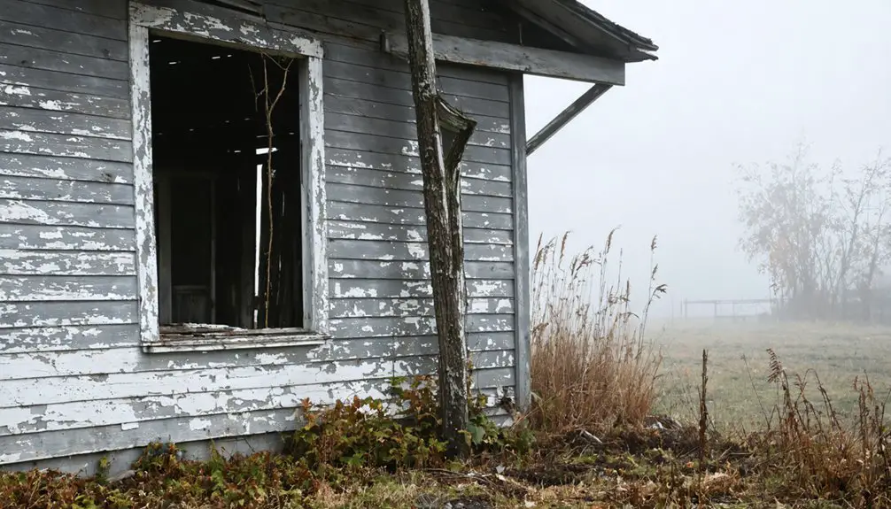
When you pull off at the junction of Bancroft and Bennington roads, you’ll find yourself in a settlement that exists more as historical whisper than functioning village. This undiscovered community charm reveals itself through remnants of 90 platted city blocks now reclaimed by nature and the Shiatown Dam’s millpond reflecting sky through ancient trees.
Don’t expect modern conveniences—there’s no gas station, restaurant, or store. You’re truly off-grid here, so pack provisions. The Shiawassee River, meaning “Sparkling Waters,” flows past crumbling foundations where taverns and mills once thrived. Local resident perspectives paint pictures of five drownings in twenty years and a dam inspectors deemed dangerously deteriorated. Yet 2,740 souls call this township home, maintaining their quiet existence away from curious travelers seeking Michigan’s forgotten places.
Getting There: Directions and Coordinates
Your journey to Shiawassee Township begins approximately 30 miles northeast of Lansing, where coordinates 42°54′02″N 84°05′17″W mark this 36.85-square-mile expanse of forgotten history. You’ll navigate Interstate I-69 and M-71 highway to reach this windswept territory where coordinate accuracy becomes essential—modern GPS sometimes struggles with settlements that barely exist on current maps.
Shiawasseetown itself sits at 42°55′46″N 84°04′46″W, near the intersection of Bancroft and Bennington roads. You’ll find Bancroft village at 42°52′43″N 84°03′50″W in the township’s southeast section, serving as your gateway community.
Notable township landmarks include Grand River Road and the Newburg crossroads. The terrain spans 36.39 square miles of land at 794 feet elevation, where abandoned homesteads and weathered structures await those willing to venture off the beaten path.
The Historic Shiatown Dam and Its Troubled Legacy
Rising from the banks where “Sparkling Waters” earned their Native American name, the original Shiatown dam emerged in 1840 as a monument to frontier ambition—a wooden barrier harnessing the Shiawassee River’s current for water-powered industry.
Where ancient “Sparkling Waters” flowed free, frontier dreamers built their wooden monument to progress and industrial transformation.
By 1904, engineers replaced it with hydroelectric infrastructure, chasing electric dreams that never materialized. You’ll find only remnants now—the reservoir choked with a century’s silt accumulation, rendering recreation impossible and power generation futile.
Economic challenges doomed every company that attempted revival. Through the 1970s it passed from county hands to would-be entrepreneurs, each failing profitability tests. By 1999, unpaid taxes returned it to Michigan’s custody.
Environmental degradation sealed its fate. The State began dismantling this hazardous relic in 2012, liberating the river from industrial bondage.
Exploring the Remaining Landmarks and Ruins
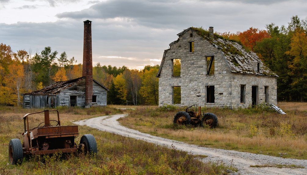
You’ll find the Shiatown Dam standing as the most tangible remnant of this vanished settlement, its weathered structure still controlling the Shiawassee River’s flow. The millpond it created spreads behind the dam, now serving as a quiet recreation area where fishermen cast lines over what were once the bustling waterways of commerce.
Search the overgrown banks and you’ll discover original settlement site markers, barely visible stones and foundations that hint at the homes and businesses that lined these shores in the 1800s.
The Historic Shiatown Dam
Though surrounded by overgrown brush and marked by decades of neglect, the Shiatown Dam stands as the most substantial reminder of Shiawassee Township’s ambitious industrial past. You’ll find this mid-1800s engineering marvel near Bancroft and Bennington roads, where it once powered the township’s sawmill, flour mill, and carding mill simultaneously. The weathered foundation elements reveal period-appropriate construction techniques that supported an entire commercial ecosystem.
Today, you’re free to explore the accessible ruins without crowds or tourist infrastructure—just authentic history waiting at the park and canoe launch. While dam restoration efforts remain unlikely, adaptive reuse opportunities could transform this site into a meaningful educational destination. The Shiawassee County Historical Museum preserves photographs documenting the structure’s functional era, offering context for your exploration.
Millpond and Recreation Area
Where the Shiawassee River once pooled behind the historic dam, Fenton’s four-acre Millpond Park now serves as the recreational heart of downtown, transforming industrial heritage into accessible public space. You’ll find this free-access park open year-round, offering unrestricted exploration along the riverbanks where industry once dominated.
The amenities offered cater to varied interests:
- Fishing access directly into the Shiawassee River’s flowing waters
- Rental gazebo available in four-hour blocks ($150-$200 plus deposit)
- War memorial honoring those who served
Beyond these permanent features, seasonal event programming includes Thursday night Concert in the Park series throughout summer. The adjacent Shiawassee Riverwalk connects you to three additional parks—Strom, O’Donnell, and Community Center Rackham Park—creating an interconnected network where Shiatown’s industrial past meets present-day recreational freedom.
Original Settlement Site Markers
Along the Shiawassee River‘s winding course through central Michigan, scattered remnants of the region’s earliest settlements tell stories that predate the ghost town by decades—some by millennia.
You’ll find historic trading post markers where Henry Bolieu established temporary operations in 1816, following canoe routes the Ojibwe used for centuries. Archaeological evidence uncovered at Battle Point reveals trade goods—silver ornaments, glass beads, firesteels—from the Ottawa burial grounds that once overlooked the river.
Near Chesaning, Big Rock‘s ceremonial meeting place stood until 1841, when navigation improvements erased this sacred Ojibway and Ottawa landmark. At Owosso, Chief Wosso‘s summer residence featured corn fields and apple orchards tended without plows, marking where indigenous peoples cultivated the land long before European settlement transformed the landscape forever.
Best Times to Visit for Photography and Exploration

You’ll capture Shiawassee Town’s haunting beauty best during golden hour—that magical window when low-angled sunlight transforms weathered foundations and mill ruins into textured masterpieces glowing amber and gold. Your timing matters beyond just light: spring and fall offer comfortable 50-70°F temperatures for extended hikes, while wildlife activity peaks during summer mornings and autumn migrations, adding dynamic elements to your compositions.
Plan visits around seasonal shifts—mid-October’s vibrant foliage creates stunning contrasts against faded structures, and winter’s snow blankets the ghost town in ethereal silence perfect for moody black-and-white photography.
Golden Hour Light Conditions
- March: Catch sunrise golden hour from 7:00-7:30 AM, sunset from 6:45-7:45 PM
- June: Extended 45-minute pre-sunrise window starting at 5:15 AM, sunset lasting until 9:15 PM
- Autumn: Peak 60-minute sunset golden hour for maximum exploration time
The diffused light reduces contrast, flattering your wide-angle shots of the 1837 town square while long shadows from schoolhouses create compelling compositions.
You’ll enjoy enhanced trail visibility and a comfortable 2-hour window combining photography with unfettered exploration.
Seasonal Weather Considerations
Michigan’s dramatic seasonal swings transform Shiawassee Town from a snow-blanketed winter landscape averaging 39 inches annually to sun-drenched summer days peaking at 82°F in July. You’ll find ideal exploration windows from May through October, when temperatures range between 54°F and 84°F.
Winter’s snowy hazardous conditions—with January lows hitting -9°C—restrict access and visibility. Milder spring weather impacts include muddy trails during thaws, though 172 annual sunny days provide ample photography opportunities.
Summer delivers low humidity and extended daylight for documenting abandoned structures, while fall’s crisp air sharpens your shots during foliage peaks. Plan around 124 precipitation days yearly, but don’t let weather forecasts confine you—unexpected conditions often yield the most haunting images of this forgotten settlement.
Wildlife Activity Patterns
Beyond weather patterns, the wildlife calendar dictates your most rewarding exploration windows at Shiawassee Town. Early morning bird hunts starting at 5:00 a.m. capture nature at its most dynamic, while afternoon waterfowl photography sessions beginning at 11:00 a.m. align with peak activity periods.
Prime viewing opportunities include:
- Late October – Experience sky-filling flocks of up to 40,000 ducks and 25,000 Canada geese during peak migration
- Spring-summer trails – Encounter nesting eagles, white-tailed deer, and eastern fox snakes along accessible pathways
- Fall concentrations – Witness over 100 songbird species and the highest raptor diversity of the year
With over 280 migratory species documented annually and year-round marsh access via managed dikes, you’ll discover unrestricted wildlife encounters that reward spontaneous exploration and patient observation.
Essential Supplies: Pack Your Own Food and Gas

When planning your ghost town road trip to Shiawassee Town, you’ll need to embrace complete self-sufficiency—this remote village offers no restaurants, gas stations, or convenience stores to bail you out.
Fill your tank before reaching the Bancroft-Bennington junction, as fuel services vanish beyond this point. Water considerations demand priority: stock ample bottles for outdoor exploration around the dam and kayak launch.
Your packing recommendations should include portable meals, non-perishable snacks, and a well-stocked cooler for extended wandering through this forgotten landscape.
This hidden Shiawassee Township destination rewards prepared adventurers. Load your vehicle with picnic supplies, backup fuel containers, and provisions matching your intended stay.
The freedom to explore this authentic ghost town comes with responsibility—you’re venturing into genuine backcountry where historical decline eliminated modern conveniences entirely.
Safety Considerations for Visiting the Dam Area
The Shiawassee Town dam demands your utmost respect and caution—this aging structure harbors dangers that have claimed lives on similar installations throughout the region. Since the 1950s, structural degradation has created hazardous conditions, while environmental remediation efforts continue addressing PCB contamination exceeding 3.37 ppm in nearby sediments.
Before exploring this ghost town landmark, heed these boating safety recommendations:
- Always wear your PFD—Michigan law mandates properly fitted life jackets for all watercraft users
- Never approach the dam—low-head hydraulics create deadly backwash that traps even experienced paddlers
- Tell someone your plans—share your exact location and expected return time
Watch for submerged branches, unpredictable currents, and unmarked hazards. The dam’s deteriorating condition makes portaging around it absolutely essential for survival.
Nearby Towns Worth Adding to Your Route
Your ghost town exploration naturally pairs with Shiawassee County’s vibrant communities, each offering distinct attractions that transform a quick visit into a memorable journey. Owosso, the county’s largest city with 14,658 residents, showcases the Steam Railroading Institute and historic town architecture that contrasts beautifully with abandoned commercial buildings you’ll encounter elsewhere.
Corunna, the county seat, delivers downtown shopping amid preserved structures along the Shiawassee River. Durand’s Union Station stands as a railroad landmark worth photographing, while Perry offers agricultural authenticity with its 4.09 livability rating. Laingsburg provides rural charm near Clinton County’s border. Each stop adds depth to your ghost town adventure, revealing how Michigan’s small communities preserve history while abandoned sites slowly fade into memory.
Outdoor Activities: Kayaking and Canoeing the Shiawassee River
Paddling the Shiawassee River transforms your ghost town exploration into a waterborne adventure, where narrow channels wind past abandoned structures and forgotten riverside settlements inaccessible by road. Before launching, you’ll need to understand paddler safety requirements—Michigan law mandates PFDs for everyone aboard, and you should check real-time flow conditions through the Shiawassee watershed monitoring system.
Essential preparation includes:
- Scouting portage routes around unmarked dams that pose deadly hazards
- Establishing emergency communication protocols by informing others of your launch location and expected return
- Monitoring preferred flow rates between 150–400 CFS for safe navigation
Late spring offers steadier currents for discovering these hidden riverside remnants. The Keepers of the Shiawassee Facebook page connects you with local paddlers who know which channels reveal the most intriguing ghost town perspectives.
Frequently Asked Questions
Is Overnight Camping Permitted Near the Dam or Millpond Area?
No overnight camping is allowed near the dam or millpond area, but you’ll find hiking trails nearby where you can explore freely during daylight hours. Respect posted regulations while discovering this historic ghost town’s natural beauty.
Are There Any Guided Tours Available for the Ghost Town?
You won’t find structured ghost town tours here—this landscape whispers its secrets independently. Instead, you’ll discover self-guided walking tours with historical interpretive signage throughout the area, letting you explore Shiawassee’s forgotten stories at your own adventurous pace.
Can I Access Historical Records or Maps of the Original 90-Block Plan?
You can explore the 1859 Geil & Jones map through the Library of Congress, featuring historical land surveys by Stout, Nash, and Wilson. Old-Maps.com offers reproductions, while abandoned building archives reveal Shiawassee Town’s original settlement layout and property details.
Is Cell Phone Reception Reliable in the Shiawassee Town Area?
You’ll find surprisingly strong reception despite the “ghost town” mystique—no weak cellular coverage here. All major carriers provide 100% 4G LTE service, with Verizon offering 83% 5G coverage and T-Mobile delivering impressive speeds, ensuring you’re never disconnected from civilization.
Are Pets Allowed at the Park and Canoe Launch Areas?
Pets aren’t allowed on refuge trails or grounds under current pet policies. However, you can bring your canine companion in your vehicle on Wildlife Drive. Picnic area regulations prohibit animals, though bank fishing spots along the river remain accessible.