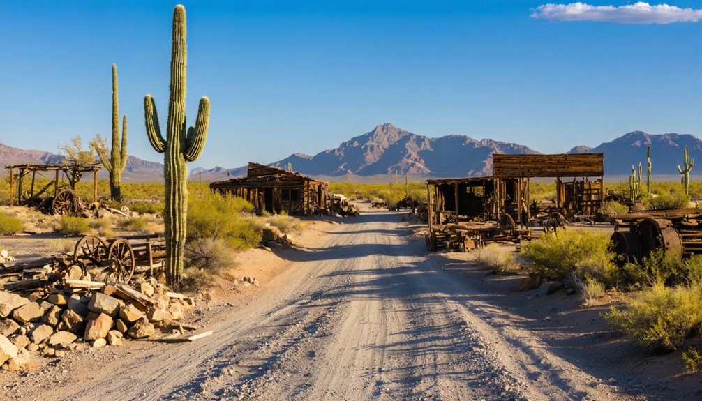
You’ll find Signal 16 miles off U.S. Route 93, where weathered foundations and skeletal mine structures mark where 800 prospectors once crowded into 13 saloons during the 1870s silver boom. The journey requires high-clearance vehicles and careful timing—Big Sandy River shifts from gentle trickle to impassable torrent without warning. Navigate by Artillery Peak’s 2,917-foot silhouette, but pack emergency supplies since you’re venturing into genuine isolation where help isn’t coming quickly. The ruins reveal secrets that reward those who come prepared.
Key Takeaways
- Access Signal via Signal Road, located 16 miles off U.S. Route 93, approximately 60 miles south of Kingman in Arizona.
- Monitor Big Sandy River conditions before traveling, as it transforms from a trickle to an impassable torrent during weather events.
- Bring Artillery Peak USGS topographic map for navigation through the remote Artillery Mountains to the townsite at 1,340 feet elevation.
- Expect unrestored, authentic ghost town remains including scattered foundations, weathered mills, and skeletal mine structures across the 18.7-mile trail.
- Plan for complete remoteness with no modern amenities; this abandoned 1873 silver mining town offers genuinely untouched frontier history.
The Rise and Fall of a Silver Boomtown
In 1873, prospectors struck silver along Arizona’s Big Sandy River, and within months a scrappy mining camp took root in the barren hills of southern Mohave County. You’d have witnessed Signal’s transformation from dusty tents to a thriving settlement of 800 souls by 1877, complete with thirteen saloons serving thirsty miners.
The town hummed with activity as five stores and a brewery supplied residents working the McCracken mines. But isolation proved brutal—shop orders required six months’ advance notice. When copper prices surged after 1896, investors shifted focus to copper mining operations, eventually renaming the settlement Swansea in 1904.
The Clara Consolidated Company overspent on surface equipment while neglecting actual mining infrastructure. This mismanagement triggered the town’s economic collapse in 1912, and by 1932, Signal stood abandoned—another victim of desert ambition. The completion of the Swansea and Arizona Railroad on December 31, 1909, had briefly transformed the remote camp into a viable town by enabling the transport of coal, lumber, and workers to support the mining operations. The town’s name itself referenced the point source signals miners used to communicate across the mountainous terrain, with signal fires visible for miles in the clear desert air.
The journey to Signal demands respect for one of Arizona’s most unforgiving landscapes, where the Sonoran and Mojave Deserts converge in a stark expanse of creosote and cactus. You’ll navigate Signal Road sixteen miles off U.S. Route 93, sixty miles south of Kingman, venturing into terrain that’s seldom visited and fiercely isolated.
Understanding the history of Signal, Arizona adds another layer to this remote adventure. Once a thriving settlement during the gold rush, its remnants now tell the tales of resilience and hardship faced by those who dared to inhabit this rugged terrain. As you traverse the desolation, the echoes of the past seem to linger in the air, reminding travelers of the fortitude required to survive in such an unforgiving landscape.
The Big Sandy River flanks your route eastward—typically a harmless trickle until sudden downpours transform it into an impassable torrent. This treacherous terrain demands vigilance.
Artillery Peak looms at 2,917 feet, marking your destination among scattered mine ruins and rusted equipment. The Artillery Peak USGS topo map displays detailed topography and elevation for navigating this remote area. The Bureau of Land Management oversees these ghost-town remnants, where Arrastra Mountain Wilderness beckons three miles south. Adventurers can explore 209 summits throughout Mohave County, offering varied challenges for mountaineers seeking to experience the region’s diverse terrain. You’ll find Alamo Lake at the range’s terminus, offering respite after conquering one of western Arizona’s most demanding backcountry routes.
What You’ll Find at the Townsite Today
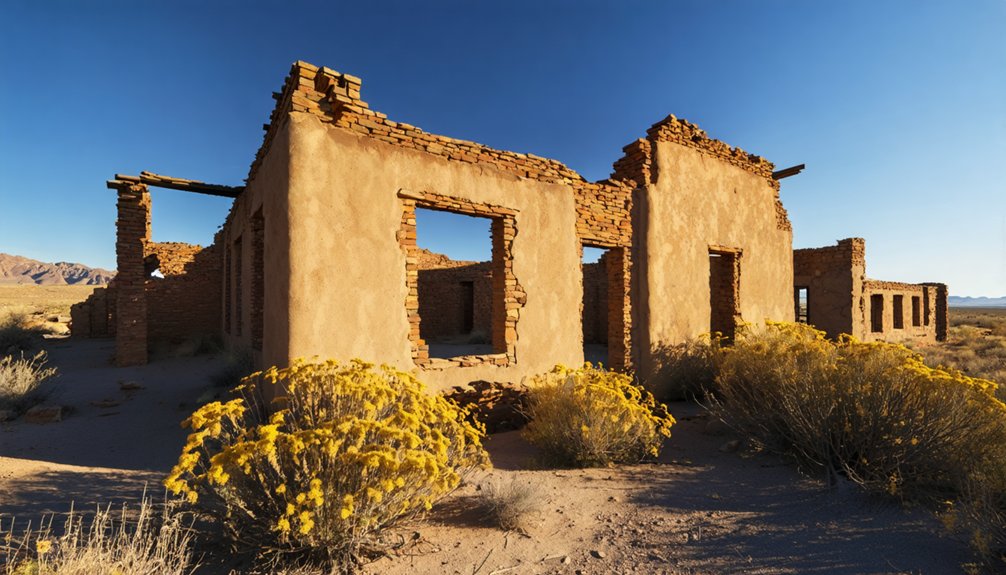
After conquering the rugged approach, you’ll discover Signal exists now as little more than whispers in stone and rust. Scattered foundations mark where miners once called home—crumbling house bases, weathered mill remnants, and skeletal mine structures dot the halfway point along your journey. These historic structures stand defiant against the desolate Artillery Mountains backdrop, their stories etched in every fractured stone.
The natural surroundings have reclaimed much of what humanity built here. No active operations remain, just echoes of frontier ambition scattered along Signal Road. You’ll find yourself walking among these remnants, imagining the bustling community that once thrived despite the isolation. The 18.7-mile point-to-point trail leads you through this abandoned landscape, following the maintained county road that once served as the town’s lifeline. It’s this raw authenticity that makes Signal compelling—untouched, unrestored, and unapologetically real. Like properties rotting on the vine, these structures have been left to face the harsh elements without intervention.
Life During Signal’s Golden Era
At its peak between 1877 and 1880, Signal buzzed with 800 residents who kept five stores, thirteen saloons, three restaurants, and a local brewery humming with activity. You’d have found adobe structures clustered around the mills, where miners and merchants carved out lives in the southern Mohave County wilderness.
But imagine the logistical nightmare—shop owners had to order freight six months in advance, their supplies crawling across remote desert routes to reach this isolated camp on the Big Sandy River. The McCracken mine discovery in 1884 brought renewed energy to the area, with mills establishing operations three years later to process the ore. Just across the territory in Maricopa County, Sheriff Carl T. Hayden made history in 1910 by conducting the first known automobile chase, signaling how the Old West was rapidly modernizing.
Peak Population and Buildings
During Signal’s golden era in the 1870s and 1880s, this remote Arizona settlement transformed into a thriving hub of 800 residents whose picks and dreams carved civilization from the desert floor. You’ll discover that roughly 200 structures once dotted this high-desert landscape at 1,340 feet elevation, providing housing accommodations for fortune-seekers who refused conventional paths.
The town’s commercial amenities reflected genuine frontier dynamism—five general stores stocked provisions, three restaurants served hearty meals, and one brewery quenched miners’ thirsts after grueling shifts.
Ore-processing mills thundered day and night, crushing silver and gold from the McCracken mines. Even after ore depletion gutted the population to 300 souls by the late 1880s, Signal persisted until 1932, when the post office finally closed and wanderers reclaimed their freedom elsewhere. While Signal faced decline, Arizona’s resident population steadily grew from 1960 onward according to US Census Bureau records. Communication between mining operations relied on electrical signals carried through telegraph wires that connected Signal to larger Arizona territories.
Remote Supply Chain Challenges
The punishing forty-mile stagecoach journey from Prescott tested every passenger’s resolve, jolting over desert trails so primitive that a single trip consumed two full days of bone-rattling misery. You’d watch mule trains creeping toward distant railheads at Mayer, knowing your dynamite shipment wouldn’t arrive for six weeks.
Freight logistical hurdles multiplied with every monsoon that washed away access routes and every Apache raid that demanded armed escorts.
Water supply vulnerabilities strangled operations worse than any mine collapse. Big Bug Creek lay twenty miles distant, forcing operators to haul 500-gallon barrels through scorching heat at $10,000 annually. Contaminated runoff poisoned shallow wells while perishable goods rotted in transit. When winter freezes blocked supply lines, scurvy claimed workers faster than rockfalls.
Signal’s isolation wasn’t romantic—it was brutally expensive.
Best Times to Visit the Desert Ruins
Your journey to Signal’s weathered ruins demands careful timing, as the Sonoran Desert’s temperamental climate can transform a memorable adventure into a grueling ordeal.
Winter and fall emerge as your golden windows, offering pleasant 50s–70s°F temperatures that let you explore crumbling mine buildings and abandoned structures without battling the region’s punishing heat.
Summer’s 93–97°F inferno restricts outdoor exploration to brief early morning windows, while monsoon rains turn the 16-mile dirt access road into an impassable quagmire of mud and flash flood danger.
Seasonal Weather Considerations
Arizona’s ghost town ruins reveal themselves differently with each passing season, transforming your exploration from serene winter wandering to challenging summer survival. You’ll find December through February offers comfortable highs between 56-68°F, though nighttime temperatures plunge below freezing—pack layers for your dawn investigations.
Spring’s March-May window brings rising heat and April’s 8 mph winds that kick up seasonal dust storms across abandoned settlements. Summer’s July peak hits 96°F with brutal 40°F daily temperature swings, while variable precipitation levels during August’s monsoon can flood desert washes without warning.
Fall’s September-November period delivers pleasant 88°F highs as moisture fades. Time your visit between winter’s mild days or fall’s post-monsoon calm—you’ll discover Signal’s secrets without battling extreme elements that’ve already claimed this town.
Avoiding Extreme Heat
Desert ghost towns demand timing as precise as the prospectors who once staked their claims here, and Signal’s crumbling structures won’t forgive poor planning when temperatures soar past 105°F. Timing visits to avoid heat means steering clear of June through August, when mercury climbs relentlessly and monsoon storms discharge flash floods across canyon floors.
You’ll find freedom in managing seasonal temperature swings by choosing October through April, when comfortable 50s to 70s allow all-day exploration without heat exhaustion threatening your adventure.
Summer’s brutal midday hours force you indoors precisely when you’d rather photograph weathered timbers and abandoned mineshafts. Instead, embrace spring’s wildflower-dotted trails or fall’s golden light casting long shadows across Signal’s ruins, where you’ll wander freely without dodging dangerous heat waves.
Essential Gear and Vehicle Requirements
Before you point your vehicle toward Signal’s weathered ruins, understand that proper preparation separates an unforgettable adventure from a dangerous ordeal in Arizona’s unforgiving backcountry. Your high-clearance 4×4 needs two spare tires, recovery straps, and traction aids—self-rescue capability isn’t optional here.
Pack 10+ gallons of water and verify your fuel planning strategies by adding 50% to GPS distances; Patagonia’s the last fuel stop before Signal’s 45-mile loop.
Satellite communication becomes your lifeline where cellular signals vanish into canyon walls. Load offline maps, first aid supplies, and emergency overnight gear.
Vehicles narrower than 60 inches navigate technical sections best, though stock rides handle maintained county roads adequately during dry conditions. Master basic towing procedures before departure—isolation demands self-sufficiency when mechanical failures strike miles from civilization.
Points of Interest Worth Exploring
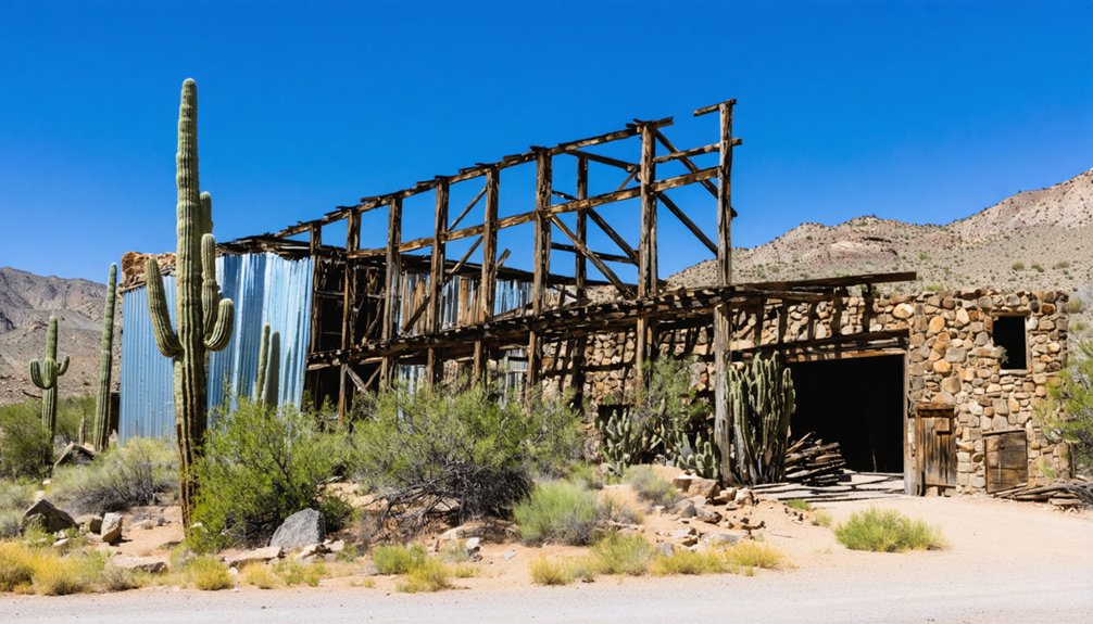
Your wheels crunch across Signal’s bleached landscape where the mill ruins command attention first—that skeletal sentinel of corrugated metal and weathered timber rising from the desert floor like a monument to ambition gone cold. Full-sized railroad tracks still crown its roof, supported by hollow I-beam ties that speak to engineering ingenuity.
Beyond lies the cemetery, where approximately 60 graves receive care from Americans MC members, preserving memory in this archaeological site. The historical significance becomes tangible as you wander fragments of what supported 800 souls—remnants of 200 buildings scattered among creosote and cactus.
Environmental preservation efforts protect these artifacts from those who’d claim souvenirs, though bullet-pocked surfaces reveal not everyone respects the silence. Wildlife watches your passage through this copper-era graveyard.
Preparing for Extreme Isolation
Signal’s remoteness demands respect—this isn’t a day trip you can wing with half a tank and optimism. You’ll be adapting to austere conditions where cell service vanishes, towns disappear, and help becomes a distant concept. Pack emergency supplies like you’re planning for isolation: extra water, food, medical kit, GPS devices, physical maps. The desert doesn’t compromise.
Coping with sensory deprivation means embracing the stark silence and endless horizons rather than fighting them. This landscape strips away distractions, leaving you alone with vast emptiness and your thoughts. Bring entertainment for downtime—books, downloaded podcasts, offline navigation. Check your vehicle thoroughly: spare tire, fluids, battery charge. Notify someone of your route and expected return. Signal rewards the prepared; it punishes carelessness without mercy.
Frequently Asked Questions
Are There Any Guided Tours Available to Signal Ghost Town?
No guided tours available exist for Signal Ghost Town—you’ll explore this remote outpost solo. For group tour options, consider Goldfield’s lantern-lit adventures or Jerome’s haunted walks instead, where professional guides reveal Arizona’s most spine-tingling mining town mysteries.
Exploring ghost towns in Arizona allows visitors to step back in time and experience the remnants of the Old West. Each site tells its own unique story of boom and bust, offering a haunting atmosphere and a glimpse into the hardships faced by early settlers. Be sure to document your journey, as these forgotten places often hold secrets waiting to be uncovered.
Exploring abandoned towns in Arizona unveils stunning landscapes and remnants of a once-thriving culture. The haunting silence is often broken only by the whispers of the past, drawing in adventurous souls eager to uncover the stories etched into the crumbling walls. Each abandoned structure serves as a canvas for both nature’s reclamation and human history, making it a compelling destination for historians and explorers alike.
Can I Camp Overnight Near the Signal Townsite?
Yes, you’ll find overnight camping options along Signal Road’s free BLM dispersed sites. Nearby campsites availability includes spots with fire rings where you can park your rig and sleep under Arizona’s star-filled skies—no reservations needed.
Is Cell Phone Service Available in the Artillery Mountains Area?
Cell phone service is extremely unreliable in the Artillery Mountains due to phone coverage limitations and remote location challenges. You’ll likely find yourself off-grid here, so plan accordingly and embrace the disconnected wilderness experience that awaits you.
Are There Any Entrance Fees or Permits Required to Visit Signal?
No fees or permits drain your wallet at Signal—it’s gloriously free, unlike those tourist-trap ghost towns. You’ll find rugged parking availability among desert scrub, though don’t expect visitor facilities. Just pure, unregulated exploration awaits your independent spirit.
What Is the Nearest Town With Gas Stations and Supplies?
Apache Junction’s your nearest hub, just miles away with In The Zone gas station offering fuel and supplies. You’ll find closest town amenities along Signal Butte Road, plus nearby lodging options for extending your ghost town adventure into something memorable.
References
- https://www.ghosttowns.com/states/az/signal.html
- https://www.youtube.com/watch?v=Jn9g0m_aJJw
- https://www.arizonahighways.com/article/arizona-ghost-towns
- https://www.apcrp.org/SIGNAL/Signal_Mast_081110.htm
- https://kids.kiddle.co/Signal
- https://www.trailsoffroad.com/US/arizona/trails/5831-signal-road
- https://www.youtube.com/shorts/VbNHsQyhgpo
- https://en.wikipedia.org/wiki/Signal
- https://www.youtube.com/watch?v=s8Yq6a0rkGc
- https://santacruzheritage.org/wp-content/uploads/2021/12/Mining-Booms-1.pdf


