
Somerfield, Pennsylvania is a ghost town that’s been hiding beneath the Youghiogheny River Lake since the 1940s, when the Army Corps of Engineers flooded the entire valley. During severe droughts, water levels drop enough to expose the 1818 Great Crossings Bridge, old street foundations, and remnants of a community that once thrived along the National Road. You can actually walk the bridge when conditions are right. Stick around and you’ll find everything you need to plan your trip.
Key Takeaways
- Somerfield, Pennsylvania, is a submerged ghost town along Youghiogheny River Lake, only accessible during severe droughts when water levels drop below 1,392 feet.
- Reach Somerfield via Old Route 40 from Uniontown, PA (20 miles southeast) or Cumberland, MD (18 miles northwest) using US-40.
- The 1818 triple-arch Great Crossings Bridge becomes walkable during significant reservoir drawdowns, offering rare direct contact with 19th-century history.
- Check water levels before visiting, as rainfall quickly diminishes exposure opportunities; download offline maps due to limited cell service in the area.
- Wear waterproof boots, bring a wide-angle camera, and never remove artifacts or drive vehicles onto the exposed lakebed.
What Is Somerfield and Why Did It End Up Underwater?
Tucked along the banks of the Youghiogheny River in southwestern Pennsylvania, Somerfield was once a thriving rural community that sat at one of early America’s most important crossroads — the point where the National Road, the country’s first federally funded interstate highway, crossed the river.
Established in 1816, Somerfield history stretches back to a time when this small valley town was the largest settlement in the region.
That all changed in the 1940s when the Army Corps of Engineers built a dam downriver, deliberately flooding the entire valley. By 1944, the town was officially abandoned, its 176 residents displaced and its structures razed.
Today, Somerfield’s submerged infrastructure — including streets, foundations, and a stunning 1818 triple-arch sandstone bridge — rests silently beneath Youghiogheny River Lake.
When Can You Actually Visit the Submerged Ghost Town?
Visiting Somerfield isn’t as simple as pulling off the highway and walking down to the water — most of the year, there’s nothing to see but a calm, deep reservoir sitting quietly over the town’s bones.
The drought impact is what changes everything. When water levels drop below 1,392 feet, history resurfaces.
Here’s when you can actually explore:
- Severe drought periods — like late October 2024, when the bridge fully emerged for the first time in years
- Reservoir drawdowns exceeding 100 feet — exposing foundations, streets, and the 1818 triple-arch bridge
- Before significant rainfall returns — your window closes fast once water rises again
Plan around dry seasons, monitor lake levels, and move quickly. The historical significance here won’t wait long.
How Do Drought Levels Control Your Visit Window?
Your visit timing hinges entirely on that threshold. Check current lake elevation data from the Army Corps of Engineers before you drive out — they track Youghiogheny River Lake levels in real time.
Once significant rains return, the window closes fast. The water doesn’t negotiate. You either catch the exposure or you’re staring at a quiet, unremarkable lake.
How to Get to Somerfield, Pennsylvania
To reach Somerfield, you’ll head to Fayette County in southwestern Pennsylvania, traveling to the Youghiogheny River Lake area off old Route 40, America’s first federally funded highway — the same National Road that once carried travelers straight through this now-submerged town.
Park near the lake’s shoreline access points, where you’ll find limited but manageable spots to leave your vehicle before heading toward the exposed bridge and foundations on foot.
No vehicles can access the submerged areas themselves, so wear sturdy shoes and come prepared to walk the same sandstone bridge that’s been sitting silently underwater since 1944.
Driving Directions To Somerfield
Getting to Somerfield, Pennsylvania is a straightforward drive once you’re on Old Route 40, the historic National Road that originally carried travelers through this very valley back in 1816.
Follow these simple directions to reach the lake’s edge and explore what remains of this extraordinary Somerfield history:
- From Uniontown, PA – Head southeast on US-40 East approximately 20 miles toward the Maryland border.
- From Cumberland, MD – Drive northwest on US-40 West roughly 18 miles into southwestern Pennsylvania.
- At the Youghiogheny River Lake overlook – Park near the shoreline access points to view submerged architecture when drought conditions permit.
You’re fundamentally retracing America’s first federally funded highway — the same road that once led directly into a town now sleeping underwater.
Parking And Entry Points
Once you’ve parked, there are two main entry points worth knowing before you make the trek down to the water’s edge.
You’ll find informal parking options along the roadside near the old Great Crossings Bridge access area — no designated lots, no entry fees, no gates telling you where you can or can’t go. Just pull off safely and walk down.
The first entry point follows a worn path directly to the bridge itself. The second traces along the shoreline, giving you a broader view of the exposed foundations and former streets.
Both routes are accessible on foot, though the terrain gets uneven closer to the waterline. Wear sturdy shoes, bring water, and move at your own pace — this place rewards the curious.
What You’ll See at the Great Crossings Bridge
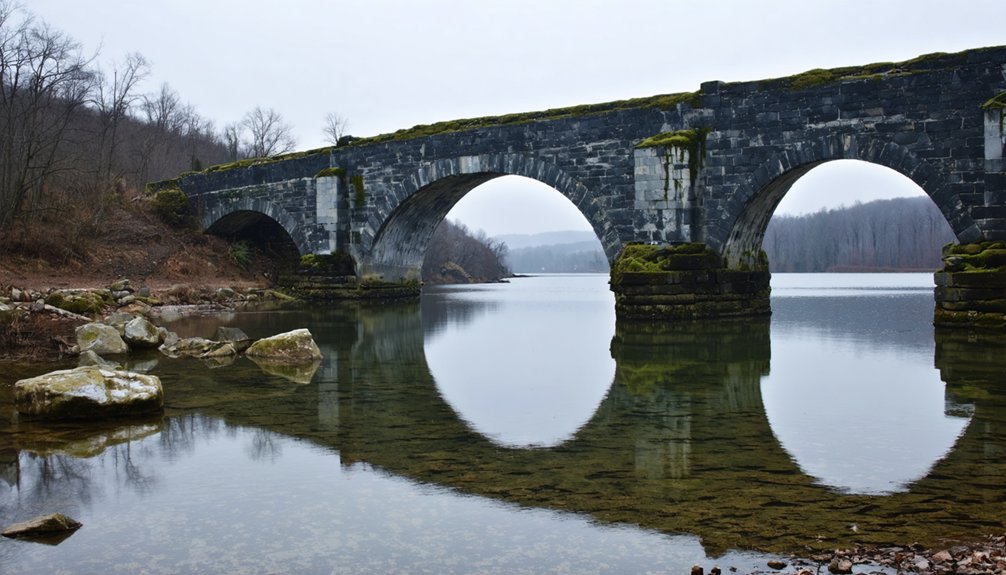
When you step onto the Great Crossings Bridge, you’re walking on the same triple-arch sandstone structure that carried travelers along America’s first federally funded highway back in 1818.
This ghost town exploration experience connects you directly to history most people never get to touch.
Look around and you’ll spot:
- Three intact sandstone arches rising from the lakebed, remarkably preserved after decades underwater
- Submerged street outlines where Bridge Street and River Road once carried daily community life
- Residential foundations scattered nearby, marking where 176 displaced residents once built their lives
The historical significance here hits differently when you realize this structure sat 50 feet underwater before drought pulled back the curtain.
History buried 50 feet underwater — until drought pulled back the curtain and revealed what time forgot.
You’re standing where history was literally buried.
Can You Walk on the Bridge and Enter the Town Foundations?
When water levels drop low enough, you can actually walk across the Great Crossings Bridge, tracing the same three-arch sandstone span that travelers crossed back in 1818.
Beyond the bridge, you’re free to wander through the exposed town foundations, where Bridge Street and River Road reappear like old bones rising from the lakebed.
That said, access is limited to foot traffic only, with no vehicles allowed, and officials can restrict entry depending on conditions or preservation concerns.
Walking The Exposed Bridge
During low-water events, you can actually walk across the Great Crossings Bridge — a triple-arch sandstone structure that’s spent most of the last 80 years sitting 50 feet underwater.
Drought impacts have gifted explorers something remarkable: direct contact with bridge history dating back to 1818.
Here’s what you’ll experience walking this exposed landmark:
- Solid sandstone underfoot — the three arches remain structurally intact despite decades of submersion
- Surrounding town foundations — Bridge Street and residential remnants emerge from the lakebed around you
- Unfiltered historical atmosphere — no barriers, no crowds, just open access to a genuinely forgotten American crossroads
You’re standing where National Road travelers once crossed the Youghiogheny River.
That freedom feels rare — because it genuinely is.
Exploring Town Foundations
Beyond the bridge itself, the exposed lakebed opens up an entire ghost town grid you can freely explore on foot.
Old street layouts, residential foundations, and scattered remnants of everyday life emerge from the mud like a preserved time capsule. Somerfield’s town history stretches back to 1816, and walking these foundations puts you directly inside that story.
You’re stepping through a community that once housed 176 residents before the Army Corps of Engineers erased it entirely. The archaeological significance here is real — these structures survived decades underwater largely undisturbed.
You can trace where homes once stood, follow former road beds, and piece together a neighborhood that most people never knew existed. Just move carefully, because the exposed lakebed surface can shift unexpectedly underfoot.
Access Rules And Restrictions
Surprisingly, you can walk directly on the Great Crossings Bridge and explore the exposed town foundations without any formal permit or restricted access during low-water events.
Follow these access guidelines to make the most of your visit:
- Arrive during documented low-water windows — drought conditions dropping below 1,392 feet elevation expose the bridge and foundations for walking.
- Respect preservation efforts — don’t remove artifacts or disturb structural remnants; these ruins represent displaced families and erased community history.
- Check water levels before driving out — significant rainfall raises the reservoir quickly, closing your access window without warning.
You’re fundamentally walking through a drowned neighborhood frozen in 1944, completely free and open beneath an open sky — until the water reclaims it again.
What to Bring When Visiting Somerfield During Drawdown
When you’re picking your way across a triple-arch sandstone bridge that’s spent decades underwater, the right gear makes a real difference.
Wear waterproof boots with solid grip — the exposed stone stays slick long after the water retreats. Bring layered clothing, since drawdown conditions mean unpredictable weather near the reservoir’s edge.
For ghost town exploration, pack a camera with a wide-angle lens to capture the bridge’s full three-arch span.
A printed map of Somerfield history helps you identify foundations and former street lines that aren’t labeled on-site. Carry water, snacks, and a dry bag for your electronics.
Cell service runs thin out here, so download offline maps beforehand.
And always check water levels before you go — conditions can shift fast.
What Are You Actually Allowed to Do at the Site?
How far can you actually push it once you’re standing on that old sandstone bridge? Honestly, ghost town exploration here comes with real boundaries worth respecting.
You’re welcome to:
- Walk the exposed bridge and photograph the triple-arch sandstone structure freely during low-water periods.
- View foundation remnants of former streets and homes from accessible shoreline areas.
- Document the archaeological significance of preserved mid-20th century displacement history through photos and observation.
What you can’t do is drive vehicles onto submerged areas or disturb any structural remnants. Official oversight exists here, and it’s not just bureaucratic noise — these ruins survived decades underwater because people left them alone.
Treat it like borrowed time, because once the rains return, everything disappears again beneath those crystal-clear depths.
Frequently Asked Questions
Was Somerfield’s Original Name Different Before the Town Was Renamed?
Somerfield once answered to a different calling — its Original Name was Smythfield. Explore the Town History, and you’ll find it shed that identity to avoid confusion with another town sharing the same name.
How Many Residents Were Displaced When Somerfield Was Abandoned in 1944?
When Somerfield was abandoned in 1944, you’d find 176 residents uprooted from their homes, leaving behind a rich town demographics and displacement history that still echoes beneath those quiet, mysterious waters today.
Is Youghiogheny River Lake Water Clean Enough to See Submerged Structures?
Clearly, crystal-clean conditions let you witness water clarity that’s truly remarkable! Youghiogheny River Lake’s oligotrophic waters stay nutrient-free, giving you stunning visibility up to 120 feet deep, so you’ll freely explore Somerfield’s submerged history below.
Are Other Submerged Pennsylvania Towns Accessible Like Somerfield During Droughts?
Most submerged Pennsylvania towns won’t reveal their forgotten histories and submerged secrets like Somerfield does. You’ll find Livermore and Wilsonville remain restricted, keeping their drowned stories locked away, making Somerfield your rarest window into reclaimed freedom.
Did the National Road Historically Pass Directly Through Somerfield’s Town Center?
The National Road’s road history took you directly through Somerfield’s heart, crossing the Youghiogheny River right there. Town evolution shaped everything around that crucial crossing, making it America’s first federally funded highway’s unforgettable junction.
References
- https://www.onlyinyourstate.com/trip-ideas/usa/432649
- https://myfamilytravels.com/the-pennsylvania-recreation-area-named-for-a-submerged-ghost-town-and-a-bridge-lost-to-the-deep/
- https://www.facebook.com/jacksontownship.historicalpreservation/posts/706056042760278/
- https://www.youtube.com/watch?v=ujCWM9PefHI
- https://www.facebook.com/groups/pennsylvaniaphotos/posts/3844260962510944/
- https://www.thecooldown.com/outdoors/somerfield-pennsylvania-historic-drought-town/
- https://www.pennlive.com/life/2016/10/13_creepiest_places_in_pennsyl.html
- https://www.observer-reporter.com/opinion/op-eds/2024/dec/04/op-ed-the-long-lost-village-that-refuses-to-die/
- http://www.kathrynbashaar.com/2021/01/the-national-road-part-one/
- https://pagenweb.org/~somerset/addison/somerfield_town.htm


