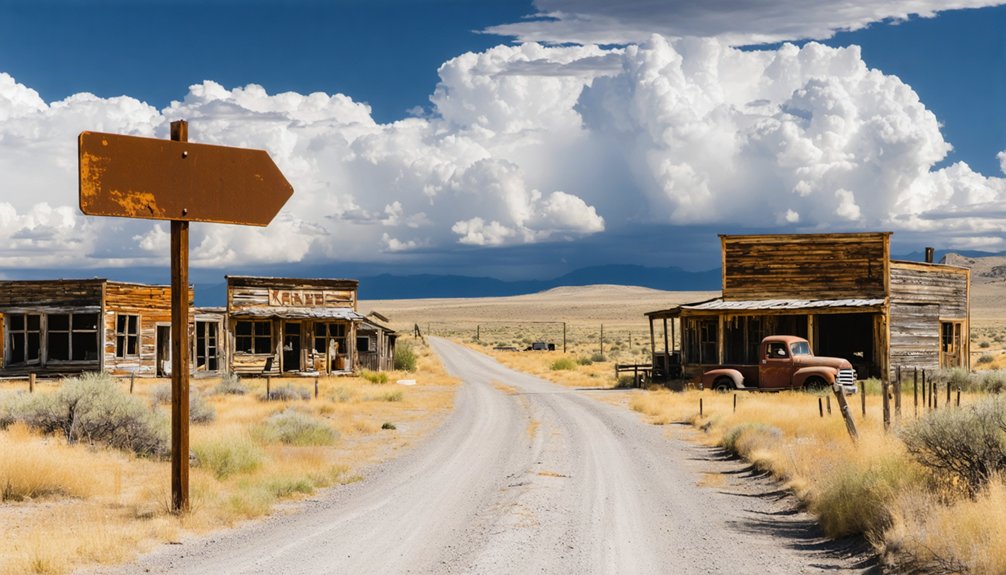
Start your journey in Jacksonville, heading south on Highway 238 before turning onto Cady Road and following Sterling Creek Road 6.3 miles into the Siskiyous. You’ll find Sterlingville Cemetery—the sole survivor of an 1850s gold rush town where 1,500 dreamers once lived. Walk among 150 weathered headstones behind an aluminum gate, then extend your adventure along the Applegate Wine Trail, Lost Creek Covered Bridge, and Sterling Mine Ditch Trail’s wildflower-lined paths to discover what else these forgotten hills hold.
Key Takeaways
- Start from Jacksonville, head south on Highway 238, turn at Cady Road, then follow Sterling Creek Road for 6.3 miles.
- Check Highway 238 traffic updates before departing, as cellular service is limited in the remote area.
- Visit Sterlingville Cemetery, the sole surviving landmark with 150 graves and an aluminum entrance gate marking the ghost town.
- Explore nearby attractions including Jacksonville’s storefronts, Applegate Wine Trail, Lost Creek Covered Bridge, and Sterling Mine Ditch Trail.
- Expect narrow, winding roads through dense forest where collapsed mining shafts and overgrown brush obscure the 1850s gold rush town.
The Rise and Fall of a Gold Mining Settlement
While most prospectors jealously guarded their discoveries, James Sterling’s secret didn’t last long. After he and Aaron Davis struck gold on a Little Applegate Creek tributary in 1854, word spread fast. Sterling’s refusal of a half-claim—when discoverers traditionally received double—signaled his determination to claim what he’d earned.
Within two years, you’d have found yourself in a boomtown of 1,500 souls. Sterlingville’s demographic diversity was evident in operations like Gin Lin’s 1864 claim, where Chinese workers transformed “played out” mines into profitable ventures. The community infrastructure exploded: boarding houses, saloons, stores, even a school district materialized from wilderness.
What Remains of Sterlingville Today
When you finally reach Sterlingville’s remote location, you’ll find nothing but dense forest reclaiming what was once a thriving 1,200-person town—the mining shafts have collapsed beneath where buildings stood, and brush tangles over every trace of commerce and community.
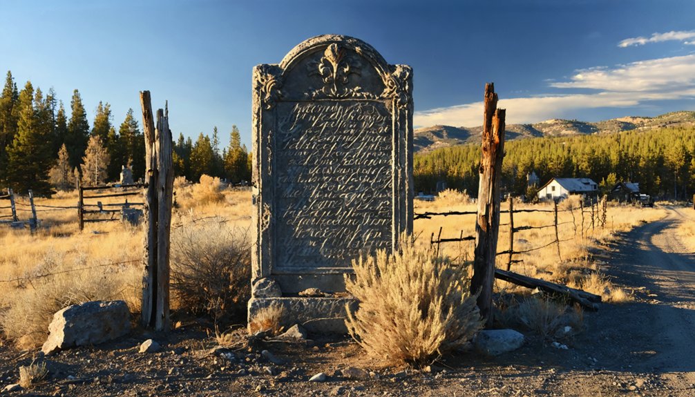
The sole landmark that survived time and wildfire is Sterlingville Cemetery, marked by an aluminum gate along a dirt road 4.2 miles from Buncom. Behind that gate, weathered gravestones dating back to 1863 stand as silent storytellers, the earliest belonging to Susan Ida Smith, while the town she knew has vanished completely into the Oregon wilderness.
Cemetery: Sole Surviving Site
Today, a lonely cemetery on a scrub-covered hillock stands as the sole surviving trace of Sterlingville’s brief but vibrant existence. You’ll find 150 documented graves here, telling stories of gold rush dreams and harsh realities. The earliest marked grave belongs to Susan Ida Smith, who died in 1863, just nine years after James Sterling’s gold strike sparked the boom.
The Sterlingville and McKee Bridge Historical Societies handle cemetery maintenance, preserving this social history significance for wanderers like you. An ornamental iron gate welcomes vehicles for an easy turnaround.
As you walk among weathered headstones—noting the Saltmarsh family’s tragic infant losses, Patrick Fehely’s final rest—you’re touching the last tangible remnant of 1,200 souls who once called this vanished town home.
Overgrown Townsite Terrain
Beyond the cemetery’s iron gate, nature has waged an absolute war of reclamation against Sterlingville’s memory. Towering eucalyptus and fir trees now dominate what was once a bustling mining community. You’ll find nothing but dense thicket overgrowth where saloons and storefronts stood—no weathered clapboards, no crumbling foundations, just unrelenting forest. Mining shafts that once promised fortune ultimately devoured the abandoned buildings from below, while farmers repurposed the watershed above.
The rugged terrain access requires traversing wooded, winding forest roads for over six miles. When you finally reach the scrub-covered hillock, you’ll understand why only 123 residents remained by 1860. Today’s rural properties occupy the former footprint, and surrounding trails offer breathtaking Siskiyou Mountains vistas—nature’s compensation for erasing history.
Historical Gravestones Tell Stories
While Sterlingville’s buildings have vanished beneath the forest floor, the cemetery preserves intimate fragments of frontier life in weathered marble and sandstone. You’ll find Susan Ida Smith’s 1863 grave marking the settlement’s earliest days, alongside heartbreaking family memorials like the Saltmarsh plot—where tiny Bert lived just two months and twenty-one days in 1859.
The Fehely and Ankeny families rest here too, their stones displaying touching symbolism of crossed palms and draped urns. Patrick Fehely and wife Sarah Jane lie together, while Mary E. Saltmarsh’s marker notes her exact age: 43 years, eight months, five days. These 150 recorded graves represent dreams chased and lives lived hard. The Rogue Valley Genealogical Society continues documenting these stories, ensuring gold rush families aren’t forgotten.
Getting to the Cemetery Site From Jacksonville
Your journey to Sterlingville Cemetery begins in historic Jacksonville, where you’ll head south toward the Applegate Valley on Highway 238.
Watch for the Cady Road intersection on your right—this marks your turn-off point where pavement gives way to the rural backroads that wind through oak-studded hillsides.
From here, Sterling Creek Road becomes your ribbon of gravel, threading 6.3 miles through the Siskiyou foothills to a forgotten boomtown where miners once struck gold.
Highway 238 Starting Point
From Jacksonville’s historic center, you’ll point your vehicle west on Highway 238, leaving behind the brick storefronts and wooden sidewalks as the road climbs toward Jacksonville Summit. This starting point marks your gateway to Sterlingville’s forgotten cemetery, roughly 2.8 miles ahead to the summit itself.
Check highway 238 traffic updates on Waze before departing—cellular service weakens considerably once you’re past the guardrails. The highway 238 distance metrics matter here: you’re looking at approximately 6 miles total once you turn onto Sterling Creek Road from the summit junction.
I’ve made this drive countless times, watching Jacksonville’s tourist bustle fade into silence. The pavement narrows, pines crowd closer, and civilization becomes memory. That’s when you know freedom’s waiting.
Cady Road Turn-Off
The summit arrives faster than expected—2.8 miles from Jacksonville’s center, Highway 238 crests at a junction marked by aging guardrails and a roadside pullout where logging trucks sometimes idle. You’ll turn left here onto Cady Road, where the pavement narrows and curving road segments wind through timber shadows. The descent feels counterintuitive—you’re heading downhill to reach the trailhead, not up. Residential properties nearby appear sporadically: a ranch-style home at 2040, another at 1625, their driveways cutting through manzanita. After half a mile, watch for your second right onto Sterling Creek Road. Miss it and you’ll dead-end at someone’s gate. From this turn, it’s four miles south before you’ll spot the gravel spur leading west toward Sterlingville’s forgotten cemetery.
Sterling Creek Road Route
Once you’ve made that second right, Sterling Creek Road unfolds as a ribbon of asphalt cutting through Douglas fir and madrone, deceptively civilized at first. The pavement lasts maybe a mile before terrain variations take over—gravel crunches under your tires, potholes demand attention.
I’ve watched road signage grow sparse out here, with only scattered mailbox numbers (9180, 5198, 9456) confirming you’re still on track. Properties hide behind timber curtains, seasonal creeks trickling through ravines.
At 6.3 miles from Cady Road, you’ll spot the cemetery on your left—look for that ornamental iron gate standing open like it’s been expecting you. A short dirt access road leads in. There’s room to turn around, which you’ll appreciate when the silence starts feeling too heavy.
Exploring the Historic Burial Grounds
Beyond the aluminum gate and down a narrow dirt path, Sterling Cemetery spreads across a small hillock where tall eucalyptus and fir trees cast dappled shadows over weathered headstones. You’ll find yourself walking among graves dating to 1863, when Susan Ida Smith became the first marked burial. The headstones tell raw stories of pioneer spirit—typhoid, diphtheria, and scarlet fever claimed entire families during the 1800s.
Children’s names cluster together like fallen dominos, marking when epidemics swept through. The Saltmarsh infants, both dying within months during 1884-1885, reflect the brutal reality of early settler lives. Park near the ornamental iron gate for easy turnaround, then explore on foot. The Sterlingville and McKee Bridge Historical Societies maintain these grounds, preserving fragments of forgotten dreams.
Reading the Stories in Stone: Notable Graves and Markers
Weathered granite markers rise from the earth like silent witnesses, each surface etched with names that once echoed through Sterlingville’s dusty streets. You’ll discover heartbreaking disease patterns as you walk among the headstones—typhoid, smallpox, and diphtheria carved into stone commemorating lives cut short during the gold rush era.
Family tragedies emerge through clustered children’s graves:
- Scarlet fever victims with death dates falling within weeks of each other
- Sibling markers standing like fallen dominoes across family plots
- Infant headstones documenting the brutal realities of frontier medicine
These monuments chart thousands of deaths throughout the 1800s. You’re free to wander this hilltop sanctuary, reading stories of entire families wiped out by disease and mining hardships—poignant reminders of the price paid for fortune.
Best Time to Visit and What to Bring
While ghost towns whisper their stories year-round, timing your visit to Sterlingville can mean the difference between an unforgettable adventure and a soggy disappointment. You’ll find ideal weather conditions during late spring through summer, when Central Oregon delivers 290+ sunny days and temperatures hovering in the comfortable 60s-80s range. I’ve learned the hard way that November through March brings snow and mud that’ll turn those access roads into slippery nightmares.
Pack smart for freedom: layer up for those 30-degree temperature swings between day and night. Your seasonal clothing recommendations should include sturdy boots, a waterproof jacket, and sunscreen for that relentless high-desert sun. Throw in water bottles, snacks, and a flashlight—you’re exploring remote territory where self-reliance isn’t optional.
Nearby Attractions and Extended Itinerary Options
Your Sterlingville exploration doesn’t have to end at the ghost town’s weathered foundations—this corner of Southern Oregon rewards curious travelers who build a multi-day adventure. Jacksonville’s preserved storefronts sit just minutes away, while wine tasting opportunities flourish along the Applegate Wine Trail through sustainable vineyards offering intimate tastings you won’t find in crowded Napa.
Essential nearby stops include:
- Lost Creek Covered Bridge for photography near Eagle Point
- Sterling Mine Ditch Trail’s 24-mile network with seasonal wildflowers carpeting spring meadows
- Butte Creek Mill’s working waterwheel and antique-filled grounds
The Applegate Valley Hub Crawl stretches across 500 square miles of farms and historic mining sites. Spring hikers discover the Rogue River Trail’s footbridges and waterfalls, while autumn brings fiery landscapes at Bayer Estates winery—each season revealing different treasures across this Gold Rush territory.
Frequently Asked Questions
Is Camping Allowed Near the Sterlingville Cemetery Site?
Camping isn’t allowed at Sterlingville Cemetery itself, but you’ll find dispersed BLM sites along nearby hiking trails. Contact the local historical society first—they’ll point you toward legal spots respecting this isolated, pine-shaded resting place.
Are There Restroom Facilities Available at or Near the Cemetery?
You’ll find nature’s silence unbroken—no portable restrooms nearby exist at this remote cemetery. The closest facilities sit at Oregonian Inn, half-mile away. Seasonal water availability doesn’t reach here; you’re truly off-grid, so plan accordingly before venturing out.
Is the Dirt Road to the Cemetery Accessible for RVS?
The short dirt road’s accessible for most RVs, with gravel road conditions decent enough for careful navigation. You’ll find parking availability near site at the gate, where there’s turnaround space, though you should scout ahead first for peace of mind.
Do I Need Permission to Visit the Sterlingville Cemetery?
You don’t need permission to visit during dawn-to-dusk hours, though local laws regarding cemetery visits may vary. However, potential safety concerns for tourists include unstable structures and rattlesnakes in Oregon’s ghost towns—stay alert and tread carefully.
Are There Any Fees Required to Enter the Cemetery Grounds?
No fees stand between you and this forgotten ground. You’ll find the gates open without grave maintenance requirements or visiting hours restrictions—just wild freedom among weathered stones where gold miners rest beneath Oregon’s untamed sky.


