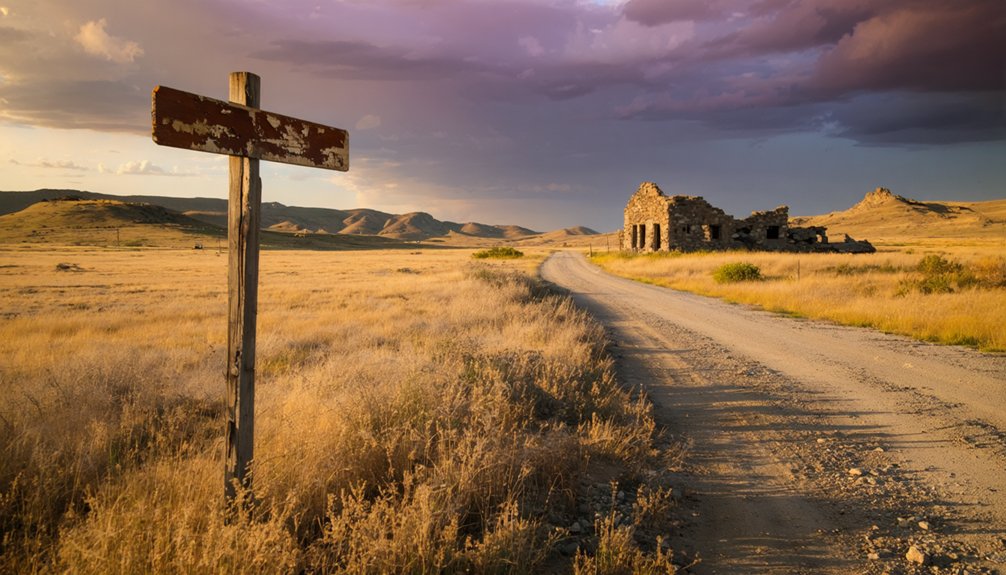
You’ll find Tigerville eight miles northwest of Hill City via Deerfield Road, where a solitary house and weathered sawmill mark what remains of a 500-person settlement that vanished within seven years. The unpaved route demands preparation for mountain conditions and summer wildfire closures, while nearby Rockerville, Mystic, and Silver City extend your Black Hills mining circuit. Pack self-recovery equipment, respirators for exploring toxin-laden ruins, and navigation backups—this remote site rewards those who understand the hazards these fortune-seekers left behind.
Key Takeaways
- Tigerville is 8 miles northwest of Hill City via Deerfield Road; unpaved terrain requires vehicles prepared for mountain conditions.
- Summer wildfire risks can close access unexpectedly; check conditions before visiting this remote, self-sufficiency-demanding location.
- Only a solitary house and old sawmill remain; most structures are crumbling foundations with no preserved cemetery.
- Nearby ghost towns include Rockerville, Mystic, Hayward, and Silver City for an extended Black Hills mining circuit exploration.
- Bring safety equipment including respirators, flashlights, first-aid supplies, navigation tools, and self-recovery gear for abandoned mine hazards.
History of Tigerville and the Black Hills Gold Rush Era
In the summer of 1874, when Lieutenant Colonel George Armstrong Custer’s expedition discovered gold in the Black Hills, they triggered a frenzy that would reshape the Dakota Territory and violate the 1868 Treaty of Fort Laramie with the Lakota Sioux. The resulting Black Hills War ended in 1877, opening these mineral-rich mountains to prospectors who’d risk everything for fortune.
Tigerville’s founding story began in 1878 near the King Solomon Mine, where gold and quartz deposits promised wealth. You’ll find this settlement embodied the classic boom-town spirit—arriving with a post office, stores, saloons, and a blacksmith shop. By 1880, 200 residents called it home, swelling to 500 at its peak. The nearby Bengal Tiger Mine sustained the town’s economic viability until 1885, when the mines closed and Tigerville’s citizens scattered like tumbleweeds.
What Remains of Tigerville Today
The years haven’t been kind to Tigerville. When you arrive, you’ll find almost nothing remains of this once-thriving community of 500.
By 1974, a solitary house and the old sawmill stood as lone witnesses to the town’s brief existence. The stores, saloons, and abandoned schoolhouse remains are long gone, reclaimed by the Black Hills wilderness. Even the Bengal Tiger Mine, which sparked such fevered dreams, left no trace.
You won’t find preserved graves and headstones marking the townsite—most evidence of daily life has vanished entirely. What you’ll discover is the profound silence of absence, the ghost of a settlement that burned bright and fast along the Cheyenne-Deadwood road, leaving barely a footprint in the soil.
Getting to Tigerville in Pennington County

Though Tigerville has faded into the Black Hills wilderness, you can still reach its ghostly coordinates at 43.9766509°N, -103.6399165°W in western Pennington County. From Hill City, navigate northwest on Deerfield Road for roughly 8 miles, where roads converge near the old town site at 5,485 feet elevation.
Ghost town accessibility depends on mountain conditions—check MapQuest for current routes before venturing out. The unpaved terrain demands preparation, especially considering summer wildfire risks that can close access unexpectedly. You’ll find Tigerville where paths from Hill City, Deerfield Lake, and Rochford intersect.
While you’re out exploring ghost towns in South Dakota, be sure to take in the stunning landscapes that surround these abandoned sites. Each town holds stories of its past, often linked to gold mining or early settler life, making them intriguing stops along your journey. Don’t forget to bring your camera, as the remnants and haunting beauty of these ghost towns provide perfect photo opportunities.
This isn’t tourist-friendly infrastructure; it’s raw exploration in the Medicine Mountain area. Bring self-sufficiency, respect the elevation’s weather shifts, and embrace the freedom of discovering a place that time deliberately forgot.
Best Ghost Towns to Combine With Your Tigerville Visit
You’ll find Rockerville just minutes from Tigerville along Highway 16, where the Gaslight Restaurant and Saloon stands as a weathered sentinel among dispersed homesteads. The route connects you to a broader Black Hills mining circuit, linking Tigerville’s abandoned lots with Rockerville’s modest revival and creating a concentrated ghost town experience.
Within an hour’s drive, you can trace the arc from complete neglect to partial survival, watching how differently these neighboring camps met their fates.
Nearby Rockerville Highway Route
After exploring Tigerville’s weathered ruins, you’ll find Highway 16 unfurls like a ribbon through the Black Hills, connecting a constellation of abandoned settlements that beckon from the ponderosa-studded slopes.
Rockerville anchors this ghost town corridor with authentic old west vibes—its pioneer relics standing defiant against time. The route rewards wanderers who chase forgotten stories:
- Rockerville: Saloon, cemetery, and original 1880s structures still breathing history
- Mystic: Shell of a mining town clinging to hillsides
- Hayward: Scattered foundations whispering of boom-and-bust dreams
- Silver City: Remote cemetery marking where prospectors once staked claims
You’ll navigate winding asphalt that miners’ wagons once struggled over, each bend revealing sun-bleached cabins and collapsing headframes. Pack water, download offline maps, and surrender to the pull of abandonment. These ghost towns demand nothing but your curiosity.
Black Hills Mining Circuit
Further north, Mystic and Rochford still cling to mountain roads where original buildings defy gravity and time.
Carbonate tells grimmer stories—James Ridpath’s 1880 silver-lead strike brought 200 miners, then diphtheria brought death.
Spokane’s mine manager house stands empty since the 1970s.
Etta near Keystone showcases massive crystal formations where lithium mining ceased in 1959.
What to Expect When Exploring the Townsite
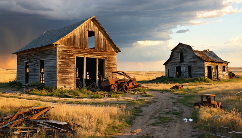
When you arrive at Tigerville’s windswept site, you’ll find little more than crumbling foundations scattered across the landscape and the ghostly outline of where a 500-person community once thrived. The remote terrain demands sturdy footwear and careful navigation around old mine shafts that still pierce the earth like open wounds from the 1880s gold fever.
Expect an atmosphere of profound emptiness—this isn’t a preserved attraction with interpretive signs, but raw remnants of boom-and-bust history gradually reclaimed by the Black Hills wilderness.
Minimal Structures and Foundations
The wind whispers through empty prairie grass where Tigerville once bustled with miners and their families, but today you’ll find little more than scattered foundations and weathered earth. Varying foundation types reveal the settlement’s history—stone cellars, wooden platforms, and concrete bases mark where homes, businesses, and community buildings once stood. Structural decay stages range from complete absence to crumbling remnants.
Your exploration will uncover:
- Building foundations scattered across the townsite with no standing structures
- Ash heaps marking former chimneys and hearths
- Railroad traces near the eastern edge where trains once connected miners to civilization
- One or two weathered structures maximum, if you’re fortunate
This barren landscape demands imagination to reconstruct Tigerville’s vanished community, offering freedom-seekers an unfiltered encounter with frontier impermanence.
Remote Location Challenges
Reaching Tigerville’s scattered foundations requires traversing unmarked trails through Black Hills backcountry where GPS signals fade and modern conveniences vanish. You’ll navigate steep, rocky terrain riddled with abandoned mine shafts and quartz-scarred hillsides—remnants of 1880s prospecting that created hazardous footing.
The harsh environment challenges include wildlife encounters with bears and rattlesnakes, unstable structures from decades of neglect, and complete absence of services since the town’s 1885 closure. Weather related accessibility issues intensify during winter snowstorms and spring rains that transform dirt roads into impassable mud. Summer thunderstorms strike with little warning across exposed ridges, while extreme temperature swings test your preparedness.
You’re truly on your own here—no cell service, no nearby fuel, no emergency help. Self-sufficiency isn’t optional; it’s survival.
Mining Era Remnants
Scattered across windswept ridges where Tigerville once thrived, the King Solomon Mine’s collapsed adits and rusted equipment mark ground zero of the 1878 gold rush that birthed this doomed settlement. You’ll discover preserved quartz outcrops glinting in sunlight—the same veins that lured hundreds westward. Abandoned mine shafts yawn dangerously throughout the terrain, their depths swallowing centuries of silence.
What remains demands your attention:
- Mine waste piles creating alien landscapes of crushed rock
- Placer mining scars reshaping creek beds and hillsides
- One surviving house standing defiant against time
- An old sawmill weathered but recognizable
The failed Bengal Tiger Mine lies miles away, its barren tunnels proving optimism couldn’t transmute stone into wealth. These remnants tell stories government textbooks won’t—of fortune-seekers who built, prospered, then vanished when profits dried.
Photography Tips and Historical Reference Points
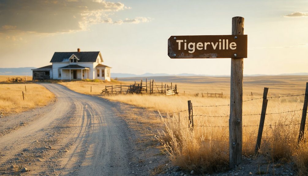
Gold rush remnants whisper their stories through weathered foundations and overgrown trails, offering photographers a canvas of desolation and historical intrigue. You’ll want wide-angle lenses to capture the sweeping Black Hills terrain where Tigerville’s single remaining house stands against sawmill foundations. Equipment considerations include macro lenses for weathered wood textures and mine waste details.
Golden hour transforms dilapidated structures into dramatic subjects, casting shadows across quartz-rich soil. Frame overgrown routes that once connected Cheyenne, Custer, and Deadwood, letting gravel paths lead viewers into your compositions. Planning logistics means researching Bengal Tiger Mine locations and cemetery placements on rocky high ground.
Shoot in 4K to preserve every crack in century-old timber, every whisper of a town that sent six representatives to rival Rapid City’s political power.
Essential Supplies and Safety Considerations for Remote Exploration
Your camera bag closes on those haunting images of Tigerville’s last standing structure, but before you navigate those remote Black Hills backroads, your survival kit demands attention. Gear redundancy isn’t paranoia—it’s liberation from dependence on rescue crews who might take hours to reach you.
Pack these essentials for true independence:
- Multiple flashlights with extra batteries for unexpected overnight stays
- Cell phone plus compass as backup navigation
- Self-recovery equipment including earth anchors for solo winching
- FFP3 respirators protecting against century-old toxins lurking in collapsed buildings
Weather contingency plans mean sturdy boots with ankle support, long sleeves guarding against sudden temperature drops, and first-aid supplies. Inform someone trustworthy about your route and return time. Freedom means preparation—you’ll explore on your terms, not emergency services’ schedules.
Frequently Asked Questions
Are There Any Camping Facilities Near Tigerville Ghost Town?
You’ll find primitive campsites nearby at Castle Peak Campground, just eight miles from Tigerville’s abandoned streets. Several local ranches offer cabin rentals available too, giving you comfortable basecamp options while exploring these hauntingly beautiful Black Hills backroads.
What Is the Best Season to Visit Tigerville?
Visit during fall when temperatures hover between 60-75°F and enjoy stunning fall foliage with fewer crowds. Alternatively, late spring offers vibrant spring wildflowers and accessible roads, though you’ll encounter occasional afternoon showers while exploring Tigerville’s ruins freely.
Do I Need Special Permits to Explore Tigerville?
You won’t need special permits to explore Tigerville’s remnants, though you should respect private property rights and follow historical preservation guidelines. The abandoned site welcomes free-spirited adventurers seeking authentic Black Hills ghost town experiences without bureaucratic restrictions.
Are There Guided Tours Available for Tigerville and Surrounding Areas?
Like pathways through forgotten time, you’ll find guided walking tours exploring Deadwood’s haunted history and self-guided audio tours near Tigerville. GeoFunTrek offers customizable ghost town adventures, letting you roam abandoned mining sites at your own pace.
What Wildlife Might I Encounter While Visiting Tigerville?
You’ll encounter abundant prairie dogs darting across open grasslands, diverse bird species soaring overhead, and possibly deer, coyotes, or pronghorns roaming freely. The untamed landscape offers authentic wildlife encounters beyond civilization’s constraints.


