You’ll find Uravan 90 miles south-southwest of Grand Junction along Highway 141, but don’t expect wooden storefronts or rusted machinery. This ghost town was entirely demolished and buried during a 20-year Superfund cleanup—every building, tree, and radioactive remnant entombed three feet underground. Two metal buildings and warning signs mark where 4,000 workers once lived. The site’s strictly off-limits, but the scenic byway offers canyon vistas, the remarkable Hanging Flume, and Driggs Mansion ruins that reveal Colorado’s mining legacy without the radiation hazards.
Key Takeaways
- Uravan is located 90 miles south-southwest of Grand Junction on Highway 141, with cell service unavailable in canyons.
- The entire town was demolished during a $120 million Superfund cleanup removing 13 million cubic yards of radioactive materials.
- Recreational access is prohibited due to lingering radiation hazards; only two county roads remain open for through-traffic.
- Nearby attractions include the Unaweep-Tabeguache Scenic Byway, Hanging Flume, and Driggs Mansion Ruins along the route.
- Download offline maps before visiting and respect warning signs protecting against radiation exposure from buried contaminated materials.
The History Behind Uravan’s Rise and Fall
Long before Uravan became synonymous with atomic power, gold prospectors picked their way through the canyons of southwestern Colorado in the late 1800s, searching for the usual glitter. Instead, they stumbled upon yellow carnotite ore—a discovery that’d reshape this remote valley.
By 1915, radium extraction processes were generating half of America’s supply at $70,000 per gram. Marie Curie used this radium in her groundbreaking radiological discoveries. When U.S. Vanadium Corporation took over in 1928, they built a company town housing 4,000 workers. Miner housing conditions improved as Uravan grew from dusty camps into a community with schools, pools, and post offices. The facility sat along the San Miguel River, surrounded by rugged canyon country 13 miles northwest of Nucla.
Then came 1942—Manhattan Project contracts transformed everything. You’d never guess this isolated outpost helped build the atomic bomb, riding uranium booms until 1984’s final closure.
Getting to Uravan: Routes and Road Conditions
The ghost town’s isolation proved both its industrial advantage and its ultimate fate—and that remoteness still defines your journey there today. You’ll follow State Highway 141 through rugged canyon country, winding 90 miles south-southwest from Grand Junction along the San Miguel River’s carved path.
From Telluride, take CO-145 North to CO-141 North—roughly an hour threading between red-rock mesas and sparse vegetation that stretches endlessly under big sky.
Check current conditions before departing; seasonal road closures can strand the unprepared in this arid landscape. Once you arrive at the 863-acre valley floor site, you’ll find limited public parking near the scattered remnants. The site is located approximately 15 miles northwest of the small town of Naturita, which serves as the nearest community for basic services.
Download offline maps beforehand—cell service disappears where canyons swallow signals, leaving only weathered benchland and the whisper of atomic-age ambitions. The ghost town sits in Montrose County, sharing its administrative boundaries with the nearby settlement of Bedrock.
What You’ll See at the Former Townsite
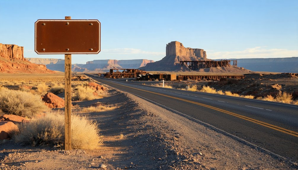
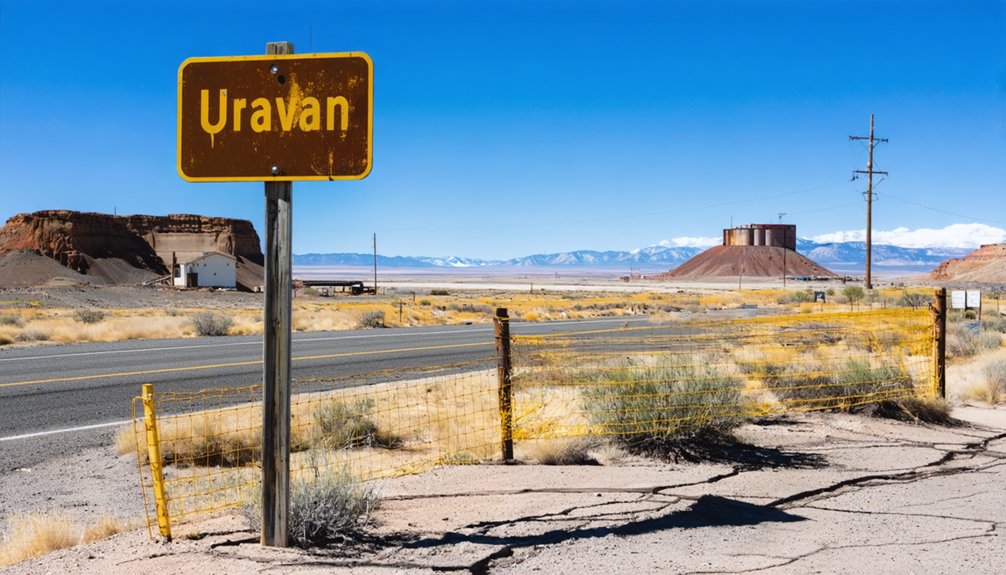
You’ll spot the weathered entrance sign from the gravel access road off County Road V 17, marking where a 700-person company town once thrived before vanishing into remediated earth.
Beyond the sign, acres of freshly bladed reddish dirt stretch across the valley floor where homes and businesses stood—now just buried foundations beneath compacted soil. Two metal buildings enclosed by tall chain-link fencing are the only vertical structures interrupting this emptied landscape, silent reminders of the industrial operations that triggered one of the West’s most extensive Superfund cleanups. The cleanup involved extracting 245 million gallons of contaminated groundwater from beneath the former townsite.
The town’s infrastructure was constructed using radioactive mine tailings, a practice that ultimately contributed to the site’s environmental contamination and eventual abandonment. Fencing and warning signage now discourage visitors from exploring the remediated landscape, keeping curious travelers at a safe distance from what remains of this atomic-age ghost town.
Historic Entrance Sign
Standing sentinel at coordinates 38°22’25.1″N 108°44’21.9″W, a lone entrance sign marks all that remains visible of Uravan, the buried mining town that once thrived in this valley. This weathered marker tells the entire story of a community erased—a portmanteau of uranium and vanadium that powered America’s Cold War arsenal before being sealed beneath tons of earth in the 1980s.
The sign design is simple but stark, positioned where the access road meets the former townsite. Its informational content warns of radiation dangers lurking beneath your feet, explaining why you can’t venture past the gate. When I visited in 2019, a tattered American flag snapped in the desert wind nearby—a haunting memorial to the families who once called this radioactive valley home. The site became a Superfund site in 1986, marking the beginning of decades of environmental remediation. Located along the Unaweep Tabeguache Scenic & Historic Byway, the marker shares its corridor with the nearby Naturita heritage site, connecting travelers to the broader story of Colorado’s mining communities.
Fenced Industrial Remnants
Approaching the sealed townsite today, you’ll encounter a stark perimeter of barbed wire fencing and bullet-riddled yellow warning signs that stretch across 680 acres of regraded earth. Beyond these barriers lies what remains after the $120 million cleanup removed buildings and buried radioactive debris beneath replanted vegetation.
What’s Still Visible from the Access Road:
- Rusted headframes marking abandoned uranium mine entrances like Van 4, frozen since 1989
- Stripped industrial remnants with exposed metal frames where salvagers pulled wiring and equipment
- Deteriorating ore hoppers standing as skeletal monuments to the extraction boom
- Warning signs peppered with bullet holes marking buried uranium mill waste locations
The fenced industrial remnants serve as your only accessible glimpse into this radioactive past, viewable strictly from designated roadways within the 25,000-acre restricted zone. These idled facilities continue to sit warehoused through regulatory loopholes that allow mine owners to avoid reclamation requirements indefinitely. The site also appears on the Colorado State Register of Historic Properties alongside several other prehistoric sites that once dotted this uranium-rich corridor near the former town.
Buried Township Foundations
Where Uravan’s downtown once bustled with 800 company workers and their families, nothing but regraded earth and native grasses now blanket the foundations. You’ll find a yellow historic sign along County Road V 17—one of the few commemorative markers acknowledging what’s buried beneath your feet. Schools, tennis courts, swimming pools, and trading posts all lie entombed under remediated soil after the $120 million Superfund cleanup.
From the gravel access road off E 22 Road, you’ll get unobstructed views across the empty townsite where radioactive mill tailings once contaminated everything from building foundations to water lines. While you can’t explore the grounds themselves—federal restrictions keep this hazardous waste site strictly off-limits—the sheer absence speaks volumes about contamination’s permanent consequences.
Understanding the Superfund Cleanup Legacy
When you arrive at the flat, eerily barren landscape where Uravan once thrived, it’s hard to imagine that an entire town—complete with homes, schools, and swimming pools—existed here until 1985. The $120 million Superfund cleanup addressed severe environmental impacts and public health concerns from decades of uranium processing:
- 13 million cubic yards of radioactive mill tailings, contaminated soil, and demolition debris were excavated and permanently buried on-site
- 380 million gallons of contaminated water were treated from groundwater seepage systems
- 50 structures were completely demolished, including every house—even trees were uprooted, shredded, and entombed
- 20 years of intensive remediation transformed the townsite into revegetated wilderness, though it remains on the National Priorities List
You’re witnessing one of America’s most extensive environmental reclamation projects.
Safety Guidelines and Site Restrictions
When you arrive at Uravan’s perimeter, you’ll encounter barbed wire fences and blunt yellow signs warning of radioactive exposure—barriers that aren’t merely suggestions but legal restrictions protecting you from contaminated soil and unstable mine shafts.
The “DANGER, NO TRESPASSING” placards at sealed mine entrances mark where radon gas still seeps from uranium-laced rock, and where crumbling sandstone could collapse without warning.
You’re standing at a Superfund site where institutional controls remain active, meaning the road stays open under DOE management, but venturing beyond designated areas puts you at risk of exposure to radionuclides, heavy metals, and physical hazards that ended remediation work on the steepest cliff faces.
Superfund Site Access Restrictions
Although the dusty roads leading to Uravan still cut through the rust-colored canyons of western Colorado, you won’t find the town that once thrived there. Since 1986, barbed wire and yellow warning signs mark this Superfund site where radioactive contamination ended a community’s story.
Current restrictions you’ll encounter:
- No trespassing permitted – fencing and institutional controls enforce permanent access limitations
- Residential structures, schools, and playgrounds banned forever from the 863-acre property
- Recreational use prohibited despite hunters and hikers occasionally risking legal consequences
- Two county roads remain open for through-traffic only
Post closure management activities continue as the site transfers to the Department of Energy. Long term environmental monitoring guarantees contaminated materials buried three feet deep stay contained, protecting those who value both wilderness and well-being.
Health Hazards and Precautions
Beyond the barbed wire at Uravan, invisible threats linger in forms far more dangerous than rattlesnakes or flash floods. The caution signs aren’t mere suggestions—radiation levels remain hazardous where the town once stood. You’ll want to keep your distance from the buried contamination, respecting boundaries that protect you from yellowcake uranium‘s persistent legacy.
If you’ve spent time near historical mining sites, consider preventative screening efforts through your physician. Long term radiation exposure monitoring proved essential for surviving miners like Bill Chadd, who still battles lung disease decades later. While environmental radiation beyond the site shows no increased cancer risk, the demolished town beneath your feet serves as a stark reminder: some ghosts are radioactive, outlasting generations in geologic time.
Nearby Attractions Along the Scenic Byway
The Unaweep-Tabeguache Scenic Byway stretches 133 miles from Whitewater to Placerville, threading through some of Colorado’s most dramatic and underappreciated landscapes. You’ll discover freedom on every curve of Highway 141, where red sandstone formations rise like ancient cathedrals and the Dolores River cuts through sheer canyon walls.
Where red rock cathedrals meet rushing waters, 133 miles of Colorado’s wildest terrain awaits your discovery on winding Highway 141.
Must-See Stops Along Your Route:
- Hanging Flume – This National Register marvel clings impossibly to canyon walls, a testimony to frontier ingenuity that once carried water to gold mines.
- Driggs Mansion Ruins – Stone remnants at mile marker 129 whisper stories of boom-and-bust ambitions.
- Scenic Overlooks – Multiple pull-offs reveal panoramic vistas across the Uncompahgre Plateau’s striated cliffs.
- Picnicking Areas – Roadside spots offer front-row seats to geological layers spanning back to Precambrian times.
Frequently Asked Questions
Are There Any Guided Tours Available of the Uravan Site?
No guided tours are offered at Uravan due to federal restrictions on the contaminated Superfund site. You’ll find local tourism information directing you to nearby scenic overlooks and alternative Colorado ghost towns where you can explore freely instead.
The ghost towns of Colorado hold fascinating stories of the past, waiting to be uncovered by adventurous travelers. Exploring these remnants of history can offer a glimpse into the lives of those who once called these places home. Make sure to visit notable locations like Central City and Cripple Creek, where well-preserved structures invite you to imagine their rich heritage.
What Health Precautions Should Visitors Take When Visiting the Area?
Wear protective gear like masks and sturdy boots when exploring. Avoid soil disturbance—don’t kick up dust from remediated areas. Stay on cleared paths, skip untreated water sources, and limit time near former tailings sites where contaminants once concentrated.
Can I Bring My Dog or Pets to the Uravan Site?
Your four-legged companion can venture through this atomic ghost town, though pet friendly regulations remain unofficial. You’ll face potential animal hazards from residual contamination, so keep dogs leashed and prevent digging in soil near former processing areas.
Where Are the Nearest Accommodations for Overnight Stays Near Uravan?
You’ll find the nearest camping options right at Uravan’s historic site with RV and tent spots. For comfortable lodging, local bed and breakfast inns like Vestal House in Nucla sit just twelve miles away, offering freedom-seekers rustic charm.
Is Drone Photography Permitted Over the Superfund Site?
Drone flight restrictions don’t explicitly ban flights over Uravan’s Superfund site, but you’ll need FAA compliance and should respect environmental contamination concerns. The decommissioned uranium site isn’t protected like state parks, offering you aerial photography opportunities within federal guidelines.
References
- https://www.youtube.com/watch?v=HDGnWZh2Db0
- https://www.atlasobscura.com/places/uravan
- https://www.hcn.org/issues/41-2/dust-to-dust/
- https://www.cpr.org/2023/12/04/what-happened-to-the-town-of-uravan-colorado/
- https://www.pecva.org/work/energy-work/uranium/tales-from-out-west/after-a-town-is-buried-controversy-still-rages/
- https://choosewestend.org/about-the-west-end/ghost-town-of-uravan/
- https://cdphe.colorado.gov/hm/uravan-uranium-project
- https://rimrockertrail.org/uravan-colorado/
- https://en.wikipedia.org/wiki/Uravan
- https://en.wikipedia.org/wiki/Timeline_of_mining_in_Colorado


