Your West Baker ghost town adventure starts in Barstow, then heads northeast on I-15 to Baker—your last fuel stop before exploring abandoned talc mine ruins. Stock up at Alien Fresh Jerky and fill your tank beneath the 134-foot thermometer before heading to West Baker’s concrete foundations and cinder block vault. You’ll find crumbling bunkhouses, spring house remains, and haunting traces of forty miners’ lives abandoned in 1978. Nearby Kelso, Calico, and Ballarat extend your desert exploration with silver rush remnants and railroad history waiting just beyond Baker Boulevard.
Key Takeaways
- West Baker talc mining camp features concrete foundations, bunkhouses, and a spring house, abandoned in 1978 near Baker Boulevard.
- Stock up on fuel, water, and supplies at Baker’s gas stations and Alien Fresh Jerky before heading into the desert.
- High-clearance vehicles are essential for navigating dirt roads leading to remote ghost town ruins in the Mojave Desert.
- Obtain permits for overnight backcountry stays in Death Valley and California Campfire Permits for any open flames.
- Avoid entering abandoned structures due to toxic hazards like arsenic, lead, and unstable buildings at mining sites.
Understanding Baker’s Role as Gateway to Death Valley
Since 1908, Baker has stood as a solitary outpost where the Mojave Desert’s scorched landscape meets the gateway to one of Earth’s most unforgiving environments. You’ll find this former railroad station positioned 60 miles from Death Valley’s southern entrance, where temperatures surge past 120°F in summer months.
The town earned its “Gateway to Death Valley” nickname through genuine hardship—December 1849 saw over 100 gold-seeking emigrants suffer brutal thirst and starvation passing through this natural corridor. Today, Baker’s historical tourism draws adventurers seeking authentic desert experience, while its geological significance connects you to Death Valley’s record-breaking 134°F heat.
Stop here for fuel, supplies, and respite before venturing into extreme terrain that’s tested travelers for over 170 years.
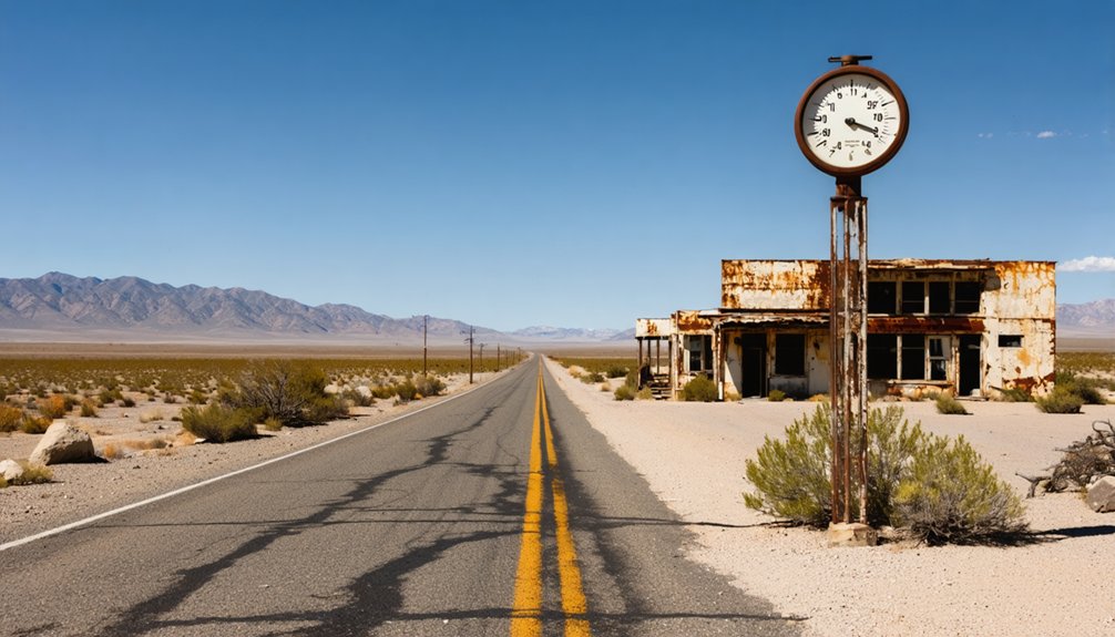
The World’s Tallest Thermometer and Baker Boulevard Landmarks
A 134-foot steel giant pierces the desert sky at 72155 Baker Boulevard, its needle-thin profile visible for miles across the flat Mojave expanse. Will Herron’s 1991 creation—built with 33 tons of steel—commemorates the region’s brutal heat while breaking the monotony of your I-15 journey. The thermometer’s visual impact draws you off the highway, where Baker Boulevard’s quirky attractions await your discovery.
Beyond this towering beacon, you’ll find Bun Boy Restaurant just 0.1 miles east of CA Highway 127, while Mad Greek Cafe and Alien Fresh Jerky compete for your attention. That jerky shop deserves your final stop—alien jerky flavors like whiskey and honey teriyaki fuel desert adventures, and those UFO decorations deliver Instagram-worthy moments. These roadside landmarks transform Baker into more than a gas stop.
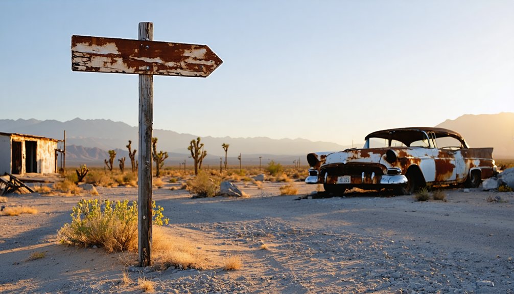
Exploring the West Baker Talc Mining Camp Ruins
Twenty miles north of Baker’s neon-lit tourist traps, the West Baker talc mining camp sprawls across sun-bleached desert hardpan like scattered bones of industrial ambition. You’ll find concrete foundations marking where boarding houses once sheltered forty miners during peak operations under Borax Consolidated, Ltd. ownership.
The site’s unique architectural features include a cinder block vault—originally holding company script currency—standing defiant among collapsed lumber and twisted metal. Concrete slabs trace the kitchen and bunkhouse footprints, while a spring house foundation reveals the ingenious water system that sustained this remote outpost.
Though abandoned in 1978, the stories behind current owners—the Mojave River Valley Museum—now preserve these weathered remnants of California’s quarter-million-ton talc empire that once supplied America’s wartime industrial needs.
Nearby Ghost Towns Worth Adding to Your Itinerary
Venture beyond West Baker’s talc ruins and you’ll discover a constellation of Mojave Desert ghost towns, each preserving distinct chapters of California’s mining legacy.
Head south to Kelso’s restored railroad depot, then explore Calico’s 500-mine silver rush remnants—complete with geological surveys documenting $20 million in ore extraction.
Cultural preservation efforts shine at Silver City near Lake Isabella, where 20 relocated structures showcase Kern Valley’s mining heritage, including the jail that held gunslinger Newt Walker.
For true solitude, navigate Echo Canyon Road to Ballarat’s remote ruins, where canyon walls frame decaying bunkhouses and mine adits.
Garlock’s barren foundations await near Highway 178, offering stark beauty without crowds.
You’ll find each site accessible via interconnected desert routes.
Recommended Driving Route From Los Angeles
Your journey from Los Angeles to West Baker’s abandoned talc mines begins along Interstate 15, where urban sprawl gives way to creosote-studded desert within the first hour. The direct route stretches approximately 175 miles, consuming just under three hours of windshield time through Victorville and Barstow before reaching Baker. You’ll want to fuel up in Barstow—the last reliable services before isolation sets in.
Alternative route options exist through Las Vegas if you’re combining adventures, though this adds considerable distance. For those seeking scenic highway detours, Highway 127 branches north from Baker itself, threading through Death Valley’s eastern edge. Stock your vehicle with extra water, verify your spare tire’s condition, and download offline maps. Cell service becomes sporadic beyond Barstow, making preparedness essential for desert exploration.
Essential Supplies and Refueling Stops
Before leaving pavement behind, Baker’s gas stations demand your attention as the last guaranteed fuel source before deep desert wandering. Stock up at Alien Fresh Jerky on Baker Boulevard before settlements stretch beyond 25-mile intervals.
Your vehicle needs high-clearance capability for dirt roads leading to abandoned talc mines and mountain camps—pack spare belts, coolant, and tire repair kits for road maintenance emergencies.
Water storage becomes non-negotiable in this unforgiving terrain. Carry one gallon per person minimum for day trips, though multi-day expeditions to Upper Noonday Camp require substantially more.
Kelso Depot’s bookstore stocks emergency water before you tackle Kelbaker Road. Desert Market in Daggett offers final provisions—grab electrolytes, non-perishables, and emergency supplies. Out here, self-reliance isn’t philosophy; it’s survival.
Access Permissions and Safety Considerations for Mining Sites
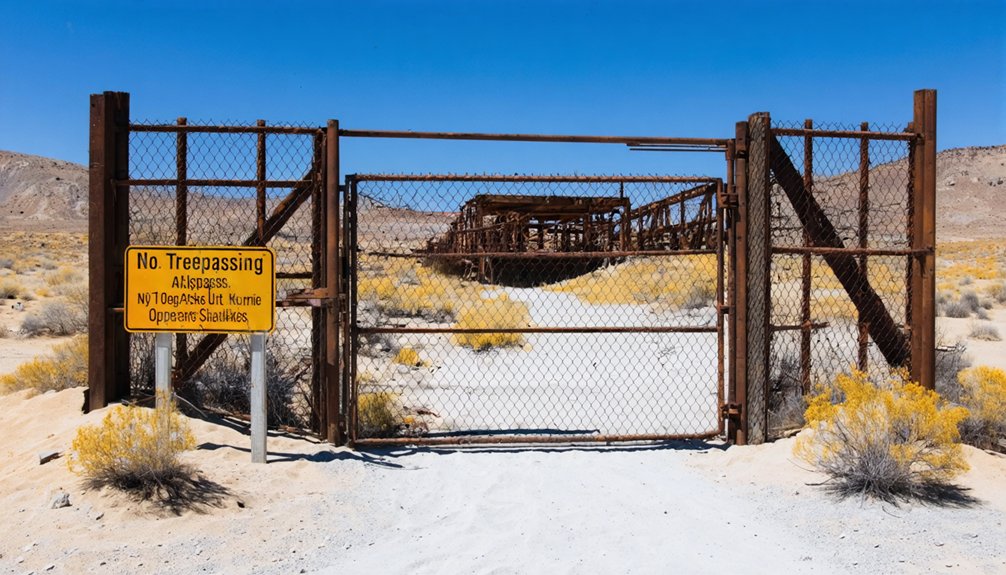
Before you venture near West Baker’s abandoned mining sites, understand that many structures stand on private land where trespassing carries legal consequences—some properties grant access only through organized group tours once a year.
The mine shafts and tunnels pose extreme dangers from unstable ground, toxic air pockets, and collapsing timbers that have claimed lives over decades of decay. You’ll need to secure proper permits for designated sites and notify local authorities of your plans, as rescue operations in remote desert terrain can take hours to reach you.
Private Property Legal Boundaries
When you’re drawn to explore California’s abandoned mining towns, understanding property boundaries becomes as essential as checking your gas gauge. You’ll encounter stark differences between open sites and secured-down properties requiring owner permission requirements. Darwin’s residents remain skeptical of wanderers, while preservation groups provide access to certain ghost towns just once yearly.
Even accessing Repressa’s old dam demands clearance from the Folsom State Prison warden—restricted access procedures that keep spontaneous exploration in check.
Watch for no trespassing signs at every turn. What’s accessible today might be fenced off tomorrow, especially when vandalism threatens these fragile sites. Desert Center’s $22.58 million ghost town sale proves private ownership rules this landscape.
Your best approach? Follow property owners on Instagram for real-time access updates, and always respect boundaries—your freedom to explore depends entirely on it.
Hazardous Mining Structure Risks
Those crumbling mine shafts and rusted headframes dotting West Baker’s landscape aren’t just photo opportunities—they’re century-old death traps waiting to claim the careless. The Iron Mountain Mine’s underground workings suffer from structural collapse risks after a hundred years without maintenance, while unsupported drifts like Dead Man’s Drift could cave in without warning.
Surface hazards multiply with unstable waste-rock dumps perched at unnatural angles and drilled boulders that shift unpredictably.
Beyond the falling-rock dangers, you’re facing toxic exposure hazards from arsenic, lead, and asbestos-laden dust kicked up by every footstep. Those historic mining roads you’re driving? They’re distributing contaminants with each pass. Calico Ghost Town’s nearby mines are so hazardous that authorities have prohibited all access—consider that your baseline for respecting West Baker’s equally treacherous structures.
Required Permits and Notifications
Nobody’s stopping you from wandering onto most ghost town sites in the Mojave Desert, but West Baker’s proximity to Death Valley National Park and surrounding BLM lands means you’ll need paperwork before venturing into certain territories.
If you’re planning overnight stays near ghost town sites within Death Valley’s backcountry, grab a voluntary permit from Furnace Creek or Stovepipe Wells—it’s free and keeps rangers informed of your whereabouts. Commercial filming or organized group explorations require Special Recreation Permits through BLM Barstow Field Office at 760-252-6000.
One intriguing site to explore is the history of mentryville ghost town, which offers a glimpse into California’s oil boom era. Visitors can wander through the remnants of the town and discover its fascinating stories of both prosperity and abandonment. Be sure to take appropriate safety precautions, as some areas may be less stable than others.
While seasonal day use regulations don’t typically apply to desert ghost towns, you’ll absolutely need a California Campfire Permit for any open flames. These backcountry permit requirements aren’t bureaucratic roadblocks—they’re your safety net when cell service vanishes and abandoned mine shafts lurk underfoot.
Frequently Asked Questions
What Is the Best Time of Year to Visit Baker and Nearby Ghost Towns?
Visit during spring or fall when comfortable weather conditions transform your desert adventure—mild 70-80°F days let you explore freely without summer’s scorching heat or peak visitation seasons’ crowds cramping your independent ghost town discoveries.
Are There Guided Tours Available for the West Baker Talc Mining Camp?
Looking for organized expeditions through mining ruins? Guided tours aren’t available for West Baker’s talc camp—you’ll explore independently. Check private property concerns before venturing onto foundations and equipment pads. Your self-directed adventure awaits across these desert remnants.
Can You Camp Overnight Near the Ghost Town Sites Around Baker?
You’ll find excellent availability of camping facilities at nearby Calico Ghost Town, offering 265 sites with full amenities just 50 miles away. Follow standard safety precautions for camping in desert conditions, and you’re set for adventure.
What Cell Phone Coverage Can I Expect in the Baker Area?
You’ll find spotty signal in this remote desert territory. AT&T offers the strongest lifeline at 71.3% coverage, followed by Verizon at 62.7%. Expect limited cellular connectivity and unpredictable service quality—download maps beforehand for true off-grid freedom.
Are the Abandoned Buildings in Baker Safe to Photograph up Close?
You can photograph Baker’s abandoned buildings from outside, but don’t enter due to structural integrity concerns and potential hazards like weak floors, broken glass, and protruding nails. Keep your distance—trespassing risks arrest, and decay makes close approach dangerous.


