You’ll find White Oak Springs near Mount Sterling in Brown County at coordinates 39.9736593°N, 90.8548538°W, though reaching this elusive ghost town requires USGS topographical maps since county roads lack conventional signage. Launch your expedition from Griggsville, 13 miles south, and fuel up beforehand—no services exist at the site. What remains today is mostly agricultural land at 680 feet elevation, with virtually no visible traces of the settlement that Arthur Martin established in 1838. The journey’s real rewards lie in understanding what drew pioneers here and why they ultimately vanished.
Key Takeaways
- Start from Griggsville, 13 miles south, and use USGS topographical maps since county roads lack conventional signage.
- Site coordinates are approximately 39.9736593°N, 90.8548538°W near Mount Sterling in Brown County’s Buckhorn Township.
- Fuel up beforehand as no services exist at the location; any vehicle can navigate the minimal terrain.
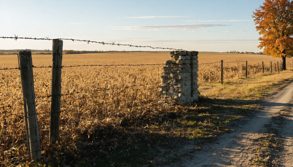
- No structures, markers, or photographic evidence remain; the settlement has returned entirely to agricultural use.
- Plan exploration before dusk considering Central Time Zone daylight; combine with nearby Galena attractions to the west.
Historical Background of White Oak Springs Settlement

When John McGee first surveyed his newly purchased hilltop land along 825 East Road in 1836, he couldn’t have known the settlement that would spring up around him would vanish within generations. You’ll find White Oak Springs‘ roots traced back to 1829, when pioneers first carved homesteads from White Oak Grove’s timber. The founding individuals shaped this Buckhorn Township community through sheer determination—Arthur Martin established the settlement’s backbone by 1838, running the post office, blacksmith shop, general store, and copper works from his property.
Early community growth followed ancient Indian trails connecting the Wabash River to Fort Clark. These well-worn paths, still visible when settlers arrived, brought travelers through on their journey westward. The village thrived briefly before railroads chose different routes, sealing White Oak Springs’ fate as another forgotten Illinois outpost.
Getting to White Oak Springs: Routes and Coordinates
You’ll find White Oak Springs near Mount Sterling in Brown County at approximately 39.9736593°N, 90.8548538°W, sitting 680 feet above sea level in Illinois’s quiet agricultural heartland. The ghost town’s remnants lie close enough to Fargo that you can use either community as your navigational anchor when programming your GPS.
I’ve learned that reaching this vanished settlement requires careful attention to county roads branching off state routes—modern mapping tools show the coordinates, but they won’t reveal which overgrown lanes once carried travelers to White Oak Springs’ doorsteps.
Exact GPS Coordinates
Finding White Oak Springs on a modern map proves nearly impossible—this forgotten settlement exists in that peculiar limbo between documented history and complete erasure. Your best starting point? Griggsville in Brown County, with White Oak Springs located roughly 13 miles north. No precise GPS coordinates exist in modern databases—you’ll navigate by instinct and local landmarks rather than satellite guidance.
Don’t expect amenities availability here; this isn’t a maintained historic site. You’re exploring genuinely abandoned territory where services don’t exist. Parking considerations become irrelevant when roads barely qualify as paths. Bring detailed topographic maps, download offline navigation, and talk with Griggsville locals who might remember the old trails. This journey demands self-reliance—you’re chasing ghosts through Illinois countryside that’s reclaimed what civilization briefly touched.
Nearby Towns and Landmarks
The ghost town sits in Brown County’s rural patchwork, with Griggsville serving as your launching point thirteen miles south. You’ll find Benville southwest and Morrelville south-southeast—blink-and-miss hamlets that frame your approach through cornfield corridors. The settlement itself dissolves into Buckhorn Township’s boundaries now.
Push west after your exploration and you’ll hit Galena’s distinct architecture—Grant’s preserved home and limestone storefronts that actually survived. Apple River Canyon State Park carves limestone bluffs worth scrambling, while Gravity Hill provides that roadside weirdness every good wanderer craves.
Head east and Oak Park’s Frank Lloyd Wright legacy awaits—his home studio and Unity Temple showcase Prairie School genius. These natural landmarks and architectural gems bookend your ghost town hunt, proving abandonment and preservation coexist across Illinois’s back roads.
Road Conditions and Accessibility
How do gravel-and-asphalt county roads deliver you to a place that’s barely a pinpoint on modern GPS? You’ll navigate Brown County’s rural network where roadway accessibility demands self-reliance and old-school map reading. Mount Sterling, your gateway at 725 feet elevation, sits just miles from White Oak Springs’ 680-foot ghost town coordinates.
Essential route considerations:
- County roads lack conventional signage—USGS topographical maps prove invaluable
- Minimal topographical changes make the terrain forgiving for any vehicle
- No services exist at the site; fuel up beforehand
The post office closed in 1848, taking infrastructure with it. You’ll find yourself on unmarked tracks where coordinates 39.9872707°N, -90.763463°W matter more than street names. Central Time Zone timing affects daylight—plan accordingly for exploration before dusk swallows these forgotten coordinates.
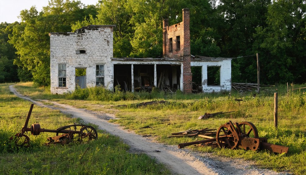
What Remains at the Ghost Town Site Today
Visiting White Oak Springs today means confronting an almost complete absence. You won’t find Arthur Martin’s blacksmith shop or general store standing—time has reclaimed nearly everything. The settlement that thrived from 1838 has vanished into farmland, leaving you to explore what’s fundamentally open countryside. There’s no photographic evidence to guide your search, no markers to confirm you’ve reached the right spot.
This disappearance reflects a common pattern among Brown County’s forgotten communities. The modern community impact is negligible; locals rarely mention the name. You’ll need imagination to picture Martin’s copper shop or the post office that once anchored this rural outpost. What remains is the landscape itself—rolling Illinois terrain that once supported a hopeful settlement, now returned to agricultural use.
Arthur Martin’s Legacy: Blacksmith Shop and General Store
At the heart of White Oak Springs‘ brief existence stood Arthur Martin—blacksmith, merchant, and postmaster rolled into one. This self-made pioneer built an empire from iron and enterprise when he established the post office in 1838. You’ll find his legacy in the entrepreneurial spirit that defined these vanished settlements.
Martin’s diversified operation included:
- Blacksmith shop producing tools and implements for surrounding farmers
- Copper shop operations crafting and repairing essential metalwork items
- General store management supplying daily necessities to Buckhorn Township residents
He understood what frontiersmen needed: practical goods, reliable repairs, and connection to the outside world. His businesses weren’t just commerce—they were lifelines. While precious little documentation survives, Martin’s multi-trade approach exemplifies the independence and resourcefulness that carved civilization from Illinois wilderness.
Why White Oak Springs Became Abandoned
You’ll find that White Oak Springs never stood a chance once the railroads carved their routes through other parts of Brown County, leaving this hilltop settlement stranded without the lifeblood of commerce and connection.
The handful of businesses—Arthur Martin’s blacksmith shop, the general store, the copper shop—couldn’t sustain themselves when farmers and travelers had easier access to larger towns along the rail lines.
Limited Economic Sustainability Factors
While the exact details of White Oak Springs’ decline remain obscured by time, the settlement likely faced the same economic pressures that doomed countless Illinois prairie villages in the mid-to-late 1800s.
You’ll find these sustainability factors probably sealed White Oak Springs’ fate:
- Farmland depletion stripped the soil of nutrients without modern agricultural knowledge to restore it
- Railroad bypass left the settlement isolated while neighboring towns prospered with direct shipping access
- Single-industry dependence made the community vulnerable when agricultural markets shifted
The demographic decline followed predictably—families packed wagons and headed west toward better opportunities. By the time you visit today, you’re standing where determined pioneers once built their dreams, only to watch economic reality force impossible choices between survival and staying put.
Transportation Infrastructure Bypassed Settlement
The killing blow came not from depleted soil or failed crops, but from the iron rails and stone-paved roads that carved paths around White Oak Springs rather than through it. When the B&O Railroad prioritized its Ohio River corridor in 1852, your settlement watched prosperity roll past on distant tracks.
The Illinois & Michigan Canal transformed Chicago into a bustling hub while leaving inland communities stranded. Restrictive transportation policies favored major gateways—the National Road, Green Bay Road, Louisville-to-St. Louis stage lines—all bypassed your springs.
Resource Depletion Effects
Beneath your feet, White Oak Springs’ farmland told a story of exhaustion written in cracked earth and stubborn clay. You’d have witnessed deforestation impacts strip the land’s namesake white oaks—once Illinois’s most abundant trees—replaced by lower-quality maples through careless high-grading.
The soil conservation challenges mounted relentlessly:
- Continuous grazing depleted sensitive herbaceous species, impoverishing woodland biodiversity
- Row crop agriculture transformed prairie savannas, accelerating erosion and sediment loss
- Stream channelization projects flushed topsoil downstream faster than nature could replenish it
Other Ghost Towns to Visit in Brown County
Beyond White Oak Springs, Brown County’s ghost town landscape offers limited but intriguing options for dedicated explorers. Milton stands as your primary alternative—a vanished settlement where farming community loss left barely a trace. You’ll find no preserved structures here, just the quiet echo of railroad bypasses that sealed its fate in the late 1800s.
These regional abandonment patterns tell a familiar story: thriving agricultural hubs becoming empty fields when economic tides shifted.
Milton’s exact coordinates remain elusive, so you’ll need county maps and perhaps a conversation with the Brown County Historical Society to pinpoint what’s left.
Expect foundations, maybe a marker if you’re lucky. Most sites sit on private land, so respect boundaries and view from public roads. It’s raw, unrestricted exploration—perfect for those craving unfiltered history.
Best Time to Explore and What to Bring

Timing your visit to White Oak Springs can make the difference between a forgettable detour and an unforgettable journey into Illinois’s forgotten past. Spring mornings bring soft light across wildflower-dotted landscapes, while fall transforms the ruins with vibrant foliage—both seasons offer comfortable weather patterns without extreme temperatures.
Pack wisely for your independent exploration:
- Sturdy, closed-toe shoes for traversing uneven terrain around weathered structures
- Plenty of water since services are nonexistent on-site
- Camera and daylight hours to capture cultural artifacts and crumbling architecture
Avoid after-dark visits for safety reasons. March through June showcases blooming scenery, while autumn delivers harvest-season atmosphere and scenic drives. Year-round access exists, but spring and fall provide ideal conditions for photographing preserved ruins and walking designated paths freely through this haunting remnant of frontier history.
Frequently Asked Questions
Are There Camping Facilities Near White Oak Springs Ghost Town?
You’ll find White Oak Campground’s availability limited but authentic, with nearby lodging options including 90 sites at Ramsey Lake. These rustic campgrounds let you embrace solitude under star-filled skies, where freedom-seekers discover Illinois’s forgotten landscapes beyond civilization’s reach.
Is Permission Required to Visit the White Oak Springs Site?
You’d think visiting a ghost town requires traversing endless bureaucracy, but White Oak Springs doesn’t demand permission slips. Just respect private property concerns and historical preservation policies—then roam freely through Illinois’s abandoned past during daylight hours.
What Safety Precautions Should Visitors Take When Exploring the Area?
Bring proper footwear for uneven terrain and crumbling foundations you’ll encounter. Avoid trespassing on private property—respect boundary markers. Watch for unstable structures, open mine shafts, and hazardous debris. Limited cell service means you’re on your own out there.
Are Guided Ghost Town Tours Available in Brown County?
No guided tours operate in Brown County, so you’ll explore White Oak Springs independently. While local restoration efforts haven’t materialized here, you’re free to discover the ghost town history on your own terms—adventure awaits without restrictions.
Can Metal Detecting Be Done at White Oak Springs?
You’ll need landowner permission before detecting at White Oak Springs—preserved artifacts lie waiting beneath the soil, but legal restrictions protect historical sites. Freedom seekers must respect property rights and Illinois archaeological laws before unearthing the settlement’s metal treasures.