
Travel about four miles north from Muskogee along unmarked county roads to find Wybark’s scattered concrete foundations emerging through tall grass like forgotten monuments. You’ll discover a weather-beaten cemetery with leaning gravestones that whisper stories of this once-thriving all-Black settlement founded in 1890. Plan your visit during spring’s comfortable 60-75°F temperatures when wildflowers frame the crumbling remnants, and you’ll want to explore nearby ghost towns like Warner and Yahola to complete your southeastern Oklahoma adventure.
Key Takeaways
- Wybark is located approximately 4 miles north of Muskogee, accessible via county roads with minimal signage and unreliable GPS coordinates.
- Visit during spring (60-75°F with wildflowers) or fall (vibrant foliage) to avoid summer heat, thunderstorms, and winter ice.
- Expect scattered concrete foundations, crumbling structures, and a weather-beaten cemetery with leaning gravestones marking the all-Black town’s history.
- Research current road conditions, property boundaries, tornado season timing, and hunting restrictions before departure for safety and access.
- Plan to see minimal remains of the 1890s freedmen settlement, now classified as barren with only ghost town fragments.
The Rise and Fall of Wybark: An All-Black Town in Oklahoma Territory
When Indian freedmen from the Five Tribes first staked their claims four miles north of Muskogee in 1890, they weren’t just choosing fertile land between the Arkansas and Verdigris Rivers—they were carving out sanctuary. You’ll find Wybark emerged from this bold vision, joining fifty other all-Black towns across Oklahoma Territory.
Its agricultural significance drew settlers from the Old South who’d rushed the 1889 Land Run, deliberately claiming adjacent allotments to maintain community strength. These farmers built economic prominence through cotton cultivation, supporting thriving businesses, schools, and churches. Like neighboring communities, Wybark depended on neighbors for financial assistance and provided open markets where Black farmers could sell their crops without facing the prejudices common in racially mixed towns.
E.P. McCabe’s Langston City Herald circulated throughout the South, promoting Oklahoma’s all-Black towns as destinations for those seeking refuge from discrimination. Yet by 1940, Wybark’s post office closed—the final marker of a town crushed by Depression-era agricultural collapse, railroad failures, and relentless white opposition through discriminatory land oaths and credit denials. Today, only ghost town remnants whisper of this freedom-seeking settlement’s brief, defiant existence.
What Remains at the Wybark Site Today
When you arrive at the Wybark site, you’ll find yourself standing in an open field where prairie grass now swallows the dreams of its founders. A few scattered stone foundations peek through the vegetation like forgotten bones, and if you walk the perimeter carefully, you might spot the crumbling remnants of a cistern or root cellar that once served the community.
The cemetery remains the most intact feature—weathered headstones marking the final resting place of residents whose names are slowly fading into Oklahoma’s red earth. Like nearby Pitcher, which reached nearly 15,000 residents in the mid-1920s before fading into history, many Oklahoma mining towns flourished briefly before government decisions and environmental concerns forced communities to relocate. The story mirrors Picher’s federal buyout program, which eventually convinced most residents to leave their homes in the 2000s despite their initial reluctance.
Visible Structures and Foundations
Rolling into Wybark today, you’ll find nature has staged a quiet takeover of what little remains. Scattered concrete foundations peek through tall grass where homes once anchored families to this land. You’ll spot crumbling chunks marking former buildings, their exact footprints now claimed by vegetation.
The few structures still standing tell stories of standing structure decay—weathered wood frames and collapsing rooflines that won’t survive many more Oklahoma storms.
Mining subsidence impacts created the real ghost here. Shallow mine shafts beneath your feet destabilized everything above, turning solid ground into unpredictable terrain. Walk carefully around visible sinkholes and foundation gaps. Warning signs and Superfund markings now dot the landscape, stark reminders of the environmental hazards that lurk beneath the surface. The site characteristics align with what researchers classify as barren to neglected, where only foundational traces and rubble piles remain visible. What you’re witnessing isn’t just abandonment—it’s earth literally swallowing evidence of human settlement, leaving only fragments of a community that once thrived.
Cemetery and Historical Markers
Beyond the crumbling foundations and subsidence scars, you’ll discover Wybark’s most enduring chronicle of its past—a small, weather-beaten cemetery where gravestones lean like tired sentinels. These markers tell stories the historical signage can’t: gravestone inscriptions reveal names, birth years, and final resting dates of families who dared establish their own autonomous community in 1890s Indian Territory.
You’ll trace demographic shifts through the dates—clusters from the settlement’s hopeful early decades, then sparse entries as residents departed during the 1940s decline. Like many Oklahoma communities, Wybark experienced population decline that transformed it into one of the approximately 2,000 ghost towns scattered across the state. Many Oklahoma towns faced abandonment when bypassed by highway systems, leaving communities isolated from modern transportation networks.
The historical marker near the cemetery provides context, but wandering among these weathered stones connects you directly to Wybark’s pioneers. Their determination to forge independent Black settlements represented ultimate freedom—building communities answerable to nobody but themselves.
Getting to Wybark: Directions From Muskogee and Major Highways

Finding Wybark requires a straightforward journey north from Muskogee, though the final miles will test your navigation skills on Oklahoma’s rural backroads. You’ll travel approximately four miles north into Muskogee County, where state highways give way to county roads with minimal directional signage. Don’t expect GPS coordinates to guide you precisely—this ghost town predates modern mapping conveniences.
Research current road conditions and property boundaries before departing, as private land surrounds much of Wybark’s cemetery and scattered remains. Warner and nearby ghost towns like Yahola provide reference points for your exploration. Pack water, download offline maps, and embrace the uncertainty—these forgotten places reward those willing to venture beyond pavement into Oklahoma’s territorial past. Along your route, you may encounter other semi-abandoned sites with buildings still standing but largely deserted, characteristic of the region’s numerous ghost towns. The area shares a history with communities like Barnsdall, which features the world’s only Main Street oil well completed in 1914.
Best Time to Visit Ghost Towns in Muskogee County
Your ghost town adventure to Wybark hinges on timing—spring’s 60-75°F temperatures and wildflower-lined rural roads offer comfortable exploration, while fall’s vibrant foliage frames crumbling structures under equally mild conditions.
I’ve learned that summer’s 90°F heat and thunderstorms turn low-lying ruins into mosquito-infested hazards, whereas winter’s ice-slicked roads and freezing nights below 30°F complicate access entirely.
Beyond weather, you’ll want to ponder tornado season’s April-June peak, hunting restrictions from October-February, and how seasonal light transforms photography at these abandoned sites.
Seasonal Weather and Accessibility
Planning your ghost town road trip to Wybark requires more than just plotting coordinates—you’ll need to outsmart Oklahoma’s notoriously fickle weather. Fall emerges as your sweet spot, delivering comfortable 60-80°F temperatures and minimal rainfall between September and November. You’ll dodge spring’s tornado season and summer’s brutal heat index that regularly tops 100°F.
Seasonal accessibility hinges on understanding microclimate considerations near the Arkansas River—winter ice storms transform dirt roads into impassable mud traps, while summer’s 70%+ humidity breeds relentless mosquito swarms. Spring’s wildflower displays tempt photographers, but those 10-15 rainy days complicate exploration. Your best bet? Target mid-October when autumn foliage frames crumbling structures, mild evenings extend your adventures, and Mother Nature finally cooperates with your escape from civilization.
Historical Event Commemorations
Three distinct seasons transform Wybark’s empty fields into living history classrooms, each tied to commemorative events that resurrect the town’s forgotten narrative.
Spring brings Oklahoma History Day celebrations in March through May, when Territory-era settlements take center stage across Muskogee County. You’ll find community heritage displays highlighting all-black towns that defied conventional settlement patterns.
Summer’s Juneteenth festivities in June offer the most powerful cultural commemorations—local tours trace African American pioneer routes through former Creek Nation lands, connecting Wybark’s 1890 establishment to broader freedom movements.
Fall’s Creek Nation festivals honor the 1836 North Fork settlement that preceded Wybark, with September through November events featuring descendants who remember stories passed down through generations.
Winter halts most outdoor programming, making historical engagement challenging in rural areas.
Photography and Lighting Conditions
Ghost towns reveal their deepest secrets when light cooperates with your lens. In Muskogee County, you’ll capture Wybark’s weathered structures best during golden hour—that magical 6-9 AM or 4-7 PM window when long shadows carve texture into abandoned facades.
Spring and fall deliver ideal temperatures and dramatic skies, while overcast days eliminate harsh contrasts for detail-rich interiors.
Your low light field techniques matter here. Pack ND filters for dynamic range control and sturdy tripods for those dimly-lit mining museum shots. Bracket exposures relentlessly—you’ll thank yourself during post processing workflow when merging HDR images of toxic chat hills and tornado-scattered foundations.
Scout locations pre-dawn near the Tar Creek Superfund boundary. Post-rain puddles on cracked pavement create haunting reflections that traditional tourism never captures.
Other Vanished Communities Worth Exploring Nearby
The landscape around Wybark holds secrets of dozens of forgotten settlements, each with its own story of hope and hardship etched into the Oklahoma earth.
Oklahoma’s soil remembers what maps forget—the dreams and struggles of communities that once flourished, then faded into silence.
You’ll find Taft still breathing fifteen miles east, where Creek Freedmen descendants maintain their council and Napoleon Davis‘s shrine honors 5000 Africans who shaped this territory. Red Bird‘s weathered church stands sentinel in Wagoner County, marking where black farmers once traded crops and stories.
Drive north to Pawnee County’s Skedee, where 277 souls built banks and schools before the railroad’s promise faded.
Chase disappeared entirely after becoming Beland in 1908. Ferguson vanished along the Canadian River, twelve miles from Watonga. Search out nearby pioneer cemeteries and track down oral histories of former residents—they’re your compass to understanding why some communities endured while others returned to prairie.
Essential Supplies and Safety Tips for Ghost Town Exploration

Before you set foot on Wybark’s crumbling foundations, you’ll need gear that separates curious explorers from emergency room statistics. Pack three flashlights—headlamps work best when you’re squeezing through doorways with both hands occupied.
Your boots should have thick soles capable of deflecting rusty nails, while N95 respirators block decades of accumulated asbestos and mold spores.
Bring three companions minimum; solo adventures end badly when floors collapse. Someone carries the first-aid kit and charged phone. Leave your itinerary with a friend who isn’t joining—including expected return time.
Test every floor before trusting your weight to it. Carry pepper spray for wildlife encounter precautions, and know proper disposal protocols for any trash you generate. This land rewards preparation, not recklessness.
Photography Opportunities at Abandoned Settlement Sites
Once your safety protocols are locked down, cameras become your primary tools for preserving what time hasn’t yet claimed. At Wybark’s barren site, you’ll photograph absence itself—the spaces where a historic black community once thrived between 1890 and the 1940s.
Without standing structures, focus on landscape details: subtle ground depressions, vegetation patterns marking old foundations, weathered fence posts. Capture wide establishing shots showing Wybark’s relationship to modern Muskogee, just four miles south. Document any remaining gravestones that oral history accounts might reference.
Your images become archaeological evidence where physical remains have vanished. Shoot during golden hour when angled light reveals terrain irregularities invisible at noon. These photographs preserve stories of African American resilience post-Civil War, turning emptiness into powerful historical testimony.
Respecting Private Property and Historical Preservation
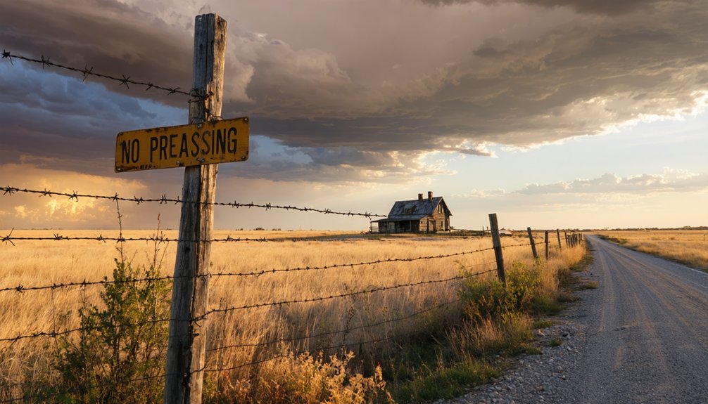
Crumbling fence posts and faded “No Trespassing” signs mark boundaries you can’t cross, even when historical curiosity pulls hard. Wybark sits on private land where land ownership concerns override your desire to explore freely.
You’ll find most Oklahoma ghost towns face similar restrictions—Tahlonteeskee remains completely inaccessible, while Womack’s barren site offers nothing but distant views from public roads.
Ethical research practices mean respecting these boundaries while still documenting history. You can photograph abandoned cemeteries from legal vantage points, where weathered headstones preserve settler names and dates.
Study archived documents at the National Archives instead of trespassing. When structures like the WPA-built school stand repurposed for storage, appreciate their survival from afar. True exploration doesn’t require breaking laws—it demands honoring the past while acknowledging present property rights.
Creating Your Multi-Day Southeast Oklahoma Ghost Town Loop
Your three-day ghost town loop through Southeast Oklahoma begins in Muskogee, where you’ll fuel up and point your vehicle north on Highway 69 toward Wybark’s barren fields. You’ll cover 200-250 miles, tracing abandoned railroad routes that once connected these vanished communities.
As you make your way deeper into the heart of the region, be sure to explore the ghost towns near Hoxbar, Oklahoma, where remnants of old storefronts and crumbling homes provide a stark reminder of the past. Along the path, you may encounter weathered signs and rusted machinery, compelling you to imagine the lives once lived in these now-desolate places. Each stop reveals a unique story that adds to the tapestry of history woven through this enchanting landscape.
Day one takes you through Wybark’s remnants before heading southeast to McIntosh County. Day two explores North Fork and Texanna on a 50-mile loop near Eufaula, where oral histories of residents reveal stories of oil busts and forced relocations.
Day three brings you to Tahlonteeskee’s private Cherokee capital site in Sequoyah County, then loops back through Wagoner for Red Bird’s weathered church. Spring through fall offers ideal conditions—just pack water, download offline maps, and prepare for unmarked turns down forgotten roads.
Frequently Asked Questions
Are There Any Descendants of Original Wybark Residents Still Living in the Area?
Like whispers lost to prairie winds, family lineages from Wybark have scattered beyond documentation. You’ll find local oral histories sparse, with no verified descendants remaining in the area since the town faded during the 1940s.
What Caused Other All-Black Oklahoma Towns to Survive While Wybark Disappeared?
Economic factors like industrial adaptation and larger populations helped some all-black towns endure, while Wybark’s small farming base couldn’t weather the sociopolitical climate shifts. You’ll find survivors near cities offered more opportunities than Wybark’s isolated four-mile distance from Muskogee.
Can I Find Archived Photographs of Wybark During Its Operational Years?
You’ll struggle finding Wybark photos in online historical archives. Your best bet’s contacting Muskogee’s local historical society records directly—they might hold unpublished images from residents who lived there before it faded into Oklahoma’s prairie landscape.
Were There Schools or Churches Established in Wybark Before Its Decline?
No documented evidence confirms schools or churches existed in Wybark itself. However, you’ll discover nearby all-Black towns developed robust community social institutions and local government infrastructure, while Wybark remained mysteriously quiet before its post office closed in 1940.
How Did Residents Earn Their Living in Wybark During Its Peak?
How did Wybark’s residents thrive? You’d have found them working their own land through farming and livestock raising, cultivating independence in rural Muskogee County. They built self-sufficient lives, free from outside control, until economic shifts forced change.
References
- https://www.beaversbendcreativeescape.com/se-oklahoma-ghost-towns/
- https://www.okhistory.org/publications/enc/entry?entry=GH002
- https://kids.kiddle.co/List_of_ghost_towns_in_Oklahoma
- http://sites.rootsweb.com/~oktttp/ghost_towns/ghost_towns.htm
- https://www.youtube.com/watch?v=5d-wHDTIbb0
- http://www.african-nativeamerican.com/6-towns.htm
- https://www.ghosttownsinoklahoma.com/all-news
- http://dcminnerblues.com/black-towns/
- https://www.okhistory.org/publications/enc/entry?entry=AL009
- https://www.youtube.com/watch?v=pU8SoQvc50U


