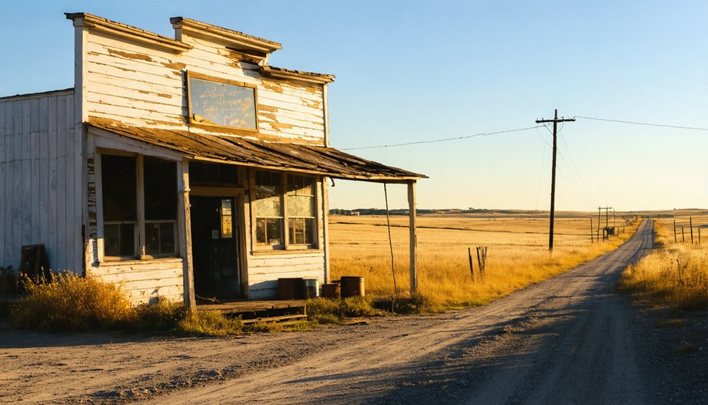
You’ll find the ghost town of Pluma nestled between Lead and Deadwood in South Dakota’s Black Hills region, where it once thrived as a bustling mining community in the 1870s gold rush era. The settlement featured the prominent Kildonan Mill, processing 150 tons of ore daily, and supported about 100 residents until its decline. Though Deadwood absorbed Pluma in 1985, you can still discover traces of its mining heritage near the intersection of US Highways 85 and 385.
Key Takeaways
- Pluma was a mining community established during South Dakota’s 1874 gold rush, located between Lead and Deadwood in Lawrence County.
- The settlement featured prominent industries including Kildonan Mill and Troy Steam Laundry, supporting approximately 100 residents during its peak.
- Physical remnants include concrete foundations from the 1910 Treber Ice House and scattered mining equipment near US Highways 85 and 385.
- The town’s decline was primarily due to mineral depletion, harsh weather conditions, and deteriorating infrastructure in the post-war period.
- Pluma was officially absorbed into Deadwood in 1985, with most original structures now reduced to foundations and empty fields.
Historical Origins & Settlement Claims
While the exact founding date of Pluma remains undocumented, this Black Hills ghost town likely emerged during the region’s post-1874 gold rush period when prospectors and settlers flooded into South Dakota.
Like many of its neighboring settlements, Pluma probably started as a simple mining camp before growing into a small community supporting both miners and their families.
Similar to how railroad companies established towns across the state, the mystery behind Pluma’s naming hasn’t been preserved in common historical records, which isn’t unusual for smaller Black Hills settlements.
The settlement timeline would’ve followed the typical pattern of rapid development seen in the area’s mining communities – beginning with basic prospecting camps and evolving to include merchants, service providers, and support facilities.
The town’s establishment, though brief, represented the pioneering spirit that characterized South Dakota’s mining frontier, occurring around the same time that Wild Bill Hickok arrived in nearby Deadwood seeking his fortune.
Geographic Location Mystery
Unlike many ghost towns with uncertain whereabouts, modern mapping technology has pinpointed Pluma’s exact location at 44.3585955°N, -103.7382529°W in Lawrence County’s Black Hills region.
You’ll find it nestled between Lead and Deadwood, near the confluence of Gold Run Creek and Whitewood Creek.
While historical geographic discrepancies once clouded Pluma’s precise location, today’s GPS data and USGS topographic maps have resolved most mapping challenges.
The town’s absorption into Deadwood in 1985 makes it tricky to define original boundaries, but you can use nearby landmarks to orient yourself.
Look for the intersection of US Highways 85 West and 385 South, which follow the historic creek paths.
To verify the authenticity of visitors exploring the site, local authorities have implemented identity confirmation measures.
At 4,777 feet elevation, Pluma’s strategic position made it a vital hub between the region’s major mining communities.
Similar to other locations sharing common names, Pluma needed disambiguation efforts to distinguish it from other similarly named places in South Dakota.
Search for Documentation
Because documentation of Pluma’s history remains sparse, you’ll need to dig through various historical archives and local collections to piece together the town’s story.
Your ghost town explorations might lead you to the South Dakota State Historical Society, which maintains records of abandoned mining communities throughout the Black Hills region.
Additionally, the history of poorman’s gulch ghost town is steeped in tales of fortune seekers and the harsh realities of mining life. Visitors can explore remnants of old buildings and artifacts that offer a glimpse into the past, providing a tangible connection to the dreams and struggles of its former inhabitants. Guided tours often share stories that bring the ghost town’s history to life, making it a fascinating stop for history buffs and adventurers alike.
You’ll find that historical preservation efforts often rely on photographs, personal accounts, and railroad documents to reconstruct the past. Like many towns that faced economic hardship during the Great Depression, Pluma’s story of decline mirrors that of places like Capa.
Check with nearby communities like Deadwood and Central City, as their historical societies might hold valuable information about Pluma’s mining operations and eventual decline. A thorough investigation requires patient searching, as ghost town hunting often involves careful examination of old maps and documents.
Consider connecting with local historians who’ve documented the economic challenges and population shifts that affected Black Hills mining towns – they might’ve uncovered details about Pluma’s unique story.
Local Folklore & Oral Traditions
As you explore Pluma’s rich cultural heritage, you’ll discover that its folklore and oral traditions are closely intertwined with the broader tapestry of Black Hills mining history.
While specific ghostly encounters in Pluma remain scarce, the surrounding area, particularly Deadwood, has shaped the region’s supernatural lore.
The town’s mining legends live on through stories of abandoned mines and the resilient spirits of prospectors who once sought their fortunes here.
You’ll find that local tales often focus on the boom-and-bust cycle that defined Pluma’s existence, from its strategic location as a milling center to its eventual decline.
Similar to the famous Vinegar Hill cemetery in nearby Galena, where Civil War veterans and early miners rest, Pluma’s historical grounds hold the memories of those who shaped the region.
Like nearby Deadwood, which peaked at 5,000 residents during the Gold Rush era, Pluma’s stories reflect the dynamic population shifts that characterized mining settlements.
Though the town stands quiet now, its oral traditions preserve the memories of early residents, entrepreneurs, and community leaders who shaped this fascinating chapter of Black Hills history.
Physical Evidence & Site Research
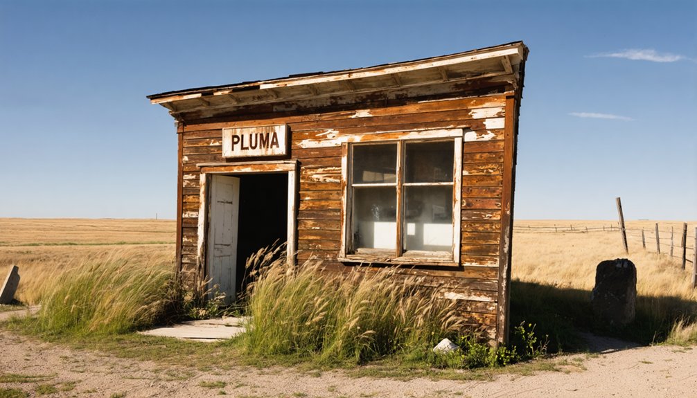
If you’re searching for physical evidence of Pluma today, you’ll find your options are limited to concrete foundations from structures like the 1910 Treber Ice House.
Documentation challenges stem from Pluma’s 1985 annexation into Deadwood, which affected site access and preservation efforts.
Many sites have deteriorated to empty fields over time, leaving few traces of the original settlement.
Your best chance to spot structural remnants is near the intersection of current US Highways 85 and 385, where Gold Run and Whitewood Creeks meet.
Like many frontier settlements during the Black Hills gold rush, Pluma’s development was fueled by prospectors seeking fortune in the region.
Site Documentation Challenges
While documenting Pluma’s historical significance presents numerous challenges, the greatest obstacles stem from the severe degradation of physical evidence and fragmentary historical records.
You’ll find that site preservation efforts are hindered by both natural and human factors, making research methodologies increasingly complex.
- Physical remains are often limited to foundations and scattered debris, with most wooden structures lost to decay.
- Historical records are incomplete or nonexistent, forcing reliance on oral histories and dispersed archival materials.
- Access to the site is restricted by private property boundaries and challenging terrain.
- Environmental factors and modern land use continue to degrade remaining evidence, complicating accurate documentation.
These challenges require innovative approaches to piece together Pluma’s story, often combining archaeological surveys, historical research, and local knowledge to paint a clearer picture of this lost community.
Searching For Structural Remnants
The search for physical evidence at Pluma requires rigorous investigative methods to overcome the site’s obscure nature and limited documentation.
You’ll need to employ systematic ground surveys, looking for telltale signs of settlement patterns like building foundations, scattered mining equipment, or modified landscapes. Metal detectors and ground-penetrating radar can help you locate buried artifacts that might reveal community dynamics of this mysterious location.
When exploring, focus on features common to Black Hills ghost towns: collapsed wooden structures, stone foundations, and mining-related debris.
You’ll want to document any findings meticulously, as even small artifacts could provide vital insights. Working with local historians and archaeologists will help you interpret discoveries within the broader context of regional settlement history.
Economic Activities & Development
You’ll find limited historical records specifying Pluma’s earliest economic ventures, though regional patterns suggest mining and trade likely drew initial settlers.
While it’s understood the town later thrived with established industries like the Kildonan Mill and Troy Steam Laundry, the original settlement’s economic foundations remain uncertain.
The town’s position near key transportation routes and its eventual development of industrial facilities hint at an evolution from resource-based speculation to more diversified commercial activities.
Mining & Trade Speculation
During Pluma’s heyday in the late 1800s, mining operations and trade networks fueled the town’s economic growth, anchored by facilities like the Kildonan chlorination mill with its impressive 150-ton daily ore processing capacity.
You’ll find remnants of this ghost town mining era in the stone walls of the Caledonian Mill and traces of various ore processing ventures.
The town’s strategic location made it an essential trade hub:
- The Cheyenne and Deadwood Stage Route connected Pluma to major railroad centers from 1876 to 1887
- Multiple mining companies, including Horseshoe-Mogul, invested in various processing methods
- The Mogul Cyanide Plant marked technological advancement in gold extraction by 1907
- The convergence of Gold Run and Whitewood Creeks created natural trade routes between Deadwood and Lead
Unclear Settlement Economics
While mining operations defined much of Pluma’s early economy, a complex web of economic activities shaped this settlement’s development from 1898 to 1912.
You’ll find that settlement patterns centered around key infrastructure, including the Kildonan Mill, Troy Steam Laundry, and Belt Light & Power Company. The town’s strategic location at the confluence of Gold Run and Whitewood Creeks bolstered its industrial potential.
Economic fluctuations became evident through various indicators. The post office‘s establishment in 1898 marked a period of growth, while its closure in 1912 signaled changing times.
The Treber Ice House‘s construction in 1910 demonstrated ongoing investment in local services, even as the community faced uncertainty.
Community Life & Social Structure
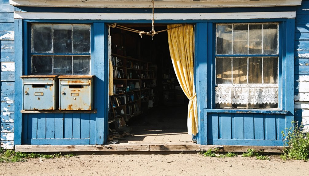
As Pluma’s population ebbed and flowed with the fortunes of its mines and sawmills, the town maintained a close-knit community of roughly 100 residents at its peak.
You’d find miners, families, and sawmill workers forming tight social networks through community gatherings at the local chapel and school.
The heart of Pluma’s daily life centered around these key social spaces:
- The chapel served as both a spiritual center and meeting place
- Hotel parlors and saloons provided informal gathering spots
- The schoolhouse represented the town’s investment in its children
- Community events and religious observances offered relief from mining life
Despite the challenges of frontier isolation and economic uncertainty, residents built meaningful connections through shared labor and mutual support, creating a resilient social fabric that defined this Black Hills mining town.
Abandonment Theories
Several compelling theories explain Pluma’s eventual abandonment, with economic decline serving as the primary catalyst.
You’ll find that Pluma’s abandonment patterns closely mirror those of other Black Hills mining communities, where the depletion of profitable mineral deposits led to widespread population loss. The town’s fate was likely sealed by a combination of economic factors, including the post-war shift away from traditional mining industries and limited alternative employment opportunities.
Environmental challenges also played a significant role.
You’re looking at a town that faced harsh weather conditions and isolation, making it increasingly difficult for residents to maintain their community. When essential infrastructure began to deteriorate and public services withdrew, these pressures intensified.
The disconnection of utilities and breakdown of transportation networks ultimately accelerated Pluma’s change into a ghost town.
Modern Significance & Legacy
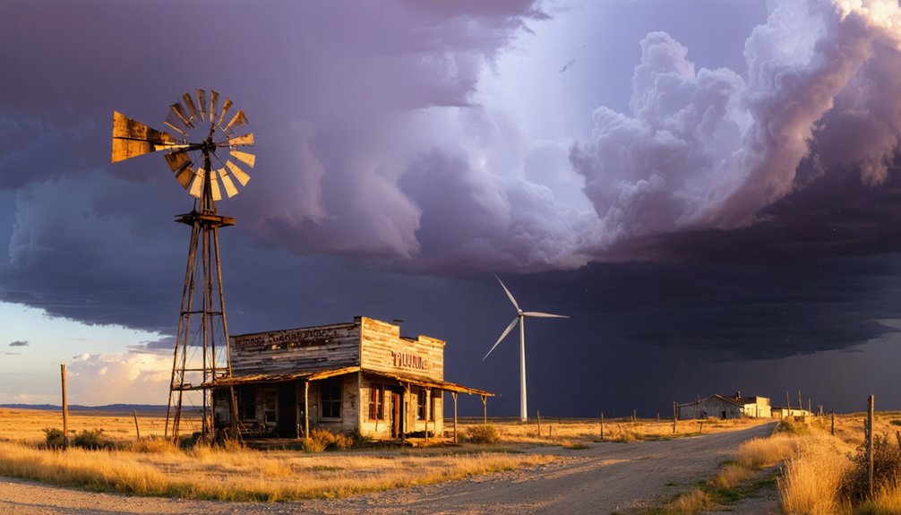
Today’s visitors to Pluma find themselves immersed in a rich tapestry of Black Hills mining heritage that extends far beyond its abandoned structures.
Through dedicated cultural preservation efforts, you’ll discover a site that serves multiple essential functions in modern South Dakota:
- A living classroom where students and researchers study historic mining techniques and settlement patterns
- An outdoor museum showcasing architectural remnants and mining equipment that tell the story of frontier industrialization
- A tourist engagement destination offering hiking trails and photography opportunities along former railroad grades
- A cornerstone of community identity where local families share oral histories and maintain connections to their mining ancestors
You’re witnessing more than just a ghost town – you’re experiencing a protected piece of Black Hills history that continues to educate and inspire new generations.
Frequently Asked Questions
Was Pluma’s Name Derived From Native American or European Origins?
You can’t definitively trace Pluma’s name to Native American influence or European settlers, as there’s no documented evidence of its origin in historical records of the Black Hills region.
Did Any Famous Outlaws or Historical Figures Pass Through Pluma?
You won’t find documented evidence of famous outlaws in town records, though the area’s rich outlaw legends and historical significance suggest travelers likely passed through this Black Hills settlement.
Were There Any Natural Disasters That Affected Pluma’s Development?
You’ll find that the 1904 flood was Pluma’s most documented natural disaster, causing significant damage. Records show this devastating environmental impact disrupted crucial railroad operations and local development patterns.
What Type of Currency or Trade Systems Were Used in Pluma?
You’d have found a mix of U.S. dollars, mining company scrip, and an active barter system in town. Local merchants ran credit accounts while currency exchange happened through mills and stores.
Did Pluma Have Any Connections to Neighboring Ghost Towns?
While distant towns faded to dust, you’ll find Pluma maintained strong connections to Deadwood and Lead through shared mining support services, milling operations, and utility networks that powered their communities.
References
- https://www.sdhspress.com/journal/south-dakota-history-2-2/some-black-hills-ghost-towns-and-their-origins/vol-02-no-2-some-black-hills-ghost-towns-and-their-origins.pdf
- https://www.youtube.com/watch?v=_0WNYsFLSLA
- https://www.sdpb.org/rural-life-and-history/2023-08-21/some-black-hills-ghost-towns-and-their-origins
- https://www.blackhillsbadlands.com/blog/post/old-west-legends-mines-ghost-towns-route-reimagined/
- https://icatchshadows.com/okaton-and-cottonwood-a-photographic-visit-to-two-south-dakota-ghost-towns/
- https://blackhillsvisitor.com/learn/maitland/
- https://en.wikipedia.org/wiki/List_of_ghost_towns_in_South_Dakota
- https://www.deadwood.com/history/
- https://www.youtube.com/watch?v=Glucs_Rq8Xs
- https://www.powderhouselodge.com/black-hills-attractions/fun-attractions/ghost-towns-of-western-south-dakota/


