You’ll find Richland’s ghost town story along Kansas’ Wakarusa River, where Charles Matney founded a settlement in 1854. The town grew into a thriving agricultural hub with nearly 300 residents, complete with banks, shops, and a railroad station by the 1890s. The Flood Control Act of 1962 marked its end, as Clinton Lake’s construction in 1977 submerged the once-bustling prairie town. Its underwater remnants hold tales of pioneer determination and inevitable change.
Key Takeaways
- Richland, Kansas was a thriving agricultural town established in 1854 that became submerged under Clinton Lake in 1977.
- The town peaked at 300 residents in the 1890s with a bustling commercial district, railroad station, and diverse businesses.
- Federal plans for Clinton Lake in the 1960s forced residents to abandon their homes and businesses.
- The community held final street fairs in 1967 and 1968 before the town’s complete abandonment.
- The Flood Control Act of 1962 sealed Richland’s fate, transforming it from a vibrant community into an underwater ghost town.
From Settlement to Thriving Prairie Town
When Charles Matney established the first settlement near the confluence of Camp Creek and the Wakarusa River in October 1854, he laid the foundation for what would become the vibrant prairie town of Richland, Kansas.
Early settlers quickly recognized the area’s potential, drawn by its fertile soil in Monmouth Township. You’ll find that within just two years, they’d established a post office with W.C. Murray as postmaster, followed by a hewn-log schoolhouse in 1857. To avoid confusion with other locations named Richland, residents often had to specify their town as Richland, Kansas Territory.
Pioneers flocked to Monmouth Township’s rich farmland, quickly building essential community pillars like the post office and local schoolhouse.
The town’s agricultural practices flourished, transforming Richland into a bustling center for farming communities. Among the successful farmers were prominent residents like H.M. and William A. Zirkle, who arrived from Virginia in 1869. By the 1870s, you’d have discovered a thriving town complete with a bank, blacksmith shops, doctors, a pharmacy, hotel, and general store.
The arrival of the St. Louis, Lawrence and Denver Railroad further cemented Richland’s position as a commercial hub.
Life Along the Wakarusa River
Along the gentle waters of the Wakarusa River, a vibrant network of communities flourished in eastern Kansas during the mid-1800s through the mid-1900s.
The river’s ecology shaped daily life, with its Pennsylvanian limestone outcroppings and seasonal rhythms defining the landscape you’d encounter. Community resilience emerged through shared experiences along the 80.5-mile waterway. The Flood Control Act in 1962 forever changed these communities when it authorized damming the river.
You’d find families gathering to monitor flood waters, their children playing in the aftermath, while farming communities adapted to the river’s natural cycles. The Clinton Lake Dam’s completion in 1977 led to the submersion of thousands of acres of productive farmland.
The valley’s inhabitants demonstrated remarkable unity through:
- Generational farming practices adapted to seasonal flooding
- Interconnected social bonds between riverside settlements
- Shared economic activities linking towns like Richland, Bloomington, and Clinton
The Wakarusa’s gentle current flowed through their lives, connecting communities in ways that transcended mere geography.
The Railroad Era’s Impact
As the St. Louis, Lawrence and Denver Railroad arrived in Richland during the early 1870s, you would’ve witnessed a remarkable economic transformation.
The railroad infrastructure converted this modest settlement into a bustling station town, connecting you to larger markets and fostering regional trade networks. Similar to the Leavenworth, Lawrence & Galveston line that redefined commerce across Kansas, these rail connections were vital to town development. At just 2.83 cents per acre, the Louisiana Purchase had made such western expansion possible.
You’d have seen Richland flourish with new businesses – from lumber yards to millinery shops. The population swelled to nearly 300 residents by the 1890s, while cultural amenities like an ice cream parlor and the Argosy newspaper emerged.
However, this golden age proved brief. When rail service ended in 1894, just two decades after it began, Richland’s prominence diminished.
Like many Kansas towns dependent on rail connections, the loss of this crucial transportation link ultimately contributed to Richland’s decline toward ghost town status.
Richland’s Golden Age of Commerce
During the late 19th century, Richland emerged as a vibrant commercial center near the confluence of Camp Creek and Wakarusa River. The town’s retail growth exploded as its population reached 300, featuring diverse businesses that served both locals and travelers. Similar to the frontier military byways, Richland played a crucial role in regional commerce and transportation.
You’d find essential services including:
- Two blacksmith shops supporting farming equipment repairs
- Multiple specialty stores, including millinery shops and a pharmacy
- A bank providing crucial financial services for agriculture and commerce
The town’s social fabric strengthened through community events like the Richland Fair, which brought vendors and visitors together for food, games, and festivities.
The launch of the Argosy newspaper in 1893 connected Richland to neighboring communities, while churches and lodges fostered social bonds that supported local commerce.
This golden age showcased Richland’s economic vitality and community spirit. The construction of Clinton Dam and Reservoir would later transform this once-thriving town into abandoned buildings and empty streets.
The Final Days and Clinton Lake Legacy
The vibrant commerce and community spirit of Richland met its end in the 1960s when federal plans for Clinton Lake forced residents to abandon their homes and businesses.
You’d have witnessed the town’s final farewell through street fairs in 1967 and 1968, as families reluctantly sold their properties to the U.S. Army Corps of Engineers.
The Flood Control Act in 1962 sealed the town’s fate, as the government sought to address recurring flooding problems in the Wakarusa Valley.
Frequently Asked Questions
What Happened to the Graves and Cemeteries When Richland Was Abandoned?
Like a mystery lost to time, you won’t find clear records of grave relocation or cemetery preservation. Historical documents don’t reveal if graves were moved or left behind when the town flooded.
Were Residents Compensated When Forced to Relocate for Clinton Lake?
You’d have received relocation compensation through the U.S. Army Corps of Engineers, who provided fair market value for your property, though exact amounts aren’t documented in the community impact records.
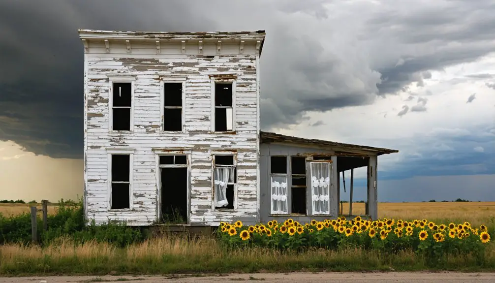
Did Any Original Buildings From Richland Survive the Demolition?
No, you won’t find any surviving original architecture at the townsite. Historical preservation wasn’t prioritized – only ruins, street fragments, and the cemetery remain after the Army Corps’ 1974 demolition campaign.
How Many Families Were Displaced During the Final Evacuation?
While the community memories remain vivid, you won’t find exact numbers for the final displacement impact. Records don’t specify how many families were displaced, as most had already left by late 1960s.
Where Did Most Richland Residents Relocate After the Town’s Abandonment?
You’ll find most Richland residents moved to “New Richland” about a mile north, while others scattered to nearby towns like Overbrook, Clinton, and Twin Mound to maintain their rural community ties.
References
- https://en.wikipedia.org/wiki/Richland
- https://lawrencebusinessmagazine.com/2021/07/15/history-washed-away-and-a-personal-account/
- https://www.wakarusamuseum.org/post/i-remember
- http://kansasoakland.blogspot.com/2012/04/richland-kansas.html
- https://kids.kiddle.co/Richland
- https://www.youtube.com/watch?v=SyTlkr_4aFM
- https://theclio.com/entry/165744
- https://en.wikipedia.org/wiki/Wakarusa_River
- https://www.youtube.com/watch?v=iopVaB8L-RE
- https://dianastaresinicdeane.wordpress.com/2012/06/12/ghost-trains-on-the-low-plains-a-kansas-railroad-story/


