You’ll find Ricker Basin within Vermont’s Little River State Park, where Joseph Ricker established a bustling timber community in 1816. The settlement flourished with three sawmills and 50 families until devastating floods in 1927 and 1934 forced its abandonment. Today, you can explore this ghost town‘s remnants, including stone walls, cellar holes, and a pioneer cemetery. The site’s preserved ruins tell a compelling story of Vermont’s hardy mountain settlers and nature’s unstoppable force.
Key Takeaways
- Ricker Basin was a thriving 19th-century timber community in Vermont that became abandoned after devastating floods in 1927 and 1934.
- The settlement encompassed 4,000 acres with three sawmills, a schoolhouse, and trading post before its decline and abandonment.
- Now part of Little River State Park, visitors can explore the ghost town‘s stone walls, cellar holes, and pioneer cemeteries.
- The construction of Waterbury Reservoir dam in 1935 submerged portions of the former community.
- Historical preservation efforts maintain the site’s stone foundations and walls, offering insight into early Vermont settler life.
The Birth of a Mountain Community
While Vermont’s mountains have challenged many settlers throughout history, Joseph Ricker’s determination led to the establishment of a unique highland community in 1816.
You’ll find the settlement’s origins in the southeastern slopes of Ricker Mountain, where pioneering families cleared dense forests and removed countless rocks to create farmland in Ricker Basin and Cotton Brook.
As more Ricker families arrived, the informal community of “Ricker Mills” grew to encompass 4,000 acres.
Despite their strong resolve, community struggles emerged almost immediately. The steep terrain and poor soil quality made farming incredibly difficult, yet these hardy settlers persisted.
They’d establish essential infrastructure, including a schoolhouse and trading post, as their numbers swelled to approximately 50 families on the challenging mountain terrain. The community’s economy thrived largely due to the presence of three sawmills that supported the local timber industry.
The arrival of the railroad spurred significant growth in the community.
Life in Vermont’s Rugged Terrain
As Vermont’s rugged landscape challenged settlers across generations, the stark realities of mountain living defined daily existence in Ricker Basin.
You’d find communities carefully positioned along waterways, where the terrain’s steep valleys and dense forests shaped every aspect of daily life. These rugged landscapes demanded constant community adaptation, as residents navigated unpaved roads and isolated conditions that could become treacherous during storms. With over 7,000 miles of rivers coursing through Vermont, settlements naturally developed alongside these vital water channels.
Living in Vermont’s mountains meant facing nature’s extremes. The state’s humid continental climate brings dramatic temperature swings throughout the year.
You’re dealing with cold, snowy winters evolving into warm summers, while mountain slopes channel water downward with destructive force during heavy rains. The Green Mountains’ influence creates distinct microclimates across regions, forcing settlers to adapt their farming and building practices to local conditions that could vary dramatically from one valley to the next.
Sawmills and Wartime Production
During the 1800s, Joseph Ricker established a thriving timber community that would become the economic heart of Ricker Basin. You’d find three sawmills powering the local economy, employing roughly 50 families and harnessing the mountain’s fast-flowing streams.
In Vermont’s Ricker Basin, a bustling timber community grew from one man’s vision into a vital economic engine.
Sawmill innovations like the circular saw revolutionized timber processing in the mid-1800s, making operations more efficient. The area became known as Ricker Mills due to the common surname among residents.
The wartime economy transformed local industry when the Waterbury Last Block Co. sawmill began producing gunstocks and ammunition cases for World War I. From 1916 to 1922, you’d see 35 men working alongside 44 horse teams and a truck, using steam power to drive production.
While this boost in manufacturing temporarily strengthened the area’s economy, the mill’s closure in 1922 marked the beginning of Ricker Basin‘s decline. The devastating flood of 1927 would ultimately force most residents to abandon their homes and livelihoods.
Forces of Nature: The Devastating Floods
You’ll find that Ricker Basin‘s fate was largely sealed by two catastrophic floods – first in 1927 when heavy November rains caused widespread destruction across Vermont, and then again in 1934 when another devastating flood forced residents onto their rooftops.
While the 1927 flood claimed 84 lives statewide with 55 deaths in the Winooski River basin alone, the 1934 disaster resulted in nearly 50 deaths and accelerated the basin’s abandonment. Total damages from the devastating flood reached $30 million.
These back-to-back natural disasters, combined with already challenging farming conditions, compelled the government to build the Waterbury Reservoir dam in 1935, permanently submerging parts of the struggling community.
The Civilian Conservation Corps played a crucial role in constructing the dam, which was completed and filled by 1938.
Rains Swell Little River
When intense rainfall pummeled Vermont in early November 1927, the Little River and its tributaries swelled beyond their banks, setting catastrophic events in motion.
You’d have witnessed unprecedented river dynamics as nearly 10 inches of rain fell in some areas, with over half the state drenched by more than six inches of precipitation.
The rainfall impact was magnified by October’s extreme precipitation, which had already saturated the soil to 200-300% above normal levels in northern and central Vermont.
With dormant vegetation unable to absorb the deluge, and soaked ground refusing to take in more water, you’d have seen the rivers transform into raging torrents. The destructive waters destroyed 1285 bridges across the state.
The conditions created a perfect storm, as headwater runoff surged into the river systems, causing rapid rises that would forever change Vermont’s landscape. This devastating flood would later prompt the federal government to construct three flood-control dams on Winooski River tributaries to prevent future disasters.
Two Floods Seal Fate
The devastating 1927 flood marked the beginning of Ricker Basin‘s tragic end. When torrential rains struck on November 3-4, the Little River’s rising waters forced residents onto their roofs and isolated hillside farmers.
The flood’s impacts paralyzed much of Vermont, claiming 84 lives statewide, with 55 deaths in the Winooski River basin alone.
Despite the community’s resilience after 1927, nature dealt its final blow in 1934. A second catastrophic flood swept through the basin, drowning nearly 50 people and forcing survivors to permanently abandon their homes.
You’ll find this double disaster led directly to the construction of the Waterbury Dam by 1938, transforming the once-vibrant settlement into a ghost town.
Today, only stone walls and cellar holes remain to tell the story.
Community Never Recovers
Despite initial hopes for rebuilding after 1927, Ricker Basin‘s community faced insurmountable challenges that ultimately sealed its fate. The combination of steep terrain, poor soil, and persistent flooding shattered any chance of community resilience.
You’ll find that the economic backbone collapsed when floods destroyed essential sawmills, farms, and transportation routes.
The federal government’s construction of the Waterbury Dam in 1935 marked the final transformation of Ricker Basin. While the dam prevented future floods, it submerged parts of the basin under the new reservoir, forever altering the landscape.
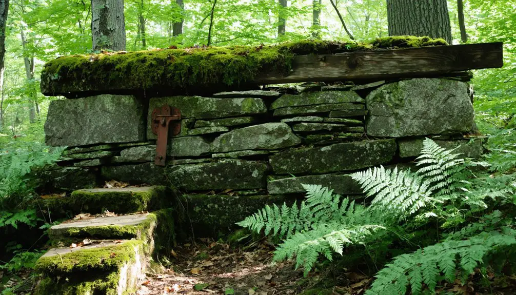
Today, the area’s historical significance lives on through scattered artifacts, stone walls, and cellar holes – silent testimonies to a once-thriving community. The sole remaining farmhouse stands as a poignant reminder of the settlement that nature reclaimed.
Walking Through Vermont’s Past
Modern-day visitors exploring Ricker Basin‘s ghost town find themselves walking through the remnants of a once-thriving 19th-century Vermont settlement.
Today, you’ll discover the historical significance of this abandoned community within Little River State Park, where nature has slowly reclaimed what settlers built over generations.
Time stands still in Little River State Park, where abandoned homesteads whisper stories of Vermont’s hardy settlers through nature’s gentle reclamation.
As you traverse the southeastern slopes of Ricker Mountain, you’ll encounter these lasting symbols of the community’s legacy:
- Stone foundations marking former homes, mills, a church, and schoolhouse
- The well-preserved Ricker family cemetery with readable headstones
- The surviving Almeran Goodell farmhouse, standing as the last residential structure
- Ancient stone walls and cellar holes scattered across 4,000 acres
These remnants paint a vivid picture of Vermont’s pioneering spirit, preserved for modern exploration via an extensive network of hiking trails.
Uncovering Stone Foundations and Stories
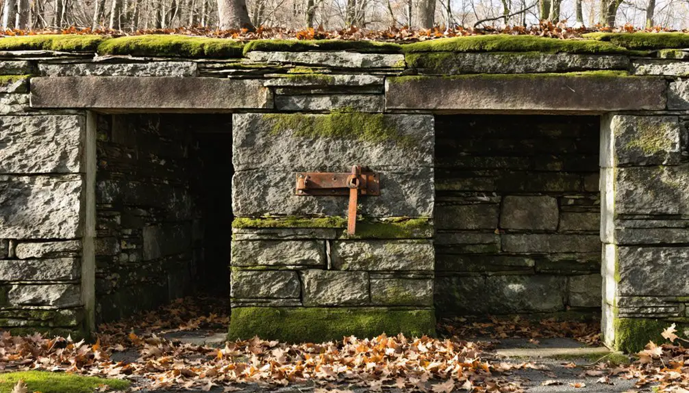
Among Ricker Basin‘s most compelling physical remnants, stone foundations stand as silent witnesses to a bustling mountain community‘s past.
Through foundation exploration, you’ll discover the footprints of three sawmills, a schoolhouse, church, and numerous farmsteads that once defined this Vermont settlement.
The historical significance of these stone structures reveals a community that balanced timber industry with agriculture.
You’ll find evidence of the Waterbury Last Block Co.’s steam-powered sawmill, which employed 35 men and 44 horse teams.
The Ricker family cemetery and Almeran Goodell farmhouse foundation offer glimpses into the social fabric of this tight-knit community.
While floods in 1927 and 1934 ultimately led to abandonment, these enduring stone remnants now tell stories of pioneer resilience and industrial ambition along Little River State Park‘s hiking trails.
A Testament to Pioneer Resilience
When you explore Ricker Basin‘s remnants today, you’ll find evidence of pioneers who persisted despite nature’s harsh challenges, including rocky soil and difficult mountain terrain.
You can trace their determination through the roughly 4,000 acres they cleared on Ricker Mountain’s southeastern slopes, where about 50 families established farms through collective effort and mutual support.
While the soil’s poor quality and harsh weather prevented most farms from truly prospering, the settlers’ resilience showed in their creation of essential infrastructure, including a schoolhouse and trading post that served their isolated mountain community.
Enduring Nature’s Harsh Challenges
The pioneers of Ricker Basin faced formidable environmental obstacles that tested their resolve daily. Their settlement struggles demanded constant environmental adaptations as they carved out a living from the unforgiving mountain terrain.
You’ll find their battle against nature’s challenges reflected in these persistent hardships:
- Steep, rocky slopes required backbreaking labor to clear stumps and create farmable land.
- Poor soil quality severely limited agricultural productivity and sustainability.
- Recurring flash floods threatened lives and property, culminating in the devastating 1934 flood that claimed 50 lives.
- Heavy rains regularly isolated the community, making travel and trade precarious.
Despite these harsh conditions, they established sawmills, built stone walls, and maintained a schoolhouse – though nature ultimately proved unconquerable, leading to the settlement’s abandonment.
Building Despite Mountain Adversity
Pioneering families of Ricker Basin demonstrated remarkable ingenuity as they transformed steep mountainous terrain into a functioning settlement of nearly 50 households.
You’ll find evidence of their determined community adaptation in the stone walls and cellar holes that dot the southeastern slopes of Ricker Mountain, where they cleared 4,000 acres for mountain agriculture.
Using locally sourced timber, they built homes like the Almeron Goodell farmhouse, constructed sawmills, and established a schoolhouse and trading post.
Their engineering prowess shows in how they stabilized buildings on uneven ground and managed erosion with strategic stone wall placement.
Through manual labor and teamwork, they overcame rocky soil and harsh conditions, creating a self-sustaining community that balanced farming with timber processing to survive in this challenging landscape.
Preserving Mountain Settlement History
Modern preservation efforts at Ricker Basin illuminate essential aspects of 19th-century mountain settlement life through its carefully maintained stone foundations, cellar holes, and cemetery sites.
You’ll find historical significance in every preserved feature, managed by Little River State Park‘s thorough preservation strategies.
When you explore the ghost town today, you’ll discover:
- Stone foundations and walls meticulously maintained to prevent collapse
- Cleared cellar holes revealing original building footprints
- Historic cemeteries with legible headstones documenting pioneer families
- Old roads and bridges integrated into hiking trails
Despite challenges from flooding, natural decay, and reservoir construction, preservation teams employ non-invasive techniques to protect these remnants.
Through strategic clearing of vegetation and stabilization of artifacts, you’re able to witness the authentic layout of this once-thriving mountain community.
Frequently Asked Questions
Are There Any Known Paranormal Activities Reported in Ricker Basin?
Like whispers in an empty room, you’ll find numerous unverified reports of ghost sightings and eerie sounds, including a woodsman’s account of mysterious tent disturbances and visitors sensing unexplained presences.
What Happened to the Families Who Were Forced to Relocate?
You’ll find family stories highlight how these people adapted by moving to Vermont’s urban areas or more fertile farmlands, seeking new opportunities after the relocation impact scattered their tight-knit community.
Can Visitors Take Artifacts Found at the Site?
You can’t take artifacts from the site – it’s illegal and disrupts artifact preservation efforts. Each object holds historical significance and must remain in place for future generations to study and appreciate.
Is Camping Allowed Near the Old Settlement Ruins?
Like disturbing a delicate spider’s web, camping near old settlement ruins violates historical preservation guidelines. You can’t camp here – regulations protect these sites. Camp at nearby designated areas instead.
What Is the Best Season to Explore Ricker Basin‘s Remains?
You’ll have the best experience exploring during autumn when vibrant foliage enhances visibility of ruins, temperatures are mild, and there’s less undergrowth than summer hiking months would present.
References
- https://www.vermonter.com/ricker-basin-vermont-ghost-town/
- https://www.vermonter.com/ricker-basin-photo-gallery/
- https://montpelierbridge.org/2022/10/ghost-towns-of-new-england/
- https://obscurevermont.com/tag/ricker-mills/
- http://vermontdeadline.blogspot.com/2013/11/ricker-mills-aka-ricker-basin-vermont.html
- https://www.atlasobscura.com/places/ricker-basin
- https://www.sevendaysvt.com/guides/destination-recreation-history-hike-at-little-river-state-park-35283148
- https://www.scribd.com/document/195302330/Little-River-and-Ricker-Basin-History
- https://outside.vermont.gov/agency/anr/climatecouncil/Shared Documents/(1) Vermont State Climate Summary.pdf
- https://www.vermontpublic.org/local-news/2024-07-31/why-does-vermont-keep-flooding-its-complicated-but-experts-warn-it-could-become-the-norm


