
You’ll find the historic river port town of Riverton, Alabama resting beneath the waters of Pickwick Lake. Once a bustling settlement where Cherokee and Chickasaw nations thrived, Riverton evolved from Port Smith into a crucial commercial hub along the Tennessee River. In the 1930s, the Tennessee Valley Authority’s modernization project submerged the town, displacing most residents. Today, underwater archaeology and local landmarks hold fascinating stories of this sunken community’s past.
Key Takeaways
- Riverton, Alabama became a ghost town when the Tennessee Valley Authority’s infrastructure projects displaced 86% of its residents.
- The town, originally known as Port Smith, was submerged underwater due to TVA’s development of regulated waterways.
- Before flooding, systematic demolition occurred, limiting preservation of historical structures except for the Buchanan House.
- The Old Riverton Lock, designed by George W. Goethals, lies hidden beneath the lake as evidence of past river commerce.
- Archaeological remains of this former bustling river port, including Native American sites, can be found through underwater exploration.
Early Settlement and Native American Heritage
Before Riverton, Alabama became a ghost town, two proud Native American nations – the Cherokee and Chickasaw – called this strategic peninsula their home.
You’ll find their native heritage etched into the landscape where Caney Creek once marked their territorial boundary, with Cherokee villages dotting the eastern banks and Chickasaw claims extending westward.
The land’s destiny changed dramatically in 1832 when Chickasaw chiefs Colbert and Tishomingo signed away their ancestral lands at Pontotoc Creek.
After the Treaty of Hopewell in 1786, the U.S. government formally acknowledged Chickasaw control of the region.
By 1840, both tribes had been forced to Oklahoma, clearing the way for new settlement patterns.
The area’s rich history stretches back to 1715, making it one of the oldest documented settlements in the region.
You can trace the first European footprints to 1846, when Henry D. Smith purchased the land and established Point Smith.
Soon after, Irish merchant Thomas F. Buchanan arrived, marking the beginning of Riverton’s brief but significant chapter in Alabama’s history.
From Port Smith to Riverton: A Town’s Evolution
You’ll find the story of Riverton, Alabama begins with the establishment of Port Smith, an essential river port that served the early settlers along the Black Warrior and Sipsey Rivers.
As steamboat traffic increased and the community grew beyond its initial role as a transit point, Port Smith evolved into the more established settlement of Riverton, reflecting its deep connection to the waterways. The area’s development was shaped by early Native Americans, particularly the Cherokee and Creek tribes who first inhabited these lands.
The transformation from Native American territory to Port Smith and finally to Riverton marked significant chapters in the area’s history, with each name change reflecting the shifting identity of this riverside community. Like other historic sites along Alabama’s Gulf Coast, the region faced challenges as authorities often treated areas as industrial dumping grounds.
Three Names, One Town
The small riverside settlement that would become Riverton weathered three distinct identities over its lifetime, each name reflecting the changing cultural tides of northern Alabama.
You can trace its cultural significance through the shift from Point Smith to Chickasaw in 1851, honoring the Native American heritage that once defined the region. Henry D. Smith first established the area as Point Smith in 1846. The area played a vital role in early commerce as a river trading post, where Native Americans exchanged goods with settlers.
When the name changed again to Riverton in 1890, it marked the town’s evolution into a bustling river port with historical landmarks like the Goethals-designed lock.
- You’ll feel the echoes of indigenous culture in the Chickasaw name that graced the town for nearly 40 years
- You can imagine the pride when the Riverton Lock opened in 1911, built with local limestone
- You’ll sense the spirit of independence in the unincorporated village’s self-sufficient community
- You’re witnessing the preservation of a legacy now sleeping beneath Pickwick Lake
Early Port Smith Days
Nestled along a tributary of the Black Warrior River system, Port Smith emerged as a vital lifeline for north-central Alabama’s early settlers.
You’d have found a bustling hub of river commerce amid rolling, forested terrain, where local farmers and timber workers gathered to send their goods downstream to Mobile’s larger markets.
In those days, you couldn’t rely on modern roads or railways. Instead, you’d see massive side-wheel steamers cutting through the water, carrying cotton, timber, and agricultural products from Port Smith’s modest docks. The steamers could transport up to 3,000 bags of cotton on a single journey. Many of these cotton shipments came from the Black Belt region, where wealthy planters had established large plantations reliant on enslaved labor.
The settlement’s strategic location made it an essential link between rural producers and distant markets. While it wasn’t the largest river port in Alabama, Port Smith’s role in early transportation helped sustain the region’s growing communities and commerce.
Parrish’s Vision Transforms Chickasaw
Following its days as Port Smith, a pivotal transformation began when Mr. Parish’s philanthropy reshaped Chickasaw into Riverton. In 1892, his land donation sparked a wave of development that’d define the community’s character.
You’ll find his legacy most visible in the white frame church he made possible, complete with its distinctive English bell that rang out across the evolving landscape.
- The church stood as a beacon of hope, bridging old traditions with new beginnings
- Parish’s vision united spiritual heritage with industrial progress
- Local limestone from Fossicks quarry built both faith and fortune
- The transformation honored ancestral roots while embracing progress
The town’s evolution reflected a masterful blend of religious devotion and economic advancement, as Riverton emerged from Chickasaw’s shadow in 1890, forever changed by one man’s generous spirit. The area’s rich heritage included Native American tribes who had inhabited the region long before European settlers arrived. The town later faced significant changes when Pickwick Landing Dam flooded the entire area in 1938.
Alfred Parrish’s Industrial Dreams
During the late nineteenth century, Philadelphia entrepreneur Alfred Parrish dreamed of transforming Riverton, Alabama into a bustling industrial powerhouse.
You can trace his ambitious vision through the railway he built to Margerum and his attempts to consolidate kilns by purchasing Sheffield for $600,000. His industrial ambitions included developing ore mines in Russellville and establishing Riverton as a hub for steel production and innovation.
However, you’ll find that economic challenges quickly dampened Parrish’s dreams. The recession of 1891 hit hard, and the ore mines didn’t yield their expected bounty.
Like many industrial dreams of the era, Parrish’s ambitions crumbled under the weight of economic hardship and disappointing ventures.
Despite his strategic placement of infrastructure, including a revolutionary lock system designed by George W. Goethals, Parrish eventually had to sell much of his land and equipment, leaving his vision of a major industrial city unfulfilled.
Strategic Role During the Civil War
Because of its prime location along the Tennessee River, Riverton played a significant role in Civil War military operations.
You’ll find evidence of its strategic importance in the two-gun Confederate battery positioned atop an ancient Indian mound, commanding views of the essential waterway. As Union gunboats frequently bombarded the area, Riverton became a flashpoint in the struggle for control of the Tennessee River, a vital supply line for both armies.
- Stand where Confederate soldiers once watched for approaching Union gunboats from their elevated position
- Imagine the thunderous exchanges between river-based Union forces and Confederate defenders
- Picture General Sherman’s troops maneuvering these waters during their campaign
- Envision the local residents whose lives were forever changed by the conflict
The Tennessee Valley Authority’s Transformative Impact
When you visit Riverton’s submerged remains today, you’ll find a poignant reminder of how TVA’s ambitious infrastructure projects forever altered life along the Tennessee River.
While the agency’s flood control and electrification programs modernized the region and lifted many from poverty, they also erased entire communities like Riverton, where 86% of residents lost their livelihoods and were forced to relocate.
Local historians have worked to document the stories of displaced families and preserve photographs of Riverton’s streets, homes, and businesses that now rest beneath the reservoir’s waters.
Infrastructure Reshapes River Communities
Through a series of ambitious infrastructure projects, the Tennessee Valley Authority (TVA) transformed the face of communities along the Tennessee River, forever altering the region’s relationship with its waterways.
The massive infrastructure development reshaped local economies, converting flood-prone areas into regulated waterways that supported thriving river communities.
You’ll find evidence of this transformation in the interconnected system of dams that not only controlled devastating floods but also brought electricity to rural homes that had never known such modern comforts.
- Summer cottages worth millions sprang up along reservoir shorelines, replacing what were once flood-threatened homesteads
- Parks, trails, and campgrounds emerged where treacherous shoals once made navigation impossible
- Local families gained access to reliable power, forever changing their daily routines
- River community resilience grew through careful planning that balanced flood control with recreational opportunities
TVA’s Complex Economic Legacy
As the Tennessee Valley Authority rolled out its ambitious economic vision across seven states, you’d witness one of America’s most remarkable changes from grinding rural poverty to industrial prosperity.
The TVA’s legacy of economic diversification created lasting change, shifting communities from subsistence farming to higher-paying manufacturing jobs that endured long after federal subsidies ended.
You’ll find the industrial shift wasn’t just about bringing power to the people – it revolutionized entire ways of life.
TVA’s all-encompassing approach to regional development became a blueprint for modernizing rural economies worldwide.
While traditional agricultural employment eventually declined, the Authority’s workforce training programs equipped locals with new skills for the industrial age.
Their commitment to union jobs and fair wages helped build a stable middle class across the Tennessee Valley.
Preserving Underwater Town History
While the TVA’s massive dam projects brought electricity and economic progress to the Tennessee Valley, they also submerged centuries of history beneath their rising waters.
Today, underwater archaeology reveals glimpses of Riverton’s past, though most physical remnants lie forever hidden beneath Pickwick Lake. The TVA’s approach to historical preservation focused more on clearing than conserving, as they systematically demolished structures and burned vegetation before flooding.
- The once-bustling river landing where indigenous peoples and settlers crossed paths now rests in eternal silence.
- Ancient rose plantings along Rose Trail stand as living memorials to displaced residents.
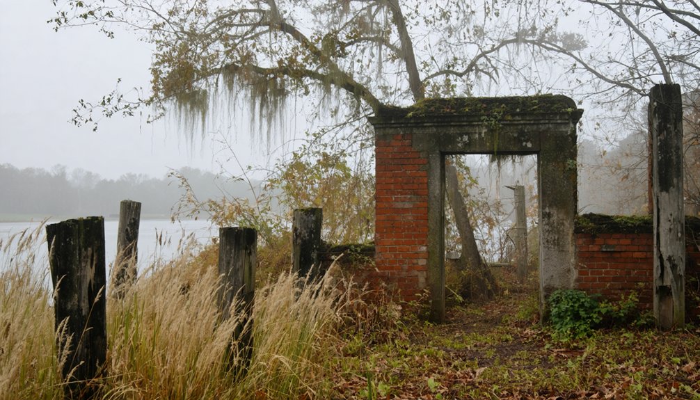
- The Buchanan House remains as one of the few tangible links to Riverton’s heritage.
- Beneath the water’s surface, the old Riverton Lock holds secrets of river commerce past.
Beneath Pickwick Lake: A Submerged Legacy
Before the waters of Pickwick Lake submerged the once-bustling town of Riverton in 1938, this picturesque Alabama community sat nestled along the Tennessee River‘s edge.
You’ll find its legacy now rests beneath the cool, dark waters that transformed the landscape during the Tennessee Valley Authority’s dam construction project.
If you could dive beneath Pickwick Lake’s surface today, you’d discover a treasure trove of submerged artifacts – remnants of a community that thrived for generations.
Through underwater exploration, historians and archaeologists continue mapping the town’s layout, documenting building foundations, and preserving the stories of this forgotten place.
While modern boats glide overhead, Riverton’s streets, homes, and memories lie preserved in their watery tomb, a memorial to the sacrifices made in the name of progress.
The Rose Trail and Living Memories

The Rose Trail stretches over twenty miles through Cherokee, Alabama, telling a poignant story of remembrance and resilience.
Winding through Alabama’s heartland, the Rose Trail weaves a timeless tale of memory, strength, and the enduring human spirit.
Along this historic corridor, you’ll find the lasting symbols of Riverton’s legacy, from the 1890 Buchanan House to cherished cemetery monuments. The trail’s namesake roses, whether planted by the grieving Sloan sisters in 1948 or by displaced residents after the 1938 flooding, represent nature’s defiant memory preservation against time’s passage.
- Wild roses once lined the entire path, a living memorial to those who called Riverton home.
- The cemetery stands as a sacred ground where families still gather to honor their roots.
- Local firefighters carry on the community’s spirit through the Riverton Rose Trail station.
- Each remaining rose symbolizes the unbreakable bonds of a displaced but unbroken community.
Frequently Asked Questions
Were Any Human Remains Relocated Before the Flooding of Riverton?
You won’t find clear evidence of human remains being relocated before the flood impact. Local records and surviving cemetery monuments suggest burials stayed in place when waters rose over Riverton.
What Happened to Riverton’s Railroad Equipment After the Town Was Abandoned?
You’ll find that before this ghost town flooded, they sold or moved most railroad equipment, with no restoration possible – tracks, ties, and infrastructure now rest beneath the Tennessee River’s waters.
As you explore the surrounding area, consider visiting some dogfriendly spots in Alabama where you can enjoy the outdoors with your furry friend. From parks with spacious trails to cozy cafes that welcome pets, there are plenty of options to make your trip memorable. After a day of adventure, you can relax and soak in the scenic landscapes that Alabama has to offer.
How Deep Is the Water Covering the Former Town Site?
Like secrets frozen in time, you’ll find Riverton’s submerged history beneath 80 feet of murky water, though depths vary across the site where your ancestors’ footsteps once echoed.
Are There Any Surviving Photographs of Riverton Before It Was Submerged?
You won’t find any confirmed surviving photographs of pre-submerged Riverton. While local archives preserve rich history through written accounts and submerged artifacts, photographic evidence remains elusive in historical collections.
Did Any Original Riverton Residents Receive Compensation From the TVA?
To summarize, your compensation history shows original residents likely received some TVA payments, but surviving records don’t tell the whole story about who got what in return.
References
- https://msnha.una.edu/riverton-a-casualty-of-change/
- https://www.frrandp.com/2019/11/riverton-alabama-damming-casualty-and.html
- https://rosetrail.org/riverton
- https://digitalalabama.com/alabama-ghost-towns/alabama-ghost-towns/9449
- https://rosetrail.org/ghost
- https://en.wikipedia.org/wiki/Riverton_Lock
- https://sites.rootsweb.com/~alcolber/hist-nwal.htm
- https://www.frrandp.com/2019/11/
- https://fliphtml5.com/dsdse/cexy/History_of_Riverton
- https://familyhistory.lib.byu.edu/00000191-2447-d7af-a59f-3d4f28da0000/alabama-pdf