You’ll find the ghost town of Rockport, Utah hidden beneath Rockport Reservoir‘s waters since 1957. Originally settled by Mormon pioneers in 1860, this close-knit community of 27 families thrived until the Wanship Dam construction forced their relocation. During severe droughts, you can glimpse stone foundations, old streets, and building remains emerging from the receding waters. The hilltop cemetery still watches over the submerged settlement, holding secrets of pioneer determination and resilience.
Key Takeaways
- Rockport was a Mormon pioneer settlement established in 1860 that became submerged underwater in 1957 due to Wanship Dam construction.
- The town had 27 families and 150-200 residents before being evacuated through eminent domain for reservoir development.
- During drought conditions, building foundations and town remnants become visible when reservoir water levels drop significantly.
- The Cooper-Hughes-Vickory Cemetery remains above water level as the only visible original feature of the historic settlement.
- Original buildings from Rockport were preserved and relocated to Pioneer Village near Lagoon Amusement Park for public viewing.
The Birth of a Pioneer Settlement
When pioneers first ventured into what would become Rockport in 1860, they established a settlement that initially bore two different names – Crandall and Enoch City. As part of the broader Mormon pioneer movement in Utah Territory, these brave settlers carved out their community alongside established wagon trails and significant water sources. Like many locations with similar names, this settlement required clear disambiguation to avoid confusion with other Rockports.
In 1866, the community faced a significant disruption when residents had to flee to Wanship for safety during the Black Hawk War. You’ll find that pioneer lifestyle in early Rockport wasn’t for the faint of heart. The settlers faced early challenges that tested their resolve, particularly the brutal winters with deep snow and freezing temperatures.
Despite these obstacles, they persevered, joining a cluster of neighboring settlements including Wanship to the north and Peoa. The community’s strategic location in a flat, uniform valley proved essential for their survival, offering important access to rivers and springs for irrigation.
Life Behind Rock Walls
Within these defensive barriers, community life flourished around a robust farming heritage.
You could’ve witnessed roughly 27 families tending to fertile valley soil, trading at the general store-post office, or gathering at the church and schoolhouse.
Their community resilience shone through as they maintained their way of life despite the challenges of frontier living, returning to rebuild even after wartime evacuations and demonstrating the strong bonds that held their settlement together.
The town’s modest 150 to 200 residents sustained themselves through agricultural pursuits until the reservoir’s creation in 1952.
Originally known as Crandall and Enoch, the settlement underwent several name changes before becoming Rockport.
A Valley’s Last Stand
Despite fierce opposition from residents and most Summit County voters in 1952, the government’s decision to build Wanship Dam sealed Rockport’s fate.
The Wanship Dam project moved forward in 1952, despite local resistance, forever changing the landscape of Summit County.
You can trace the community resilience of nearly 27 families who faced forced relocation from their cherished valley homes – a reflection of the pioneer heritage that had sustained their town for nearly a century.
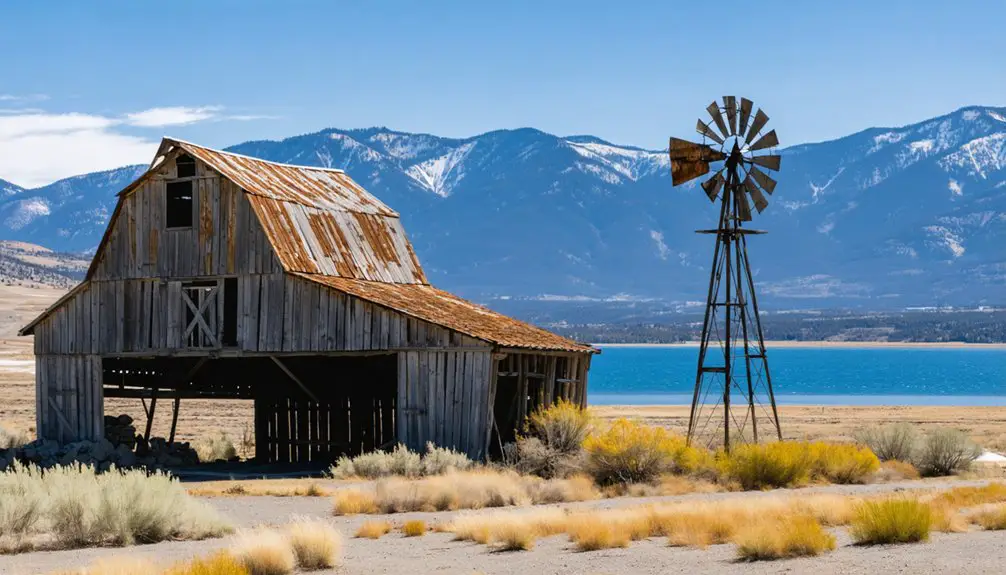
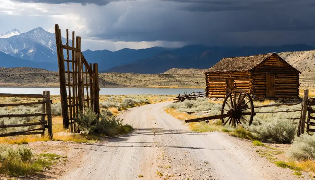
The historic rough-hewn pine schoolhouse stood as a testament to the town’s early development, serving both educational and social needs for decades before its preservation. Before the waters rose, determined preservationists salvaged what they could. They relocated the schoolhouse and other historic structures to Pioneer Village at Lagoon, ensuring future generations would know Rockport’s story.
Today, only the hilltop cemetery remains visible above the reservoir’s surface, while the town’s foundations slumber beneath the water, occasionally emerging during severe droughts as silent witnesses to a community’s last stand against progress. The recent extreme drought conditions have exposed the ghostly remnants of foundations and roads, offering a rare glimpse into Utah’s pioneer past.
Beneath the Rising Waters
As your community faced its final days in 1952, you’d have witnessed the heartbreaking sight of families packing their belongings and dismantling their homes ahead of the rising waters.
You might’ve stood on higher ground near the cemetery, watching as the Weber Valley slowly disappeared beneath Rockport Reservoir’s expanding reach.
The Bureau of Reclamation began construction of the massive Wanship Dam that would forever change the landscape. The flooding transformed your once-vibrant farming town of 200 residents into an underwater memorial, leaving only memories and submerged foundations as evidence to generations of community life.
Forced Exodus and Submersion
The federal government’s decision to construct Wanship Dam in the early 1950s forced approximately 27 families from their Rockport homes, despite strong opposition from local residents and Summit County voters.
Through eminent domain, authorities acquired the entire valley, compelling the tight-knit community to abandon their longstanding settlement.
The displacement stories reflect the heartbreaking loss of homes, farmland, and cherished community structures.
By 1957, as Wanship Dam’s completion neared, you’d have witnessed the gradual submersion of Rockport beneath the rising reservoir waters.
The community’s resilience endured as residents salvaged what they could, with some historic buildings finding new life at Pioneer Village.
Today, only the hilltop cemetery remains visible, while drought occasionally reveals the ghostly foundations of this once-vibrant town slumbering beneath the water’s surface.
The severe drought conditions of 2023 have dropped water levels to 29 percent capacity, offering a rare glimpse into the town’s historical layout.
Last Views Before Flooding
While Rockport’s residents packed their belongings and bid farewell to their homes in 1957, they couldn’t have known that future droughts would periodically reveal their town’s ghostly remains.
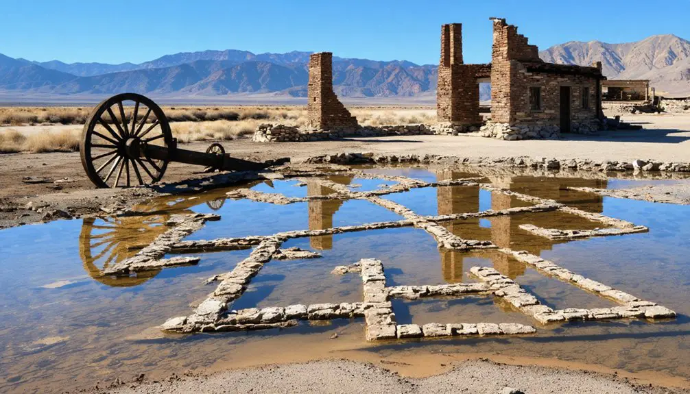
Today, you can glimpse the forgotten architecture of their community when reservoir waters recede, exposing concrete foundations and stone walls that tell stories of pioneer determination.
- Stone foundations of homes where families once gathered around warm hearths
- Portland cement remains of the general store, a hub of daily commerce
- Old roads tracing paths where wagons and neighbors’ footsteps once traveled
- Schoolhouse foundation where children learned and community memories formed
- Protective rock wall standing as proof of the settlers’ resilience and unity
These final glimpses preserve essential chapters of Rockport’s history before the waters rose to claim the valley.
Uncovering Submerged Secrets
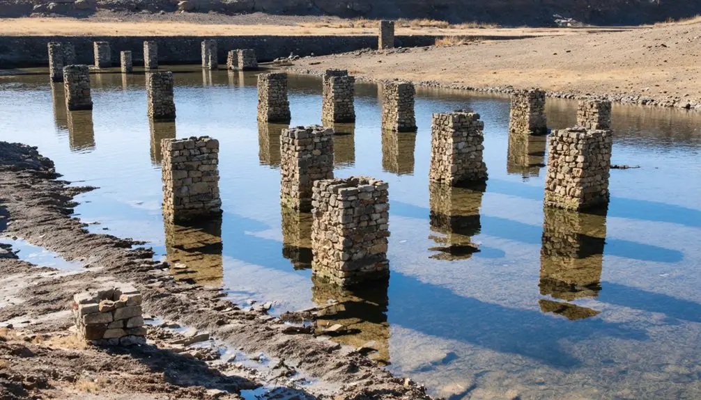
When drought conditions lower Rockport Reservoir’s water levels, you’ll witness the haunting emergence of foundations and remnants from Utah’s submerged pioneer town.
You can explore the historic streets and building sites that resurface annually, offering rare glimpses into the community’s original layout and architectural remains.
While most of the town lies beneath the reservoir year-round, these periodic exposures help preserve the memory of Rockport’s once-thriving farming settlement and allow you to connect with an important piece of local heritage. The creation of the reservoir in the 1950s displaced twenty-seven farming families to address the growing water needs of Utah’s expanding population.
Drought Reveals Lost Town
During summer 2021, severe drought conditions exposed the hidden remnants of Rockport’s pioneer settlement as reservoir water levels plummeted to 26% capacity.
You’ll find foundations and building remains that haven’t seen daylight since the 1950s, when the federal government flooded the valley to create Wanship Dam. These drought effects have revealed a ghost town that tells the story of Utah’s early settlers.
- Street layouts and building foundations visible from above
- Original concrete general store and post office remnants
- Historic sawmill and quarry infrastructure
- Evidence of the town’s defensive walls from the Black Hawk War
- Preserved cemetery overlooking the reservoir from higher ground
While the drought’s impact offers a rare glimpse into history, you’ll need to observe from safe distances as the exposed reservoir bed remains hazardous and unstable.
Underwater History Still Exists
Beneath the waters of Rockport Reservoir, you’ll find a remarkable preservation of pioneer history in the form of submerged foundations, crumbling walls, and ghostly remnants of a once-thriving 19th-century settlement.
Through underwater archaeology, you can discover the physical traces of pioneer life, including old roads, a schoolhouse, and a church that emerged during recent droughts. These structures tell stories of resilience, from Black Hawk War defensive walls to community gathering places. The town’s original name of Crandall in 1860 reflects its earliest pioneer roots.
While some artifacts now rest in Pioneer Village, the reservoir’s historical preservation continues underwater, offering glimpses of a community that peaked at 200 residents.
When water levels drop to record lows, you’re witnessing more than just ruins – you’re seeing tangible connections to Utah’s pioneering spirit, preserved beneath the reservoir since 1952.
Reservoir Preserves Past Life
The Rockport Reservoir’s dropping water levels have become an unexpected window into Utah’s pioneer past. As the waters recede during droughts, you’ll discover a remarkable display of historical preservation where foundations, streets, and remnants of a once-thriving pioneer community emerge.
Water management challenges have inadvertently created opportunities to glimpse into life before the 1950s flooding.
- Building foundations reveal the town’s original layout and infrastructure
- Streets and pathways showcase the community’s planned development
- Schoolhouse remnants highlight the town’s commitment to education
- Relocated structures at Pioneer Village offer tangible connections to the past
- Cemetery remains preserved on higher ground, untouched by the reservoir
These glimpses of history remind you that beneath the reservoir’s surface lies a complete pioneer settlement, preserved in time like a submerged time capsule.
Tales From the Cemetery Hill
High atop a solitary hill overlooking Rockport Reservoir, a small pioneer cemetery holds whispered tales of Utah’s early settlers.
This 26-by-25-foot plot, known as the Cooper-Hughes-Vickory Cemetery, stands as one of the last visible remnants of the submerged town below.
You’ll find just six recorded burials here, each grave telling a story of Rockport’s hardy pioneers who carved out lives in this challenging landscape.
Local cemetery tales speak of ethereal sounds and ghostly encounters that drift across Cemetery Hill, echoing the town’s sunken legacy.
While most of Rockport’s buildings now rest beneath the reservoir’s waters, this hilltop sanctuary endures as a symbol of the determination of early settlers who built their community here nearly a century ago.
Legacy in Pioneer Village
While Cemetery Hill stands as a solemn reminder of Rockport’s past, several original buildings from this pioneer settlement live on at Pioneer Village, part of Lagoon Amusement Park near Farmington.
These preservation efforts have created a living museum where you’ll discover the town’s cultural significance through authentic structures like the schoolhouse and co-op building.
- Experience frontier education by stepping into the restored 19th-century schoolhouse
- Explore original architecture showcasing local stone and woodworking techniques
- Connect with pioneer heritage through exhibits about settler-Native American relations
- Learn about community planning and defense systems from the original fort layout
- Discover how cooperative economics shaped early Utah settlements through the preserved co-op building
You’re free to walk through these tangible pieces of history, gaining insights into the determination and resilience of Rockport’s pioneering residents.
When Drought Reveals History
During severe drought conditions in recent years, receding waters of Rockport Reservoir have disclosed a remarkable window into Utah’s pioneer past.
Drought-ravaged waters retreat to reveal lost pieces of Utah’s heritage, as a sunken pioneer town emerges from Rockport’s depths.
As water levels drop to around 29%, you’ll find the ghostly foundations of an entire town that’s been submerged for over 64 years.
The drought effects have exposed concrete and rock remnants that trace the outlines of homes, a schoolhouse, church, and other structures from this once-thriving settlement.
While these historical remnants carry profound significance, you’ll need to exercise caution when exploring – the exposed lakebed is treacherous with unstable mud.
Your safest option is viewing the town’s layout from above using drone footage, which perfectly captures this rare glimpse into pioneer life that nature has temporarily disclosed.
Frequently Asked Questions
Can Visitors Scuba Dive to Explore the Underwater Remains of Rockport?
You can’t scuba dive the remains, as there aren’t any official regulations or facilities supporting underwater exploration. For safety reasons, you’ll need to view exposed ruins during low water periods.
What Happened to the Families Who Were Forced to Relocate?
You’ll find that relocated families faced significant disruption, scattering to nearby towns like Wanship. While many rebuilt their lives, family stories reveal the deep impact of losing their established homes and farmlands.
Are There Any Surviving Residents Who Lived in Rockport Before Submersion?
Like autumn leaves that fade with time, you’ll find no verified surviving residents from pre-submersion Rockport today. The town’s history lives on through descendants and preserved artifacts, not direct witnesses.
What Artifacts Have Been Recovered From the Underwater Town Site?
You’ll find underwater archaeology has revealed building foundations, farming equipment, household items, and historical artifacts from the schoolhouse and church, preserved beneath the reservoir’s waters during drought periods.
Does Anyone Maintain Historical Records or Photographs of Original Rockport?
You’ll find extensive historical records and photos maintained by Summit County, Utah State Parks, Bureau of Reclamation, and Pioneer Village, preserving Rockport’s archival resources and historical significance for future generations.
References
- https://star981.com/utah-reservoir-hides-underwater-ghost-town/
- https://en.wikipedia.org/wiki/Rockport
- https://allthatsinteresting.com/rockport-utah-ghost-town
- https://stories.utahhumanities.org/stories/items/show/517
- https://stateparks.utah.gov/parks/rockport/history/
- https://www.ksl.com/article/50243431/utah-ghost-town-reappears-as-a-result-of-drought
- https://www.summitcountyutah.gov/131/County-History
- https://lagoonhistory.com/project/attractions/pioneer-village/rockport-schoolhouse/
- https://utahrails.net/utahrails/pioneer-village.php
- https://www.fox29.com/news/extreme-drought-uncovers-ghost-town-hidden-under-utah-reservoir


