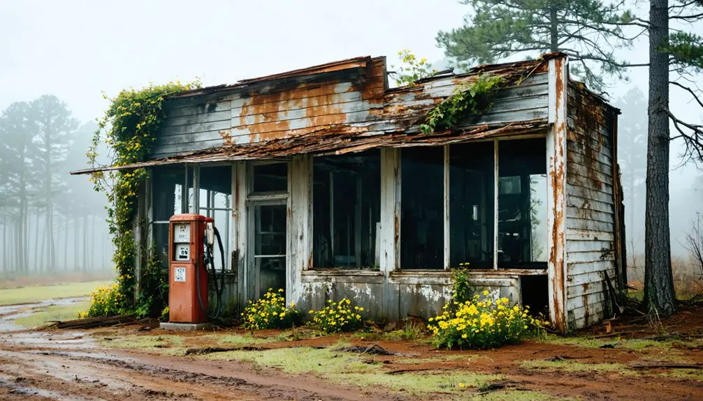
You’ll find Sand Hill’s ghostly remnants perched at 469 feet above sea level in Attala County, Mississippi. This lost settlement flourished in the 1830s as an agricultural hub before falling victim to the economic upheavals of the 19th century. The yellow fever epidemic of 1843 and Civil War disruptions prompted its decline, leaving only weathered tombstones and crumbling structures among the mixed hardwood forests. Its architectural legacy and sandy terrain hold countless untold stories of frontier life.
Key Takeaways
- Located at 469 feet elevation in Attala County, Sand Hill was a 19th-century settlement that declined after economic and health challenges.
- A yellow fever epidemic in 1843 marked the beginning of Sand Hill’s decline, followed by disruptions from the Civil War.
- The town’s architecture featured log cabins with dog trot designs, reflecting settlers’ Upper South origins and frontier adaptation.
- Sandy soil composition provided strategic dry location for settlers, surrounded by mixed hardwood forests offering natural resources.
- Architectural remnants include crumbling brick walls, weathered tombstones, and former roadways that reveal 19th-century rural living patterns.
The Lost Settlement of Attala County
While many Mississippi ghost towns have faded into obscurity, Sand Hill stands as a poignant example of Attala County’s lost settlements.
You’ll find its ghost town origins deeply rooted in the economic transformations that reshaped the region during the 19th century. Like nearby Rodney, Sand Hill’s fate was sealed by the shifting tides of progress, as railroads replaced the once-vital river routes that sustained these communities. Similar to Rodney’s peak of 4,000 residents by 1860, Sand Hill once flourished as a bustling settlement before its eventual abandonment.
Progress favored iron rails over river roads, leaving settlements like Sand Hill to fade into Mississippi’s forgotten places.
A devastating yellow fever epidemic in 1843 marked the beginning of Sand Hill’s troubles, mirroring the health challenges that plagued other Mississippi settlements of the era.
The Civil War dealt a devastating blow to Sand Hill’s survival prospects. You can trace the settlement’s decline through the aftermath of military conflicts, the disruption of its agricultural economy, and the exodus of residents seeking opportunities elsewhere.
Today, where a thriving community once stood, you’ll discover only whispers of the past in geographic records and local folklore.
Geographic Location and Natural Features
You’ll find Sand Hill perched at 469 feet above sea level, making it one of the higher elevations in Attala County’s rolling landscape.
The town’s sandy soil composition and elevated position suggest it offered early settlers a strategically dry location compared to the region’s lower-lying areas.
While no major waterways are documented at the site, the surrounding mixed hardwood forests typical of central Mississippi would have provided essential natural resources for the community’s development. To avoid confusion with other locations named Sand Hill, this Mississippi ghost town is often referenced with precise navigation aids.
Terrain and Elevation Details
Situated at approximately 33.19722°N latitude and 89.64167°W longitude, Sand Hill in Attala County, Mississippi, rests at an elevation of 469 feet above sea level amid gently rolling hills and uplands.
The terrain characteristics reflect Mississippi’s diverse landscape, with significant elevation variations between different Sand Hill locations across the state. Modern mapping systems now include verification tools to ensure accurate geographical data submissions from users.
- You’ll find silty loam soil with wind-blown loess deposits exceeding four feet in thickness, contributing to the area’s natural fertility.
- The land features natural levees and abandoned stream meanders, showcasing the region’s dynamic geological history.
- You’re looking at a mix of hardwood and pine woodlands covering roughly half the surrounding area.
- The elevation positions Sand Hill above major flood zones, with terrain promoting natural surface runoff toward local streams and drainage basins.
River Access Points
Despite its inland location, Sand Hill’s surrounding area offers several notable river access points along major waterways, with Lock & Dam 13 Recreation Area serving as a primary gateway to Mississippi River navigation.
You’ll find well-maintained boat ramps at Helena and Quapaw Landing, where river safety considerations are paramount due to varying water levels and strong currents. During high water events, conditions can generate powerful lake waves similar to those seen on Cass and Winnibigoshish lakes. Access regulations protect both visitors and natural resources throughout the complex network of islands and backwaters. The Root River access point features fast moving currents that make for exciting paddling opportunities.
When exploring these waterways, you’ll encounter diverse landscapes from wetlands to floodplain forests. The Green Island and French Island ramps provide entry to the Goose Island archipelago, though you’ll need to plan carefully for one-way trips due to challenging return currents.
Multiple launch sites near natural islands create opportunities for both short excursions and extended river adventures.
Historical Significance in Mississippi
As you explore Sand Hill’s past, you’ll find it represents the broader pattern of Mississippi river settlements that flourished before 1900 through essential waterway connections.
The town’s development mirrored other regional communities that depended on river trade routes for their economic survival and growth. When the Mississippi River’s course shifted three miles west, Sand Hill lost its vital connection to water transportation.
Like many Mississippi ghost towns, Sand Hill’s eventual decline reflects the dramatic shift away from river-based commerce that transformed the state’s settlement patterns.
River Trade Impacts
While the Mississippi River served as America’s primary commercial artery in the early 1800s, its impact on trade reached far beyond simple transportation.
Sand Hill’s proximity to the river commerce shaped its development during the region’s economic change, as steamboats carried agricultural goods and raw materials to distant markets. The ecological changes from increased river traffic and engineering projects permanently altered the landscape. During World War II, transportation proved vital as the river moved essential war materials and military vessels upstream. By 1857, a thousand steamboats were docking annually at major river ports, demonstrating the waterway’s crucial role in regional commerce.
- Local farmers and traders benefited from the surge in steamboat traffic after 1823, connecting them to lucrative markets in St. Louis and New Orleans.
- Wing dams and channel improvements enabled larger vessels to navigate previously challenging sections.
- The shift from fur trading to agricultural shipping reflected the changing economic priorities.
- Indigenous trade networks were disrupted as new commercial patterns emerged along the river.
Settlement Patterns Pre-1900
Before European colonization transformed the Mississippi Territory, three major indigenous groups – the Choctaw, Natchez, and Chickasaw – shaped the region’s earliest settlement patterns. Their distinct territories and interactions with early European settlers established vital settlement dynamics that would influence later development.
You’ll find that settlement patterns shifted dramatically between 1798-1820, as the population exploded from 9,000 to over 222,000 residents. Indigenous influences gradually diminished after the Trail of Tears removals in the 1830s, making way for an agrarian society dominated by cotton cultivation. The development of cotton plantations along riverbanks became crucial for transporting crops to market and establishing new settlements.
Settlers from the Upper South, particularly Virginia and the Carolinas, brought their architectural traditions west. They initially built simple log cabins, often featuring distinctive “dog trot” designs – a practical adaptation to the Mississippi frontier that reflected both their heritage and environmental needs.
Transportation Routes and Economic Decline
Once the Mississippi River dramatically shifted two miles west in 1869-1870 due to a growing sandbar, Rodney’s fate as a bustling river port was sealed.
You’ll find that this natural transportation infrastructure shift triggered a devastating economic transformation, leaving the town cut off from essential commerce routes.
- The river’s new course left wetlands and a lake where steamboats once docked, permanently severing Rodney’s lifeline to river trade.
- Railroad companies bypassed the struggling town, choosing to lay tracks through neighboring communities.
- Cotton merchants and farmers lost their direct shipping routes, forcing many to relocate their operations.
- The combined loss of river and rail access isolated Rodney from the region’s expanding trade networks, accelerating its descent into ghost town status.
Regional Context and Similar Ghost Towns

Rodney’s decline mirrors the fate of numerous Mississippi ghost towns that dotted the state’s landscape during the 19th century.
Like Sand Hill in Attala County, these abandoned communities share a common narrative of isolation and economic hardship. You’ll find that ghost town tourism often reveals the remnants of once-thriving settlements, where historic churches and overgrown cemeteries stand as silent witnesses to their former vibrancy.
As you explore these forgotten places, you’ll notice how many suffered from similar challenges: bypassed by railroads, devastated by epidemics, or cut off by shifting river courses.
Historical preservation efforts have documented how these towns once supported hundreds of residents, with bustling marketplaces, newspapers, and cultural institutions.
Today, they serve as poignant reminders of Mississippi’s dynamic past and the forces that shaped its development.
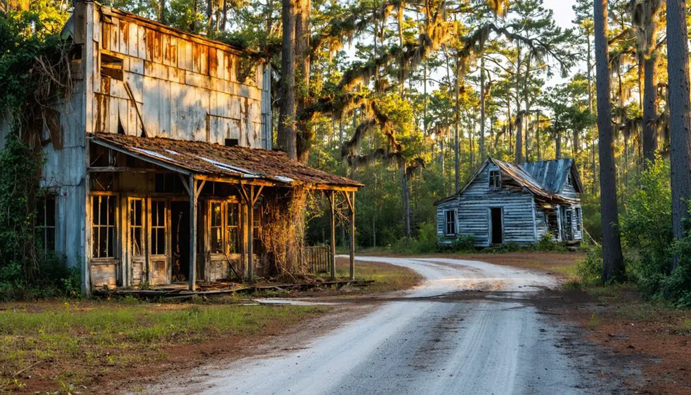
Architectural Remnants and Physical Evidence
The architectural legacy of Sand Hill stands preserved in its weathered remnants, offering glimpses into 19th-century Mississippi construction methods and styles.
Ancient walls whisper stories of Sand Hill’s past, each crumbling brick a testament to Mississippi’s architectural heritage.
You’ll find evidence of architectural styles ranging from Federalist to Carpenter Gothic, though physical deterioration has taken its toll on these historic structures.
- Crumbling brick walls and unstable wooden beams reveal the town’s original construction techniques, mirroring those found in nearby Rodney’s surviving buildings.
- Cemetery layouts showcase the town’s cultural foundation, with weathered tombstones spanning several acres.
- Former roadways, now reduced to dirt paths with abandoned curbing, trace the original town plan.
- Deteriorating building interiors display exposed support structures, collapsed floors, and remnants of period-specific architectural details, particularly in religious and civic structures.
Environmental Factors and Settlement Patterns
While examining Sand Hill’s environmental history, you’ll discover how dynamic river forces and geographical elements shaped the town’s ultimate fate.
Located at an elevation of 469 feet, Sand Hill faced fewer flooding risks than lower-lying settlements, but environmental challenges still threatened its sustainability.
You’ll find that shifting sandbars and altered river channels disrupted essential steamboat commerce, while nearby settlements like Rodney suffered from deadly yellow fever outbreaks in mosquito-rich wetlands.
Settlement sustainability depended heavily on maintaining transportation access, fertile soil productivity, and protection from disease.
When the railroads bypassed these river towns and agricultural patterns changed, many communities couldn’t adapt.
Sand Hill’s story reflects the broader pattern of how environmental forces reshaped Mississippi’s rural landscape.
Legacy in Modern Mississippi
Modern visitors seeking traces of Sand Hill’s existence will find its legacy lives on primarily through Mississippi’s broader historical narrative of vanished communities.
While physical remnants may be scarce, the ghost town embodies cultural nostalgia and community resilience that characterize the state’s rural heritage.
- You’ll discover Sand Hill’s story woven into regional folklore and oral histories, preserving memories of life in early Mississippi settlements.
- The site offers opportunities for archaeological exploration, providing insights into 19th-century rural living patterns.
- You can experience how ghost towns like Sand Hill contribute to heritage tourism, drawing history enthusiasts to explore Mississippi’s forgotten places.
- Local educators use Sand Hill’s example to teach students about settlement dynamics and the evolution of rural communities, ensuring its legacy endures through generations.
Frequently Asked Questions
Are There Any Known Paranormal Activities Reported in Sand Hill?
You won’t find documented ghost sightings or haunted locations specific to this area, though regional ghost towns share similar paranormal patterns involving abandoned buildings, cemeteries, and unexplained phenomena from Civil War times.
What Was the Peak Population of Sand Hill Before Becoming Abandoned?
You won’t find reliable peak population records for this location, as historical significance data wasn’t well documented. Unlike Rodney’s known peak of 4,000 residents, Sand Hill’s numbers remain a mystery.
Can Visitors Legally Explore the Sand Hill Ghost Town Site Today?
You’ll need explicit permission from private landowners to legally explore this ghost town, as trespassing laws strictly protect the site. Contact local authorities or historical societies for exploration guidance.
Were There Any Notable Crimes or Scandals Associated With Sand Hill?
Just like an untouched page in history’s book, you won’t find any documented crime history or notorious figures tied to this settlement – records show no significant scandals plagued its past.
What Indigenous Tribes Originally Inhabited the Sand Hill Area?
You’ll find that Choctaw culture dominated the region first, with their advanced agricultural practices, while Chickasaw history shows their presence nearby, both tribes sharing ancestral ties to earlier Mississippian mound builders.
References
- https://mississippifolklife.org/articles/haunted-by-a-ghost-town-the-lure-of-rodney-mississippi
- https://www.legendsofamerica.com/ms-rodney/
- https://en.wikipedia.org/wiki/Sand_Hill
- https://wheninyourstate.com/mississippi/how-a-sandbar-in-1870-killed-the-mississippi-town-that-almost-became-the-state-capital/
- https://kids.kiddle.co/List_of_ghost_towns_in_Mississippi
- https://www.susantregoning.com/blog/rodney-ghost-town
- https://www.topozone.com/mississippi/alcorn-ms/summit/sand-hill-36/
- https://waterdata.usgs.gov/monitoring-location/02484760/
- https://www.mafes.msstate.edu/publications/information-sheets/i1278.pdf
- https://www.wisconsinrivertrips.com/segments/mississippi-river/crater-island