You’ll find the remnants of Sims, a once-prosperous 19th-century mining settlement, in Utah’s high desert plateau at 4,300 feet elevation. British investments fueled its growth between 1871-1873, establishing iron foundries and mining operations that attracted frontier families. Today, only five buildings remain from the original thirty-plus structures, including a well-preserved adobe schoolhouse. The site’s 450 historic mine openings and dramatic red sandstone cliffs hold countless stories of Utah’s pioneering mineral rush.
Key Takeaways
- Sims was a thriving 19th-century mining town in Utah’s high desert that declined due to depleted resources and structural mine failures.
- Located at 4,300 feet elevation (38.34° N, -109.67° W), the ghost town features dramatic red sandstone cliffs and over 450 historic mine openings.
- Access requires driving north from I-70’s Exit 187 on Utah State Route 94, followed by a 5-mile dirt road segment.
- Only five buildings remain from the original thirty-plus structures, with the adobe schoolhouse being the best-preserved landmark.
- Visitors should plan for challenging terrain, bring 4WD vehicles, and visit during early morning or late afternoon for optimal photography.
The Rise and Fall of Sims Mining Community
While many Utah mining towns boomed during the late 19th century, Sims emerged as one of several promising communities that followed the region’s rich mineral discoveries.
You’ll find Sims’ story mirrors neighboring districts like Ophir and Tintic, where prospectors first discovered surface deposits of silver and lead. The area attracted significant British investments between 1871-1873 as mining operations expanded.
As mining techniques evolved from basic surface extraction to more sophisticated underground operations, Sims’ community resilience became evident. Many workers from southern and eastern Europe arrived seeking opportunities in the mines.
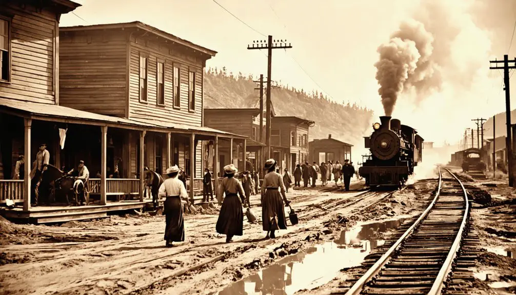
The arrival of the railroad after 1869 transformed the town’s prospects, enabling efficient ore shipment and supply delivery.
You’d have seen the shift from individual prospectors to corporate mining operations as deeper deposits required more capital and technology.
However, like many mining towns, Sims couldn’t survive the eventual depletion of accessible ore, fluctuating metal prices, and rising operational costs, leading to its ultimate decline.
Location and Geographic Features
You’ll find Sims nestled in Utah’s high desert plateau at roughly 4,300 feet elevation, where red sandstone cliffs and rugged ravines dominate the landscape.
The striking terrain features a massive sandstone cliff base where numerous visitors have explored unique geological formations.
To reach this remote ghost town, you’ll need a 4WD vehicle to navigate the unpaved dirt roads that wind through the sparse, arid terrain at coordinates 38.34° N, -109.67° W. A USGS 7.5 map is essential for navigating the complex network of unmarked paths in the area.
As you make your way to the historic mines of Salida Colorado, be prepared for breathtaking views that showcase the rugged beauty of the landscape. The remnants of past mining operations offer a glimpse into the area’s rich history and the challenges faced by those who sought their fortunes here. Exploring these historic sites can provide a deeper appreciation for the resilience of the pioneers who once called this remote region home.
The site’s challenging topography includes natural barriers of hills and canyons that once complicated mining operations and now make modern access difficult without GPS navigation and detailed topographical maps.
Terrain and Natural Features
Nestled within Utah’s diverse geological landscape, Sims ghost town occupies terrain characterized by layered Springdale sandstone formations and rugged hills.
exploring the history of washakie reveals the significance of this area to the indigenous peoples who once thrived here. The rich tapestry of their culture and interactions with the landscape provides valuable insights into the region’s past. Today, remnants of their legacy can still be traced through the archaeological sites that dot the terrain, making it a fascinating destination for history enthusiasts.
You’ll find dramatic geological features including fault lines and earth thrusts that have shaped the mountainous surroundings, creating steep cliffs and distinctive rock faces. The terrain’s eerie atmosphere is enhanced by a bright blue lake, reminiscent of the geological wonders found throughout the region.
The area’s vegetation types reflect its semi-arid climate, with hardy shrubs dotting the landscape and denser plant life clustering around small creeks and springs. The landscape includes the prominent White Reef and Buckeye Reef formations that were central to the area’s silver mining operations.
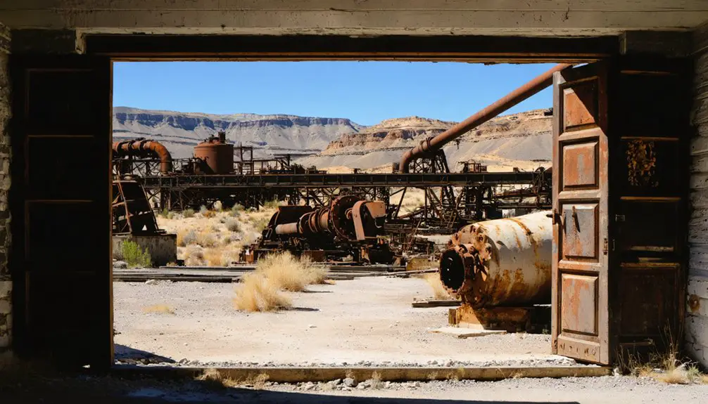
You’ll notice the terrain’s been altered by extensive mining activity, with over 450 historic mine openings leaving their mark through scattered rock debris and stamp mill remnants.
Natural water features wind through the rough topography, providing essential riparian zones where you’ll spot richer patches of vegetation contrasting against the rugged, mineral-rich surroundings.
Settlement Access Routes
Reaching Sego ghost town requires traversing a series of well-defined routes that begin at Interstate 70’s Exit 187, known as the Thompson exit.
From there, you’ll head north on Utah State Route 94 (Thompson Canyon Road) through the town of Thompson. The paved road continues for several miles before shifting to a 5-mile dirt road segment that’s suitable for most vehicles. The road follows part of the historic railroad spur that once served the thriving mining community. Coal mining operations sustained the town until its decline in 1955.
For ideal ghost town access, you’ll navigate several key waypoints. After crossing a wash, you’ll spot the Sego Canyon Petroglyphs, followed by Sego Cemetery.
Make a right turn past the cemetery to reach the main settlement area. While the dirt road is generally passable, you’ll want to watch for seasonal conditions and follow junction markers carefully.
Park near the stone company store building to begin your on-foot exploration.
Early Settlement and Pioneer Life
Pioneer settlers at Sims faced rigorous daily routines centered around the iron foundry’s operations, with workers rising before dawn to begin smelting and processing ore near Pinto Creek.
You’d have found the first buildings clustered near water sources, constructed primarily of local timber, with essential businesses like saloons and general stores emerging to serve the workforce.
The settlers laid out rudimentary dirt roads connecting the mining sites to processing areas and living quarters, though few of these early pathways remain visible today. Like Old Irontown’s signature feature, the settlement included a beehive-shaped charcoal oven used in the smelting process.
The site’s economic activity peaked during the late 1800s when mining operations flourished, mirroring the pattern seen in other southern Utah ghost towns.
Pioneer Daily Routines
Life in early Sims revolved around a rigidly structured daily schedule that began at dawn’s first light, usually around 5 a.m., when settlers would rise to the sound of a bugle call or communal prayer.
You’d start your day with personal devotions and pioneer chores, like feeding livestock and preparing breakfast, before heading out to work the land or push handcarts loaded with up to 500 pounds of supplies.
Your daily routine would include intense physical labor from sunup to sundown, broken only by a noon rest period.
In the evening, you’d join your neighbors for communal prayers before retiring at 9 p.m.
While the work was demanding, you’d find respite in Friday night dances, musical performances, and theatrical plays that helped maintain community spirit through the hardships.
First Buildings and Roads
Three essential structures marked the birth of Sims in 1868: the iron smelter, furnace facilities, and timber-built homes near Pinto Creek.
You’d have found early architecture reflecting the town’s industrial purpose, with buildings constructed from locally harvested timber to minimize reliance on imported materials. Saloons, hotels, and markets soon appeared around these core structures to serve the growing mining community.
The town’s transportation challenges shaped its development, with dirt tracks connecting the settlement to nearby mines.
You would have traveled these rudimentary roads that facilitated iron ore transport between the mines and smelting sites. Wooden bridges across Pinto Creek enabled easier passage, though the harsh terrain and limited technology of the era restricted major infrastructure improvements.
These pioneer pathways formed crucial links to Cedar City’s established iron works.
Mining Operations and Economic Impact
As mining operations expanded throughout Utah’s Wasatch and Oquirrh mountains in the 1860s, Sims emerged as part of the territory’s mineral extraction boom.
You’ll find that the town’s development closely followed the evolution of mining technology, from simple prospecting to complex shaft mining that required substantial corporate investment and skilled labor relations.
The completion of the transcontinental railroad in 1869 transformed Sims’s mining potential, enabling large-scale extraction of silver and lead ores.
British investors poured capital into the area, financing deeper mining operations and mechanization.
Foreign capital from Britain drove industrial advancement in Utah’s mines, enabling more sophisticated extraction methods and equipment.
The Union Pacific Railroad’s control over mineral transport shaped the town’s economic destiny, while mining profits generated secondary economies in housing and services.
Like many mining communities, Sims’s prosperity remained directly tied to ore production, with its population rising and falling alongside mineral yields.
Daily Life in the Boomtown Years
In Sims’ booming years, you’d find mining families gathering for simple meals of beans, bread, and preserved meats in cramped wooden homes after long shifts at the coal seams.
You’d see women and children working alongside men in frontier support roles, from washing clothes to helping run general stores that served the mining community.
After dark, you’d discover miners unwinding in the town’s saloons and gambling halls, where card games and occasional brawls provided entertainment for the mainly male population.
Mining Families and Meals
Life for mining families in Sims centered around basic survival and sustenance, with daily meals reflecting both the harsh realities and resourceful spirit of boomtown living.
You’d find families packed into modest wooden dwellings, where women and older children managed food preservation through canning and drying techniques to guarantee year-round supplies.
Cast iron cookware and wood stoves were your essential tools for preparing high-calorie meals that sustained miners through grueling shifts.
When times got tough, you’d see the community pull together through communal cooking events and shared resources.
Extended families often lived under one roof, pooling their limited supplies.
While fresh vegetables might come from small household gardens, most meals relied on preserved staples like salted meats, beans, and cornmeal to keep miners’ strength up.
Work in Frontier Communities
Deep beneath Utah’s rugged terrain, miners at Sims hacked through sandstone and hard rock veins in hazardous conditions that tested both skill and survival.
You’d find a diverse worker demographics in these tunnels – immigrants from across Europe working alongside local laborers, all maneuvering the dangers of poor ventilation and darkness with primitive mining technology.
Above ground, you’d see teamsters hauling ore along treacherous mountain paths while merchants kept the community supplied through their general stores.
Despite language barriers, workers developed practical ways to communicate essential mining terms and place names.
Living conditions weren’t easy – you’d likely share crowded boarding houses with fellow miners, finding brief respite in the local saloons after long shifts underground.
The demanding work shaped every aspect of frontier life, from dawn till dusk.
Entertainment After Dark
When darkness fell across Sims, the frontier town came alive with simple yet vibrant forms of entertainment. You’d find residents gathering around lantern-lit communal spaces, sharing tales of local happenings and frontier life.
Nighttime storytelling sessions often included ghost stories, mining tales, and news from nearby settlements, while watchful eyes kept guard against potential threats.
You could join your neighbors at informal barbecues where discussions about construction projects and building materials sparked friendly debates.
Children’s laughter might echo from nearby tree swings during early evening hours. Like other Utah boomtowns, Sims’ entertainment centered on outdoor gatherings, creating bonds through shared experiences.
While formal venues were scarce, the town’s social fabric grew stronger through these nightly communal gatherings, where residents found comfort and connection in their isolated setting.
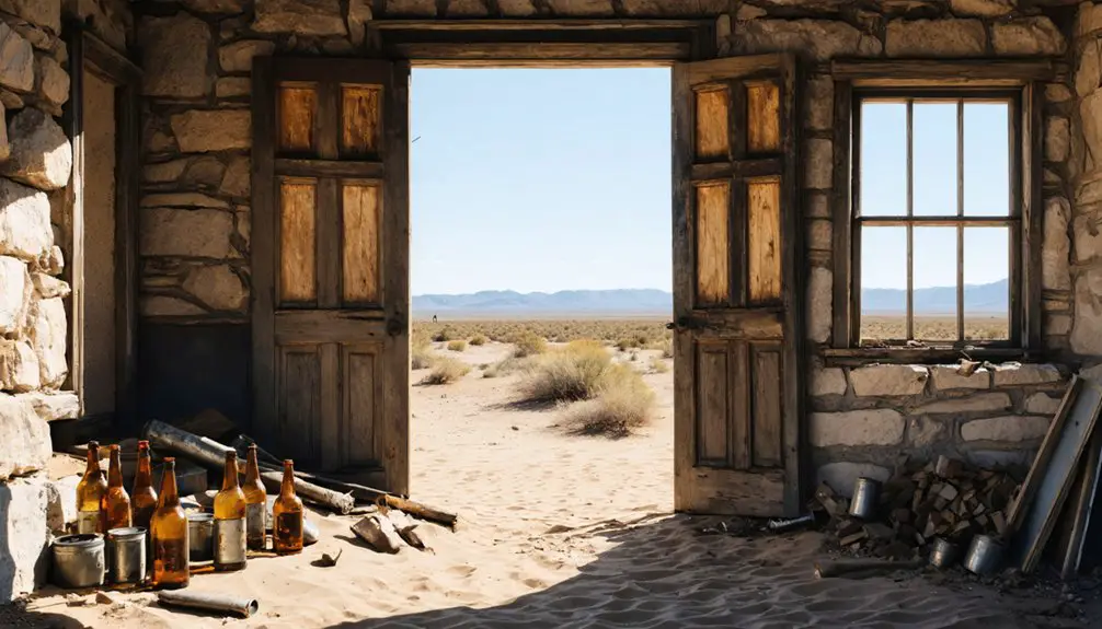
Notable Buildings and Infrastructure
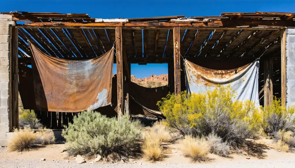
The skeletal remains of Sims, Utah tell a story through its surviving structures, with only five buildings standing out of the original thirty-plus that once formed this mining community.
Among these architectural styles, you’ll find the well-preserved adobe schoolhouse standing as the most historically significant building.
The town’s infrastructure remnants reveal a mix of construction methods, from cement walls to wood framing combined with stone or adobe.
You can still spot evidence of the town’s mining operations through ore loading areas with visible mule wagon tracks, while metal-lined storage spaces and stone-lined closets hint at specialized uses.
Desert vegetation now creeps over the foundations and building sites, slowly reclaiming what’s left of this once-bustling settlement.
Natural Disasters and Abandonment
Beyond the weathered buildings of Sims stood formidable environmental challenges that ultimately sealed its fate.
You’ll find that natural disasters and harsh climate conditions relentlessly tested the community’s resilience. The settlement struggled against severe water scarcity, making farming nearly impossible in the semi-arid landscape dotted with pine and juniper trees.
The town’s agricultural dreams crumbled under poor soil conditions and persistent crop failures. You’d have faced brutal winters, dust storms, and extreme temperature swings that battered homes and infrastructure.
These environmental pressures, combined with the high desert’s unforgiving terrain, made maintaining a viable community increasingly difficult. Like many Utah ghost towns, Sims couldn’t overcome the perfect storm of insufficient water, failed crops, and harsh weather, leading to its inevitable abandonment.
Preservation Efforts and Current State
Despite ongoing interest in Utah’s ghost towns, preservation efforts at Sims remain largely undocumented and informal.
You’ll find the site faces significant preservation challenges, including vandalism, illegal artifact removal, and structural deterioration from decades of abandonment.
While there’s no organized restoration project currently in place, you can look to successful models like the Grafton Heritage Partnership for potential solutions.
Community involvement could transform Sims through volunteer cleanup efforts, archaeological surveys, and educational programs.
You’ll need coordination between local historical societies, government agencies, and preservation groups to establish effective site management.
The remaining structures are likely fragile, with visible decay and natural reclamation taking hold.
Without proper intervention, you’re seeing the same risks that threaten many Utah ghost towns: collapsing buildings, fire hazards, and loss of historical integrity.
Historical Significance in Utah’s Mining Era
During Utah’s late 19th-century mining boom, Sims emerged as an essential extraction hub for gold, silver, and mercury deposits, establishing itself among the state’s network of resource-rich settlements.
You’ll find that Sims exemplified the region’s mining evolution, from basic prospecting to advanced mining techniques like the cyanide process. The town’s economic influence extended beyond mineral extraction, supporting a web of secondary businesses including smelters and supply stores.
The community dynamics reflected the era’s frontier spirit, with a diverse population of miners, families, and traders weathering the challenges of boom-and-bust cycles.
While Sims ultimately succumbed to depleted resources and structural mine failures, it remains a symbol of Utah’s pioneering mining heritage and the determination of early settlers.
Visiting the Ghost Town Today
While Sims stands as one of Utah’s more remote ghost towns, you’ll need careful planning and preparation to visit this historic mining site today. You won’t find marked roads or tourist facilities here – access requires maneuvering unmarked terrain, often with specialized vehicles.
For ghost town photography enthusiasts, early morning or late afternoon visits offer the best lighting conditions among the sparse ruins and desert landscape.
Hiking safety is paramount when exploring Sims. You’ll need to watch for unstable structures and abandoned mine shafts while traversing the rough terrain.
Plan your visit during spring or fall to avoid extreme temperatures, and bring plenty of water and emergency supplies. Since cell reception is unreliable, inform others of your plans before venturing to this isolated location.
Frequently Asked Questions
What Native American Tribes Originally Inhabited the Sims Area Before Settlement?
You’ll find that the Ute Tribe dominated this area as primary inhabitants, with some overlap into Shoshone Territory. The White River Ute band specifically controlled these eastern Utah lands.
Were Any Famous Outlaws or Gunfighters Known to Visit Sims?
Like dust in the desert wind, outlaw legends drift through Utah’s ghost towns, but you won’t find proof of famous gunfighter visits to Sims. No documented evidence supports claims of notable outlaws there.
What Happened to the Cemetery and Are There Marked Graves?
You’ll find sparse evidence of cemetery preservation efforts today, with most graves likely unmarked or lost to time. Any remaining grave marker significance is difficult to verify without detailed records.
Did Any Major Accidents or Deaths Occur in the Sims Mines?
You won’t find documented major accidents or deaths from Sims mines in historical records. While mine safety was a serious concern, nearby disasters like Scofield and Wilberg had detailed accident reports, but Sims didn’t.
Are There Any Documented Ghost Stories or Paranormal Activities in Sims?
You won’t find documented ghost sightings or paranormal investigations specific to Sims. While other Utah ghost towns like Grafton have extensive supernatural reports, there’s no verified paranormal activity recorded in Sims.
References
- https://www.ksl.com/article/51308628/restored-utah-ghost-towns-that-should-be-on-your-summer-travel-bucket-list
- https://www.youtube.com/watch?v=AoiIha-3iNo
- https://www.utahlifemag.com/blog/post/4-ghost-towns
- https://www.youtube.com/watch?v=eLGiwso6oZI
- https://capitolreefcountry.com/ghost-towns/
- https://historytogo.utah.gov/mining/
- https://www.uen.org/utah_history_encyclopedia/m/MINING.shtml
- https://utahrails.net/mining/brewster.php
- https://ugspub.nr.utah.gov/publications/uranium_data/MD00573_1.pdf
- https://utahmining.org/our-history/


