You’ll find Skagit City at 48.38333°N, 122.36306°W, established in 1868 as a bustling river port on the South Fork Skagit River. The town thrived with steamboat traffic, hotels, and John Barker’s trading post until the 1870s removal of river logjams shifted commerce to Mount Vernon. What began as an essential transportation hub with wharves, churches, and saloons now exists as scattered ruins, with only the restored Skagit City School marking its former glory.
Key Takeaways
- Skagit City, established in 1868, was once a thriving river trade settlement located at coordinates 48.38333°N and 122.36306°W.
- The town served as a vital steamboat transportation hub during the 1870s, connecting pioneers to Port Townsend and Seattle.
- Economic decline began after logjam removal redirected river traffic to Mount Vernon, coupled with the devastating Panic of 1893.
- The Great Northern Railway‘s bypass and shifting transportation patterns led to the town’s eventual abandonment and ghost town status.
- Today, only the restored Skagit City School and scattered archaeological remnants remain from the once-prosperous settlement.
Early Settlement and Geographic Location
While the fertile farmland of Fir Island drew white settlers in the 1860s, Skagit City‘s formal establishment in 1868 marked the beginning of a significant settlement on the northeastern tip of the island.
You’ll find this historic ghost town at coordinates 48.38333°N and 122.36306°W, nestled between the forks of the Skagit River and Skagit Bay.
Early settlement patterns centered around John Barker’s trading post, established in 1869, which quickly attracted more pioneers to the area.
The South Fork Skagit River provided the only navigable waterway in the area, as the North Fork led into marshlands.
A vital river ferry service connected residents to Mount Vernon and other nearby settlements.
Despite environmental challenges like frequent flooding, the community thrived initially, developing essential infrastructure including a wharf, churches, hotels, and saloons.
You can trace the town’s strategic location to a sandy bench area that served as a natural dock for paddlewheel riverboats, making it a crucial hub for river commerce and regional transportation.
River Trade and Commercial Growth
In the 1870s, you’d find Skagit City buzzing with scheduled steamboat traffic, as vessels like the Henry Bailey (209 tons) and W.F. Munro (100 tons) connected the settlement to Port Townsend and Seattle.
The town’s strategic position on the west bank of South Fork Skagit River made it a natural terminus for river commerce, especially while downstream logjams blocked access to points further upriver.
You could witness the bustling river wharf handling crucial cargo transfers of farm equipment, dry goods, and mail, which supported the growing network of pioneer settlers throughout the region. The town began its journey after John Barker established the first trading post in 1869.
Steamboat Routes and Services
Three primary steamboat routes connected Skagit City to the broader Puget Sound region during the 1870s, establishing essential supply lines for pioneer settlers.
You’d find regular service to Seattle and Port Townsend, with steamboats delivering mail, farm equipment, and dry goods critical for frontier life.
The 1872 construction of Skagit City’s wharf strengthened this steamboat commerce, despite challenging natural logjams that blocked continuous river navigation.
Commercial Hub Location Benefits
Skagit City’s strategic position at the south fork of the Skagit River established its dominance as a commercial powerhouse during the late 1800s.
You’ll find that its location on Fir Island created natural commercial advantages, as all river traffic had to pass through this critical junction before the clearing of upstream logjams.
The town’s strategic positioning below these natural barriers made it an important hub for loading goods and passengers.
You could’ve found a bustling community that grew from Barker’s Trading Post in 1869 into a thriving commercial center with hotels, stores, and important services.
The river wharf became essential for distributing agricultural products, supporting the valley’s farming operations, and facilitating trade in logging and coal from nearby areas.
The Battle Against Natural Obstacles
Throughout the late 1800s, the residents of Skagit City faced relentless natural challenges that threatened their community’s survival.
You’ll find their struggles against nature revealed through their determined efforts at logjam removal and flood mitigation, which shaped the town’s destiny.
Here’s what made their battle against nature so formidable:
- Massive logjams blocked river navigation for miles, requiring eight men to spend over two years cutting through.
- Frequent flooding on Fir Island repeatedly destroyed schoolhouses and public buildings.
- The town’s location on a triangular piece of land between river forks limited access and escape routes.
- Shifting river channels constantly altered navigation paths, complicating trade and transport.
Despite their persistence in clearing obstacles, these environmental challenges ultimately contributed to Skagit City’s decline, especially as nearby Mount Vernon gained prominence.
Riverbank erosion gradually destroyed critical infrastructure, accelerating the town’s eventual abandonment.
Daily Life and Social Structure
If you’d visited Skagit City in its prime, you would’ve found social life centered around key gathering spots like churches, saloons, and community halls where residents connected through fraternal organizations and cultural events.
The local post office, established in 1872, served not just for mail but as a crucial hub where townspeople exchanged news and maintained connections with the outside world.
The various schoolhouses, particularly the 1902 building on Moore Road, functioned as both educational facilities and venues for community gatherings, reinforcing the town’s social bonds despite the challenges of frequent flooding.
Community Gathering Places
During its peak years in the 1870s, the social fabric of Skagit City centered around several key gathering places that defined daily life.
You’d find a vibrant mix of commercial and social spaces where community events and cultural activities flourished, creating bonds among settlers and travelers alike.
- John Barker’s trading post served as the town’s primary meeting point, where you could exchange news and goods.
- Hotels and saloons dotted the waterfront, offering spaces for socializing after work.
- Churches provided spiritual guidance and hosted regular gatherings for worship.
- The post office, established in 1872, became a hub for civic interaction and communication.
The riverfront bustled with activity as steamboats brought visitors, while the wharf became a natural gathering spot where you’d catch up with neighbors and conduct business.
Social Groups and Organizations
Building upon the town’s active gathering spaces, Skagit City’s social structure was shaped by a rich network of fraternal organizations and civic groups that brought settlers together in meaningful ways.
These membership-based lodges fostered community bonds while providing essential social support during the town’s economic ups and downs.
You’d find a vibrant mix of cultural activities centered around the post office, churches, and schools. The 1872 post office connected you to the outside world, while local churches and schools reinforced shared values.
Workers from riverboats, logging camps, and Barker’s Trading Post formed tight-knit occupational communities.
Despite flooding challenges, the community showed resilience by rebuilding structures like the 1902 schoolhouse.
When residents later moved to Mount Vernon and Fir Island, these social ties helped preserve the town’s identity even as its physical presence faded.
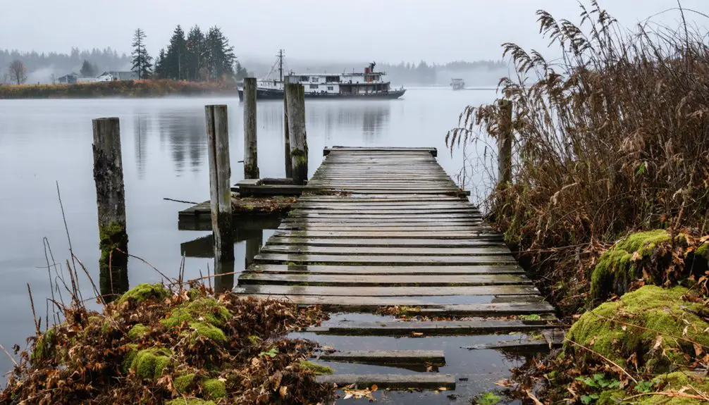
Transportation Hub and Maritime Connections

Situated at a critical juncture of the Skagit River, Skagit City emerged as an essential transportation hub before Mount Vernon’s ascendance.
During its heyday, you’d find bustling maritime connections that shaped the region’s transportation evolution. Before roads and railways dominated, riverboats were your lifeline for moving freight and passengers through the area. The arrival of the Bellingham and Skagit interurban railway in 1912 marked a significant shift in regional transportation options. Today, the region’s public transit needs are served by Skagit Transit, established in 1993.
Key aspects of Skagit City’s maritime significance:
- Two major logjams spanning 2 miles initially restricted upstream navigation
- The removal of these logjams in the 1870s redirected river traffic to Mount Vernon
- Steamboats provided vital freight and passenger service along the Skagit River
- River access determined early settlement patterns and commercial development
The city’s decline directly linked to improved river navigation upstream, which shifted economic activity toward Mount Vernon’s growing influence.
Economic Decline and Relocation
The removal of two massive logjams from the Skagit River in the 1870s marked the beginning of Skagit City’s economic downfall. Once these two-mile-long obstacles were cleared by the U.S. Army Corps of Engineers, river traffic bypassed the settlement in favor of upstream destinations, particularly Mount Vernon.
You’ll find that this economic shift triggered a cascade of consequences. The town’s population began moving away as businesses relocated to more strategically positioned communities.
Skagit City’s heavy reliance on natural resource industries, including logging and fishing, made it especially vulnerable to market fluctuations. When national economic crises hit, including the Panic of 1893, the town’s fragile economy couldn’t withstand the pressure. Like thousands of other settlements across Washington, the town suffered from widespread bank failures that devastated local businesses and residents.
The combination of reduced river traffic, industry changes, and broader economic shocks ultimately led to the town’s abandonment.
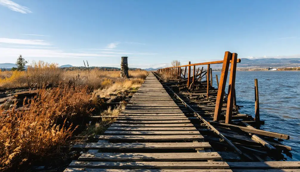
Surviving Landmarks and Physical Traces
While modern visitors to Skagit City won’t find many standing structures from its heyday, several significant physical traces remain at this historic ghost town site. The town’s decline accelerated when the Great Northern Railway bypassed it.
Similar to foundations at Franklin, scattered building remains dot the landscape, providing glimpses into the town’s past development.
Located on the western bank of the South Fork Skagit River, landmark preservation efforts have focused primarily on the restored Skagit City School, which stands as a cultural heritage center.
Archaeological significance can be found in:
- Barker’s Trading Post foundations, marking the town’s original settlement area
- Remnants of river port infrastructure along the historic waterfront
- Scattered artifacts from the late 1800s, including metal fragments and brick rubble
- Union hall and post office locations, identified through archaeological traces
Natural forces continue to shape the site, with vegetation covering many ruins and seasonal flooding depositing alluvial layers that both preserve and conceal the town’s physical history.
Historical Impact on Skagit County
Beyond its physical remnants, Skagit City‘s influence shaped the economic and social development of Skagit County throughout the late 1800s.
You’ll find its cultural significance woven into the region’s historical narratives, from its role as an early commerce hub to its lasting impact on settlement patterns.
As the first major trading center on Fir Island, Skagit City established vital transportation networks that connected settlers to Puget Sound markets.
The town’s hotels, stores, and social organizations created a vibrant community hub that laid the groundwork for future development.
While Mount Vernon’s rise led to Skagit City’s decline, the town’s legacy lives on in the county’s evolution.
Its story exemplifies how changes in transportation and commerce can dramatically reshape regional development patterns.
Frequently Asked Questions
What Indigenous Tribes Originally Inhabited the Area Before Skagit City’s Founding?
You’ll find the Upper Skagit Indian Tribe’s Indigenous history dominated the area, alongside other Coast Salish peoples including the Samish, Sauk-Suiattle, Swinomish, and Stillaguamish, each maintaining distinct tribal cultures.
How Did the Great Depression Affect the Final Years of Skagit City?
While neighbors gathered in soup lines, you’d see Skagit City’s last shops shuttering and families departing. The Depression’s economic decline accelerated the town’s emptying, leaving only abandoned buildings by the late 1930s.
Were There Any Notable Crimes or Lawlessness During Skagit City’s Peak Years?
You won’t find evidence of notable crimes or significant lawlessness. Historical records show no major incidents, suggesting low crime rates despite limited law enforcement in this closely-knit frontier community.
What Happened to the Cemetery and Burial Grounds of Skagit City?
You’ll find little remains of the cemetery today – it’s largely unmarked and overgrown. The burial grounds faced natural decay, vegetation reclamation, and neglect after the town’s population declined and moved away.
Did Any Famous Historical Figures Ever Visit or Stay in Skagit City?
You won’t find any famous visitors of national significance in Skagit City’s historical records. The town primarily drew local pioneers and river traders, with John Barker’s trading post being its main historical landmark.
References
- https://en.wikipedia.org/wiki/Skagit_City
- https://powerlines.seattle.gov/2019/10/15/haunted-concrete-exploring-the-communitys-creepy-past/
- https://skagittalk.com/2021/03/11/skagit-city-the-town-a-log-jam-built/
- https://northwestprimetime.com/news/2022/apr/12/lost-cities-skagit/
- https://meyersign.com/2022/07/tales-of-the-magic-skagit-once-upon-a-time-in-skagit-city/
- https://www.randomconnections.com/searching-for-skagit-city/
- https://www.skagitriverhistory.com/PDFs/History of Skagit River.pdf
- https://en.wikipedia.org/wiki/Skagit_River
- https://www.historylink.org/File/21283
- https://www.historylink.org/File/10904