You’ll find Somerfield’s haunting remains beneath Pennsylvania’s Youghiogheny River Lake, where this once-bustling National Road town thrived from 1817 to 1941. Founded at the intersection of the National Road and Youghiogheny River, the town featured the iconic Great Crossings Bridge until the U.S. Army Corps of Engineers submerged it in the 1940s. During droughts, the town’s stone foundations, brick walkways, and resilient bridge emerge from the depths, revealing untold stories of American frontier life.
Key Takeaways
- Somerfield was a thriving town along Pennsylvania’s National Road until it was submerged underwater by the creation of Youghiogheny River Lake in 1940.
- The town’s remains, including building foundations and the historic Great Crossings Bridge, become visible during drought conditions and controlled water releases.
- Before submergence, Somerfield served as an important stop along the National Road, featuring taverns and accommodations for travelers in the 1800s.
- The U.S. Army Corps of Engineers flooded the town in the 1940s, forcing residents to abandon their homes and businesses.
- Original sidewalks, road curbs, and the 1818 stone bridge remain preserved underwater, creating an archaeological site explored during low-water periods.
The Birth of a Historic River Town
While Native American tribes like the Shawnee and Delaware inhabited the area as early as 1740, Somerfield’s European foundations began in 1769 when Jacob Spears first warranted the land along the Youghiogheny River.
In 1816, local tavern keeper Philip D. Smyth purchased the property from Spears and established Smyth’s Tavern, recognizing the strategic value of this crossroads location. The area had long served as Great Crossings, a significant fording point across the river. The town was officially laid out in 1818 as Smythfield by its founder.
You’ll find Somerfield’s origins deeply rooted in its placement at the intersection of the National Road and Youghiogheny River.
Life Along the National Road
As travelers journeyed westward on America’s first federally funded highway, Somerfield emerged as a vital waypoint along the National Road in the early 1800s.
Somerfield stands as testament to America’s westward expansion, a crucial stop where pioneers found rest along the National Road.
George Washington had crossed the same river nearly 70 years earlier during his expedition in 1753.
The traveling community transformed this riverside settlement into a bustling hub of commerce and hospitality. The road’s construction and maintenance received federal funding support until 1839, when responsibilities shifted to individual states.
You’d have found these essential elements of Somerfield’s economic transformation:
- The Great Crossings Bridge, a masterful 375-foot sandstone structure dedicated by President Monroe in 1818, connecting travelers across the Youghiogheny River.
- Kinkead’s stone tavern and Endsley’s establishment, where you could rest alongside other wayfarers while fresh horses were prepared for your journey.
- Relay stations positioned every 10-12 miles, ensuring your continuous progress westward while supporting local businesses and creating jobs for the townspeople.
The Great Crossings Bridge Legacy
Three remarkable individuals – James Kinkead, James Beck, and Evan Evans – constructed the Great Crossings Bridge between 1813 and 1818, creating one of America’s most significant early infrastructure projects.
The bridge’s architecture showcased masterful stonework: three massive arches spanning 375 feet across the Youghiogheny River, standing 40 feet high and 30 feet wide.
You can appreciate its historical significance through President James Monroe’s attendance at the July 4, 1818 dedication ceremony.
The bridge’s construction led to the establishment of the small town of Somerfield in 1817, which flourished from National Road traffic.
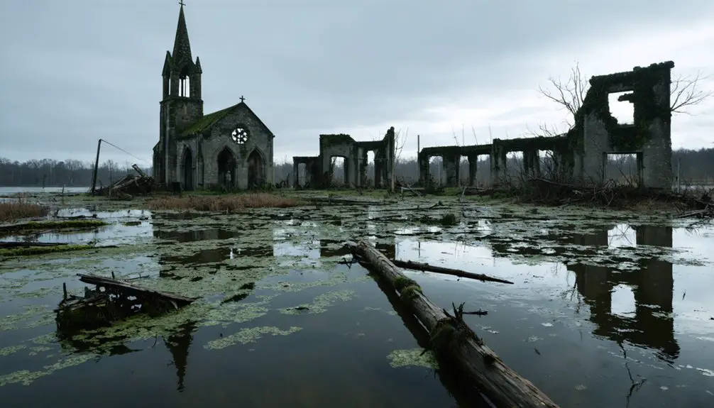
While the bridge now rests beneath Youghiogheny River Lake’s waters, it emerges during droughts to remind you of its glory days.
When visible, it draws thousands of visitors enthusiastic to witness this preserved piece of America’s westward expansion, though you’ll need to admire it from a safe distance due to structural concerns.
The structure became permanently submerged in 1940 when the lake was created for flood control and power generation.
When the Waters Came
In 1941, you’d have witnessed the gradual end of Somerfield, Pennsylvania, as the Daily American newspaper declared the town “doomed” while the Youghiogheny River waters began their slow rise.
Today, during severe drought conditions, you can see the Great Crossings Bridge reemerge from beneath fifty feet of water, drawing thousands of curious visitors to this historic landmark.
During summer months, heritage enthusiasts gather to document and explore the historic ruins that offer a glimpse into the past.
By 1944, you could watch the Army Corps of Engineers’ deliberate flooding transform this once-bustling National Road community into a ghost town, forcing residents to abandon homes and businesses that had stood since 1816.
The waters of what would become Yough Lake swallowed sidewalks, streets, and the historic 1818 stone bridge, leaving only memories and submerged remnants that occasionally resurface during droughts.
A Community’s Final Days
While World War II temporarily delayed the dam’s construction, Somerfield’s systematic demolition and flooding began in the early 1940s, culminating in the town’s complete submersion beneath Yough Lake by 1944.
Community memories and emotional ties to this once-thriving town were deeply shaken as residents watched their homes disappear beneath the rising waters. President James Monroe attended the original bridge dedication ceremony in 1818, marking a significant moment in the town’s history. The relocation affected 176 local residents who were forced to leave their homes and community behind.
You can imagine the heartbreaking scenes as:
- Families packed their belongings and left their generational homes, with one elderly woman reportedly dying shortly before the forced relocation.
- The Army Corps of Engineers methodically demolished structures throughout the valley.
- A lone house stood as the last relic of Somerfield’s existence before the waters claimed it.
The flooding erased not just buildings, but also the social fabric that had defined this tight-knit Pennsylvania community for generations.
Rising Lake, Vanishing Town
The flooding of Somerfield began as a methodical process orchestrated by the U.S. Army Corps of Engineers in the early 1940s.
You’d have witnessed crews demolishing homes and clearing trees, leaving only foundations and stone remains as silent witnesses to what would unfold. The lake’s impact forever changed the landscape as waters gradually rose, reaching depths of 90 feet above the town by 1944.
Where you once could’ve walked down bustling streets past a hotel and homes of 150 residents, the Youghiogheny River Lake now conceals these town memories beneath its surface.
The waters submerged not just Somerfield, but also nearby communities like Thomasdale, Jockey Hollow, and Watsondale, transforming an entire valley into a vast reservoir that would help control flooding in Pittsburgh’s region.
Hidden Beneath Youghiogheny Lake
Beneath approximately 90 feet of Youghiogheny Lake’s waters lies Somerfield, Pennsylvania, a once-thriving community established between 1816 and 1818 along the National Road.
Deep beneath Youghiogheny Lake rests Somerfield, a historic Pennsylvania town swallowed by progress in the early 19th century.
This submerged history creates an underwater archaeology site that you can explore during rare low-water conditions.
When the lake’s waters recede, you’ll discover:
- The Great Crossings Bridge from 1818, showing remarkable resilience despite eight decades underwater
- Original sidewalks and road curbs that once lined the streets of this 150-resident town
- Building foundations and scattered brick debris fields marking where homes and businesses stood
These remnants tell the story of a vibrant Pennsylvania town that flourished until the 1940s, when the Army Corps of Engineers’ dam project transformed the valley into today’s lake, leaving Somerfield’s legacy preserved in its watery tomb.
Resurfacing From the Depths
During rare periods of drought and controlled water releases, Somerfield’s ghostly remains emerge from Youghiogheny Lake’s depths, drawing hundreds of thousands of curious onlookers to southwestern Pennsylvania.
You’ll discover archaeological findings scattered across the exposed lakebed, including stone foundations, brick walkways, and the iconic Great Crossings Bridge that once carried travelers along the National Road.
These submerged structures tell a compelling story of American frontier life, revealing the town’s 19th-century layout and construction methods.
When oxygen hits the exposed ruins, it accelerates their decay, while shifting sediments temporarily disclose the original valley topography.
Local ecosystems quickly adapt as plants recolonize the newly exposed ground, creating a fascinating intersection of history and nature that you can explore during these fleeting periods of resurfacing.
Modern-Day Exploration and Discovery

While Youghiogheny River Lake’s waters occasionally recede, modern-day explorers flock to southwestern Pennsylvania’s most intriguing archaeological site, where you’ll find remnants of Somerfield’s past scattered across the exposed lakebed.
Urban exploration enthusiasts and historical preservation advocates document the site through videos, photos, and drone footage, creating valuable records of this vanishing piece of America.
When conditions allow, you can explore:
- Original roadways and stone walkways that once guided residents through their bustling town
- The iconic Great Crossings Bridge, a symbol of the National Road’s historical significance
- Building foundations and scattered artifacts that tell stories of 19th and 20th-century small-town life
Safety measures like floating devices help protect visitors as they navigate this temporary window into Pennsylvania’s submerged history.
Frequently Asked Questions
Were Any Artifacts Recovered From Homes Before the Flooding Began?
You won’t find evidence of systematic artifact preservation before flooding. While residents took personal belongings, there’s no record of official recovery efforts preserving items of historical significance from Somerfield’s homes.
Did Any Residents Refuse to Leave During the Evacuation?
You won’t find any confirmed evacuation stories or resident memories of people refusing to leave Somerfield – historical records show all 150 residents complied with the mandatory relocation before the waters rose.
Are There Any Known Deaths Associated With Exploring the Submerged Ruins?
While ghostly encounters draw urban explorers to these watery ruins, you’ll find no documented deaths from exploring the submerged town, though officials warn about structural hazards and cold water risks.
What Happened to the Cemetery When the Town Was Flooded?
You’ll find limited documentation about the cemetery’s relocation during the flood aftermath. While some bodies may have been moved, local stories suggest many graves remain submerged beneath Youghiogheny River Lake’s waters.
Do Any Original Somerfield Residents or Their Descendants Still Live Nearby?
Time has scattered the seeds of Somerfield families far and wide. While historical records don’t confirm current residents’ exact locations, you’ll find some descendants still living in the broader southwestern Pennsylvania region.
References
- https://www.youtube.com/watch?v=ujCWM9PefHI
- https://www.observer-reporter.com/news/local-news/2024/nov/17/reemergence-of-206-year-old-great-crossings-bridge-draws-thousands-to-yough-lake/
- http://swpare.blogspot.com/2011/01/youghiogheny-dam-and-forgotten-town-of.html
- https://en.wikipedia.org/wiki/List_of_ghost_towns_in_Pennsylvania
- https://www.youtube.com/watch?v=qCzDNVmZO5s
- https://www.pa-roots.com/2015/03/28/somerfield-somerset-county/
- http://www.mountaindiscoveries.com/images/ss2020/stories/Yough Towns.pdf
- https://pagenweb.org/~somerset/addison/somerfield_town.htm
- http://www.kathrynbashaar.com/2021/01/the-national-road-part-one/
- https://en.wikipedia.org/wiki/National_Road


