You’ll find St. Deroin’s ghost town remains within Indian Cave State Park along the Missouri River. Founded in 1853 by Joseph Deroin, a mixed-heritage trader of French-Canadian and Otoe descent, this settlement grew to 200 residents with 20 businesses by the 1870s. Though flooding and railroad bypasses led to its abandonment by 1920, you can still explore the restored schoolhouse, cemetery, and rebuilt general store that tell the story of Nebraska’s diverse cultural heritage.
Key Takeaways
- Founded in 1853 by Joseph Deroin, St. Deroin was a Missouri River trading post that grew into a thriving town of 200 residents.
- Located in present-day Indian Cave State Park, St. Deroin served as a cultural crossroads between Native American and European settlers.
- Repeated flooding and the railroad’s bypass led to the town’s decline, becoming completely abandoned by 1920.
- Only the relocated schoolhouse and cemetery remain as physical structures, while stone foundations mark former building locations.
- The ghost town site is accessible through Indian Cave State Park’s hiking trails and features a reconstructed general store.
The Birth of a Mixed-Heritage Settlement
While many frontier settlements emerged from military outposts or railroad junctions, St. Deroin began as a unique representation of America’s complex heritage identity.
In 1853, Joseph Deroin, a mixed-heritage trader of Métis French Canadian and Otoe descent, established the settlement on land granted through the 1830 Treaty of Prairie du Chien.
You’ll find the roots of cultural integration deeply embedded in St. Deroin’s founding. The town grew from Deroin’s trading post near the Missouri River, where he’d been operating since the 1840s.
Together with Robert Hawke, he platted the village on a 320-acre grant, strategically naming it “St. Deroin” to align with established river cities like St. Joseph and St. Louis. The settlement thrived with a diverse population that included various Native American tribes.
This thoughtful naming convention aimed to attract settlers to this newly formed mixed-heritage community.
Life Along the Missouri River
The Missouri River shaped every aspect of life in St. Deroin, where you’d find a bustling community built upon the dynamic relationship between people and river ecology.
You could witness settlers and Native Americans alike taking advantage of the rich floodplain soil for farming, while hunters tracked buffalo and other game along the river’s corridor. The Omaha and Oto tribes had long established their presence in the region before settlers arrived.
The settlement dynamics reflected careful planning, with buildings positioned on higher ground to avoid seasonal floods. The river’s annual twice yearly floods brought both risk and renewal to the community.
Early settlers demonstrated remarkable foresight, strategically placing their buildings above flood-prone areas to ensure the settlement’s longevity.
You’d see a grid layout designed to move goods efficiently from riverboat landings inland. Daily life revolved around the river’s rhythms – from the arrival of steamboats bringing supplies and news to the operation of ferries connecting communities.
The surrounding riparian areas provided herbs, plants, and timber, while sawmills and flour mills harnessed the river’s resources for local industry.
Trading Post and Ferry Operations
You’ll find that Missouri River commerce defined St. Deroin’s early development, with Joseph Deroin’s trading post serving as an essential hub for both Native American and settler trade starting around 1840.
Local historians note that ancient petroglyphs discovered nearby indicate the area’s rich Native American heritage long before the trading post was established.
The addition of ferry service in 1854 transformed St. Deroin into a significant river crossing point, connecting Iowa settlements to Nebraska Territory and facilitating regional commerce.
The trading post and ferry operations helped the town reach its peak of nearly 200 residents by the 1870s, supporting about 20 businesses before changes in river navigation and transportation methods led to its decline.
Missouri River Commerce
During the early 1800s, Missouri River commerce flourished through a network of strategically placed trading posts that served as crucial economic hubs along Nebraska’s eastern border.
You’d find bustling riverboat trade at posts like Fontenelle’s and Cabanné’s, where trappers and Native Americans exchanged thousands of pelts annually. In 1827 alone, Cabanné’s post handled over 2,800 beaver pelts and 4,000 bison robes. Prince Maximilian of Wied visited the trading post in 1823 aboard the steamboat Yellowstone.
The river’s powerful current carried massive shipments downstream to St. Louis via mackinaw boats, keelboats, and later, steamboats. Spanish authorities patrolled these waters with armed galiots to protect their trading interests.
Trading posts strategically positioned near river junctions maximized access for tribes like the Omaha, Otoe, and Pawnee. These commercial centers weren’t just about the pelts exchange – they became crucial points of cultural interaction between Native Americans and European traders, shaping the region’s economic landscape.
Ferry Crossing Economic Impact
Founded by Joseph Deroin, a mixed-heritage entrepreneur born to a French trapper and Otoe woman, St. Deroin’s economic significance centered around its trading post and ferry crossing.
You’ll find that these operations formed the backbone of local commerce for over three decades, connecting Nebraska markets with Missouri’s opportunities across the river.
The ferry economics proved essential to the town’s growth, as traders, settlers, and merchants relied on this river transportation link to move goods and people.
The trading post served 230 mixed-heritage residents while attracting additional businesses like blacksmiths and lodging services.
The devastating flood of 1911 completely destroyed the town, ending its economic viability as a trading and transportation hub.
However, when the Missouri River changed course in the early 20th century, you’d have seen the town’s decline accelerate.
The ferry landing was left unusable, severing crucial trade connections and ultimately contributing to St. Deroin’s transformation into a ghost town.
Natural Disasters and Economic Challenges
Natural disasters and economic setbacks dealt devastating blows to St. Deroin, leading to its eventual abandonment.
You’ll find that the Missouri River’s repeated flooding destroyed much of the town’s infrastructure, forcing residents to relocate essential buildings like the school to higher ground on the bluffs. The river’s course changes proved particularly devastating, cutting off the town’s crucial ferry service that had sustained the local economy for over three decades.
These natural disasters coincided with significant economic decline as the railroad bypassed the settlement, redirecting commerce and travelers elsewhere. Today, the area is part of Indian Cave Park, spanning over 3,000 acres.
Without its ferry crossing and excluded from rail transport, you can see how St. Deroin’s isolation deepened. The combined impact of flooding and lost transportation links made business unsustainable, ultimately transforming this once-thriving river town into a ghost town by 1920.
Cultural Legacy and Native American Connections
Rich in cultural complexity, St. Deroin stands as a symbol of the blending of Native American and European cultures along the Missouri River.
You’ll find the town’s legacy deeply rooted in the Nemaha Half-Breed Reservation, established in 1830 for mixed-heritage individuals who faced exclusion from both tribal and settler societies.
The town’s namesake, Joseph Deroin, embodied this cultural intersection. As the son of a French-Canadian Métis trader and an Otoe woman, he established a trading post that became essential to cultural preservation in the region.
Today, you can explore the area’s indigenous heritage through ancient petroglyphs at Indian Cave State Park, where sandstone caverns reveal thousands of years of Native American presence. The area was originally inhabited by nine distinct tribes, including the Otoe, Missouri, Omaha, Pawnee, Lakota, Kansas, Ponca, Cheyenne, and Arapaho.
These artifacts and sites continue to tell the story of the complex relationships between Native, mixed-heritage, and European-American communities.
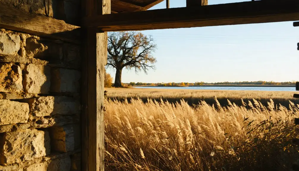
Exploring the Ghost Town Today
You’ll find St. Deroin’s remains within Indian Cave State Park’s northern boundary, where over 22 miles of hiking trails lead you through the historic site.
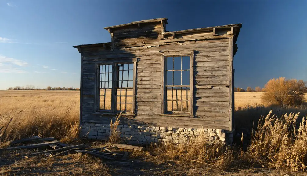
The schoolhouse stands as the most prominent surviving structure, perched atop the river bluff where it’s weathered decades of environmental challenges. During peak years, the town flourished with twenty local businesses.
The town cemetery rests on elevated ground near the school, while ground depressions throughout the site mark where other buildings once stood in this Missouri River trading community.
Park Access Points
Located within Indian Cave State Park’s northern boundary, St. Deroin’s remains are accessible through multiple entry points that connect to local roads northeast of Barada, Nebraska.
You’ll find 22 miles of hiking and biking trails leading to the ghost town, though some routes traverse steep terrain and deep-cut hillsides.
For trail accessibility, you can start your exploration from either Ash Grove or Hackberry Hollow campgrounds, where parking facilities accommodate both day visitors and overnight campers.
Gravel roads lead to dedicated parking areas near the ghost town ruins and schoolhouse, though high-clearance vehicles are recommended during wet seasons.
You’ll also discover river access points nearby, offering scenic overlooks of the Missouri River and the historic ferry crossing site.
Remaining Historical Structures
After making your way through Indian Cave State Park’s trails, the remaining structures of St. Deroin reveal themselves as evidence of historical preservation.
You’ll find the relocated St. Deroin School building, carefully moved brick by brick to higher ground, standing as one of the few intact structures. The cemetery, perched safely on the river bluffs, contains graves of the town’s founders and mixed-heritage residents, offering archaeological significance to researchers and visitors alike.
You’ll spot scattered stone foundations marking former homes and businesses, now weathered and vegetation-covered after a century of abandonment. A rebuilt general store overlooking the Missouri River serves as an interpretive site, representing the town’s once-bustling trading post founded by Joseph Deroin.
Frequently Asked Questions
Are There Any Reported Ghost Sightings in the Abandoned Town of St. Deroin?
Among 300,000 annual visitors, you’ll find frequent reports of ghostly encounters at the cemetery and former townsite, where A.J. Ritter’s one-armed spirit and other apparitions make these haunted locations particularly active.
What Was the Average Property Value in St. Deroin During Its Peak?
You won’t find exact property market values from the 1870s peak period, as historical appraisal records weren’t preserved. While homes and businesses existed, flooding risks likely kept values relatively modest.
Did Any Famous Historical Figures Ever Visit or Pass Through St. Deroin?
You’ll find Lewis and Clark camped near the future site of St. Deroin in 1804, but no famous visitors documented after the town’s 1854 founding. The location’s historical significance stems from local pioneers.
What Happened to the Descendants of St. Deroin’s Original Settlers?
You’ll find descendant stories scattered across Nebraska and beyond, as families dispersed after 1920’s flooding. Their family legacies live on through mixed Native American and French heritage connections.
Were There Any Churches or Religious Institutions Established in St. Deroin?
You won’t find records of formal church history or religious architecture in the settlement. While the cemetery indicates spiritual practices existed, evidence suggests worship likely occurred in informal community or household settings.
References
- https://www.nebraskalife.com/blog/post/saint-deroin-ghost-town
- https://en.wikipedia.org/wiki/St._Deroin
- https://www.nebraskalife.com/printpage/post/index/id/95
- https://kids.kiddle.co/St._Deroin
- https://www.oocities.org/raydrouin@rogers.com/stderoin.htm
- https://www.forttours.com/pages/indiancave.asp
- https://trailmeister.com/wp-content/uploads/maps/indiancave.pdf
- https://www.metismuseum.ca/media/document.php/14427.Joseph DeRoin.pdf
- https://theplanninglady.com/2020/07/12/history-of-indian-cave-state-park/
- https://history.nebraska.gov/wp-content/uploads/2017/12/doc_publications_NH1961MissouriRFrontier.pdf


