You’ll find St. Thomas, Nevada beneath Lake Mead’s waters – a Mormon settlement founded in 1865 that once thrived along the Muddy River. The town grew to 500 residents with sophisticated irrigation systems, schools, and stores until Hoover Dam’s construction forced its abandonment in 1938. Today, dropping water levels periodically reveal the town’s concrete foundations, stone walls, and cisterns, offering glimpses into pioneer life and water management’s lasting impact on the American West.
Key Takeaways
- St. Thomas was a thriving Mormon settlement founded in 1865 along the Muddy River, serving as a crucial freight stop between Utah and California.
- The town peaked at 500 residents with farms, stores, and irrigation systems before territorial disputes forced most settlers to leave in 1871.
- Hoover Dam’s construction in 1928 led to St. Thomas’s complete submergence under Lake Mead’s waters by June 1938.
- The ghost town periodically resurfaces during Lake Mead’s low water levels, revealing building foundations and other historical remnants.
- The National Park Service maintains the site, with marked trails and interpretive signs telling the story of this submerged frontier settlement.
From Mormon Settlement to Modern Ruins
When Mormon leader Thomas Smith established St. Thomas in 1865, you’d find the settlement strategically positioned along the Muddy River, serving as an essential freight route between Salt Lake City and the Colorado River.
St. Thomas emerged in 1865 as a vital Mormon outpost, linking Salt Lake City to the Colorado River through the Muddy River valley.
The settlers’ Mormon heritage shaped their industrious approach, quickly developing sophisticated irrigation systems by 1866 that transformed the arid valley into productive farmland. Today, these ruins become visible when Lake Mead recedes.
You’ll discover how the town’s early prosperity attracted 45 families who built their lives around communal cisterns and concrete-lined canals. Their agricultural success with cotton, grains, and fruit trees demonstrated the settlers’ resourcefulness. The town’s population continued to grow, reaching nearly 500 residents during its peak years.
Yet by 1871, a territorial boundary dispute revealed St. Thomas was actually in Nevada, not Utah. When faced with hefty back taxes, all but the Bonelli family abandoned the settlement, marking a pivotal moment in the town’s trajectory.
The Rise and Fall of a Desert Oasis
Despite its humble beginnings, St. Thomas thrived as a desert oasis at the confluence of the Virgin and Muddy Rivers, where fertile lands supported farming communities and Bonelli’s ferry service connected travelers across the Colorado River.
You’ll find this submerged history particularly fascinating, as the town transformed from a Mormon settlement into a vibrant community before its dramatic end. The town was established by Mormon pioneers in 1865 who initially thought they were settling in Utah territory.
Three key phases marked the town’s evolution:
- Agricultural prosperity with fertile riverside farmland
- Economic diversification through transportation and commerce
- Final decline as Lake Mead’s waters rose
The abandoned relics you can spot during low water levels tell a compelling story of displacement, as residents like Hugh Lord were forced to evacuate their homes. The Lost City complex nearby contained ancient Native American settlements that were also submerged by the rising waters.
When Lake Mead reached full pool, the town vanished beneath 50 to 80 feet of water, marking the end of this remarkable desert community.
Life Along the Muddy River
Along the banks of the Muddy River, Mormon settlers established a vibrant agricultural community in 1865, transforming the harsh desert landscape into productive farmland through strategic irrigation systems.
The settlers initially paid Utah taxes until an 1870 survey revealed they were actually located in Nevada.
You’d find cottonwood trees lining the streets, offering respite from the desert sun while marking the settlers’ determination to create a livable environment.
The community’s agricultural resilience emerged through their adaptations to the Muddy River’s temperamental nature. Despite floods and droughts threatening their existence, settlers developed robust farming practices that sustained up to 500 residents.
They built irrigation networks that supported crops while managing without modern amenities like electricity and running water. The river, fed by natural springs, became their lifeline – providing essential resources for farming, drinking, and trade along the Los Angeles to Salt Lake City route. The town thrived until the Hoover Dam construction forced residents to abandon their homes in the 1930s.
When Lake Mead Swallowed a Town
The construction of Hoover Dam in 1928 marked the beginning of St. Thomas’s transformation into a submerged ghost town.
In 1928, Hoover Dam’s construction set in motion the slow drowning of St. Thomas beneath Lake Mead’s rising waters.
As Lake Mead began filling in 1935, residents faced the inevitable loss of their homes, with the government offering minimal compensation through eminent domain.
The town flourished as a key stop along the Arrowhead Trail route connecting major western cities.
Post office operations continued until June 19, 1938, processing over 5000 final letters.
You can trace the town’s final days through these pivotal moments:
- Residents dismantled their homes or abandoned their properties between 1932-1938.
- Hugh Lord, the last inhabitant, burned his house and rowed away as waters reached his doorstep.
- By June 25, 1938, Lake Mead completely swallowed St. Thomas, burying it 60-80 feet underwater.
Today, drought has exposed this piece of submerged history, revealing foundations, roads, and the iconic ice cream parlor chimney.
You’ll find these remnants telling stories of sacrifice for progress within Lake Mead National Recreation Area.
Pioneer Stories and Daily Life
When Mormon pioneers first established St. Thomas in 1865, they’d envisioned building a thriving agricultural community near the Virgin and Muddy Rivers.
Pioneer experiences centered around farming, with about 45 families cultivating cotton, grain, and fruit trees by 1866. You would’ve found their daily routines revolving around the concrete-lined irrigation canals and communal cisterns, where residents gathered water and socialized.
The town grew to support 500 residents at its peak, offering amenities like schools, stores, and an ice cream parlor. Salt mining provided an important industry for the growing community.
Despite lacking modern conveniences like electricity or indoor plumbing, you’d have witnessed a self-sufficient community spirit. Life maintained a peaceful rhythm until the 1930s, marked by shared activities at community buildings and the essential railroad connection established in 1911.
Ancient Footprints: Native American Heritage
Long before Mormon pioneers established St. Thomas, ancient peoples carved out a remarkable legacy in the Muddy River Valley.
Archaeological evidence reveals human presence dating back to 8000 B.C.E., showcasing one of the Southwest’s longest records of cultural continuity.
The most significant settlement, Pueblo Grande de Nevada (Lost City), thrived through ancient agriculture and adaptation to desert conditions. The area’s rich history took a dramatic turn when the Hoover Dam construction forever altered the landscape.
You’ll discover how successive cultures mastered this challenging landscape:
- Basketmaker peoples (300 A.D.) built innovative pit houses for temperature control
- Ancestral Puebloans (830-1150 A.D.) expanded settlements and agricultural practices
- Multiple groups cultivated corn, beans, squash, and cotton along the fertile riverbanks
These rich archaeological sites now rest beneath Lake Mead’s waters, but their artifacts and structures preserved at Lost City Museum tell an enduring story of indigenous ingenuity and resilience.
Trading Post on the Arrowhead Trail

You’ll find the trading post’s strategic position on the Arrowhead Trail transformed it into a vital supply chain hub between Los Angeles and Salt Lake City.
The post’s year-round accessibility, thanks to the trail’s low elevation and all-weather status, made it an essential rest stop for travelers crossing the Muddy River.
Its economic influence expanded markedly after 1911 when a railway spur connected St. Thomas to the main railroad line, allowing the post to handle everything from refrigerated goods to precious metals.
Supply Chain Hub
As a significant link between Salt Lake City and Los Angeles on the Arrowhead Trail, St. Thomas thrived as an important supply chain hub in the early 1900s.
The town’s strategic position near the Virgin and Muddy Rivers made it an indispensable stopping point, transforming local trade dynamics and regional supply routes.
You’ll find St. Thomas’s significance reflected in these key developments:
- By 1920, the trail’s elevation to Nevada State Highway 6 status cemented the town’s role in statewide transportation.
- CCC crews maintained essential infrastructure, including regularly repaired bridges over the flood-prone Virgin River.
- The trading post served dual functions: supplying local communities and restocking long-distance travelers with agricultural goods, mining supplies, and important commodities.
This strategic location proved invaluable before modern highways, positioning St. Thomas as a key logistics node in emerging road networks.
Rest Stop Economics
Trading posts dotted the Arrowhead Trail in the early 1900s, transforming simple rest stops into essential economic hubs for travelers and local communities alike.
You’ll find that trading post economics revolved around strategic positioning, with establishments like those in St. Thomas serving as significant resupply points before challenging terrain.
As automobile culture emerged, these traditional trading posts evolved into service stations, adapting to changing traveler needs.
Service station history shows how businesses expanded their offerings to include fuel, repairs, and even airstrips.
You’ll notice that highway realignments dramatically impacted these operations – stations either relocated to maintain viability or faced closure when bypassed.
The Arrowhead Trail’s development as an “all-weather” road sustained these businesses, which played pivotal roles in promoting regional attractions and supporting local commerce.
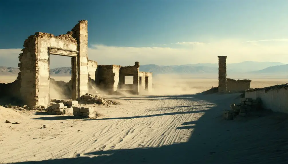
Drought Reveals Lost History
You’ll find the ghostly remnants of St. Thomas emerging from Lake Mead‘s receding waters as severe drought exposes structural foundations, walls, and other architectural features that spent decades underwater.
The concrete ruins and scattered artifacts offer archaeologists and visitors tangible connections to both Mormon pioneer life and earlier Native American settlements in this once-thriving riverside community.
These newly accessible historical remains require careful preservation as fluctuating water levels continue to impact the integrity of the exposed structures.
Lake Levels Expose Ruins
Deep beneath Lake Mead’s waters, the ghost town of St. Thomas has emerged from its watery grave, offering you unprecedented ruins exploration opportunities.
This sight serves as a stark reminder of the many ghost towns in Nevada history that have stories waiting to be uncovered. Each site tells tales of aspiration, hardship, and decay, giving us a glimpse into a bygone era. As you wander through these remnants, you can sense the vibrant life that once filled these now-silent streets.
The history of Saint Joseph, Nevada, is another captivating chapter in this narrative of transformation and abandonment. Once a bustling community, it now stands as a testament to the dreams and challenges faced by its early inhabitants. Exploring its foundations and relics offers an intimate look at the past, revealing the layers of time that have shaped this unique corner of the state.
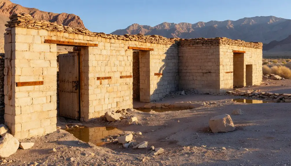
As drought conditions intensify, the submerged history of this Mormon settlement reveals itself through concrete foundations and agricultural remnants that were once hidden under 50-70 feet of water.
You’ll discover these key elements when visiting the exposed ruins:
- Ancient irrigation channels from the Muddy River, showcasing the town’s agricultural heritage
- Water cisterns built with charcoal and sand filtration systems
- Building foundations that tell the story of the last residents who were forced to relocate in 1936
The declining water levels have transformed this once-submerged town into an accessible historical site, though your ability to explore depends on Lake Mead’s fluctuating water levels and desert road conditions.
Historic Structures Reemerge Today
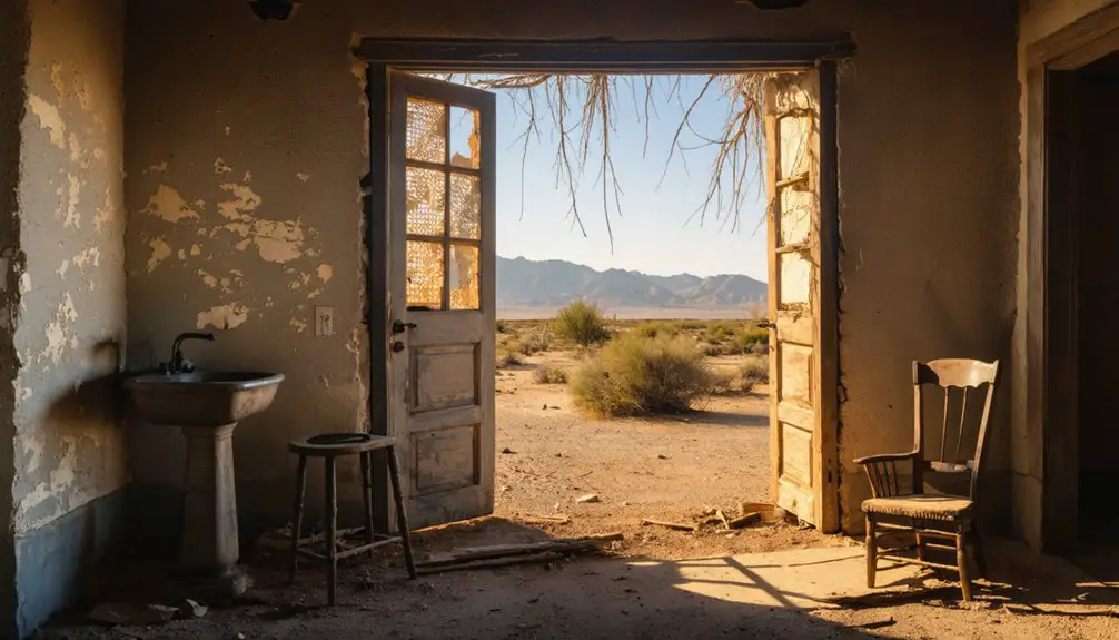
The ongoing drought has revealed a remarkable collection of historic structures throughout St. Thomas. You’ll find concrete foundations of homes, stores, and the iconic Gentry Hotel emerging from Lake Mead’s receding waters. This submerged history offers a fascinating glimpse into early 20th-century pioneer life.
The historic architecture tells a compelling story of adaptation and resilience. You can trace the original street grid where building foundations align with remarkable precision, each site marked by essential water cisterns that once sustained the community.
When you explore these ruins, you’ll discover the remnants of Hank’s Ice Cream Parlor, fence posts, and irrigation systems – all evidence of a thriving town that supported 500 residents before Lake Mead’s waters claimed it in the late 1930s.
Preserving Rediscovered Town Remnants
Since prolonged drought has drastically lowered Lake Mead‘s water levels, St. Thomas’s remnants have emerged from their watery tomb, presenting both archaeological significance and conservation challenges.
You’ll find concrete foundations and structural remains that reveal fascinating insights into Mormon pioneer life and early Nevada settlement patterns.
Preservation efforts now focus on three critical areas:
- Documentation of exposed ruins and collection of surface artifacts during low water periods
- Protection against weathering and vandalism of the once-submerged historical materials
- Management of visitor impact while maintaining public access to this unique heritage site
The Lost City Museum in Overton continues to safeguard artifacts, while state and federal agencies collaborate to monitor site conditions.
You’re witnessing a rare opportunity to study this ghost town’s architecture and community layout, though limited funding and harsh environmental conditions pose ongoing preservation challenges.
Preserving St. Thomas Legacy
Preservation efforts at St. Thomas extend beyond physical ruins to safeguard its cultural significance as a representation of Mormon settlement and early Nevada pioneering.
St. Thomas stands as a living testament to Mormon pioneers who shaped Nevada’s early history through determination and faith.
You’ll find the National Park Service working alongside historical societies to protect this heritage through carefully managed visitor access and educational programs.
When drought exposes the town’s remains, you can explore marked trails that reveal the architectural footprint of original structures, while interpretive signage shares stories of frontier life.
Special events, like reunions of former residents, help maintain community connections to this historic site.
The town’s cyclical emergence from Lake Mead’s waters creates unique opportunities for historical preservation, allowing you to witness firsthand how early settlers engineered water management systems and built thriving communities in Nevada’s challenging environment.
Desert Dreams and Water Politics
Water politics and frontier ambitions collided dramatically in St. Thomas, revealing the harsh realities of settlement challenges in Nevada’s arid landscape.
You’ll find that water rights shaped every aspect of the town’s existence, from its founding through its ultimate submersion beneath Lake Mead.
The town’s complex relationship with water emerged through:
- Initial settlement disputes over jurisdiction between three states, complicating early water access rights.
- Residents’ struggle against government appraisers over fair compensation for their land before flooding.
- The sacrifice of an entire community to create Lake Mead, prioritizing urban water needs over rural preservation.
The desert location forced constant negotiation between survival and growth, while the Boulder Dam Act’s implementation transformed not just St. Thomas, but the entire region’s approach to water management.
Frequently Asked Questions
Are There Any Dangerous Animals or Hazards When Visiting St. Thomas Today?
You’ll need to watch for rattlesnakes and scorpions during wildlife encounters. Take safety precautions against extreme heat, uneven terrain, and sharp debris from old foundations and artifacts.
Can Visitors Take Artifacts Found at the St. Thomas Site?
Preserving precious pieces protects historical significance, so you can’t take any artifacts. It’s strictly forbidden by federal law – doing so damages the site and you’ll face serious penalties for removing items.
What Is the Best Time of Year to Visit St. Thomas?
You’ll find the best season is fall through spring when weather conditions are cooler, letting you explore comfortably. Avoid summer’s extreme heat, and check Lake Mead’s water levels before visiting.
How Deep Was the Water When St. Thomas Was Completely Submerged?
During historical flooding, you’ll find that St. Thomas was submerged under 60 feet (18 meters) of water depth at maximum lake levels, completely covering all structures including the town’s highest building.
Are There Any Surviving Photographs of St. Thomas Before the Flooding?
You’ll find fascinating historic photographs at UNLV’s Special Collections, showing the town’s buildings, streets, and daily life before it vanished underwater. These images now guide underwater exploration when Lake Mead’s levels drop.
References
- https://travelnevada.com/ghost-town/st-thomas-ghost-town/
- https://www.nps.gov/lake/learn/nature/st-thomas-nevada.htm
- https://nvtami.com/2022/03/27/st-thomas-ghost-town/
- https://nevadamagazine.com/issue/september-october-2019/11227/
- https://www.youtube.com/watch?v=JnIIQymTY3w
- https://orc.library.atu.edu/atu_faculty_books/63/
- https://timetraveltrek.com/ghostly-remains-st-thomas-nevada/
- https://www.wef.org/publications/news/wef-news/ghost-town-emerges-from-the-depths-of-lake-mead/
- https://en.wikipedia.org/wiki/St._Thomas
- https://www.stephenwade.com/blog/articles/sunday-drive-the-ghost-town-of-st-thomas-nevada


