
To find hidden Nevada ghost towns, consult historical mining maps from the Nevada Bureau of Mines and Geology, connect with local historical societies, master topographic map reading, follow abandoned railroad grades, join online explorer communities, look for environmental clues like vegetation changes, explore during fall for ideal conditions, document your discoveries, practice ethical exploration, and utilize offline navigation tools. These strategies will grant access to many of Nevada’s 700+ forgotten settlements waiting to be rediscovered.
Key Takeaways
- Study historical mining maps from the Nevada Bureau of Mines to locate forgotten settlements and claim locations.
- Follow abandoned railroad grades and stagecoach trails which often lead directly to ghost towns.
- Visit during fall (September-November) when temperatures are moderate and lighting is ideal for exploration.
- Look for environmental clues like vegetation changes, tailings piles, and mining claim markers.
- Connect with local historical societies for expert insights, rare documents, and specialized tour opportunities.
Consult Historical Mining Maps and Records
To effectively locate Nevada’s hidden ghost towns, you’ll need to first consult historical mining maps and records that document the state’s rich mineral extraction history.
The Nevada Bureau of Mines and Geology maintains extensive Mining District Files containing essential operational timelines, claim locations, and production reports that reveal a town’s historical significance and eventual abandonment.
Explore the Bureau’s Mining District Files—windows into Nevada’s ghost towns through timelines, claims, and production histories.
Focus on specialized maps like Andy Dagosta’s 1969 pictorial representation or interactive digital catalogs documenting over 800 ghost towns with approximate locations. Hickory’s 1976 map published in Carson City offers valuable insights on ghost towns with their corresponding dates and primary mineral deposits.
When practicing map interpretation, cross-reference mineral deposit information with settlement patterns—silver, gold, and copper deposits directly correlate with town establishments and their subsequent collapses when ore depleted.
Publications like Stan Paher’s guides provide additional context about boom-and-bust cycles that shaped Nevada’s mining communities, helping you pinpoint these forgotten places.
Connect With Local Historical Society Members
While historical maps provide valuable starting points, connecting with local historical society members offers unparalleled insights into Nevada’s hidden ghost towns. These experts possess local expertise you won’t find in books—lifetime residents and dedicated historians who can guide you to off-the-map sites and clarify historical timelines. Many of these towns represent the economic boom and bust cycles that shaped Nevada’s development throughout history.
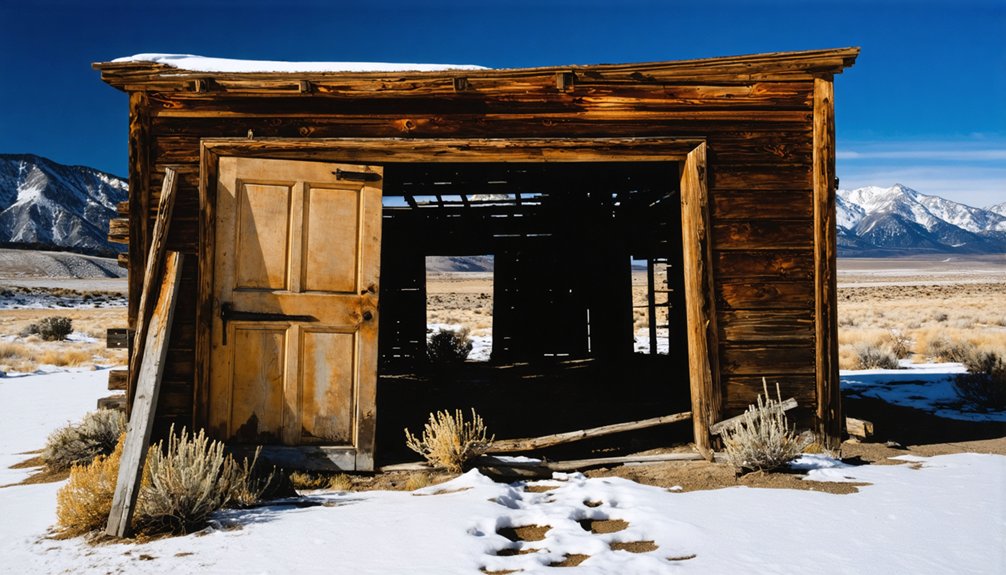
These towns also serve as a testament to the resilience and adaptability of the people who once lived there. The historical significance of nevada’s ghost towns can be felt in their crumbling structures and faded streets, each telling a unique story of hopes and hardships. Exploring these remnants offers a glimpse into a time when prosperity was just a discovery away, only to be overshadowed by the challenges of a frontier life.
By joining historical societies, you’ll gain access to extensive archives containing original documents, rare mining records, and unpublished research. Many collections are partially digitized, but the most valuable materials often require in-person visits. Some members can share personal experiences from Goldfield and other historic mining towns that transformed from tent cities to thriving communities.
You’ll also benefit from society events—lectures, specialized tours, and workshops—that may grant you entry to restricted sites.
Beyond historical insights, these connections support preservation efforts and provide specialized resources, including interactive maps and rare publications documenting Nevada’s forgotten settlements.
To master off-road navigation to hidden Nevada ghost towns, you’ll need to study topographic maps that reveal old mining routes and forgotten pathways once traveled by prospectors.
Always pack survival essentials including water, emergency supplies, and communication devices, as these remote locations often lack cell service and assistance may be hours away.
Following old railway beds and stagecoach trails often provides easier passage through difficult terrain while simultaneously leading you to settlements that once thrived alongside these historical transportation networks.
Bring high-clearance vehicles equipped with proper recovery gear when attempting to reach these remote historical sites, as many ghost towns are accessible only via challenging off-road routes.
Consider downloading offline maps for navigation as cell service is typically unreliable in remote desert locations where ghost towns are found.
Study Topographic Maps
Three essential skills separate novice ghost town explorers from seasoned Nevada backcountry veterans: understanding topographic maps, interpreting terrain features, and maneuvering without cellular connectivity. Your success hinges on mastering topo maps that reveal critical details about a ghost town’s setting.
Learn to read contour lines—closely spaced lines indicate steep terrain potentially hiding mining operations, while widely spaced lines might reveal settlement locations.
Compare topographic features with historical accounts, as many abandoned sites were established near water sources or along trading routes. Recognize elevation changes that influenced settlement patterns, with mining camps often perched on hillsides near ore deposits. Understanding the map’s scale and legend is crucial for accurately measuring distances and identifying trail markers to ghost towns. Start with shorter distances between known points before attempting more challenging off-trail routes to remote ghost towns, beginning with just ½ to 1 mile for your first explorations.
Download offline maps before departure and maintain physical backups.
Practice identifying landmarks that correlate with documented ghost town locations, marking waypoints at potential sites.
Pack Survival Essentials
Seasoned ghost town explorers understand that traversing Nevada’s remote backcountry demands thorough preparation and survival equipment.
Always carry fundamental survival gear: a reliable map and compass, as GPS devices can fail when batteries die. Orienting yourself properly requires keeping the compass away from metal that could interfere with accurate readings. A multi-tool serves countless purposes from gear repair to meal preparation, while a waterproof flashlight enables navigation after sunset or emergency signaling.
Never underestimate Nevada’s harsh environment—pack extra water and high-energy food to sustain yourself during extended explorations.
Your emergency preparedness should include an extensive first-aid kit for treating injuries miles from civilization. Remember that cell service is virtually nonexistent in many ghost town locations, so carry emergency signaling devices like whistles or reflective materials. Using the STOP method when disoriented can prevent panic and help you assess your situation rationally.
These essentials aren’t merely suggestions; they’re critical safeguards that could make the difference between an enriching adventure and a dangerous predicament.
Follow Old Railways
Nevada’s historical railroad networks serve as literal pathways to discovering hidden ghost towns throughout the state’s vast wilderness.
Railroad junctions and depots often mark the original centers of these abandoned settlements, with concrete pads and water towers signaling former stations like Bonnie Claire and Montana.
You’ll find abandoned track beds and right-of-ways still visible even after rails have been removed.
These ghostly corridors lead directly to loading areas and town sites that flourished during Nevada’s railroad history.
Equip yourself with historical maps and aerial imagery to trace exact routes of old lines that modern GPS might miss.
Ghost town exploration often requires traversing rugged off-road terrain where old rail beds have deteriorated into challenging paths.
Document your findings with GPS coordinates and photographs to preserve these historical treasures and assist fellow explorers pursuing similar adventures.
Follow Old Railroad Grades and Stage Routes

Railroad grades and stage routes serve as visible pathways that can lead you directly to Nevada’s hidden ghost towns and mining camps.
You’ll find that historical maps often reveal these transportation corridors, which once connected now-abandoned settlements throughout the state.
Along these routes, you can still discover compelling artifacts such as rusted train cars, crumbling bridges, abandoned stations, and weathered stage stops that testify to Nevada’s bustling transportation networks.
Maps Reveal Pathways
Explorers of Nevada’s ghost towns benefit immensely from historical maps that document the extensive network of abandoned transportation routes throughout the state.
These maps reveal over 700 ghost towns, including mining settlements and stage stations, preserving their historical significance and precise locations. You’ll find abandoned railroad grades, emigrant trails, and the Old Spanish Trail clearly marked, guiding you directly to these forgotten places.
Modern mapping techniques have transformed exploration, with interactive digital maps providing GPS coordinates for more than 500 ghost towns.
When you overlay historical photographs with current satellite imagery, you can pinpoint remaining structures and confirm site locations.
These maps illustrate how transportation history shaped Nevada’s development—towns flourished along rail lines and stagecoach routes, then faded when those lifelines disappeared.
Following these pathways leads you directly to Nevada’s most intriguing abandoned settlements.
Transportation Artifacts Remain
Weathered ties and rusted rails crisscrossing Nevada’s harsh landscape serve as silent guides to the state’s most elusive ghost towns.
These transportation history elements often lead directly to abandoned settlements where stagecoach stops and railroad depots once bustled with activity.
Follow these historic pathways, and you’ll discover Rhyolite, Goldfield, and other forgotten places where artifact preservation efforts maintain America’s frontier legacy.
- Look for rusted train cars, mile markers, and track remnants that signal proximity to hidden settlements
- Navigate using old railroad grades as makeshift trails through remote terrain
- Identify former stagecoach routes running parallel to railroad lines for additional access points
- Search near abandoned bridges and tunnels, which often indicate nearby ghost towns requiring railway infrastructure
Join Online Ghost Town Explorer Communities
While physical exploration of Nevada’s ghost towns provides incomparable firsthand experiences, connecting with online communities can substantially enhance your research capabilities and on-site adventures.
Forums and message boards offer detailed location data and seasonal recommendations, while social media groups facilitate ghost town photography exchanges and historical preservation discussions.
Consider joining membership-based organizations that provide exclusive access to archived documents and expert-led field trips.
Specialized apps and interactive maps will improve your navigation through Nevada’s rugged terrain, offering GPS coordinates for remote sites not found in standard guides.
Don’t overlook video channels featuring virtual tours that allow you to assess site conditions before visiting.
These online resources not only connect you with fellow explorers but also guarantee you’re practicing ethical visitation—protecting these fragile historical treasures for future generations.
Interview Longtime Nevada Residents

Who better understands Nevada’s ghost towns than those who’ve witnessed their gradual transformation over decades? Longtime residents provide invaluable oral histories that aren’t captured in official records. When interviewing these knowledge keepers, prepare open-ended questions about local legends, mining booms, and forgotten settlements.
- Record conversations to preserve nuanced details about abandoned structures and their histories.
- Seek out residents at local museums, veteran communities, and town halls for the most accurate information.
- Cross-reference their accounts with historical maps to verify locations of lesser-known sites.
- Respect privacy boundaries when discussing potentially sensitive historical events.
These firsthand accounts reveal hidden access routes, identify hazardous areas to avoid, and provide context about why towns were abandoned—whether from mineral depletion, economic shifts, or natural disasters.
Their stories bring Nevada’s ghost town landscape to life.
Search for Environmental Clues in the Landscape
When searching for Nevada’s ghost towns, you’ll notice mining claim markers and stakes that often remain long after buildings have disappeared.
Changes in vegetation, including unusual clusters of non-native plants or trees marking former homesteads, provide compelling evidence of human settlement in the desert landscape.
These botanical anomalies, combined with disturbed soil patterns and tailings piles, can reveal a town’s layout and purpose even when structural remnants are minimal.
Mining Claim Markers
Scattered across Nevada’s rugged landscape, mining claim markers serve as silent sentinels of the state’s prospecting past. When exploring potential ghost town sites, proper marker identification and boundary observation will guide your search.
Look for wooden posts, stone cairns, or metal tags bearing names and dates at claim corners. These artifacts often align with topographical features, following ridgelines or perpendicular to mountain contours where mineral-rich veins once promised fortune.
- Blazed trees or nailed markers along linear vegetation patterns indicate historical claim boundaries
- Soil disturbances and rock piles reveal excavation points and tailings deposits
- Ditches or small dams suggest water diversion systems essential for mining operations
- Claim markers near natural landmarks like quartz outcrops typically denote strategic mining positions
Vegetation Patterns Reveal History
Nevada’s ghost towns reveal their secrets not only through physical ruins but also through distinctive vegetation patterns that emerge after abandonment. As you explore barren landscapes, watch for dense patches of bunch-grass or pioneer shrubs like creosote and sagebrush—these often mark former town sites where vegetation succession has accelerated since human disturbance ended.
Building foundations create microhabitats retaining moisture, supporting lusher growth than surrounding desert. Linear arrangements of plants might indicate old streets, while unusual non-native species suggest past gardens.
The ecological recovery timeline provides clues to abandonment dates: bunch-grass appears within years, shrubs within a decade, and stabilized patterns after 20-30 years. Soil compaction from former roads slows recovery, creating visible gaps that map the town’s layout even when structures have vanished.
Create a Seasonal Exploration Strategy
Planning your ghost town explorations strategically around Nevada’s distinct seasons can greatly enhance both safety and enjoyment.
Fall (September-November) offers favorable conditions with clear skies and moderate temperatures, while spring presents wildflower displays amidst mild weather.
Winter explorations require daylight planning to compensate for shorter days, and summer visits should generally be avoided due to extreme heat risks.
- Fall expeditions allow longer exploration windows with excellent photography lighting during early mornings and late afternoons.
- Spring adventures offer unique opportunities to witness historic sites framed by desert blooms.
- Winter visits demand extra preparation for potential snow at higher elevations and strict turnaround times.
- Pre-trip research should include seasonal road closure information, as access conditions vary dramatically throughout the year.
Properly documenting your ghost town discoveries transforms fleeting explorations into lasting contributions to Nevada’s historical record. Capture precise GPS coordinates, physical conditions, and historical context using a combination of photography, detailed note-taking, and mapping software.
Record unique artifacts and environmental features that tell the site’s story. Develop a consistent cataloging system for your documentation techniques, storing files in both digital archives and physical copies.
Cross-reference your findings with existing historical records to validate discoveries and add depth to your research. Share your work through specialized online platforms like ghost town forums, photographic exhibits, and historical society publications.
Your carefully documented adventures not only preserve these vanishing places but inspire fellow explorers while respecting the freedom these abandoned spaces represent.
Practice Ethical Ghost Town Exploration
Ethical exploration forms the cornerstone of responsible ghost town visitation, preserving Nevada’s fragile historical sites for future generations.
When venturing to these abandoned settlements, your actions directly impact their longevity. Proper ghost town ethics demand respecting private property boundaries, preserving historical integrity, and practicing environmental awareness.
Every footprint you leave in a ghost town shapes its future — tread with reverence and responsibility.
- Never remove artifacts or disturb structures—even small items like nails contribute to the site’s historical context.
- Observe all posted signs and obtain written permission when exploring privately owned ghost towns.
- Follow “Leave No Trace” principles by avoiding new trails and keeping sites exactly as you found them.
- Support local communities by hiring guides and patronizing nearby businesses, strengthening preservation practices.
Remember: these aren’t theme parks but fragile windows into Nevada’s past that deserve your careful stewardship.
Frequently Asked Questions
How Dangerous Are Abandoned Mine Shafts in Ghost Towns?
Abandoned mine shafts in ghost towns are extremely dangerous. You’ll encounter deadly hazards including sudden collapses, toxic gases, and 190-foot drops. Ghost town hazards require serious mine safety awareness.
Is Metal Detecting Allowed in Nevada Ghost Towns?
The metal detector—a modern intrusion on history’s dust—isn’t freely welcomed in Nevada ghost towns. You’ll need specific ghost town permits due to strict metal detecting regulations protecting artifacts over 100 years old.
What Emergency Supplies Should I Carry When Ghost Town Hunting?
Carry safety gear including a multi-tool, GPS with offline maps, and signaling devices. Don’t forget first aid supplies, water purification, emergency shelter, and extra clothing for Nevada’s extreme conditions.
How Do I Identify Authentic Artifacts Versus Modern Trash?
The monumentally vital aspect of artifact identification lies in historical context. Examine materials (avoid plastic/aluminum), look for authentic patina and weathering, and note where you’ve found it—location often tells the artifact’s true story.
Are There Ghost Towns Accessible Without High-Clearance Vehicles?
Yes, you’ll find numerous Nevada ghost towns with excellent accessibility. Goodsprings, Nipton, Calico, Pioche, and Rhyolite require no special vehicle requirements—all are reachable via paved or well-maintained gravel roads.
References
- https://nvtami.com/nevada-ghost-towns-map/
- https://www.visittheusa.com/experience/6-nevada-ghost-towns-explore-if-you-dare
- https://www.youtube.com/watch?v=nxPe2UupWr4
- https://www.youtube.com/watch?v=kg18CwWeMnc
- https://www.youtube.com/watch?v=DsM2_lKk8V8
- https://travelnevada.com/ghost-town/
- https://www.youtube.com/watch?v=lXyHDThvoLU
- https://nvtami.com
- https://www.everand.com/book/499927478/Old-Heart-Of-Nevada-Ghost-Towns-And-Mining-Camps-Of-Elko-County
- https://www.geotab.com/ghost-towns/