You won’t find Vaca Adobe standing today – this historic 1842 structure was completely destroyed in the 1892 Vacaville-Winters earthquake. Built by Juan Manuel Vaca with indigenous laborers using traditional sun-dried brick techniques, it once anchored his 44,384-acre Rancho Lihuaytos. While the adobe vanished, it sparked the town of Vacaville through Vaca’s 1850 land sale. The nearby Peña Adobe remains as the sole tangible connection to this founding era.
Key Takeaways
- Vaca Adobe was completely destroyed in the 1892 earthquake, leaving no physical traces of the original structure today.
- The adobe’s destruction contributed to its “ghost town” status, with only the neighboring Peña Adobe surviving from that era.
- The original Vaca homestead site now exists primarily through historical documentation rather than physical remains.
- Peña Adobe Park preserves the memory of the settlement, offering visitors a glimpse into California’s rancho period.
- Unlike a traditional ghost town, Vacaville developed into a thriving city while its namesake adobe disappeared.
The Rise and Fall of Juan Manuel Vaca’s 1842 Adobe Homestead
In 1842, amidst the shifting political landscape of Mexican California, Juan Manuel Vaca established what would become a significant but ultimately short-lived adobe homestead in present-day Solano County.
The structure rose from the fertile Laguna Valley soil under the hands of 25 indigenous laborers, featuring imposing two-foot thick walls constructed from massive sun-dried bricks measuring 23″x10″x3″.
From native hands emerged an architectural testament to permanence—two-foot adobe walls anchoring California dreams into the Laguna Valley earth.
You’ll recognize the Vaca legacy in this architectural evidence of early California settlement—dirt floors supported daily life while hand-hewn redwood timbers from Napa formed the roof. Unfortunately, the Vaca Adobe was completely destroyed by a devastating earthquake in 1892.
This adobe homestead wasn’t merely shelter but a physical claim to the 44,384-acre Rancho Lihuaytos (later Rancho Los Putos) that Vaca and his partner Juan Felipe Peña secured through Mexican land grant in 1843, establishing a foothold that would ultimately birth the town of Vacaville itself.
The land selection reflected Vaca’s practical sensibilities, chosen specifically for its proximity to creeks and pleasant summer breezes that made the location ideal for ranching operations.
Adobe Construction: Building Techniques of Early California Settlers
The thick-walled adobe homestead Juan Manuel Vaca constructed reflected building techniques that had been perfected over generations throughout the Southwest.
You can still witness the marriage of Spanish and indigenous methods in the remains—walls formed from sand, clay, straw, and water that stand as evidence of sustainable architecture.
These settlers didn’t simply stack bricks; they wove them in alternating patterns atop stone foundations that prevented moisture damage. The ideal composition for their adobe typically contained 15% clay with appropriate amounts of silt and fine sand to prevent cracking while ensuring durability.
The structure’s massive vigas supported roofs layered with reeds and adobe mud, creating natural insulation against California’s temperature extremes.
When wet, this roof expanded to form a waterproof membrane—ingenious climate adaptation using only local resources.
The adobe materials required communal effort to gather, mix, and form, fostering the self-reliance valued by early California pioneers seeking freedom on the frontier.
Similar to the two-foot thick walls found in the historic Mission Adobe of Santa Cruz County, these structures provided natural temperature regulation throughout the seasons.
From Ranch to Town: How Vaca’s Land Sale Created Vacaville
Juan Manuel Vaca’s fateful decision to sell 9 square miles of his Mexican land grant in 1850 transformed what was once expansive ranchland into the foundation of modern Vacaville.
The transaction with William McDaniel, a federal land agent, established a pivotal moment in local land development despite its controversial nature.
For $3,000 and 1,044 town lots, Vaca relinquished control of his property under these conditions:
- McDaniel would establish a 1-square-mile townsite
- The new settlement would bear Vaca’s name
- The deal would provide economic opportunity for settlers
- The transaction would create a trade hub for regional commerce
This land agreement sparked a bitter family feud with Vaca’s compadre Pena, who resented the town being named solely after Vaca.
You’re witnessing the consequences of this disputed agreement today—a transaction that left Vaca’s family land-rich but cash-poor while permanently inscribing their legacy on California’s map.
The land was originally part of Rancho Los Putos, granted to Vaca and Juan Felipe Peña in 1843 by the Mexican government.
The Great Earthquake of 1892: Death of a Historic Structure
Striking with unprecedented force, the Vacaville-Winters earthquake sequence of 1892 forever altered the region’s historical landscape when it destroyed the iconic Vaca Adobe, one of the area’s oldest structures.
The doublet quakes, measuring 6.4 and 6.2 on the Richter scale, ravaged nearly all brick buildings in Vacaville. You’d have witnessed violent shaking across a vast area—felt from Redding to Fresno and as far east as Nevada.
The earthquake impact was catastrophic: twisted chimneys, rockslides, and approximately $250,000 in damages (1892 dollars). While the Peña Adobe survived, the Vaca family’s original 1840s home crumbled completely. The area near Allendale experienced the most severe destruction, with intensity IX reported alongside visible ground fissures.
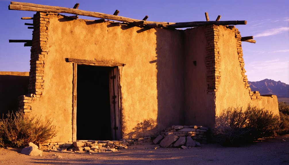
The historical significance of this destruction remains profound. With the adobe’s collapse, you lost physical access to a cornerstone of local heritage, leaving the Peña Adobe as Solano County’s sole remaining structure from that founding era. This historic Peña Adobe is located just one mile west of Vacaville on U.S. 40.
Remembering What’s Lost: Historical Preservation at Peña Adobe Park
While the Vaca Adobe exists only in historical records after its destruction in 1892, preservation efforts have concentrated on its surviving counterpart—the Peña Adobe—which now stands as the centerpiece of a dedicated historical park.
When you visit today, you’ll find a site meticulously maintained by the Peña Adobe Historical Society (founded 2004), which tackles preservation challenges through strategic community involvement.
The society’s work guarantees this piece of California’s pioneer legacy remains intact for future generations. The historical significance of the Peña Adobe is underscored by its status as the oldest structure in Solano County.
Through dedicated preservation efforts, the pioneers’ California dream lives on for tomorrow’s heritage seekers.
Key preservation initiatives include:
- Monthly living history demonstrations highlighting pioneer and Indigenous cultures
- Securing a $100,000 grant for pond restoration from California State Parks
- Volunteer-led educational programs and interpretive tours
- Management of the Mowers-Goheen Museum and surrounding cultural features
The park’s 470 acres of natural landscape provides a beautiful backdrop to the historical preservation efforts while offering numerous recreational opportunities for visitors.
Frequently Asked Questions
Were Other Family Members Involved in Managing the Vaca Adobe?
Yes, you’ll find family involvement extended beyond Juan Manuel Vaca, with children helping in ranch activities, Native American workers participating, and women like Nestora demonstrating critical management dynamics after male relatives died.
What Artifacts From the Vaca Adobe Survive Today?
You’ll find no direct artifacts from the Vaca Adobe survived the 1892 earthquake. Its historical significance lives through preservation efforts, documented records, and comparative context from the nearby Peña Adobe instead.
How Did Native Americans View Their Role in Adobe Construction?
You’d see Native Americans viewed their participation in adobe construction as preserving cultural significance while adapting traditional construction techniques—a communal practice embodying their heritage, ecological knowledge, and resistance to colonial erasure.
What Crops and Livestock Were Raised at the Vaca Ranch?
You’d find diverse operations at Vaca Ranch: Spanish Longhorn cattle farming dominated, complemented by sheep herds. They implemented systematic crop rotation of wheat, barley, and hay, later adding fruit orchards for economic resilience.
Did Any Notable Historical Figures Visit the Vaca Adobe?
You’ll find that historical records don’t document famous visitors to Vaca Adobe, despite its historical significance as California’s oldest Solano County structure. The adobe’s isolation likely limited notable guest encounters.
Exploring other historical landmarks in the region, such as historic mining sites near Bridgeport, reveals a rich tapestry of stories waiting to be uncovered. These locations not only highlight the mining boom of the past but also serve as a testament to the resilience of early settlers. Each site offers a glimpse into the lives and struggles of those who sought fortune in the rugged terrain.
References
- https://www.solanoarticles.com/history/index.php/weblog/more/the_vacas_and_pena_land_holdings/
- https://walkiesthroughhistory.com/2023/01/08/pena-adobe/
- https://www.solanoarticles.com/history/index.php/weblog2/more/pena_adobe_has_a_colorful_history/
- https://www.penaadobe.org/about
- https://ohp.parks.ca.gov/ListedResources/Detail/534
- https://www.yourtownmonthly.com/2021/05/vacavilles-lagoon-valley-park-a-rich-history/
- https://evendo.com/locations/california/northern-california/landmark/vaca-pena-adobe-california-historical-landmark-534
- https://www.solanoarticles.com/history/index.php/weblog2/more/juan_manuel_vaca_the_don_of_vacaville/
- https://www.fentonscreamery.com/little-known-history-of-vacaville-california
- https://www.nps.gov/articles/000/apolonia-vaca-and-nestora-pena-the-old-spanish-trail.htm


