You’ll find the original town of Vantage submerged beneath Lake Wanapum’s waters, where it once served as a crucial Columbia River crossing point until 1962. The Wanapum Dam’s construction forced the relocation of this historic settlement 1.5 miles upstream, transforming a bustling ferry stop and bridge crossing into an underwater ghost town. Today’s Vantage sits higher above the reservoir, where traces of its past reveal a deeper story of community resilience and change.
Key Takeaways
- The original Vantage townsite was submerged in the 1960s by the creation of Wanapum Dam’s reservoir, forcing relocation 1.5 miles upstream.
- Historic buildings and infrastructure were physically moved to higher ground when the town relocated, preserving some original structures.
- Vantage transitioned from a river commerce hub to a ghost town after flooding, though some highway-oriented services remain.
- Remnants of the old town lie beneath Lake Wanapum, attracting cultural tourists interested in Washington’s submerged history.
- The ghost town experience includes preserved structures, interpretive signs, and walking trails that tell Vantage’s story of displacement.
The Birth of a River Community
Along the banks of the Columbia River, Vantage emerged as an essential crossing point when W.D. Van Slyke established his ferry service in pioneer times.
W.D. Van Slyke’s pioneering ferry service transformed Vantage into a vital Columbia River crossing, connecting early settlers across its powerful waters.
You’ll find this strategic location served as a significant vantage point where early settlers could navigate across the mighty Columbia’s waters, connecting travelers to both sides of the rugged terrain.
The ferry history of this remote outpost tells a story of determination, as pioneers relied on Van Slyke’s transport to forge paths through Washington’s untamed landscape. The area held deep significance for Wanapum Native people, who had fished these waters for generations.
In 1927, progress arrived in the form of a massive steel cantilever bridge stretching 2,475 feet across the river.
At $628,000, this engineering marvel, built by a Portland firm, marked the end of the ferry era and solidified Vantage’s role in the region’s transportation network. The landscape features dun-colored sage and red-brown rocks stretching across the surrounding countryside.
Life Along the Columbia’s Edge
You’d find the early life in Vantage centered around its primitive car ferry service, where wooden planks and chains secured automobiles for the precarious crossing of the Columbia River.
Daily scenes at the ferry landing included local fishermen casting their lines while travelers waited their turn, often witnessing the heart-stopping moments when cars with unreliable brakes threatened to slip into the rushing waters below.
The ferry operators worked tirelessly from 1914 until 1927, when the first steel bridge finally modernized the crossing and transformed river life for the small community.
The simple vessel could transport only two cars at a time across the waters, creating long queues of waiting vehicles during busy periods.
Local history changed dramatically when workers descended into pressurized caissons 70 feet beneath the riverbed to construct the bridge’s foundation.
River Community Daily Life
The Columbia River’s edge shaped two distinct ways of life in early Vantage, with the Wanapum people’s 12,000-year fishing traditions existing alongside settler farming communities.
You’d have found the Wanapum’s river rituals deeply woven into their identity as River People, with seasonal fishing traditions dictating their social gatherings and spiritual practices. The Wanapum Heritage Center today preserves these ancestral stories through peaceful cultural adaptation to changing times.
Meanwhile, settlers established farms along the fertile riverbanks, integrating agriculture with the natural rhythms of the Columbia. The semi-arid landscape’s harsh conditions meant you couldn’t survive without adapting to the river’s cycles.
Life centered around the water’s edge, where you’d witness both cultures finding sustenance – the Wanapum continuing their ancient fishing practices while settlers developed crops and ran livestock on the banks, creating a unique blend of traditional and modern river-based survival.
Fishermen and Ferry Tales
Life at the Columbia’s edge grew more complex as commercial fishing operations emerged alongside traditional Native practices in the late 1800s.
You’d find fish wheels churning alongside indigenous scaffolding platforms, while the Wanapum people maintained their fishing rights and cultural heritage despite rapid changes. Traditional fishermen used long-handled dipnets to catch salmon from specially constructed platforms along the shore.
Van Slack’s ferry service bridged communities until 1927, connecting fishermen and traders across the mighty Columbia. The 1855 Indian treaties helped preserve access to traditional fishing grounds for native tribes, though tensions remained.
- Fish wheels and gill netters battled over salmon prices, leading to strikes and the formation of CRFPU in 1886
- Native tribes preserved their fishing traditions through 1855 treaty rights at “usual and accustomed places”
- Wanapum people remained resilient, following prophets like Smohalla who advocated maintaining traditional ways
- Commercial fishing operations sparked conflicts as salmon populations declined
- Ferry operations supported both indigenous and commercial fishing economies until bridge construction
The Dam Projects That Changed Everything
You’ll find it hard to imagine the transformation that struck Vantage in the early 1960s when the Wanapum Dam‘s rising waters forced the town’s complete relocation to higher ground.
The 796,000 acre-feet reservoir swallowed the original townsite, permanently altering life along the Columbia River’s edge where residents had lived and worked for generations.
Located six miles downstream from Vantage, the Wanapum Dam dramatically changed the river’s flow and character.
Grant County PUD’s massive dam project didn’t just reshape the physical landscape – it reshaped an entire community’s future as the old steel cantilever bridge was dismantled and a new crossing was built to span the widened waters.
The dam would go on to see major improvements, including a 44-year license extension in 2008 that mandated modernization and habitat protection measures.
Rising Waters, New Reality
During the early 1960s, massive changes transformed Vantage’s landscape as Wanapum Dam’s construction impounded the Columbia River, creating a 796,000 acre-foot reservoir that submerged much of the original townsite.
The rising tides reshaped not just the physical terrain but sparked a complete community transformation. The Grant County PUD took charge of operating the dam to provide essential hydroelectric power to the region.
You’ll find the story of adaptation in the new steel bridge that replaced the 1927 cantilever crossing, and in the rerouted Interstate 90 that now spans Lake Wanapum’s widened waters.
- Original bridge dismantled and relocated to Lyons Ferry
- Native Wanapum sites submerged beneath reservoir waters
- Fish migration patterns disrupted by altered river flow
- Traditional cultural landscapes forever changed
- New recreational opportunities emerged on Lake Wanapum
Relocating an Entire Town
As Wanapum Dam’s construction loomed on the horizon in 1959, Grant County PUD and the Washington State Highway Commission forged a critical $4.5 million agreement that would reshape Vantage’s destiny.
The town planning challenge was immense: you’d need to relocate an entire community uphill before Lake Wanapum’s waters could swallow the original townsite. A new 2,500-foot bridge would rise 1.5 miles downstream from the old one, while Interstate 90’s path required careful realignment.
Despite having only 30 residents, Vantage’s community resilience shone through as buildings and infrastructure moved to higher ground. The shift transformed the town’s economic focus from river commerce to highway-oriented services.
The original 1927 steel bridge found new life at Lyons Ferry, while Vantage adapted to its new reality above the reservoir’s reach.
Life After the Floods
The construction of Wanapum Dam in 1962 marked the beginning of dramatic changes for Vantage and the Columbia River ecosystem.
You’ll find that community resilience emerged as residents adapted to their new townsite, positioned safely above flood levels. The flood recovery period transformed both the physical and social landscape, shifting from a natural river valley to a managed reservoir system.
- The 1927 Vantage Bridge found new life as the Lyons Ferry Bridge on the Snake River
- Dam-controlled waters replaced the seasonal flood patterns that shaped the land for millennia
- New recreational opportunities emerged on the reservoir waters
- Traditional river-based commerce adapted to reservoir conditions
- Environmental changes demanded new conservation and mitigation strategies
The dam projects forever altered the region’s identity, trading natural river dynamics for engineered water management and reshaping how people interact with the Columbia River.
Relocating a Town’s Heart and Soul
When rising waters from the Wanapum Dam threatened to submerge Vantage in the early 1960s, residents faced the challenging task of relocating their entire community two miles uphill from its original riverside location.
In a remarkable display of community resilience, they preserved their social bonds while adapting to an entirely new geographic setting.
You’ll find that the relocation involved more than just moving buildings – it meant abandoning roads, infrastructure, and familiar landmarks that had defined life along the Columbia River.
Yet through historical preservation efforts, the town’s memory lives on in artifacts beneath Lake Wanapum’s waters.
While the original Vantage now rests underwater, its spirit endures in the new location, where residents maintain their deep connection to the river and surrounding landscape that first drew settlers to this distinctive place.
Ancient Treasures: The Ginkgo Connection
Near the relocated town of Vantage lies an extraordinary prehistoric treasure: petrified wood dating back 15.5 million years, discovered by highway workers in 1927.
You’ll find this remarkable site at the Ginkgo Petrified Forest State Park, where ancient logs turned to stone tell stories of a dramatically different landscape. The park’s cultural significance extends beyond its geological wonders, featuring Indigenous petroglyphs that connect human history with natural heritage.
- Professor George Beck’s pioneering research established the site’s scientific importance
- The forest contains diverse species including Ginkgo, maple, Douglas fir, and elm
- Lava flows and Ice Age floods contributed to the petrification process
- The interpretive center showcases Washington’s official state gem
- Ancient petroglyphs demonstrate the area’s significance to Indigenous peoples
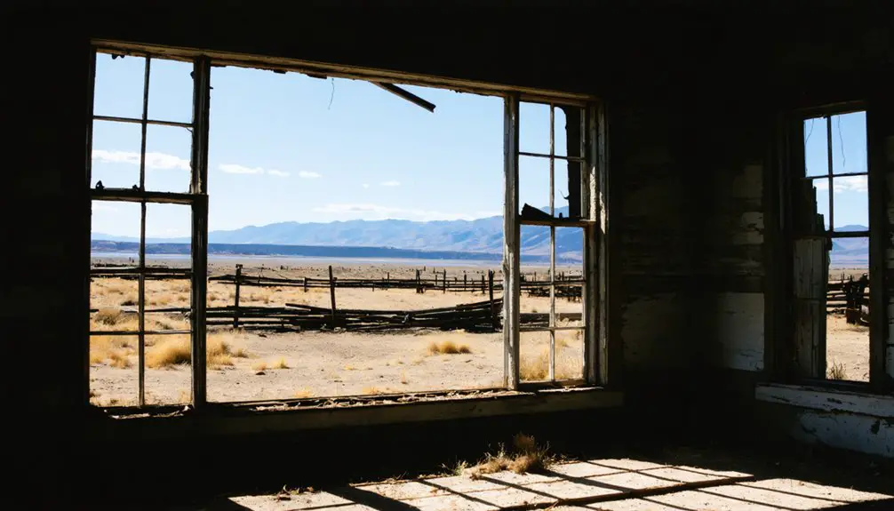
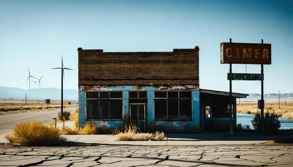
What Remains: Traces of the Past
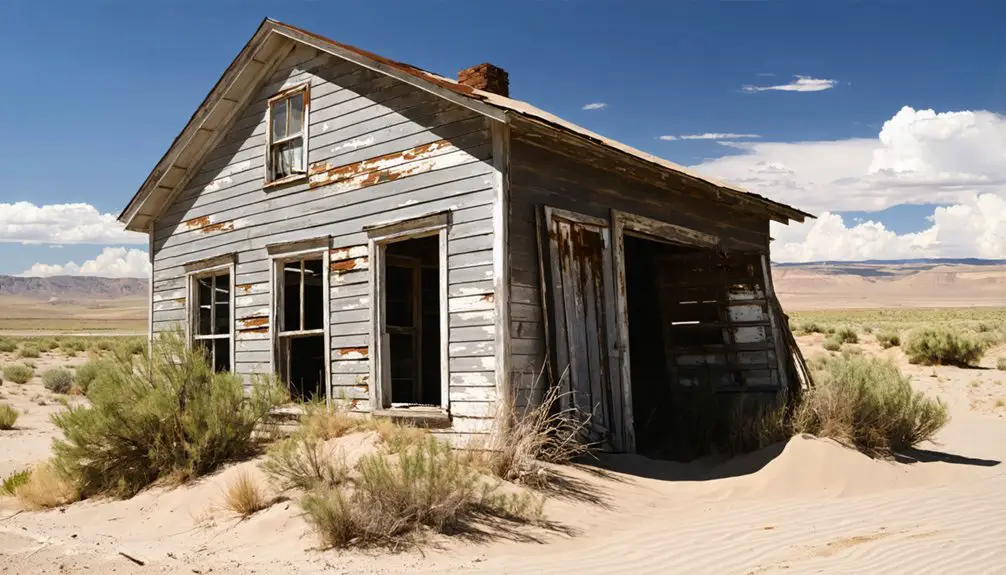
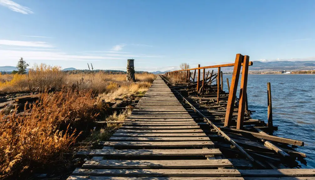
Standing silent among desert scrubland, original structures from Vantage’s heyday still dot the landscape along the Columbia River’s former banks.
You’ll discover stone foundations marking old homes and businesses, while rusted rail tracks peek through the soil near the deteriorating train depot.
As you explore, you’ll encounter visible artifacts scattered throughout the ghost town – broken bottles from the early 1900s, discarded tools, and machinery parts that tell stories of past industry.
The surrounding terrain reveals abandoned orchards and eroded wagon trails, while old irrigation ditches cut through overgrown farmland.
Local heritage groups have worked to stabilize key remaining structures and placed informational placards to guide your journey through time.
Dedicated preservation efforts protect Vantage’s historic remnants, while interpretive signs help visitors explore this window into Washington’s past.
Archaeological surveys continue to uncover new traces of Vantage’s pioneering past.
Natural Wonders and Historical Legacy
Beyond the weathered remains of old Vantage lies a remarkable geological treasure: the Ginkgo Petrified Forest State Park, where 15.5-million-year-old fossilized trees tell stories of ancient landscapes.
As you explore this unique area, you’ll discover how ancient volcanic activity and Ice Age floods carved out dramatic geological formations along the Columbia River. The desert-like terrain you see today represents incredible ecological adaptations, from resilient sagebrush to wildlife that thrives in the harsh climate.
- Petrified wood specimens include ginkgo, maple, Douglas fir, and elm – now Washington’s state gem
- Originally discovered during 1927 highway construction
- Museum and interpretive trails showcase the region’s natural history
- Area transformed by dam projects, flooding the original townsite
- Desert shrubland now dominates where ancient forests once stood
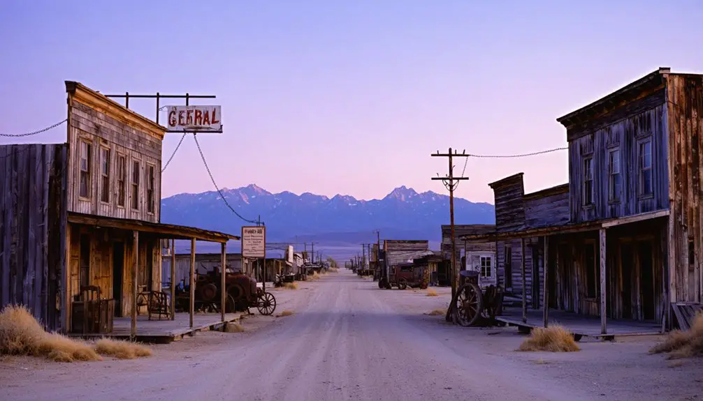
The Ghost Town’s Modern Identity
Today’s Vantage ghost town embraces a unique dual identity as both a historical site and a vibrant recreational area.
exploring ghost towns near Vantage offers visitors a glimpse into the region’s rich history while providing opportunities for outdoor adventures. From hiking trails to scenic viewpoints, these deserted areas attract explorers eager to uncover forgotten stories. Each ghost town presents a unique backdrop for photography and reflection, making them a must-visit for those seeking a blend of history and nature.
The history of orient ghost town adds another layer of intrigue to the exploration. Visitors can learn about the lives once led in this area and the circumstances that led to its abandonment. As they wander through the remnants, each crumbling structure tells a story waiting to be discovered.
You’ll find well-maintained trails for walking, jogging, and biking, alongside preserved historic structures that tell tales of Washington’s mining past. The site’s recreational preservation approach has transformed it into a multipurpose park with modern amenities like restrooms, walking bridges, and even a frisbee golf course.
As a hub for cultural tourism, Vantage draws photographers seeking to capture its haunting beauty and starlit skies.
You’re free to explore the grounds while following safety guidelines near marked structures. The ghost town’s integration of outdoor activities with historical elements sets it apart from other abandoned settlements, making it a distinctive destination where you can experience both adventure and heritage.
The history of Sherman, Washington ghost town is rich with stories of early settlers and the challenges they faced. As you wander through the remnants of this once-thriving community, you’ll gain insight into the lives and cultures that shaped the area. Each structure has its own tale to tell, adding layers of intrigue to your adventure.
Frequently Asked Questions
What Was the Population of Vantage at Its Peak?
While Vantage’s history doesn’t record exact peak numbers, you’ll find that before its population decline, the town likely never exceeded a few hundred residents during its mid-20th century peak.
Are There Any Underwater Diving Opportunities to View the Original Townsite?
While underwater exploration of Vantage’s submerged townsite is technically possible, you’ll find no official diving operations due to challenging reservoir conditions and historical preservation concerns in Lake Wanapum’s cold, low-visibility waters.
Did Any Original Vantage Buildings Survive the Relocation Process?
Like shadows fading at sunset, no original structures from old Vantage survived intact. While historical preservation wasn’t prioritized, the town’s spirit lived on as residents rebuilt completely new buildings uphill.
What Native American Tribes Originally Inhabited the Vantage Area?
You’ll find the Wanapum tribe originally inhabited Vantage’s Columbia River banks, while the Chinook and Yakama nations shared cultural significance in the broader region’s tribal history through trade and settlements.
How Accessible Is the Ghost Town Site During Different Seasons?
You’ll find year-round access by 2WD vehicles, with best road conditions in summer. Winter can bring icy roads requiring caution, while spring and fall offer variable seasonal accessibility depending on weather.
References
- https://www.pnwanderers.com/blog/a-trip-through-history-at-ginkgo-petrified-forest-state-park
- https://map.proxi.co/r/Washington_Ghost_Towns
- https://en.wikipedia.org/wiki/List_of_ghost_towns_in_Washington
- https://www.ghosttowns.com/states/wa/vantage.html
- https://www.seattlepi.com/seattlenews/article/Spooky-Washington-ghost-towns-12992053.php
- https://www.postalley.org/2023/02/07/great-advantage-the-river-people-at-the-center-of-washington-state/
- https://revisitwa.org/waypoint/vantage/
- https://www.youtube.com/watch?v=J0U9GiLbAkI
- https://washingtonourhome.com/columbia-gorge-overlook-and-the-wanapum-indian-tribe/
- https://www.grantpud.org/history