You’ll find Washakie as a ghost town in northern Utah that emerged from a unique collaboration between Mormon settlers and Northwestern Shoshone Native Americans in the 1880s. The settlement, named after influential Chief Washakie, thrived through agricultural development and religious conversion until its decline in the mid-1900s. Today, the abandoned town’s LDS chapel, listed on the National Register of Historic Places, and its cemetery stand as silent witnesses to this remarkable cultural intersection.
Key Takeaways
- Washakie was a Northwestern Shoshone settlement established in 1880 with a 1,700-acre farm focused on agriculture and Mormon religious practices.
- The town’s development centered around Chief Washakie’s leadership, irrigation systems, and successful farming operations through the early 1900s.
- Population decline began in the 1940s due to limited economic opportunities, decreased church support, and isolation from major markets.
- The last residents departed in the mid-1970s, leaving behind the historic LDS chapel and schoolhouse as remnants of the community.
- The site is now recognized as a ghost town with its LDS chapel listed on the National Register of Historic Places.
The Birth of a Native American Settlement
After the devastating Bear River Massacre of 1863, which left only 1,250 Northwestern Shoshone survivors, the tribe faced critical decisions about their future in northern Utah.
In the wake of tragedy, the Northwestern Shoshone people stood at a crossroads, confronting the harsh realities of survival and adaptation.
Under the guidance of Eastern Shoshone leader Chief Washakie, the tribes demonstrated remarkable adaptability in this era of dramatic change.
You’ll find their story marked by resilience as they navigated the challenging shift from nomadic life to agriculture. In 1873, their conversion to Mormonism sparked a period of cultural exchange that would reshape their community.
The LDS Church’s efforts to establish Indian farms began in 1874 near Franklin, Idaho, where missionary George Washington Hill helped the Shoshone learn farming techniques.
Chief Washakie’s deep connection to Mormon culture was evident through his friendship with Brigham Young, which helped facilitate peaceful relations between the Shoshone and Mormon settlers.
Despite setbacks at early farm sites, including irrigation problems and seasonal abandonment, the agricultural adaptation continued.
Chief Washakie’s Legacy and Influence
While the Northwestern Shoshone established their new settlement, Chief Washakie’s influence extended far beyond the town that would bear his name.
You’ll find his Shoshone influence woven throughout the development of the American West, from Idaho to Wyoming. His service as chief began around the 1840s when he led the Eastern Band of Wyoming Shoshone. His legacy as a masterful diplomat and warrior helped secure essential land rights, including the Wind River Reservation, while maintaining peaceful relations with both Mormon settlers and U.S. authorities.
As a reflection of Washakie’s legacy, you can trace his impact through successful treaty negotiations, military alliances, and cultural preservation. He received a full military funeral upon his death in 1900, a rare honor for a Native American leader.
He wasn’t just a leader; he was a visionary who shaped border policies and territorial formation across multiple states.
Today, his descendants and cultural institutions continue to honor his remarkable achievements in Native American rights and cross-cultural cooperation.
Life in the Malad Valley
Life in Utah’s Malad Valley demanded careful adaptation to the region’s specific agricultural challenges, including the management of saline water from the Malad River and periodic threats from grasshoppers and crickets.
You’d find settlers developing complex irrigation systems and dams to overcome the river’s problematic water quality, while learning to work with the valley’s fertile soil left behind by ancient Lake Bonneville. One devastating example occurred when the Deep Creek Dam broke in 1910, causing widespread flooding in the area.
The valley’s natural resources shaped seasonal patterns, as families balanced farming during favorable months with alternative work like freighting when agricultural conditions weren’t ideal. During difficult years, the Jones Brothers dairy operation helped sustain the local economy.
Valley Climate and Agriculture
The Malad Valley’s distinctive climate posed unique challenges and opportunities for agriculture, characterized by a semiarid to warm humid continental pattern that delivered about 15.6 inches of annual precipitation.
You’ll find the valley weather marked by cold, snowy winters with January lows around 15°F, while summers bring warm days near 89°F with particularly cool nights below 60°F. The valley experiences a virtually muggy-free environment year-round.
These conditions directly impact crop selection, with a growing season of roughly 130 days.
You’re working within tight parameters – frost can strike as late as June and return by September.
The surrounding mountains shield you from severe Arctic weather, creating a unique microclimate.
While you’ll need irrigation to supplement the limited rainfall, the valley’s regular precipitation patterns and over 200 sunny days provide reliable conditions for carefully chosen crops. The area experiences an average of 83 rainy days annually, distributing moisture fairly evenly throughout the growing season.
Natural Resource Management
Natural resource management in Malad Valley centers on three interconnected systems: watershed restoration, groundwater dynamics, and habitat preservation.
You’ll find extensive efforts focused on natural resource conservation, including projects to restore Deep Creek, Devil Creek, and the Malad River through targeted agricultural BMPs.
The valley’s groundwater recharge primarily comes from the Little Malad River, Bannock Range runoff, and irrigation seepage. The U.S. Geological Survey determined that streamflow depletion varies based on the location and depth of groundwater withdrawals in the region.
You’re looking at about 9,000 acres supported by groundwater irrigation, with sustainable agriculture practices protecting vital recharge zones.
The region’s unforested Mountain Valleys ecoregion features Great Basin sagebrush and converted rangeland for grazing.
Local soil and water conservation districts work with you to implement site-specific conservation plans, ensuring both agricultural productivity and ecosystem health through adaptive management strategies.
Seasonal Living Patterns
During seasonal shifts in Malad Valley, diverse populations adapted their living patterns to maximize the region’s resources throughout the year.
You’ll find evidence of seasonal adaptation in how early settlers established temporary camps that evolved into permanent settlements, while Northwestern Shoshones maintained their traditional cycles of gathering, fishing, and hunting.
The valley’s rich soil from Lake Bonneville deposits shaped agricultural timing, as you’d need to plant crops and orchards to avoid late frosts. Some farmers faced severe challenges when black crickets and grasshoppers devastated gardens and farms in 1867 and 1868.
Community cohesion strengthened through shared spaces like meeting houses, where you could gather during farming or trapping seasons.
The Hill family and other settlers developed a rhythm of summer cattle ranging in Malad Valley before moving herds to winter grounds, while Welsh pioneers established year-round homes that still followed seasonal agricultural patterns.
The LDS Church’s Role in Washakie
Founded in 1880 by the LDS Church, Washakie emerged as a pioneering farming settlement designed to integrate approximately 200 Northwestern Shoshoni Native Americans into Mormon religious and cultural practices.
The LDS community dynamics focused on promoting religious conversion, agricultural training, and economic self-sufficiency through a communal living model.
You’ll find the settlement marked a significant shift in Native leadership evolution when, in 1939, the church appointed its first all-Native American bishopric, with Moroni Timbimboo serving as bishop.
While this milestone reflected ecclesiastical equality, World War II disrupted the community’s stability as residents left for war-related jobs.
Agricultural Endeavors and Community Development
You’ll find that Washakie’s agricultural success stemmed from the 1880 purchase of a 1,700-acre farm, chosen specifically for its irrigation potential from the Samaria Canal project.
The late 1930s marked a turning point when the community upgraded its irrigation systems, acquired new machinery, and enhanced its livestock operations.
Through careful crop experimentation during World War II, wheat emerged as the most profitable crop, demonstrating the Mormon leadership’s agricultural expertise in adapting to local conditions.
Farming Innovations and Techniques
Through innovative irrigation and farming techniques, the Washakie settlement transformed 1,800 acres of challenging terrain into productive agricultural land.
You’ll find the 14-mile Samaria Canal served as the cornerstone of their irrigation system, bringing essential water from Samaria Lake when the Malad River proved too alkaline for crops. The LDS Church’s improvements in the late 1930s enhanced the system’s reliability.
Within the settlement’s boundaries, you’ll discover a mix of irrigation techniques and crop rotation methods across 150 acres of irrigated fields and 450 acres of dry farmland.
Wheat emerged as the most profitable crop, while their experimental approach to agriculture helped determine which plants would thrive in the local conditions. This systematic testing created a foundation for sustainable year-round farming operations.
Mormon Agricultural Leadership
When the LDS Church purchased 1,700 acres and the unfinished Samaria Canal in 1880, it launched a pioneering agricultural initiative for the Northwestern Shoshoni people.
Mormon leadership focused on developing irrigation systems to overcome water quality challenges and establish sustainable farming practices.
You’ll find that these agricultural initiatives were designed to help the Shoshoni shift from nomadic life to a settled farming community.
The church’s commitment went beyond basic farming – they provided infrastructure, religious instruction, and social structure through the Washakie Ward.
Under this guidance, the community achieved notable success in food production and income generation.
The farming experiment reached its peak in 1939 when the first all-Native American bishopric was appointed, marking a significant milestone in indigenous self-governance and agricultural independence.
Northwestern Shoshone Heritage
Prior to Mormon settlement in northern Utah, three major Northwestern Shoshone bands thrived in the region under the leadership of Chiefs Little Soldier, Pocatello, and Bear Hunter. Known as the “So-so-goi” (Those Who Travel on Foot), these nomadic people maintained deep spiritual connections to their ancestral lands while following seasonal patterns of hunting, fishing, and gathering.
The Shoshone traditions centered on their reverence for Mother Earth, with cultural practices intricately tied to the mountains, streams, and plains that sustained them.
You’ll find their heritage was tragically disrupted by the 1863 Bear River Massacre, where Colonel Connor’s forces killed 250-400 Shoshone people. This devastating event, combined with increasing settler pressure, forced many survivors to adopt farming and convert to Mormonism, fundamentally altering their traditional way of life.
Notable Landmarks and Architecture
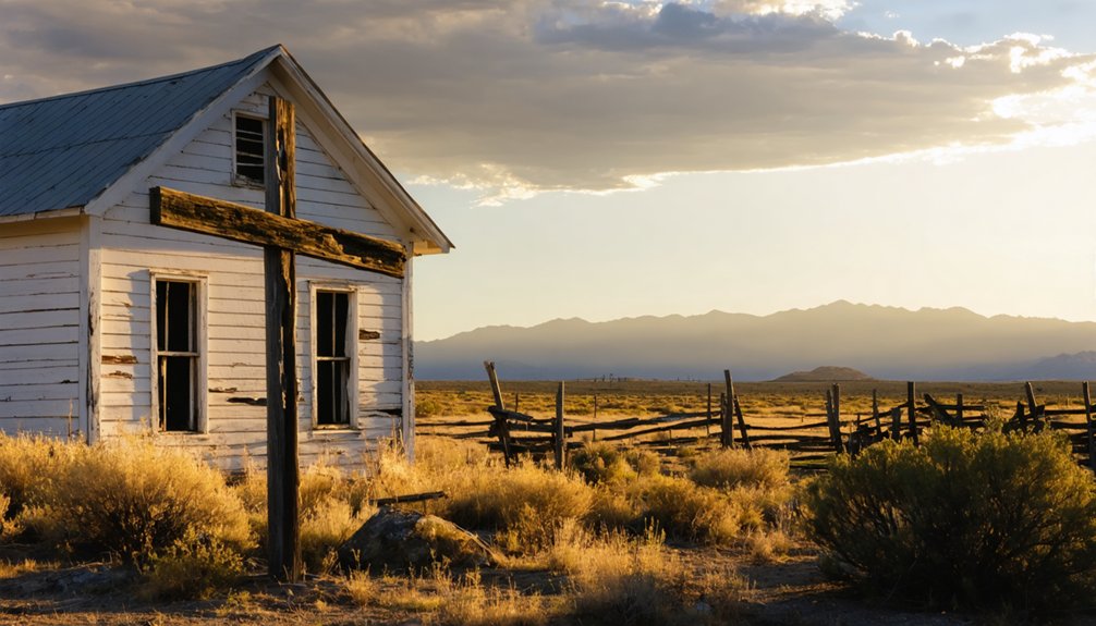
The centerpiece of Washakie’s architectural heritage stands in the 1939 LDS Ward Chapel, a one-story brick structure that embodies both Colonial Revival style and the community’s Mormon-Shoshone identity.
You’ll find distinctive Colonial Revival features throughout the building, from its symmetrical multi-pane windows to the flared cornice created by corbeled brickwork.
The chapel’s exterior showcases common bond brickwork with header courses, while a gable roof intersects with a cross-gable to create a unique silhouette.
Inside, you’ll discover original stained wood trim, a central hallway, and multiple rooms that served both religious and community functions.
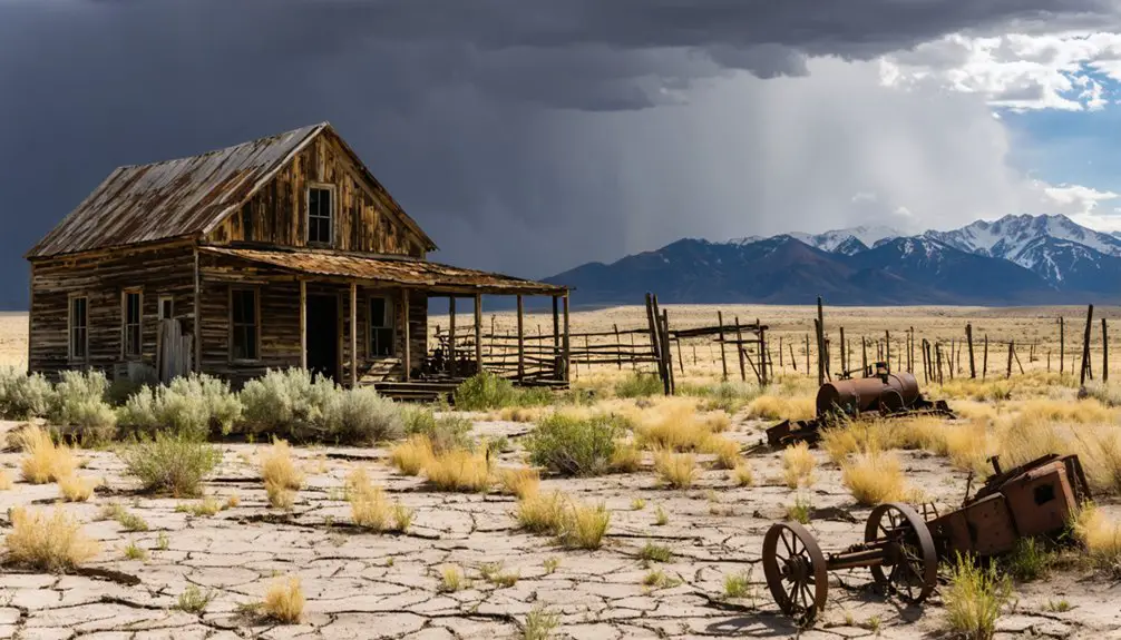
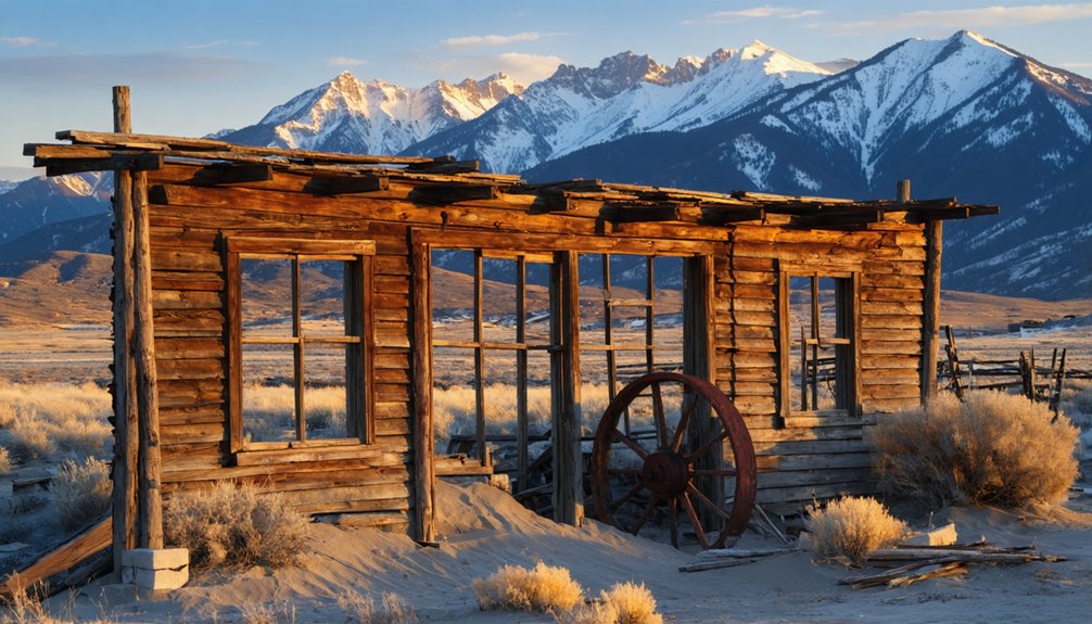
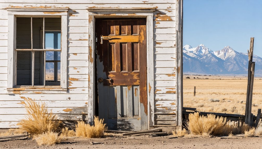
Though the town stands largely abandoned today, the chapel remains on the National Register of Historic Places as the most significant survivor of Washakie’s architectural legacy.
The Decline and Abandonment
Washakie’s decline began with a steady population exodus throughout the 20th century, accelerating significantly by the 1940s as residents sought better economic opportunities elsewhere.
You’ll find that diminishing church support, limited job prospects, and growing pressures for societal integration made it increasingly difficult for community members to sustain their isolated settlement.
The final blow came in the mid-1970s when the last residents departed, leaving behind the LDS chapel and altered schoolhouse as silent witnesses to the once-thriving Northwestern Shoshone community.
The historical significance of Watson Ghost Town extends beyond its physical remnants, reflecting the broader narrative of the American West and the impact of migration. Each structure tells a story of resilience and adaptation, showcasing the challenges faced by those who sought a new life in this rugged landscape. As time marches on, these echoes of the past serve as a reminder of a vibrant community that once called this place home.
Population Exodus Timeline
During the early 20th century, Native American residents maintained a stable community in Washakie, sustaining themselves through farming and ranching activities at the Washakie Indian Farm.
Cultural connections remained strong through the LDS chapel and tribal institutions until the post-World War II era.
You’ll find that migration patterns shifted dramatically in the 1960s when economic pressures and limited opportunities sparked an exodus from the settlement.
By the early 1970s, most residents had relocated to urban areas or other reservations seeking better prospects.
The closure of the LDS chapel and local school marked the final phase of depopulation.
Economic Factors Behind Closure
Several complex economic factors accelerated Washakie’s decline from a functioning settlement to an abandoned ghost town. The town’s economic monoculture, focused primarily on agriculture and tribal farming, left it vulnerable to environmental and market changes.
You’ll find that market isolation played a vital role – the remote location and poor transportation infrastructure made it difficult to access larger markets or attract new investment. When soil productivity declined and younger residents began leaving for better opportunities, the town’s fate was sealed.
- Limited natural resources meant no mining boom to sustain growth, unlike other Utah ghost towns that briefly thrived on mineral wealth.
- Transportation costs and infrastructure challenges made local businesses increasingly unprofitable.
- The exodus of working-age residents created labor shortages that crippled agricultural operations.
Community Resource Loss
The systematic loss of community resources in Washakie unfolded through interconnected waves of decline, beginning with demographic shifts and culminating in the dissolution of essential institutions.
You’ll find that poor resource management led to the dismantling of crucial community engagement points. The LDS Ward’s closure in the late 1960s stripped away religious infrastructure, while the sale of the Washakie Indian Farm to private interests devastated the tribe’s agricultural foundation.
The community’s physical landscape deteriorated as historic structures fell into disrepair. You can still see remnants of the once-thriving settlement in the surviving chapel, now listed on the National Register of Historic Places, and the cemetery that stands as a poignant reminder of tribal connections.
The loss of communal gathering spaces severely impacted cultural practices and traditional ways of life.
Preserving Historical Significance
Despite its status as a ghost town, Washakie maintains profound historical significance through various preservation efforts, most remarkably its LDS chapel’s listing on the National Register of Historic Places.
You’ll find dedicated cultural preservation initiatives focusing on the Washakie cemetery, where Northwestern Shoshone descendants actively maintain their ancestral ties. Historical documentation combines archaeological studies with tribal oral traditions, ensuring authentic representation of the site’s Indigenous heritage.
- The Washakie cemetery serves as an essential physical link to Shoshone ancestry, with tribal members actively protecting this sacred ground.
- Archaeological exhibits and painted elk hides by Chief Washakie’s descendants preserve critical cultural narratives.
- Public history events and educational programs help keep the story of Washakie alive, connecting modern audiences to this significant chapter in Native American history.
Modern Efforts for Cultural Reclamation
Modern efforts to reclaim Washakie’s cultural heritage center around ambitious land reacquisition initiatives by Northwestern Shoshone tribal leadership.
You’ll find their focus extends beyond the small tract containing Washakie cemetery, as they’re actively negotiating to expand their ancestral holdings through land restoration projects.
The tribe’s work includes adaptive reuse of historic structures, like the National Register-listed LDS chapel, while promoting community engagement through educational programs and cultural festivals.
You’ll see their dedication to tribal sovereignty reflected in agricultural practices that honor the Washakie Indian Farm legacy.
They’re fostering intergenerational knowledge transfer through collaborative partnerships with schools, museums, and government agencies, ensuring historical preservation while increasing public awareness of Shoshone traditions and identity.
Frequently Asked Questions
Are There Any Known Burial Sites Besides the Main Cemetery?
In 184 acres of documented land, you won’t find any additional burial sites beyond the main cemetery. Historical records, burial practices, and archaeological surveys haven’t revealed any hidden graves in the area.
What Natural Disasters or Severe Weather Events Affected Washakie’s Development?
You’ll find no major floods or droughts documented, though harsh winters forced seasonal migrations. Environmental challenges centered on alkaline water and irrigation issues rather than catastrophic weather events.
How Did Residents Earn Income Beyond Farming Activities?
Like rays of opportunity, you’d find income through cooperative stores, livestock trading, and timber harvesting. You could also tap into nearby mining operations and trade routes for additional revenue streams.
Were There Conflicts Between Washakie Residents and Neighboring Communities?
You’ll find evidence of land disputes and cultural tensions with neighboring Mormon settlements, though these weren’t as severe as earlier conflicts between Washakie’s band and white settlers or other tribes.
What Traditional Shoshone Ceremonies Were Practiced in Washakie?
Like sacred seeds planted in ancestral soil, you’d find Shoshone traditions of summer dances, pinyon harvest ceremonies, ritual feasts, and spiritual gatherings that connected people to Mother Earth through cultural significance.
References
- https://en.wikipedia.org/wiki/Washakie
- https://jacksonholehistory.org/learn/archives-research/chief-washakie-of-the-shoshone-a-photographic-essay-by-henry-e-stamm-iv-ph-d/
- https://kids.kiddle.co/Washakie
- https://eastern.usu.edu/prehistoric-museum/exhibits/archaeology/washakie
- https://www.rickjust.com/blog/chief-washakie
- https://www.yellowstonepark.com/park/history/chief-washakie-a-voice-for-the-people/
- https://www.britannica.com/biography/Washakie
- https://en.wikipedia.org/wiki/Malad_City
- https://welshsaints.byu.edu/Resource_Info.aspx?id=924
- https://www.boxeldercountyut.gov/533/Garland-History


