You’ll find Waterbury, a ghost town in Manatee County, Florida, at coordinates 27°26′44″N and 82°18′11″W. The town boomed during the 1920s phosphate mining era but declined rapidly during the Great Depression. Natural regrowth now obscures most remnants of this forgotten settlement, though you can still spot mid-20th-century structures like the Baldwin House and Jimmy Ellenburg House. The site’s hidden historical markers and artifacts tell a deeper story of Florida’s tumultuous land boom period.
Key Takeaways
- Waterbury, located in Manatee County, Florida, was abandoned after the 1920s Florida land boom collapsed and the Great Depression hit.
- The ghost town’s economy primarily depended on phosphate mining, and its depletion led to mass exodus of workers.
- Natural regrowth has overtaken the site, with few visible remnants except the original Waterbury Road and some mid-20th century structures.
- The town’s flat landscape features mixed hardwood forests and pine flatwoods, now home to diverse wildlife in absence of humans.
- Archaeological discoveries include mining artifacts, metal tags, hardware fittings, and personal items that chronicle the town’s industrial past.
Locating Waterbury’s Lost Community
Where exactly does one find the vanishing footprint of Waterbury?
You’ll discover this lost community deep within Manatee County at coordinates 27°26′44″N and 82°18′11″W. While community legends speak of a once-thriving settlement, today you’ll find little evidence of human habitation at this inland Florida location.
Unlike coastal ghost towns or river settlements that pepper local folklore, Waterbury sits isolated from major waterways and modern highways. You won’t find marked trails or historical markers guiding your way. Similar to the story of Hampton Springs Hotel, which burned down in 1954, Waterbury’s structures have largely disappeared from view.
The site’s remote positioning in southwestern Florida’s flatlands and mixed woodlands has left it largely forgotten. Natural regrowth has reclaimed much of what once stood here, though careful observers might spot buried foundations or scattered remnants beneath the subtropical vegetation. Like many ghost towns in Florida, it provides valuable insights into the state’s historical settlement patterns.
Historical Rise and Decline
You’ll find Waterbury’s trajectory follows a familiar pattern of Florida boom towns, experiencing rapid growth during the 1920s land boom through agriculture and basic commerce.
The town’s initial promise hinged on its strategic location for farming distribution, though its relative isolation from major transportation routes ultimately contributed to its vulnerability. Similar to how town by town, Osceola was systematically dismantled when economic prospects dried up. Like the record releases of the Robin Trower Band in 1974, the town’s activities peaked before beginning their decline.
When the Florida land boom collapsed and the Great Depression hit, Waterbury’s agriculture-based economy couldn’t sustain itself, leading residents to abandon their homes and businesses for more prosperous areas.
Settlement Patterns and Growth
During the early 1920s, Waterbury emerged as a modest settlement on Hunsader Farm land in Saint Johns County, Florida, though its development never reached the ambitious scope its founders envisioned.
Settlement challenges plagued the community from the start. You’ll find that despite early attempts to establish a viable town, Waterbury struggled to attract permanent residents. The area’s community dynamics reflected a transient population rather than a stable residential base, with nearby established towns drawing potential settlers away. Similar to Connecticut’s Little People’s Village, the area lost significant traffic after a new route was built. The Great Depression ultimately halted any further development plans.
The absence of essential infrastructure and public facilities further hindered growth. While historical maps show marked homesites and trails, the settlement’s population remained sparse.
Economic Factors Behind Abandonment
The economic downfall of Waterbury stemmed directly from its heavy reliance on phosphate mining in the 1920s. You’d have seen the town’s prosperity rise and fall with phosphate market prices, creating an unsustainable boom-bust cycle that ultimately proved fatal to its economic sustainability. Like many of the ghost town remnants across Florida, only scattered debris and foundations remain today.
As phosphate reserves depleted and mining yields declined, you’d have witnessed a mass exodus of workers seeking opportunities elsewhere. The town’s failure to achieve industrial diversification left it vulnerable when the mining operations became less profitable. Similar to how harsh conditions impacted New Ebenezer’s survival, Waterbury’s challenging environment took its toll on the community.
Supporting businesses soon collapsed as the population dwindled, creating a domino effect of closures. Regional economic shifts and poor infrastructure investment further isolated Waterbury, while competing towns with better resources drew away remaining residents and commerce.
Without alternative industries to sustain it, the town’s fate was sealed.
Transportation Changes Impact Community
While stagecoach routes served as Waterbury’s lifeline since the 1860s, connecting it to major Florida destinations like Palatka and Tampa, these essential transportation arteries began shifting dramatically by the late 19th century.
The transportation evolution brought by the Florida Southern Railway and Henry Plant System bypassed Waterbury, redirecting commerce and people away from the once-bustling stagecoach stop.
You’d have witnessed the town’s community resilience tested as up to 24 daily trains transformed regional mobility, making the old stagecoach infrastructure obsolete.
Similar to the situation in Kerr City, the devastating freezes of 1894-95 dealt the final blow, destroying citrus crops that had given purpose to local shipping routes.
Much like the Oriole mining company that operated from 1890 to 1915 in nearby Hernando County, the area’s industrial ventures struggled to sustain economic growth.
Without agricultural freight or regular passenger service, Waterbury’s transportation relevance faded, prompting residents to relocate toward thriving rail hubs.
Natural Landscape Today
Located in central Florida, Waterbury’s natural landscape exemplifies the region’s characteristic inland terrain through its flat topography and diverse ecosystems.
You’ll find mixed hardwood forests and pine flatwoods dominating the area, while natural succession has transformed former residential spaces into thriving wildlife habitats. Wetlands and marshy areas dot the landscape, fed by seasonal fluctuations in water levels.
The absence of human activity has allowed wildlife diversity to flourish, with deer, raccoons, and various bird species reclaiming the ghost town’s territory.
While sandy soils support native vegetation, you’ll notice some challenges emerging – invasive species threaten to establish themselves in disturbed areas, and unmanaged pine flatwoods face increased fire risks during dry seasons.
Former drainage ditches and irrigation systems have yielded to nature’s rhythms.
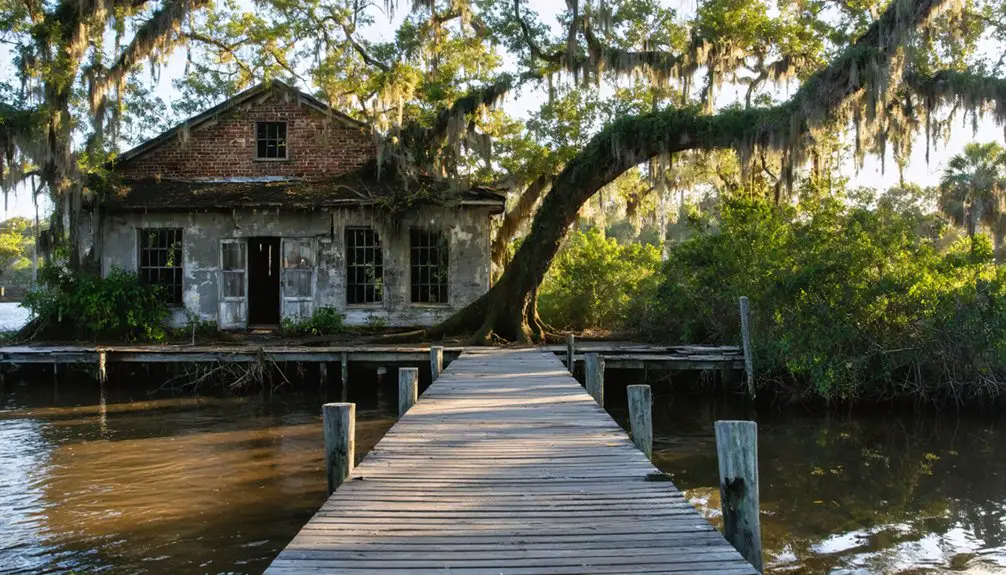
Notable Landmarks and Remnants

Today, you’ll find few traces of Waterbury’s ambitious past, as the ghost town lacks any substantial structural remains.
The original Waterbury Road serves as one of the only tangible connections to this failed pre-Depression development project.
While exploring the Hunsader Farm site between SR64 and SR70, you’ll notice the absence of building foundations or historical markers that typically characterize abandoned towns.
Old Building Foundations
The remnants of six main buildings stand as silent witnesses to Waterbury’s past, having survived Hurricane Andrew in 1992 and subsequent fires that ravaged the ghost town.
You’ll find various foundation types among these structures, including the Baldwin House, Jimmy Ellenburg House, Bay Chateau, Hicks House, A-Frame House, and the Powerboat Club, each showcasing mid-20th-century coastal architectural styles.
The foundations reveal a unique community built entirely over water, with concrete piers and stilts that once elevated homes above the tides.
These closely clustered remnants preserve the original street layout and lot arrangements, painting a picture of a tight-knit waterfront settlement.
Today, you’ll need a permit from the Stiltsville Trust to visit these weathered yet historically significant foundations, which serve as the last tangible links to Waterbury’s remarkable past.
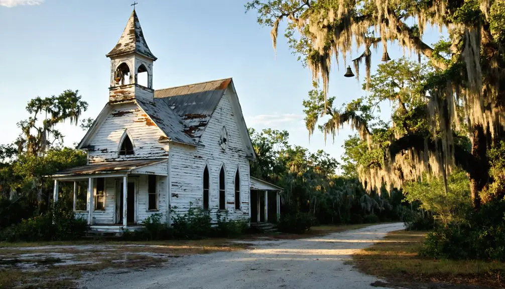
Hidden Historical Markers
Amidst Waterbury’s remnants, you’ll discover a wealth of hidden historical markers that chronicle the town’s rich past.
As you explore, you’ll encounter the Wells-Randall House‘s Greek Revival footprint, rebuilt in 2006 after a devastating fire. The Amasa Pride House, relocated in 1858, stands as a symbol of the town’s first merchant with its distinctive granite-framed entrance.
You’ll find hidden markers along Stowe Street, where the WDEV Block and Stimson & Graves Building reveal 19th-century commercial heritage.
Near James Church, approximately 800 feet from the town center, the Cemetery on Burying Ground Hill holds stone markers that silently narrate the stories of early settlers.
The 1875 Central Vermont Railroad Station‘s restored Italianate architecture marks the town’s crucial transportation history.
Exploring the Ghost Town Safely
When visiting Waterbury’s abandoned remnants, proper safety precautions and legal permissions remain essential for responsible exploration. You’ll need to secure access rights from landowners or authorities before venturing onto the property.
Pack essential safety gear including sturdy boots, protective clothing, and navigation tools. Group travel increases your security while exploring these remote locations.
Safety requires proper gear and group exploration – don’t venture solo into remote locations without sturdy boots and protective equipment.
Always carry water, first-aid supplies, and offline maps since cellular service can be unreliable. Time your visits during cooler hours and check weather forecasts to avoid dangerous conditions.
You’ll want to watch for wildlife hazards common to rural Florida, including snakes and insects. Remember to follow “Leave No Trace” principles and respect any posted boundaries or restrictions.
Document your planned route and share it with someone who can alert authorities if needed.
Archaeological Discoveries
Recent archaeological investigations at Waterbury have yielded significant artifacts that chronicle the town’s coal mining heritage. Through metal detecting and mudlarking along creek banks, you’ll discover relics that reveal the daily lives of those who once called this industrial town home.
The artifact significance stems from preserved items found beneath layers of sediment, painting a vivid picture of 19th and early 20th-century mining operations.
- Coal mining artifacts include metal tags, hardware fittings, and structural remnants from collapsed buildings.
- Personal items such as buckles, lighters, and porcelain doorknobs showcase domestic life.
- Community engagement through local metal detecting groups and youth participation helps preserve and document these historical finds.
These discoveries continue to enhance our understanding of Waterbury’s industrial past while fostering connection to local heritage.
Finding Waterbury’s exact location requires both historical and modern mapping resources.
You’ll need to navigate using coordinates of 27°26.7’N latitude and 82°18.2’W longitude in Manatee County, Florida.
Historical mapping techniques reveal Waterbury on 19th-century railroad and settlement maps, though navigation challenges arise from varying longitudinal references of that era.
To reach the site today, you can input the coordinates into GPS devices or mapping apps.
While Google Maps may not label Waterbury directly, you’ll find the location through GIS systems and topographic maps.
Consider consulting the Florida Memory Project or state GIS portals for historical overlay maps.
Remember that access may require landowner permission, as the ghost town sits on mixed forest and rural terrain.
Preservation Efforts

Ongoing preservation efforts at Waterbury focus on both legal protections and community-driven initiatives.
You’ll find state agencies working alongside local nonprofit organizations to implement preservation techniques that protect this historic site. The Florida Confederation for the Preservation of Historic Sites leads community involvement through volunteer programs and fundraising efforts.
State and nonprofit groups collaborate on preservation while the Florida Confederation spearheads local volunteer engagement and funding initiatives.
- Physical conservation includes stabilizing foundations, clearing invasive vegetation, and installing protective fencing.
- Archaeological surveys document artifact locations, old railroad grades, and remaining structural elements.
- Educational programs feature guided tours, public talks, and digital archives to share Waterbury’s history.
State regulations prohibit artifact removal, while local historical societies maintain detailed records of the site.
You’re encouraged to participate in organized preservation activities while respecting the site’s protected status for future generations to explore and study.
Photography and Documentation Tips
Whether you’re documenting Waterbury’s historic ruins or capturing its haunting atmosphere, proper photography techniques prove essential for preserving this ghost town’s visual legacy.
Start with wide-angle establishing shots to showcase the town’s scale, then move to intimate details that reveal its abandoned story. You’ll want to bring a sturdy tripod and flashlight for low-light interior shots.
Your storytelling methods should focus on creating narrative through composition. Shoot from varied angles, incorporate reflections, and capture architectural details that speak to Waterbury’s past.
For dramatic night photography, use long exposures to capture star trails, but avoid fire-based light painting that could damage historic structures.
Remember to obtain necessary permissions and respect posted restrictions while documenting this piece of Florida’s forgotten history.
Frequently Asked Questions
Are There Any Reported Paranormal Activities or Ghost Sightings in Waterbury?
You won’t find verified ghost encounters or spectral legends here – research shows no documented paranormal activity. Don’t confuse it with Connecticut’s Waterbury, which does have established supernatural reports.
What Indigenous Tribes Originally Inhabited the Waterbury Area Before Settlement?
A million moons ago, you’d have found the mighty Timucuan people dominating this land’s cultural heritage, with their tribal influence stretching from the Aucilla River through Florida’s northeast, farming and trading extensively.
Did Any Famous Historical Figures Ever Visit or Live in Waterbury?
You won’t find any famous visitors or historically significant figures living there, based on available archival records. There’s no documented evidence of any prominent individuals settling or passing through.
What Was the Peak Population of Waterbury During Its Most Prosperous Period?
You won’t find verified peak population numbers, as historic economy records don’t exist for this location. Population decline patterns in Florida ghost towns are documented, but Waterbury’s specific data remains unknown.
Were There Any Significant Natural Disasters That Contributed to Waterbury’s Abandonment?
You won’t find evidence of natural disasters contributing to Waterbury’s abandonment. Historical records don’t indicate any hurricanes, floods, or severe weather events directly causing the town’s decline.
References
- https://www.youtube.com/watch?v=3kz06h9k0YU
- https://pastmaps.com/explore/us/florida/saint-johns-county/waterbury/hiking-exploration
- https://pastmaps.com/explore/us/florida/saint-johns-county/waterbury/metal-detecting
- https://www.onlyinyourstate.com/nature/vermont/creepiest-hike-vt
- https://en.wikipedia.org/wiki/List_of_ghost_towns_in_Florida
- https://kellycodetectors.com/content/pdf/site_locator_books/FL.pdf
- https://www.wikiwand.com/en/articles/List_of_ghost_towns_in_Florida
- https://www.qu.edu/globalassets/global/media/qu/documents/student-life/handbook/graduate-student-handbook-2016-17.pdf
- https://en.wikipedia.org/wiki/Waterbury
- https://floridahistoryblog.com/topics/ghost-towns/