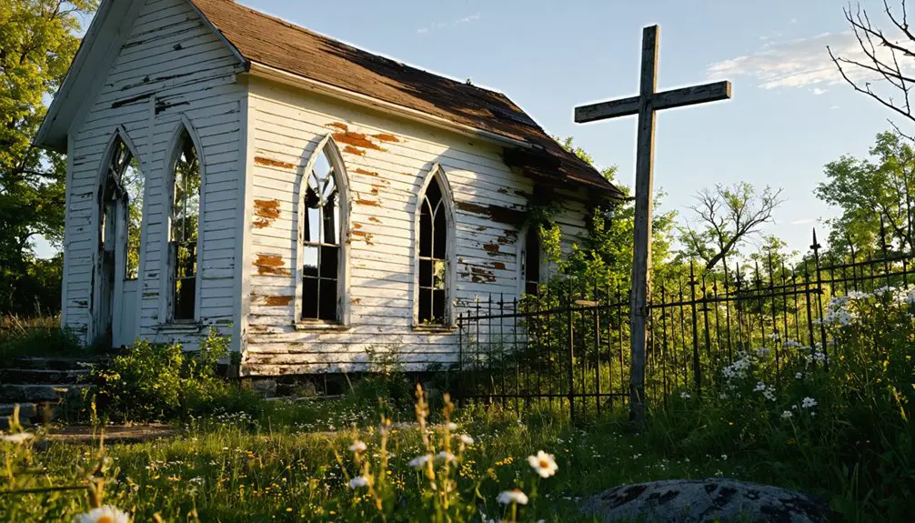
You’ll find Upper Waterford’s ghost town remnants scattered throughout Vermont’s dense northern hardwood forest. This once-thriving 1800s settlement met its end when residents sold their properties to New England Power Company for a Connecticut River dam project in the 1930s. While the original settlement vanished, stone walls, cellar holes, and old cemetery plots remain as silent witnesses. The area’s transformation continued in Lower Waterford, where a remarkable white-painted village would soon emerge.
Key Takeaways
- Waterford was abandoned in the 1930s when residents sold their properties to New England Power Company due to plans for a Connecticut River dam.
- The original settlement area transformed from farmland into dense forest, with stone walls and cellar holes remaining as historical evidence.
- Over 60 early residents lived in wooden homes with an agrarian lifestyle before the town’s deliberate abandonment.
- Nature reclaimed the abandoned farmland, though granite structures, cemetery plots, and farm road fragments remain visible through vegetation.
- Scattered cellar holes and weathered stone walls mark the locations of former homes and businesses around the old Main Street area.
The Rise and Fall of Upper Waterford
While Vermont’s landscape holds many ghost towns, few tell a story as compelling as Upper Waterford’s transformation from a thriving village to abandoned ruins. Established in the early 1800s, this settlement of over 60 residents exemplified Vermont’s rural character through its wooden homes and agrarian lifestyle.
Upper Waterford stands as a haunting testament to Vermont’s lost communities, its abandoned ruins echoing stories of rural life past.
The settlement dynamics of Upper Waterford centered around farming and local trades, with carriage roads connecting the village to surrounding communities. An old carriage road still remains visible today, connecting what was once Main Street to the outskirts of the former village. Notable structures like the Streeter Hotel once stood prominently along Bridge Street, serving as a center of community life.
You’ll find that economic challenges began emerging by the 1930s when residents learned of plans for a new Connecticut River dam. This news triggered a gradual exodus as families sold their properties to the New England Power Company, anticipating the inevitable flooding.
The village’s deliberate abandonment marked a poignant end to a once-vibrant community, leaving only memories and scattered ruins in Vermont’s forested hills.
Nature’s Reclamation: From Settlement to Forest
Since the abandonment of Upper Waterford, nature has steadily reclaimed the former settlement through a process of ecological succession.
You’ll find the forest ecology has transformed cleared farmland into a dense northern hardwood forest, where mature trees and thick underbrush now dominate the landscape.
As you explore the area, you’ll discover stone walls and cellar holes that persist as evidence of historical preservation, though most other signs of human habitation have vanished beneath the forest canopy.
The natural reclamation has restored native wildlife habitats and improved soil stability.
Similar to Ricker Mountain settlement, approximately 50 families once called this area home before abandoning it in the early 1900s.
Old cemetery plots and fragments of farm roads remain visible but muted by leaf litter and vegetation.
The abandoned settlement’s stone wall remains suggest the land was previously used for sheep farming in the early days of settlement.
This transformation represents nature’s resilient ability to heal and restore ecological balance, while still preserving glimpses of human history.
Hidden Traces: Stone Walls and Cellar Holes
If you wander through Waterford’s recovering forests today, you’ll find weathered stone walls stretching through the undergrowth, marking the boundaries of long-abandoned farms and fields.
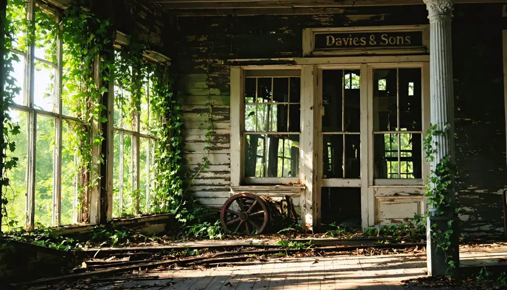
These granite structures, built by early settlers who laboriously cleared the land, stand as silent witnesses to the village’s agricultural past. Local historians note that Native American settlers first inhabited these grounds long before European colonization began. The area once bustled with activity around the Main Street establishments, including a blacksmith shop, store, post office, and Union church.
Alongside these walls, scattered cellar holes reveal the footprints of former homes and businesses, providing tangible evidence of the community that once thrived here before the power companies’ acquisitions led to its abandonment.
Stone Walls Tell Stories
The ancient stone walls threading through Vermont’s forests stand as silent witnesses to the state’s agricultural past. When you explore these stone boundaries today, you’re tracing the exact paths where 19th-century settlers transformed wilderness into farmland.
These walls tell complex stories of agricultural history, initially built by farmers clearing rocks from fields for plowing and later expanded during Vermont’s booming sheep industry. The annual frost heaves continually pushed new stones to the surface, requiring farmers to maintain and rebuild their walls each year. By the late 1800s, 70 percent deforested land dominated Vermont’s landscape due to intensive farming and logging practices.
You’ll find these walls vary in construction, from simple single rows to substantial double-row structures, reflecting the available labor and local geology.
Where you spot them alongside cellar holes, you’re looking at the footprint of vanished homesteads. In areas like the Champlain Valley, their absence reveals different geological stories – where glacial lakes left clay deposits instead of stone.
Forest Hides Settlement Remnants
Beneath Vermont’s dense forest canopy, a hidden world of settlement remnants lies waiting to be discovered.
You’ll find cellar holes and stone foundations concealed by layers of trees, moss, and leaf litter, creating a natural time capsule of hidden archaeology. These sunken depressions mark where homes once stood, their sizes revealing everything from modest cabins to larger homesteads.
Nature’s persistent growth both preserves and obscures these historical treasures. After the devastating mill fire of 1864, the land began its slow return to wilderness. The discovery of a rusted bed frame within one cellar hole offers tangible evidence of past inhabitants.
Tree roots and seasonal changes continuously reshape the landscape, while dense canopy shields these sites from casual observation.
Through careful forest preservation, you can still trace abandoned roads connecting these remnants, offering glimpses into vanished communities.
Each cellar hole tells a story of 18th and 19th-century life, quietly preserved beneath the protective embrace of Vermont’s old-growth forests.
The Birth of White Village
Located in Lower Waterford, Vermont, White Village emerged as a distinct community in the early 1900s during a period of significant regional change.
Exploring the history of West Waterford reveals a rich tapestry of cultural influences and economic transformations that shaped its development. The interplay between local traditions and outside innovations contributed to the unique identity of the area. As communities in the region navigated the challenges of a changing world, they laid the foundations for the vibrant society we see today.
While Upper Waterford faced decline due to an impending dam project on the Connecticut River, White Village experienced a remarkable transformation under John W. Davies‘ leadership after 1919.
You’ll find that Davies, a St. Johnsbury creamery owner, purchased most of Lower Waterford’s property and established the village’s signature appearance by painting buildings white with green shutters.
This distinctive aesthetic drew tourists and seasonal residents, shifting the community from its agricultural roots toward a summer destination.
The village’s evolution preserved its historic character while adapting to new economic opportunities, even as neighboring Upper Waterford’s residents sold their land to the New England Power Company in preparation for flooding.
John W. Davies’ Vision and Legacy
When you explore John W. Davies‘ vision for Lower Waterford, you’ll find his purchase of nearly the entire village marked the beginning of its transformation into the iconic “White Village.”
Through his wealth from successful dairy ventures, Davies established a unified white color scheme across the buildings and invested heavily in community structures like the Davies Memorial Library.
His lasting impact on Waterford’s architectural character and community spaces continues to define the village’s identity today, with preserved colonial buildings and maintained public facilities serving as reminders of his legacy.
Vision for White Village
John W. Davies transformed Lower Waterford into the iconic White Village through a distinctive vision of aesthetic unity.
You’ll recognize his influence in the uniform white-painted buildings with green shutters that define the village’s identity to this day. He purchased nearly the entire village in the early 20th century, implementing strict architectural guidelines that preserved its historical character.
Davies’ strategic vision extended beyond white aesthetics – he positioned the village as a prime summer destination while protecting it from regional modernization pressures.
His development supported essential community services, including the Davies Memorial Library, which houses the town office and post office.
Through his investments and preservation efforts, you can still experience the authentic charm of early 20th-century rural Vermont that Davies worked to maintain.
Restoration and Color Theme
Shortly after 1919, a transformative vision took hold in Lower Waterford as Davies purchased nearly the entire village and established its iconic white-and-green color scheme.
You’ll find his color preservation efforts created the distinctive “White Village,” which attracted tourists and defined the community’s visual identity for generations to come.
The restoration maintained architectural integrity through careful attention to early 19th-century Vermont vernacular features, including post and beam construction and box cornices with cornice returns.
Even after setbacks like the 1964 fire, adaptations preserved the historic character while accommodating modern needs.
The Rabbit Hill Inn exemplifies this legacy, evolving from a private residence to an elegant country inn while maintaining Davies’ signature palette.
His vision created a unified, photogenic environment that’s strengthened the village’s character and sustained its tourism appeal.
Lasting Community Impact
Through his remarkable acquisition and development initiatives, Davies forever changed Lower Waterford’s identity and economic trajectory in the years following 1919.
You’ll find his influence woven into every aspect of the village’s transformation, particularly through the economic revitalization that stemmed from his visionary leadership.
His lasting impact on the community is evident through:
- The iconic white-and-green color scheme that unified the village’s appearance and attracted tourism
- Establishment of the Rabbit Hill Inn as a cornerstone of local heritage
- Enhanced community cohesion through preserved architectural integrity
- Creation of a sustainable tourism economy that supported local businesses
Davies’ strategic development helped Lower Waterford weather economic uncertainties of the Great Depression while establishing a distinctive identity that continues to define the village today.
Early Settlers and Their Cultural Impact
During the early 1800s, family groups from northern Worcester County, Massachusetts, established the foundational settlement patterns of Waterford, Vermont. Notable families like the Cutlers, Bucks, Pikes, and Hastings bought land from early proprietors, consolidating holdings that would shape the community’s development.
You’ll find their settler traditions reflected in the Cape-style homes they built, evolving from simple log structures as their prosperity grew.
These families brought their New England cultural legacies with them, influencing everything from architectural choices to farming methods. They established private family cemeteries and maintained strong kinship networks, preserving their Massachusetts roots while adapting to Vermont life.
Through marriages and land transfers between prominent families, they created lasting social bonds that would define Waterford’s character for generations.
The Dam That Changed Everything
The construction of Moore Dam in 1954 marked a turning point that would permanently reshape Waterford’s landscape and community.
You’ll find that this massive dam construction project, completed in 1956 at a cost of $41 million, forever altered the Connecticut River’s flow and the region’s identity.
The reservoir impact was particularly dramatic, leading to these significant changes:
- The original village of Upper Waterford vanished beneath 73 billion gallons of water
- Pattenville disappeared completely under the newly formed reservoir
- Lower Waterford became the new town center, relocating essential community services
- The shoreline remained largely undeveloped due to fluctuating water levels
Today, you can witness New England’s largest hydroelectric facility in action, generating up to 192 megawatts of power while serving as a stark reminder of the sacrifices made for progress.
Architectural Heritage in Lower Waterford
While many Vermont communities lost their architectural character to modernization, Lower Waterford stands as a remarkably preserved example of 19th-century New England design.
You’ll find Greek Revival architecture dominating the landscape, from the 1859 Congregational Church to the historic Cutler House, with their distinctive box cornices, friezes, and pilasters.
The village’s architectural significance was further enhanced in 1919 when John W. Davies established the iconic “White Village” aesthetic, painting buildings white with green shutters.
This transformation shifted Lower Waterford from a farming community to a prestigious summer destination. Notable structures like the Rabbit Hill Inn demonstrate successful adaptive reuse while maintaining historical integrity.
Today, these buildings aren’t just preserved structures – they’re living representations of Vermont’s architectural heritage, featuring original clapboard siding, multi-stage steeples, and authentic period details.
From Ghost Town to Tourist Destination
As industries faded and populations shifted westward in the late 19th century, Waterford’s once-bustling community dwindled into near abandonment.
Today, you’ll find this ghost town transformed into a fascinating destination that draws history enthusiasts and adventurous travelers alike.
A forgotten settlement reborn, inviting curious wanderers to uncover its timeless stories and explore its mysterious past.
Historical preservation efforts have made Waterford accessible while maintaining its authentic charm.
Here’s what you’ll discover:
- Well-marked hiking trails following original carriage roads
- Protected foundational structures that tell stories of early Vermont life
- Educational signage highlighting the town’s industrial heritage
- Local businesses offering guided tours and historical interpretation
You’re free to explore this atmospheric settlement where nature meets history.
The site’s development as a tourist attraction has brought new life to the area, supporting nearby communities while preserving Vermont’s rich past for future generations.
Frequently Asked Questions
What Native American Tribes Originally Inhabited the Waterford Area?
You’ll find the Western Abenaki, particularly the Missisquoi band, held historical significance as the primary Native American inhabitants, maintaining continuous presence along the Connecticut River Valley for over 3,000 years.
How Many Residents Still Live in Upper Waterford Today?
You won’t find exact current population figures for Upper Waterford, as it’s not separately tracked in census data, though historical significance suggests it’s a small fraction of Waterford’s 1,301 total residents.
Were Any Artifacts Recovered Before the Dam Flooding Occurred?
Precious preserved artifacts primarily included relocated gravestones and an iron coffin. You’ll find historical significance in these cemetery monuments, though there’s no record of other archaeological items recovered before the flooding.
What Was the Population of Waterford at Its Peak?
You’ll find the highest population reached 1,412 around 1850, before abandoned structures began appearing and the town’s historical significance shifted. Recent peaks hit 1,295 in 2023, showing remarkable recovery.
Are There Guided Tours Available to Explore the Abandoned Settlement Sites?
You’ll find guided tours offering both walking and bus options, with specialty and paranormal experiences available. Local experts JoAnne and Heidi Longstreet can arrange historical insights through cemetery, museum, and property explorations.
References
- https://vermontcountry.com/2022/09/18/ghost-town/
- https://waterfordvt.gov/town-history.html
- https://waterford-vt-history.blogspot.com/2014/08/a-little-history-of-white-village.html
- https://outside.vermont.gov/agency/ACCD/ACCD_Web_Docs/_Drupal 7 ACCD Website Document Library/documents/Historic Preservation/6888 Route 18_Cutler House History Report.pdf
- https://www.youtube.com/watch?v=il-BaexRrRM
- https://www.instagram.com/reel/DBqvoTHO7Ck/
- https://www.instagram.com/reel/DBvug21xrZi/
- https://waterford-vt-history.blogspot.com/2011/11/village-of-upper-waterford-before.html
- https://www.onlyinyourstate.com/nature/vermont/creepiest-hike-vt
- https://obscurevermont.com/tag/ghost-town/


