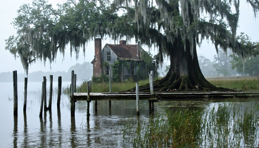
You’ll find Waterloo’s ghostly remains along Louisiana’s Mississippi River banks, where a bustling 19th-century trading post once thrived. The town’s early prosperity centered on river commerce and levee construction until the catastrophic 1884 flood destroyed its infrastructure and farmland. Survivors relocated to nearby New Roads, and arsonists later burned what remained. Today, only buried artifacts and local legends of outlaws, smugglers, and hidden treasures preserve Waterloo’s intriguing past.
Key Takeaways
- Waterloo was a riverside Louisiana settlement that became a ghost town after the devastating Mississippi River flood of 1884.
- The town’s infrastructure and agricultural lands were completely destroyed when local levees failed during the 1884 flood.
- Surviving residents relocated to the nearby town of New Roads, which offered better elevation and protection from future floods.
- Arsonists burned Waterloo’s remaining structures approximately a decade after the flood, eliminating all above-ground evidence.
- Only subsurface archaeological artifacts remain today, preserving evidence of the town’s history beneath the Mississippi River floodplain.
The Rise of a Mississippi River Trading Hub
As French traders ventured along the Mississippi River in the early 1700s, they established what would become one of America’s most essential trade corridors.
You’ll find that these early settlers weren’t just explorers – they were architects of significant trading routes that would shape America’s economic destiny.
When Fort Rosalie rose in 1716, it marked a turning point in river commerce. By 1718, New Orleans emerged as Louisiana’s capital, strategically positioned near the river’s mouth.
Fort Rosalie’s establishment and New Orleans’ founding transformed the Mississippi River into a vital artery of colonial commerce.
Early French pioneers like René-Robert Cavelier led expeditions that helped establish France’s claim to the Mississippi basin, forever changing the region’s future.
You can trace the evolution of trade through the early cargo shipments, like the impressive 15,000 bear and deer hides that made their way through Bayou Manchac to Lake Pontchartrain in 1705.
The Fox-Wisconsin Waterway soon connected the Great Lakes to the Mississippi, creating a vast network that would transform the region into a bustling commercial powerhouse.
The introduction of steam-powered boats revolutionized river transportation, reducing the journey from Louisville to New Orleans from four months to just twenty days by 1820.
Life Along the Levees
You’d have found the early residents of Waterloo engaged in constant levee maintenance, as landowners and laborers worked tirelessly to protect their riverfront settlement from the Mississippi’s fierce waters.
The community’s daily routines centered around watching for signs of levee weakness, with crews ready to respond at a moment’s notice using materials like timber, sand, and soil to reinforce vulnerable sections. Much of this grueling work fell to slaves and prisoners who endured harsh conditions maintaining the levee system. This work became even more critical as natural defenses eroded due to human activities in the region.
During high-water seasons, you’d have witnessed teams of workers patrolling the levees day and night, their lanterns swaying as they checked for seepage or early warning signs of potential breaks.
Levee Construction and Maintenance
While French colonizers first established levees in Louisiana during 1717, the history of flood control along the Mississippi River spans centuries of evolving engineering and local responsibility.
Early levee engineering focused on simple trapezoidal designs, with settlers building structures just 2-3 feet high along riverbanks.
Key developments in flood prevention included:
- 1819: Mississippi’s first official levee commission formed to oversee construction
- 1858: Creation of statewide levee district to coordinate efforts
- 1928: U.S. Army Corps of Engineers took control after devastating 1927 flood
You’ll find evidence of this engineering evolution in Waterloo’s remnants, where local landowners once maintained their own levees under state mandate.
Modern designs now incorporate floodways and backwater areas, with structures built to withstand 500-1000-year flood events.
Today’s comprehensive system includes 1,000 miles of levees protecting communities on both sides of the Mississippi River.
The Ransdell-Humphreys Act of 1917 marked the first federal legislation dedicated to flood control, promoting stronger levees and revetments.
Daily Riverfront Community Activities
Beyond the engineering feats of Waterloo’s levee system lay a vibrant community life that shaped daily existence along the Mississippi River.
You’d find locals gathering for guided swamp tours to spot alligators and egrets, while fishing enthusiasts cast their lines for redfish and speckled trout in both brackish and freshwater spots.
The waterfront buzzed with activity as families enjoyed picnics on sandbars and children splashed in spray parks near the riverbank. Honey Island Swamp tours became a beloved tradition for both residents and visitors seeking educational insights into the local ecosystem.
Community gatherings flourished through open mic nights at venues like Le Chien Brewing Company, while seasonal festivals celebrated local culture with live music and regional cuisine. The Christmas on the Bayou parade drew crowds each December as decorated boats illuminated the waterways.
River activities weren’t just recreation – they were the heartbeat of Waterloo, connecting people through shared experiences along these historic waters.
Natural Disasters and Town Destruction
You’ll find that Waterloo’s demise began with the catastrophic 1884 Mississippi River flood, which breached both the state-maintained and local levees protecting the cotton and sugar cane export center.
The floodwaters devastated the town’s infrastructure and agricultural lands, prompting most survivors to abandon their homes for the safer parish seat of New Roads. Like Napoleon’s famous defeat at Waterloo, the Louisiana town’s destruction marked the definitive end of an era.
A decade later, arsonists sealed Waterloo’s fate by burning what remained of the flood-damaged structures, effectively erasing the town’s physical presence from the landscape. Modern-day excavation work in the current subdivisions occasionally unearths artifacts and structural remnants of the once-thriving town.
Major Flood of 1884
As rising waters from the Ohio River surged southward in February 1884, Waterloo, Louisiana faced an unprecedented flood that would ultimately seal its fate.
The once-thriving port town, established in 1820, couldn’t withstand the devastating impact when multiple private levees failed along the Mississippi River.
The flood’s historical significance becomes clear when you consider these crucial impacts:
- Complete destruction of Waterloo’s essential sugar cane and cotton export operations
- Widespread displacement of residents who’d never return, transforming the town into a ghost community
- Long-term environmental damage that left fertile farmlands saturated and useless
Flood recovery proved impossible as the waters receded, leaving behind stagnant pools and debris where prosperous plantations once stood.
You can still find traces of Waterloo’s existence, though the town never recovered from this catastrophic event.
Impact on Local Levees
While local levees initially protected Waterloo from Mississippi River flooding, their structural limitations and mismanaged maintenance ultimately contributed to the town’s demise.
The levee system’s three-foot height proved inadequate for flood prevention, and its design focused more on navigation than safeguarding the settlement. You’ll find that continuous levees actually worsened Waterloo’s levee vulnerability by preventing natural overflow onto floodplains, which increased water pressure against the town’s defenses.
The situation deteriorated further when Congressional policies favored larger levee districts, leaving Waterloo’s smaller embankments neglected.
The 1917 Flood Control Act‘s local maintenance requirements strained the town’s resources, while downstream levee demolitions in 1927 raised upstream water pressure.
Erosion and repeated flooding cycles progressively weakened these essential protective barriers, sealing Waterloo’s fate.
Final Fire Damage
Following the devastating 1884 flood that broke Waterloo’s levees, a series of arson attacks in the mid-1890s delivered the final blow to this struggling riverside settlement.
The final fire impact was absolute, destroying what little remained of the town’s infrastructure after the flood damage. You’ll find no original buildings standing today, as arson aftermath transformed Waterloo into a true ghost town.
Here’s what sealed Waterloo’s fate:
- Multiple fires systematically burned entire sections of the town
- Arsonists struck when most residents had already relocated to nearby New Roads
- The destruction was so complete that only subsurface artifacts remain
Today, modern subdivisions occupy Waterloo’s former location, preserving only its street names as silent testimony to the once-thriving community that disappeared in flames.
Relocation to New Roads

The devastating Mississippi River flood of 1884 sparked a mass exodus from Waterloo to the nearby town of New Roads, located safely along False River.
You’ll find that this relocation demonstrated remarkable community resilience, as families strategically chose New Roads for its elevation and economic potential. The town, established in 1822 at the end of “Chemin Neuf,” offered protection from the frequent flooding that had plagued Waterloo.
As you explore New Roads today, you’ll notice how the cultural heritage of Waterloo lives on through street names and neighborhood identities.
The town’s evolution from a modest settlement to a diverse economic center reflects the wisdom of those early settlers who recognized its advantages. The shift preserved the area’s Creole plantation culture while allowing residents to adapt to changing environmental challenges.
Archaeological Discoveries and Modern Development
Archaeological surveys near Waterloo have revealed fascinating layers of history beneath the Mississippi River floodplain. The site’s archaeological significance spans thousands of years, with artifacts ranging from Plainview to San Patrice periods uncovered during pipeline surveys by CEI.
Modern geoarchaeological techniques have helped researchers identify:
- Multiple occupation phases through precise radiocarbon dating of plant seeds
- Prehistoric cultural activities linked to nearby mound sites dating back 11,000 years
- Evidence of indigenous ceremonial practices, including burned reed layers and charred bones
Today, you’ll find preservation challenges at Waterloo’s historic location, as modern construction overlays much of the ghost town’s remains.
Despite these obstacles, ongoing archaeological work continues to piece together the rich tapestry of human activity that once thrived along this stretch of the Mississippi River.
Tales of Outlaws and Hidden Treasures

During its heyday, Waterloo’s strategic location near the Sabine River made it a notorious haven for outlaws and smugglers in 19th century Louisiana.
You’ll find outlaw legends centered around infamous figures like John A. Murrell and his gang, who terrorized the region through horse theft and slave stealing. The Yocum gang operated a treacherous boarding house near Niblett’s Bluff ferry, preying on unsuspecting travelers.
Local treasure hunting enthusiasts still search for Hiram Midkiff’s buried gold, reportedly hidden along a creek north of Fisher. The dense woods and riverbed around Waterloo might conceal countless stolen fortunes, as outlaws frequently lost their loot while crossing the swift Sabine current.
While no official records confirm any recoveries, these tales persist as haunting reminders of Waterloo’s lawless past.
Legacy in Modern Street Names
Modern subdivisions near the original Waterloo ghost town site preserve its memory through carefully chosen street names, carrying forward a piece of Louisiana’s vanished history.
The history of Morrisonville, Louisiana includes not only its ghostly past but also tales of its early settlers who shaped the area. Each story adds depth to the landscape, enriching the community’s connection to its roots. As residents explore their surroundings, they uncover layers of tradition that continue to influence their way of life today.
The history of Taft, Louisiana, offers a glimpse into the lives of those who once thrived in this vibrant community. From the rich agricultural traditions to the influence of the Mississippi River, the stories of Taft illuminate the resilience of its residents. As new generations emerge, they carry forward the legacy of their ancestors, ensuring that the essence of Taft remains intertwined with their daily lives.
You’ll find this historical significance reflected in approximately 144 households built where the old town once stood, with street names that connect residents to their local heritage.
The area’s community identity remains strong through:
- Street names that commemorate not just Waterloo, but other ghost towns like Anchor and Cook’s Landing
- Physical remnants occasionally unearthed during property excavations
- Cultural connections maintained through naming practices that span from 1968 to 2007
Today’s middle-income neighborhoods, while demographically different from the original settlement, keep Waterloo’s memory alive through these intentional naming choices that bridge past and present.
Frequently Asked Questions
What Was the Average Property Value of Homes in Waterloo Before Abandonment?
Like scattered leaves in autumn, your search for precise average home values remains uncertain, though historical property trends suggest residences likely ranged from $20,000 to $70,000 before abandonment.
Did Any Notable Political Figures or Celebrities Ever Visit Waterloo?
You won’t find any records of famous visitors or political figures in this town’s history. The settlement lacked political significance and wasn’t known to attract celebrities before its 1884 destruction.
What Types of Shops and Businesses Operated in Waterloo’s Commercial District?
Among wooden storefronts and busy wharves, you’d find sugar processing facilities, cotton warehouses, general stores, taverns, blacksmith shops, apothecaries, and small banks serving the bustling river trade community’s needs.
Were There Any Schools or Churches Established in Waterloo?
You won’t find documented school history or church significance in the records – no evidence confirms their existence. The 1884 flood and later arson destroyed any traces that might’ve existed.
What Was the Total Population of Waterloo at Its Peak?
You won’t find a definitive peak population count in historical records, though Waterloo’s historical significance as a river trading post suggests it likely housed several hundred residents before its population decline.
References
- https://en.wikipedia.org/wiki/Waterloo
- https://www.louisianafolklife.org/LT/Articles_Essays/NSLeJeune3.html
- https://academickids.com/encyclopedia/index.php/Waterloo
- https://kids.kiddle.co/List_of_ghost_towns_in_Louisiana
- https://en.wikipedia.org/wiki/List_of_ghost_towns_in_Louisiana
- https://www.seekingmyroots.com/members/files/H007443.pdf
- https://710keel.com/discover-70-ghost-towns-from-across-louisiana/
- https://www.britannica.com/place/Mississippi-River/History-and-economy
- https://tammanyfamily.blogspot.com/2021/11/mississippi-river-history.html
- https://rosap.ntl.bts.gov/view/dot/67823/dot_67823_DS1.pdf