You’ll find Webster’s story uniquely compelling – a Kansas railroad town founded in 1876 that now lies 53 feet underwater. Originally home to 300 residents and 24 businesses along the Solomon River, Webster thrived until the 1950s when federal flood control efforts led to the construction of Webster Reservoir. The town relocated two miles southeast, leaving its original buildings, including the general store and schoolhouse, preserved beneath the waters. Webster’s sunken remains hold fascinating secrets of Kansas’s rural past.
Key Takeaways
- Original Webster town site was submerged under Webster Reservoir in the 1950s, with buildings now resting 53 feet underwater.
- Town was relocated two miles southeast of its original location during the reservoir’s construction in 1953-1956.
- Webster once thrived as a railroad community with 300 residents and 24 businesses by 1888.
- The underwater archaeological site includes preserved structures like the Webster Cash general store and village schoolhouse.
- Webster’s transformation from active town to submerged site exemplifies mid-20th century water management impacts on rural communities.
A Tale of Two Towns: Webster and Belmont
While many Kansas towns emerged along rivers in the late 19th century, Webster and Belmont’s unique story began in 1876 when settlers established a trading post near the Solomon River.
The town origins trace back to a post office naming conflict – when “Belmont” was rejected due to duplication, settlers chose “Webster” in 1879.
You’ll find an interesting twist in their community development: surveyors mapped 48 acres as Webster in June 1885, with an additional 120 acres to the south designated as Belmont that September.
Main Street connected both settlements north-to-south, while Broadway divided them east-to-west.
Though they functioned as distinct communities with separate churches, businesses, and social venues, only Webster was officially filed in November 1885.
Neither town ever formally incorporated, yet they shared a symbiotic relationship serving local agricultural needs.
The area experienced remarkable growth as thirty-six new buildings were constructed during an economic boom in 1885.
Belmont thrived early on as a bustling community with a general store and meat market, offering essential services to local residents.
Life Along the Solomon River
As the Solomon River carved its path through the Smoky Hills region, settlers found fertile valleys and strategic locations for establishing communities like Webster.
You’ll find the river’s rich history stretching back to Native Americans who called it Nepaholla, while French explorers later named it after colonial official Edme Gatien de Salmon.
The river ecology shaped pioneer agriculture, with asymmetrical valleys featuring steep south walls and gentle north slopes perfect for farming. The area receives 22.57 inches of annual precipitation, supporting diverse agricultural activities.
You’re looking at a watershed that spans roughly 6,800 square miles, dotted with Pleistocene deposits and chalk formations.
The river’s importance grew with the establishment of Fort Solomon in the 1860s, and today you can trace its legacy through historic sites like Nicodemus, one of the first African-American settlements in Kansas.
The river’s two main branches unite in Mitchell County, creating a vital waterway that sustained early settlements and continues to influence the region’s development.
Rise of a Railroad Community
When the Central Branch of Union Pacific Railroad reached Cloud County in January 1878, Webster’s transformation from a riverside settlement to a bustling railroad hub began.
The railroad’s impact peaked in 1885 as construction pushed west along the Solomon River, triggering remarkable community growth. You’d have witnessed Webster’s explosive development in 1886, with 36 new buildings rising from the prairie soil, supported by lumber hauled 60 miles from Hays. Similar to the Southern Kansas Railway, the line played a vital role in developing regional transportation networks.
By 1888, Webster had become a vibrant community of 300 residents, complete with 24 businesses, doctors, churches, and schools. The railroad brought essential connections – mail service, passenger transport, and commercial opportunities. Like the Tuxedo Park Station in Missouri, Webster’s depot served as a vital transportation hub for middle-class commuters and commerce.
While the rail line’s terminus at Stockton ultimately limited Webster’s expansion, this era marked the town’s golden age of progress.
The Making of Webster Reservoir
The devastating flood of 1951 sparked federal action to protect the Solomon River Valley, leading to Webster Reservoir’s authorization under the Pick-Sloan Missouri Basin Program.
You’ll find this massive earthen dam project faced significant construction challenges from its 1953 groundbreaking through completion in 1956, including weather delays and contractor issues while moving millions of cubic yards of earth. A key feature was its impressive 154-foot height that would help control flooding in the region. Like other place name disambiguation cases, multiple locations shared the Webster name during this period.
The project’s most dramatic impact came through community relocation, as the original town of Webster had to move about two miles southeast.
Here’s what happened to the town:
- Many businesses and residents chose not to relocate
- The high school’s final graduation occurred in 1954
- Original buildings were demolished as the reservoir basin filled
The completed dam transformed the landscape, storing 415,000 acre-feet of water for flood control and irrigation.
Legacy Beneath the Waters
Beneath Webster Reservoir‘s calm waters lies a perfectly preserved slice of Kansas history, with the original town’s buildings resting approximately 53 feet below the surface.
You’ll find the Webster Cash general store, a limestone hotel, and the village schoolhouse – all intentionally submerged rather than gradually abandoned. This underwater archaeology site spans 8,000 acres across Rooks and Osborne Counties, marking a profound community sacrifice for regional irrigation needs.
Much like the declining railroad towns near Bloom, Kansas, Webster’s flooding represents a broader pattern of mid-20th-century water management projects. The area’s transformation mirrors towns like Mount Casino, which was similarly abandoned due to external pressures.
While you can’t directly access these submerged structures today, they’re documented in local and federal records, serving as silent witnesses to an era when small farming communities gave way to large-scale infrastructure development.
Webster’s Place in Kansas History
Originally established in 1876 as a trading post combining two settlements along the South Fork Solomon River, Webster emerged as an essential frontier community during Kansas’s territorial expansion.
The town exemplified typical settlement patterns of the era, with its growth tied to agricultural development and its strategic location near water resources.
You’ll find Webster’s story reflects broader themes in Kansas history:
- The town showcases how frontier communities adapted to serve local farming populations
- It demonstrates the impact of 20th-century infrastructure projects on rural settlements
- Its transformation from bustling trade center to submerged ghost town represents the changing priorities of American development
Webster’s legacy lives on beneath Webster Reservoir’s waters, standing as a reflection of the evolving landscape of Kansas’s rural communities and the price of progress.
Frequently Asked Questions
Were Any Human Remains Relocated Before the Town Was Flooded?
Like pages torn from history’s book, you won’t find clear records showing cemetery preservation efforts. While remains relocation was standard practice for Kansas reservoirs, Webster’s specific details remain shrouded in mystery.
What Happened to the Town’s Cemetery During the Reservoir Construction?
You’ll find that during reservoir construction, they carefully relocated the cemetery’s graves and markers to higher ground outside the future basin, protecting the remains before Webster Reservoir’s waters could impact the site.
Can Scuba Divers Explore the Underwater Ruins of Webster Today?
You can’t explore underwater ruins in Webster through scuba diving, as there’s no evidence of submerged structures or diving restrictions in place. The area lacks documented underwater exploration opportunities.
Did Any Original Webster Buildings Get Moved Before Flooding Began?
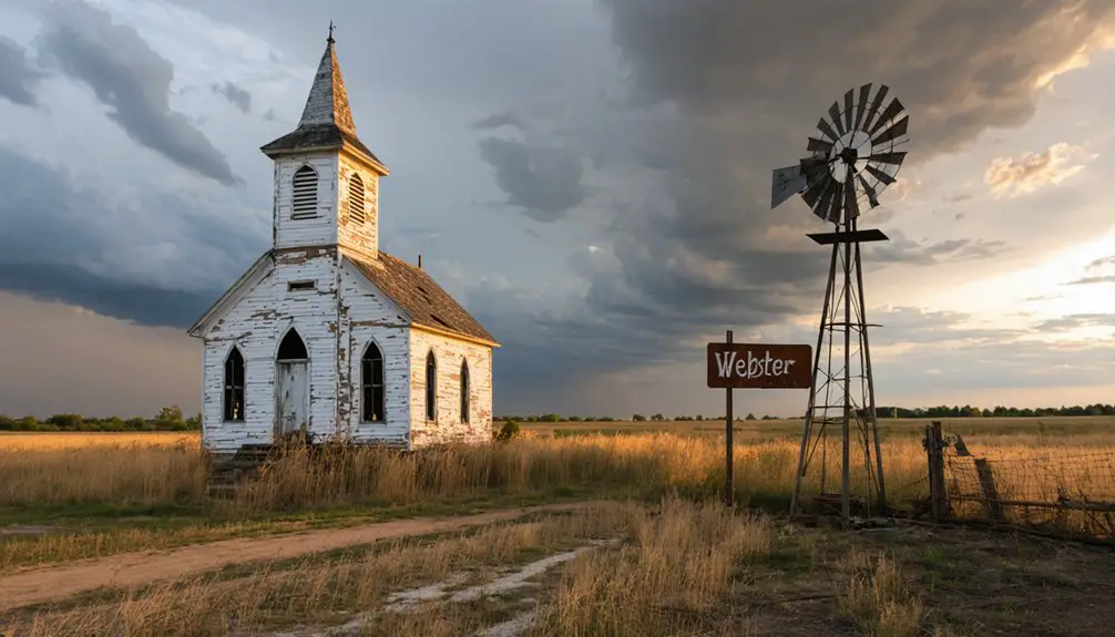
Yes, you’ll find numerous buildings were preserved through relocation, including the Methodist Church, a $186,000 school building, and about 30 other historically significant structures that were moved to Stockton and surrounding areas.
What Was Webster’s Peak Population Before Its Eventual Decline?
You’ll find historical population statistics showing Webster peaked between 200-300 residents during its most prosperous period, with the higher estimate’s historical significance backed by accounts of the town’s railroad-era growth.
References
- https://legendsofkansas.com/densmore-kansas/
- https://www.usbr.gov/projects/pdf.php?id=174
- https://www.youtube.com/watch?v=iB5rHT14eVI
- https://www.geotab.com/ghost-towns/
- http://www.hwy24.org/uploads/2/6/1/8/26189167/webster.pdf
- http://genealogytrails.com/kan/rooks/countyrecords_solomon_webster.html
- https://legendsofkansas.com/belmont-kansas/
- https://usgenealogyresearch.atwebpages.com/Kansas/Rooks/pioneers_of_western_kansas.pdf
- https://en.wikipedia.org/wiki/Webster
- https://legendsofkansas.com/solomon-river-kansas/


