You’ll find West Newbury tucked away along Tucker Mountain Road, where time seems frozen in the 1800s. This Vermont ghost town began in 1770 when pioneers cleared ancient forests to establish four founding farms. The 1833 Union Meeting House became the heart of this rural community, while Samuel Eastman’s 1841 store anchored its commercial life. Natural barriers and limited access preserved its 19th-century character, leaving a remarkable window into Vermont’s agricultural past.
Key Takeaways
- West Newbury’s isolation due to lack of river/rail access prevented commercial growth, preserving its 19th-century rural character.
- Natural barriers restricted development, confining the village to a narrow band of flat land southwest of the ridge.
- Former farmland has been reclaimed by dense hardwood and coniferous forest, with abandoned structures returning to nature.
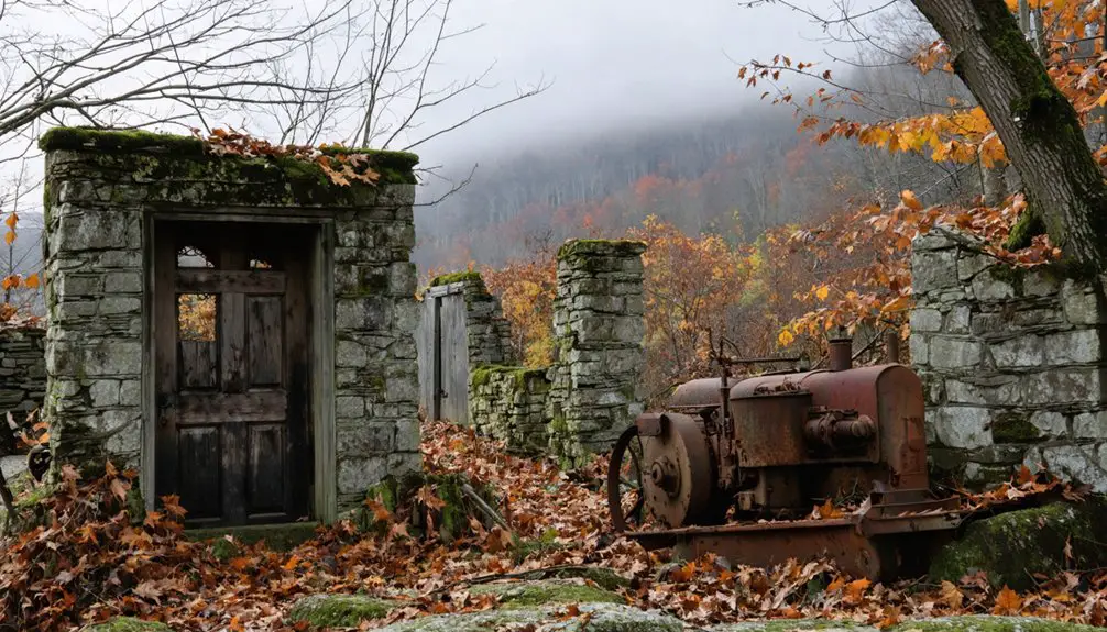
- The historic district contains 14 wood-frame buildings, including the 1894 schoolhouse and Samuel Eastman’s 1841 store-turned-apartments.
- The village center emerged around the 1833 Union Meeting House but remained a modest agricultural cluster due to limited transportation access.
The Forgotten Village of Kowasek
Although largely forgotten today, the village of Kowasek once stood amid Vermont’s dense Green Mountain forests near West Newbury. The Kowasek economy relied primarily on logging and charcoal production until natural resources became depleted.
You’ll find the settlement’s history mirrors many of Vermont’s rural ghost towns, where isolation and harsh conditions challenged survival. Like the town of Glastenbury, which supported a peak population of 241 in 1880, these mountain communities thrived briefly before declining. Heavy erosion and floods severely damaged the infrastructure, making it difficult to maintain vital connections with neighboring towns.
Despite the villagers’ efforts to maintain their community, Kowasek’s remote location and limited agricultural potential ultimately led to its downfall. As better opportunities emerged in surrounding areas, residents gradually departed their mountain home.
Now, the forest has reclaimed what was once a symbol of Vermont’s resource-based industries. You can still explore the remnants of this forgotten settlement, though only ruins remain to tell the tale of Kowasek’s history.
Early Colonial Settlement and Growth
You’ll find West Newbury’s colonial roots taking hold around 1770 when the first settlers cleared land in the back hill region of Newbury town.
Like their Massachusetts predecessors, these settlers faced conservation measures to protect the land and prevent erosion through careful grazing practices.
Before the American Revolution, four pioneering farms emerged, established by Samuel Hadley, Samuel Eaton, Josiah Rogers, and Kelley, who all chose the challenging terrain over the more popular river flats.
The physical village center wouldn’t materialize until much later, with the construction of the Union Meeting House in 1833 serving as a catalyst for the community’s growth. The village would later gain a vital commercial presence when Eastman’s store opened in 1841.
First Farms Before Revolution
When settlement began in West Newbury around 1770, ambitious pioneers like Samuel Hadley, Samuel Eaton, and Josiah Rogers ventured into the back hill region to establish the area’s first farms.
Unlike most settlers who preferred the valley intervales, these early homesteaders tackled the challenging task of clearing ancient forests with trees up to 450 years old.
You’ll find that settler agriculture took shape through Benjamin Whiting’s 1763 land division plan, which granted each proprietor three types of lots: riverside meadows, house plots along the main road, and fifty-acre parcels in the backwoods.
Despite the early challenges of frontier risks and territorial disputes, these determined farmers pushed deeper into the hills, following indigenous trails and establishing mixed farming operations that combined crop cultivation with livestock raising on the cleared uplands. Situated at 940 feet elevation, their farms offered commanding views of the surrounding landscape.
Those who initially built near the river were forced to move to higher ground due to frequent flooding of their homesteads.
Village Center Takes Shape
As West Newbury’s pioneering farmers pushed deeper into the forested hills in the 1770s, a distinct village center gradually began to take shape.
You’ll find that early settlers like Samuel Hadley, Samuel Eaton, Josiah Rogers, and Kelley established the first four farms, laying the groundwork for village governance and future growth. Like many colonial developments of the era, land disputes over Equivalent Lands created ongoing tensions among settlers and proprietors.
The construction of the Union Meeting House in 1833 marked a turning point, transforming the scattered settlement into a proper village center.
This crucial hub hosted both religious services and community gatherings, drawing residents together from across the agricultural landscape.
When Samuel Eastman opened his store in 1841 at the junction of Tyler Farm and Snake Roads, it cemented the village’s commercial core, though West Newbury’s isolation from major trade routes kept its development modest and primarily agricultural.
Agricultural Heritage and Rural Life
Despite its modest size, West Newbury’s agricultural legacy began around 1770 when ambitious pioneers like Samuel Hadley, Samuel Eaton, Josiah Rogers, and Kelley established farms in the hilly back region.
Pushing into West Newbury’s untamed hills, early settlers carved productive farmland from wilderness, building an enduring agricultural community.
Their farming traditions thrived on some of Orange County’s finest land, where dairy operations and sheep grazing demonstrated remarkable agricultural sustainability.
You’ll find evidence of ingenious adaptations in their farming practices, like the cemented spring enclosures used to cool milk overnight.
Local dairy farms, including John Tyler’s herd of 15-20 milk cows on Tucker Mountain, shaped the community’s character. The region’s farming heritage mirrors that of General Jacob Bayley, who established similar agricultural traditions in Newbury, Vermont.
The 1841 village store and local creamery supported these scattered farming operations, while the Union Meeting House served as the social heart of this close-knit agricultural community, binding together the families who worked this challenging but productive terrain.
Architectural Legacy: Buildings That Tell Stories
The architectural soul of West Newbury lives on through its historic district‘s 21 buildings, most dating from the 19th century.
You’ll find the Union Meeting House, built in 1833, commanding attention from its prominent incline as the village’s spiritual anchor.
The architectural storytelling continues through the district’s Greek Revival and Federal-style homes, where pattern books by Asher Benjamin influenced local builders. Early settlers received hybrid corn seeds from local Abenakis, enriching the agricultural practices that shaped the village’s development.
As you explore, you’ll discover preservation challenges haven’t diminished the authenticity of structures like the Smith-Kidder House with its distinctive cornice, or the two 1820s Cape Cod homes.
Each building, from the last surviving district schoolhouse to Samuel Eastman’s 1841 store, reveals West Newbury’s commitment to function over flamboyance, maintaining its rural character through conservative yet dignified design.
Geographic Isolation and Development Patterns
Nestled among protective hills at an elevation of 940 feet, West Newbury’s village layout reveals how geographic isolation shaped its destiny.
You’ll find the settlement patterns followed nature’s constraints, developing linearly along Tyler Farm Road from its junction with Snake Road.
The isolation effects were profound:
- Natural barriers restricted growth and preserved 19th-century rural character
- Lack of river or rail access prevented evolution into a commercial hub
- Limited road networks kept the village a modest agricultural cluster
When you explore West Newbury today, you’ll notice how the surrounding ridges and hills continue to define its development.
The village sits within a valley that’s dictated settlement possibilities, with the terrain naturally confining building to a narrow band of flatter land southwest of the ridge.
The challenging landscape echoes the region’s historical topography, where hills rise 800 feet above the river valley floor.
Historical Buildings and Their Modern Uses
Standing as evidence to Vermont’s rural heritage, West Newbury’s historic district showcases 14 wood-frame buildings that have adapted to modern needs while preserving their 19th-century character.
You’ll find the 1894 schoolhouse now serves as an educational heritage site maintained by the historical society, while Samuel Eastman’s 1841 store has transformed into apartments through adaptive reuse.
The district’s commitment to historic preservation shines through buildings like West Newbury Hall, which maintains its original late 19th-century structure, and the Eastman-Tyler House that still displays its distinct New England vernacular features.
Even newer additions, like the 1975 post office, were thoughtfully designed to complement the village’s historic aesthetic rather than disrupt it.
Native American Influence and Seed Legacy
Long before European settlers arrived in West Newbury, Indigenous peoples of the Wabanaki culture, including the Pawtucket and Pennacook, called this region home for thousands of years. Their cultural stewardship shaped the landscape through strategic agricultural practices and native pathways that connected valleys and hunting grounds.
The Wabanaki peoples cultivated and connected this land for millennia, weaving pathways between valleys long before colonial settlement began.
- Tucker Mountain Road follows ancient Indigenous travel routes, revealing their deep understanding of the terrain.
- The Connecticut River Valley served as prime ground for planting corn, beans, and squash, with seasonal villages like Koas (Coos) supporting these practices.
- Mission des Loupes near Newbury became a significant site for seed planting and cultural exchange.
Even after colonial conflicts disrupted traditional lifestyles, figures like Indian Joe of the St. Francis tribe maintained Indigenous connections to the land through continued seasonal planting and cultural practices.
Comparing West Newbury to Neighboring Villages
While West Newbury shares the town’s pastoral beauty with its neighboring villages, it has developed a distinct character from nearby Wells River and South Newbury. At 909 feet elevation, you’ll find West Newbury perched higher than its neighbors, offering sweeping vistas of the Connecticut River and distant mountains.
The West Newbury comparison to Wells River reveals striking differences. While Wells River bustles as a commercial hub with restaurants and shops, West Newbury maintains a quieter, residential atmosphere focused on community gatherings.
You’ll notice its large lots and ranch-style homes reflect its less dense population. Though both villages fall under Newbury’s jurisdiction, each has its own postal identity – West Newbury’s 05085 ZIP code distinguishing it from Wells River’s 05081, reflecting their separate roles within the town’s fabric.
Natural Landscape and Environmental Impact
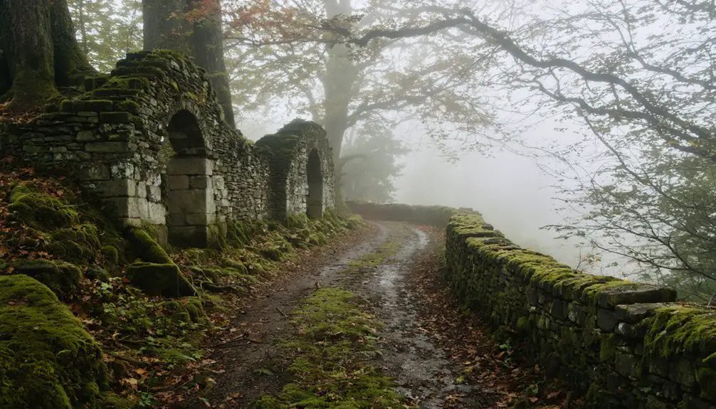
The ghost town’s tranquil setting extends beyond its architectural remnants into a flourishing natural ecosystem.
Abandoned structures stand silent as nature reclaims the land, transforming a forgotten settlement into a vibrant sanctuary of biodiversity.
You’ll witness how forest succession has transformed former farmland into dense hardwood and coniferous forest over 150 years. Nature’s reclamation has created essential wildlife corridors connecting the surrounding landscape.
- Dense tree canopy and understory plants now protect the soil, while vernal pools support breeding amphibians.
- Wetlands and streams maintain high water quality, with minimal human interference affecting natural water cycles.
- Stone walls and cellar holes blend into the recovering landscape, providing shelter for native wildlife like deer and black bear.
The Tucker Mountain area lets you explore these natural wonders while conservation efforts guarantee the delicate balance between public access and ecosystem protection remains intact.
Frequently Asked Questions
What Happened to West Newbury’s Original Population Over Time?
You’ll find population decline occurred steadily after 1850, with historical migration away from farming communities as residents sought industrial opportunities elsewhere, causing the area’s numbers to fall dramatically through the 1900s.
Are There Any Reported Hauntings or Supernatural Occurrences in West Newbury?
You won’t find documented ghost sightings or paranormal investigations in this area. Despite its historic character and indigenous roots, there’s no reliable evidence of supernatural activity in local records or folklore.
When Did the Last Business Permanently Close in West Newbury?
Like a fading heartbeat, you’d find the last business pulse stopped when the Eastman-Tyler Store transformed into apartments, marking the final business decline and community impact in the late 20th century.
What Transportation Routes Eventually Replaced the Historic Roads Through West Newbury?
You’ll find that major highways and rail lines bypassed the historic roads rather than replaced them. The transportation evolution favored other corridors, leaving these village routes to serve mainly local traffic.
Does Anyone Still Live in West Newbury Today?
You might think it’s a ghost town, but West Newbury’s current residents would disagree! The village remains an active part of Newbury town’s history, with people living there as part of the 2,372 population.
In fact, many locals love to share ghost stories from Newbury Center, where tales of spirits and mysterious happenings add a unique charm to the area. These narratives not only entertain but also strengthen the sense of community, as residents bond over shared experiences and the rich folklore of their surroundings. Visitors often come looking for a glimpse of the past, hoping to catch a whisper of the legends that have lingered through the years.
References
- https://en.wikipedia.org/wiki/West_Newbury_Village_Historic_District
- https://www.crjc.org/heritage/V16-192.htm
- https://happyvermont.com/2020/07/27/6-things-to-know-when-visiting-newbury-vermont/
- https://archive.org/stream/historyofnewbury00wellrich/historyofnewbury00wellrich_djvu.txt
- https://www.uvm.edu/~fbryan/Townscape color.pdf
- https://happyvermont.com/2014/10/23/glastenbury-ghost-town/
- https://www.youtube.com/watch?v=ScW-H7A8yL8
- https://www.arcadiapublishing.com/collections/images-of-america/imprint-arcadia-publishing?page=94&phcursor=eyJhbGciOiJIUzI1NiJ9.eyJzayI6InByb2R1Y3RfbGluZV9pdGVtc19jb3VudCIsInN2IjoyLCJkIjoiYiIsInVpZCI6MzczNTQ1MDU1MDMwMTYsImwiOjM1LCJvIjowLCJyIjoiQ0RQIiwidiI6MX0.EkWxMAf5WvciIcClImN_ZGZ768TC31o1hD0j8MO3CCk
- http://freepages.rootsweb.com/~gtusa/history/usa/vt.htm
- https://en.wikipedia.org/wiki/List_of_ghost_towns_in_Vermont


