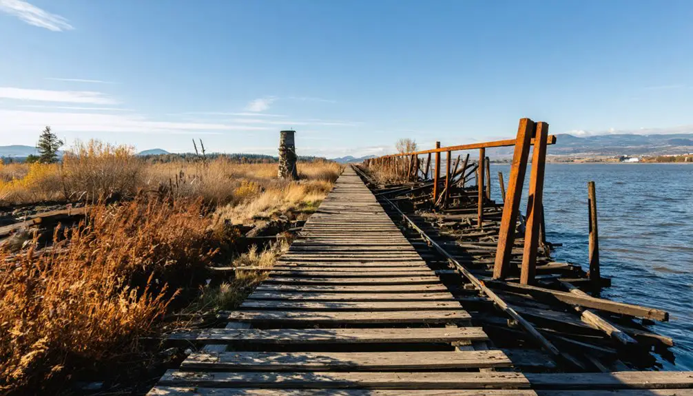
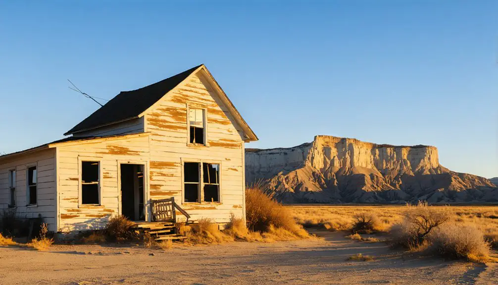
You’ll find White Bluffs’ remains along Washington’s Columbia River, where a vibrant farming community once thrived from 1861 to 1943. The town flourished with orchards, wheat fields, and an essential ferry crossing until the U.S. government abruptly seized 600 square miles for the top-secret Manhattan Project. Within 30-90 days, 1,500 residents were forced to abandon their homes, transforming this agricultural haven into a restricted ghost town whose untold stories still echo across the landscape.
Key Takeaways
- White Bluffs was a thriving agricultural community along the Columbia River until 1943, when residents were forcibly evacuated for the Manhattan Project.
- The town’s remains are now part of the Hanford Site, with abandoned buildings and foundations marking its former location.
- Before evacuation, White Bluffs supported orchards, vineyards, and wheat farms through extensive irrigation systems developed in the early 1900s.
- The government gave residents only 30-90 days to leave their homes, transforming the bustling community into a restricted military zone.
- Original structures were either demolished or repurposed for the Hanford nuclear facility, leaving behind a ghost town within the secured area.
The Settlement Years (1861-1943)
Before White Bluffs became a thriving settlement in 1861, the area served as home to the Wanapum Indians and hosted a Hudson’s Bay Company trading post established in 1826.
Long before settlers arrived in 1861, White Bluffs was home to Wanapum Indians and a Hudson’s Bay Company trading outpost.
Despite initial settlement challenges, the community quickly established itself as an essential transportation hub along the Columbia River, with a horse-powered ferry service helping miners reach gold fields across the region.
You’ll find that White Bluffs’ community development progressed steadily, expanding to both sides of the Columbia River by the 1890s.
The arrival of the railroad in 1913 prompted the town’s relocation to optimize transportation access.
The settlement flourished through agriculture, with farmers cultivating pears, apples, vegetables, and grapes for wine.
This agricultural foundation sustained White Bluffs until 1943, when the government seized the land for the Manhattan Project.
A state-sponsored colonization project for World War I veterans was attempted in 1921 but abandoned by 1925.
Residents were given between three days to months to evacuate their homes when the government acquired the land.
Agricultural Glory Days
While the early settlers of White Bluffs faced initial agricultural challenges, the establishment of the Hanford Irrigation and Power Company in 1906 transformed the arid landscape into fertile farmland.
The community’s agricultural practices flourished through innovative irrigation systems and electric pumps, demonstrating remarkable resilience in converting desert into productive soil. Ferry services connected White Bluffs to other riverside communities, facilitating trade and transportation of agricultural goods.
You’ll find these notable developments marked White Bluffs’ agricultural glory:
- Farmers acquired land at $40 per acre from Northern Pacific Railway, investing in irrigation projects.
- Wheat emerged as the dominant crop, sustaining Franklin County’s economic backbone.
- Orchards and vineyards thrived, producing commercial quantities of apples, pears, and wine grapes.
- Progressive farmers like Paul Bruggeman successfully integrated diverse operations, combining cattle ranching with fruit production.
This agricultural golden age continued until 1943, when the Manhattan Project forced the community’s evacuation.
Life Along the Columbia River
Along the Columbia River, White Bluffs emerged as an essential transportation hub in 1860 when its horse-powered ferry began connecting the river’s east and west banks.
You’d find the ferry’s unique design featured horses walking on treadmills to propel vessels across the water, charging passengers anywhere from ten cents for livestock to three dollars for wagon crossings.
River commerce flourished as steamboats linked White Bluffs to Portland by the late 1850s.
The town’s ferry history intertwined with regional trade networks, supporting gold miners heading to British Columbia, Idaho, and Montana.
White Bluffs Ferry became a vital lifeline for gold rush prospectors, connecting their dreams to the mining fields beyond.
You’d witness pack trains loading supplies, Hudson’s Bay Company fur traders conducting business, and farmers transporting their produce across the Columbia.
The ferry service transformed White Bluffs into a crucial crossing point, uniting communities and enabling trade until 1943, with the surrounding landscape dominated by the dramatic buff-colored bluffs that gave the town its name.
Native American Heritage and Loss
You’ll find deep historical significance in White Bluffs as the ancestral territory of the Wanapum people, who maintained permanent settlements along the Columbia River for countless generations before European arrival.
The location served as a vital river crossing point where the Wanapum, along with their Palouse, Yakama, and Nez Perce neighbors, gathered for trade and cultural ceremonies.
When the U.S. government seized the land in 1943 for the Manhattan Project, the Wanapum were forcibly relocated to Priest Rapids, severing their ancient connections to these sacred territories and traditional river-based way of life. The tribes were granted visitation rights only for activities like camping, hunting and fishing in their former homeland.
Sacred Ancestral Territories Lost
Before Euro-American settlement transformed the landscape in 1861, the White Bluffs region served as sacred ancestral territory for the Wanapum and other Plateau tribes, including the Palouse, Yakama, and Nez Perce peoples. Known as Nch’i-Wana (“Big River”), this culturally significant area sustained Indigenous communities for thousands of years through fishing, hunting, and gathering.
The sacred landscapes you’ll find here once supported:
- Traditional river crossings essential for inter-tribal trade and celebrations
- Ancient fishing grounds where tribes maintained sustainable practices
- Ceremonial gathering places that strengthened cultural bonds
- Archaeological sites containing Columbia River gem points
You’ll discover how government seizure in 1943 devastated these ancestral connections, forcing Indigenous peoples from their lands within 90 days and severely restricting their access to sacred sites that had defined their spiritual identity for generations.
Wanapum River Crossing Legacy
The sacred connection between the Wanapum people and the Columbia River extended far beyond mere physical sustenance, embodying a profound spiritual relationship that shaped their entire way of life.
At White Bluffs, you’ll find echoes of Wanapum traditions that once flourished along these shores, where the Nch’i-Wana (Big River) served as both lifeline and spiritual center. Living in traditional mat lodges, the Wanapum maintained an intimate relationship with the riverbank landscape. The teachings of their revered prophet emphasized wisdom through dreams rather than manual labor.
The river crossings here weren’t just physical passages but gateways to ceremonial grounds where Prophet Smohalla led sacred rituals that united the community through river spirituality.
You can trace the profound loss that occurred when dams flooded ancient village sites and ceremonial grounds, disrupting centuries-old fishing practices and religious ceremonies.
Despite these challenges, the Wanapum’s spiritual connection to these waters endures, even as their traditional crossing points lie submerged beneath the river’s surface.
The Government’s Manhattan Project Takeover
You’ll find that in early 1943, the U.S. government abruptly ordered approximately 1,500 residents of White Bluffs and surrounding communities to evacuate their homes within 30-90 days, using eminent domain powers to seize roughly 600 square miles of land.
The site’s selection as part of the Manhattan Project remained shrouded in secrecy, with the War Department deliberately concealing its atomic weapons development purpose from displaced residents and the public.
Your understanding of White Bluffs’ transformation into a ghost town deepens when you consider how the government rapidly demolished or repurposed community buildings, including the high school, theaters, and packing warehouses, to make way for what would become the massive Hanford nuclear facility. The displaced farmers were at least permitted to harvest their crops before the government took final possession of their lands.
Sudden Evacuation Orders Issued
On March 6, 1943, residents of White Bluffs and neighboring communities received abrupt federal notices ordering them to evacuate their homes within 30 days, marking the beginning of a massive displacement to make way for the top-secret Manhattan Project.
The evacuation impact devastated approximately 1,500 residents who’d built their lives in this thriving agricultural region.
Despite your community’s resilience, you would’ve witnessed:
- Federal surveyors and appraisers evaluating your property before official notices
- Court-sanctioned requisition plans already approved by February 23
- Inadequate compensation offers for your homes and farmlands
- Complete secrecy about the true purpose of your displacement
You weren’t alone – Indigenous peoples, including the Wanapum, Yakima, Umatilla, and Nez Perce, also lost access to their ancestral lands and traditional fishing grounds.
The land would later become a crucial site for producing plutonium for nuclear weapons, with up to 51,000 workers operating the facilities during peak production.
Secret Military Site Selection
Behind the sudden evacuation orders lay meticulous planning by Manhattan Project officials who’d carefully selected White Bluffs and its surrounding region for strategic military purposes.
You’ll find their military strategy focused on securing an expansive inland location far from vulnerable coastlines, with access to the Columbia River’s abundant water and hydroelectric power from nearby dams.
The site selection process prioritized White Bluffs’ isolation and sparse population, which helped maintain secrecy. Local residents were given ninety days to relocate with compensation based on government property appraisals.
You’d notice how the area’s flat, rocky terrain proved ideal for constructing plutonium production facilities, while existing railroad infrastructure supported logistics.
The government’s acquisition of 625 square miles created a secure perimeter where they’d space reactor facilities miles apart, transforming this once-peaceful farming community into a classified military installation of unprecedented scale.
Destruction of Local Community
When the Manhattan Project commandeered White Bluffs in 1943, the government’s swift takeover devastated a thriving agricultural community of 1,500 to 2,300 residents.
You’ll find that this once-vibrant town’s cultural heritage was erased as the military prioritized secrecy over community resilience.
- You’d just 28 to 90 days to abandon your homes, farms, and orchards with minimal explanation beyond vague “military necessity.”
- Your town’s infrastructure was dismantled, including the commercial store, fruit packing warehouses, railroad depot, church, high school, banks, and theater.
- You received inadequate compensation, leading to prolonged legal disputes that remained unsettled after World War II.
- Your community’s social fabric was permanently torn apart as families scattered, leaving behind generations of established farming traditions.
Preserving a Lost Community’s Memory

The preservation of White Bluffs’ history stands as a reflection of the power of collective memory, even after the community’s forced dissolution in 1943.
Through memory reclamation efforts, you’ll find government records, photographs, and oral histories documenting both settler and Native American experiences. The Department of Energy’s 2008 photo gallery and historical interviews capture the essence of this lost community.
Cultural storytelling continues through literature like “Nowhere to Remember” and educational initiatives by the Partnership for Arid Land Stewardship.
While most physical structures were demolished, the community’s spirit lives on through commemorative events, museum exhibits, and interpretive signage.
Despite restricted access to the original townsite within the Hanford nuclear boundary, digital archives and virtual resources guarantee White Bluffs’ legacy endures for future generations.
Frequently Asked Questions
What Happened to the Pets and Livestock During the 1943 Evacuation?
You’d have faced tough choices during the pet evacuation and livestock fate – either selling, relocating, or euthanizing your animals, as no official program existed to help preserve them during forced relocation.
Are There Any Surviving Residents of White Bluffs Still Alive Today?
You won’t find any documented living survivors from White Bluffs today. Historical records and local folklore suggest that anyone who experienced the 1943 evacuation would now be over 80 years old.
Was There Any Organized Resistance to the Government’s Seizure of Land?
While residents didn’t stage community protests, you’ll find their resistance focused on legal battles for land rights, with attorneys like Powell and Wiehl helping secure settlements up to double the government’s initial offers.
What Compensation Did Displaced Residents Receive for Their Properties?
You’d have received compensation based on pre-war property valuations, though payments were often delayed and inadequate. Resident compensation typically came as lump sums for land, buildings, and improvements you owned.
Did Any Buildings From White Bluffs Survive and Get Relocated Elsewhere?
You’ll find few architectural relics were successfully relocated, though the Commercial Hotel and Leggett Mercantile Store moved to White Bluffs’ west side before 1922, preserving these historic structures amid widespread demolition.
References
- https://en.wikipedia.org/wiki/White_Bluffs
- https://www.visittri-cities.com/heritage/town-of-white-bluffs/
- https://workbasedlearning.pnnl.gov/pals/resource/cards/whitebluffs.stm
- https://columbiabasinherald.com/news/2020/jan/24/lost-towns-a-look-at-the-area-that-became-home-to/
- https://tours.hanford.gov/historictours/
- https://www.evansoutdooradventures.com/columbia-river-hanford-reach-white-bluffs-north-south-march-2016/
- https://ahf.nuclearmuseum.org/ranger/tour-stop/white-bluffs/
- https://www.nps.gov/places/000/white-bluffs-ferry-landing.htm
- https://www.nps.gov/articles/000/hanford-downwinders-farming.htm
- https://www.historylink.org/file/5671