You’ll find Zyba’s remains in Sumner County, Kansas, where it emerged as a railroad town in 1887 along the Chicago, Rock Island & Pacific line near the Ninnescah River. The settlement peaked at 27 residents by 1910, sustained by agriculture and rail commerce. Though a devastating tornado that year marked the beginning of its decline, Zyba’s post office had already closed in 1906. The ghost town‘s story reveals much about Kansas frontier life and settlement patterns.
The history of zarah ghost town further illustrates the challenges faced by small settlements during turbulent times. Located just a few miles from Zyba, zarah experienced similar trials with its population dwindling due to economic hardships and natural disasters. Like many ghost towns in Kansas, its remnants serve as a testament to the struggles of early pioneers seeking a better life.
Key Takeaways
- Zyba was established in 1887 as a railroad town along the Chicago, Rock Island & Pacific Railroad in Sumner County, Kansas.
- The town’s peak population reached 27 residents in 1910, with its post office operating from 1887 until closure in 1906.
- A devastating tornado in 1910 severely damaged local infrastructure, contributing to the town’s eventual decline.
- Agricultural challenges, economic shifts, and improved transportation networks led to Zyba’s transformation into a ghost town.
- The town served as a significant railroad station connecting Wellington to northern Sumner County before its abandonment.
The Rise of a Small Kansas Settlement
When Kansas Territory opened for white settlement in 1854, pioneers pushed 40-50 miles inland from the Missouri border to establish new communities like Zyba.
You’ll find that settlement patterns reflected the ideological conflicts of the time, as free-state settlers sought distance from pro-slavery Missouri influences.
Near the Ninnescah River, Zyba emerged on lands previously inhabited by Kansa, Osage, and Pawnee tribes. The Indian Removal Act had forced these tribes to relocate in the 1830s. The location offered essential water resources and fertile plains suitable for farming. Like in Lawrence, settlers received rifles from Massachusetts to defend against pro-slavery forces.
You’d have seen early settlers forming squatter associations to govern community conduct before formal laws took effect.
The establishment of Zyba’s post office in 1887 marked its growth as a frontier community, serving local agricultural and trade needs while connecting settlers to the wider territory.
Life Along the Rock Island Railroad
The Rock Island Railroad’s arrival transformed life in Zyba and similar Kansas settlements during the late 1880s. As railroad expansion pushed southward from Kansas City through the territory, you’d find new opportunities emerging at every stop.
The line’s aggressive growth brought Zyba into a vast network stretching across Kansas, Oklahoma, and Texas, following historic routes like the Chisholm Trail. Building on its 1847 original charter, the railroad had evolved from a small Illinois line into a major transportation force across the Midwest.
The Rock Island’s expanding rail system wove frontier towns into a mighty commercial web, following cattle trails blazed by earlier pioneers.
You’d see the depot become the heart of community connections, where locals gathered to receive news, goods, and visitors from distant places. The Reid-Moore syndicate took control in 1901, leading to even greater expansion across the region. The railroad gave you reliable access to major markets in Wichita, Kansas City, and Fort Worth, making it possible to ship cattle and crops year-round.
Whether you were a farmer, rancher, or merchant, the Rock Island’s robust infrastructure, including its impressive bridges and trestles, kept your business moving forward.
Daily Life in Early Zyba
Life in early Zyba centered around its strategic location between the Ninnescah River and Rock Island Railroad tracks, where you’d find a close-knit community of farming families and railroad workers going about their daily routines.
You’d notice the post office serving as the heart of communication from 1887 to 1906, while local churches and schools provided gathering spaces for community events.
Trade practices often involved bartering goods and services among neighbors, with residents relying on nearby towns for specialized needs.
Social life revolved around informal entertainment like dances and church functions, creating strong bonds between families.
If you needed a blacksmith, carpenter, or other craftsman, you’d likely find them working near the railroad, serving both locals and travelers passing through this small but self-sufficient Kansas settlement.
Like State Line in Opolis, the community developed its unique identity through its geographic positioning and the character of its residents.
The town’s fate mirrored many others that experienced declining populations due to harsh weather conditions and reduced mining activity.
Agricultural Heritage and Commerce
You’ll find that Zyba’s agricultural commerce revolved around railroad-based grain transport systems that connected local farmers to broader markets.
The presence of small town communities mirrored the agricultural pattern seen in places like Bell Plane, where farming remained the economic mainstay.
Local cattle trade operations thrived as ranchers drove their herds to designated shipping points where they’d be loaded onto rail cars bound for Kansas City and beyond.
The town’s small-scale farm economy depended heavily on these transportation networks, which enabled both crop and livestock producers to participate in regional trade despite their rural location. Like many agricultural communities, Zyba experienced a gradual decline over decades as technological advances allowed fewer farmers to manage larger tracts of land.
Railroad-Based Grain Transport
Throughout Kansas’s agricultural development, railroad-based grain transport transformed Zyba and surrounding regions into crucial links in America’s breadbasket. You’d have seen the impact of early rail infrastructure like the Atchison, Topeka & Santa Fe Railroad, which opened north-south shipping routes in 1869, revolutionizing how local farmers moved their grain to market. Concrete storage silos replaced many wooden structures, offering improved safety and capacity for the growing grain trade.
The evolution of grain logistics centered on strategically placed elevators alongside the tracks. These structures, evolving from wooden buildings to concrete silos, enabled you to efficiently store and ship massive quantities of wheat, corn, sorghum, and soybeans. The state’s grain transport capabilities were showcased in 1931 when Kansas produced a record 240 million bushels of wheat that needed rail shipping.
Local Cattle Trade Operations
When Kansas cowtowns emerged alongside expanding railroads in the late 1850s, Zyba’s strategic location helped it tap into a massive cattle trade network that moved 27 million head from Texas northward.
You’d have seen the town transform as stockyard operations expanded, following Joseph McCoy’s successful Abilene model that began in 1867.
Like other Kansas towns along the Chisholm Trail, Zyba’s cattle trade brought economic importance through associated industries. Local stockyards grew rapidly as Chicago meatpackers invested in modern processing facilities.
You’d have found a bustling multicultural workforce, including African Americans and immigrants, working the yards and packing plants.
The Kansas Livestock Association protected ranchers’ interests by fighting unfair railroad rates and cattle theft, while helping secure important policy victories that shaped the state’s agricultural heritage.
Small-Scale Farm Economy
Three key elements defined Zyba’s small-scale farm economy in the early 1900s: family-operated homesteads, local mill operations, and seasonal trade networks.
You’d find typical homesteads spanning about 160 acres, where families grew staple crops like wheat, corn, and barley. Local mill operations, powered by diverted water sources, formed the backbone of crop processing and commerce.
Small farm viability depended on close-knit community trading, where you’d exchange produce and handmade goods with neighbors.
Agricultural innovation gradually shifted this dynamic, as hybrid seeds and mechanization favored larger operations. While these advancements increased productivity, they challenged smaller farms’ survival.
Seasonal harvest festivals and local markets couldn’t compete with the economies of scale that larger, mechanized farms achieved, ultimately transforming Zyba’s agricultural landscape.
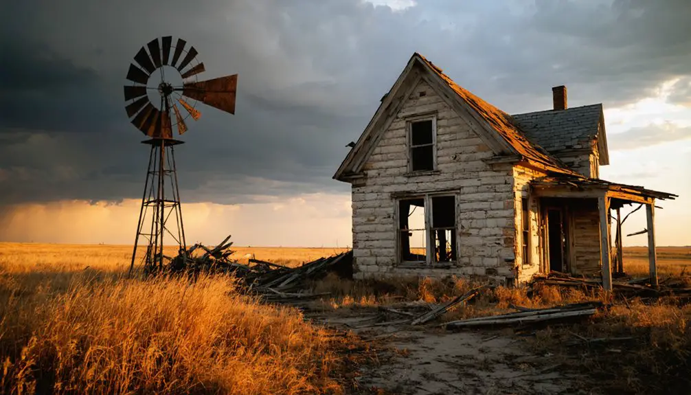
The Devastating Tornado of 1910
A devastating tornado struck Zyba and surrounding areas of Harvey County, Kansas, in the early morning hours of May 2, 1910. As you’d learn from the tornado aftermath, this near-cyclonic storm’s destructive force focused mainly on barns, windmills, and outbuildings while largely sparing homes.
The community’s resilience shone through as they faced widespread infrastructure damage but only one tragic fatality.
In the face of destruction, the people of Harvey County demonstrated remarkable strength, mourning one life while rebuilding their devastated community.
- The tornado hit around 1:00 a.m., catching many residents asleep
- Telephone and electric poles toppled, cutting off communications
- Trees were twisted and uprooted southwest to west of the area
- The storm’s violent noise terrified witnesses who documented the event
- Despite extensive structural damage, most homes remained standing
This historic tornado stands as one of Harvey County’s most significant early 20th-century natural disasters.
Natural Forces and Town Survival
You’ll find that Zyba’s struggle against tornadoes, particularly the devastating 1910 event, represented the precarious existence of early Kansas settlements.
Nature’s raw power exposed the vulnerability of rural communities, where limited emergency services and infrastructure made recovery especially challenging.
The combination of severe weather events and the town’s isolation ultimately proved too much for Zyba’s survival, reflecting a common pattern among Kansas ghost towns where natural forces overwhelmed human determination.
Tornado’s Devastating Impact
While many Kansas towns faced nature’s fury over the years, Zyba’s encounter with a powerful tornado marked a devastating turning point in its history.
The F4-F5 tornado’s immense power and wide path left little standing, destroying homes, farms, and critical infrastructure. Despite early tornado preparedness efforts, the community’s resilience couldn’t withstand nature’s assault.
- The tornado’s 2-mile-wide path obliterated most structures, leaving only a handful of buildings intact.
- Ground scouring stripped away topsoil and vegetation, making rebuilding nearly impossible.
- Multiple casualties overwhelmed local emergency response systems.
- The storm’s 40+ mph travel speed gave residents minimal warning time.
- Complete destruction of community institutions like schools and churches accelerated Zyba’s decline.
The catastrophic damage led to permanent displacement of residents, transforming Zyba into another Kansas ghost town.
exploring yocemento’s haunting history reveals tales of the lives once lived in its abandoned streets. As nature reclaims the area, remnants of the past serve as a poignant reminder of a community lost to time. Visitors are often drawn to the eerie beauty that now characterizes the town, where every crumbling building tells a story of resilience and regret.
Rural Life’s Fragile Balance
The fragile balance of rural life in Zyba reflected broader challenges facing Kansas farming communities in the mid-20th century. As agricultural mechanization advanced, you’d have seen fewer farmers managing larger tracts of land, while families who couldn’t compete moved away.
These rural sustainability challenges created a ripple effect – when farms consolidated, local businesses lost customers and closed their doors.
The town’s community resilience strategies couldn’t overcome the combined pressures of environmental stresses, economic shifts, and demographic changes. You’d find that as schools shuttered and medical services disappeared, remaining residents faced tough choices.
The semi-arid Great Plains climate made small-scale farming increasingly difficult, and without a stable agricultural base, Zyba’s social fabric began to unravel, accelerating its transformation into a ghost town.
Community Vs Mother Nature
Beyond the economic pressures that strained Zyba’s social fabric, natural forces dealt decisive blows to the town’s survival prospects. The community’s resilience was tested repeatedly by the untamed power of Kansas’ environmental challenges, particularly its position near the unpredictable Ninnescah River.
- Devastating tornados struck the region multiple times, destroying vital infrastructure.
- The river’s natural course changes threatened buildings and farmland.
- Severe storms exposed the town’s vulnerable geographic position.
- Mining-contaminated soil made large areas increasingly uninhabitable.
- Floods regularly threatened both homes and agricultural lands.
You’ll find these natural forces intersected with Zyba’s economic struggles, creating a perfect storm that overwhelmed the town’s ability to sustain itself.
While some communities might weather one or two environmental challenges, Zyba faced a relentless barrage that ultimately proved insurmountable.
Remnants of a Lost Community

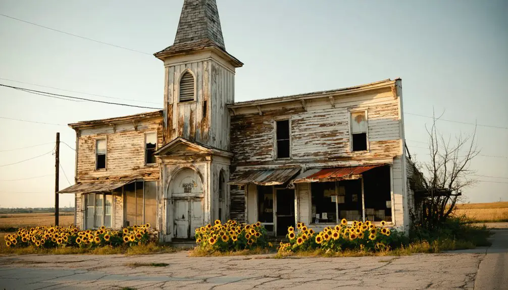
Standing as silent witnesses to Zyba’s past, scattered remnants offer glimpses into this former Kansas railroad community. You’ll find the 1947 church still commanding attention as one of the oldest identifiable structures, its adjacent cemetery preserving community memories through weathered headstones.
The railroad grade‘s ghostly outline cuts through the landscape, marking where trains once connected Zyba to the wider world.
While most homes have vanished, architectural remnants tell the story of a town that once housed 40 to 50 residents in the early 1900s.
Today, you’ll encounter occasional street signs among overgrown paths and abandoned rail infrastructure. The church stands as the most significant cultural marker, anchoring the few physical traces of this southern Kansas settlement that time has slowly reclaimed.
Historical Significance in Sumner County
Located 12 miles north of Wellington in Sumner County, Zyba emerged as a significant railroad station along the Chicago, Rock Island & Pacific Railroad line during the late 19th century.
The town’s strategic position near the Ninnescah River made it an essential link in the region’s railroad expansion, connecting agricultural communities to broader markets.
- Established a post office in 1887, serving as an important communication hub until 1906
- Reached a peak population of 27 residents by 1910
- Facilitated trade between Wellington and northern Sumner County communities
- Operated as an unincorporated settlement under county jurisdiction
- Connected local farmers to regional markets through postal services and rail transport
The town’s legacy represents the broader pattern of small railroad communities that shaped Kansas’s development, though it eventually succumbed to changing transportation patterns and economic shifts.
Legacy of the Ninnescah River Settlement
While the Ninnescah River settlement may have started as a modest frontier outpost in 1869, it quickly evolved into an essential economic corridor that shaped Sumner County’s development.
From humble frontier beginnings, the Ninnescah River settlement transformed into a vital economic force that defined Sumner County’s growth.
You’ll find the settlement dynamics were driven by natural advantages: limestone and sandstone deposits, salt springs, and fertile valley lands that attracted diverse settlers. The region’s resource management centered on trading posts, ranches, and farms, where well depths of 10-40 feet determined viable locations.
The area’s legacy lives on through the economic foundation built by pioneers like Charles Wichern and Thomas W. Boyle.
The convergence of the Chisholm Trail, salt trade, and agricultural ventures created a self-sustaining community. Early social institutions, including Presbyterian and Methodist congregations, established lasting community bonds that influenced subsequent settlement patterns throughout Kansas.
Frequently Asked Questions
Were There Any Deaths Reported During the 1910 Tornado in Zyba?
You’re chasing ghost stories! No deaths were documented from a 1910 tornado in Zyba. The tornado impact you’re thinking of actually occurred in 1915, when Zyba history recorded 3-4 fatalities.
What Native American Tribes Originally Inhabited the Zyba Area?
You’ll find the Kansa (Kaw) tribe dominated the tribal history around Zyba’s region, with cultural significance along the Kansas River, while Pawnee, Osage, and Comanche tribes periodically moved through the area.
How Did Zyba Get Its Unique Name?
You won’t find documented evidence of Zyba’s unique etymology or historical significance in naming records. The origin remains a mystery, possibly derived from early settlers or invented for postal recognition.
What Was the Average Land Price in Zyba During Its Peak?
While there’s no exact record, you’d likely have found land values in Zyba ranging from $5-20 per acre during its 1887-1906 peak, lower than nearby mining towns but boosted by railroad proximity.
Did Any Famous Historical Figures Ever Visit or Pass Through Zyba?
You won’t find any records of famous visitors passing through Zyba. The town’s limited historical significance and short-lived status as an active community make documented visits by notable figures highly unlikely.
References
- https://derbykshistorymuseum.org/blog/f/the-night-zyba-disappeared
- https://www.hhhistory.com/2019/05/ghost-towns-of-kansas.html
- https://www.youtube.com/watch?v=OyBXD18P_j4
- https://www.youtube.com/watch?v=ie3zwwHm2Jg
- https://en.wikipedia.org/wiki/Zyba
- https://legendsofkansas.com/first-kansas-settlements/
- https://civilwaronthewesternborder.org/blog/founding-lawrence-kansas
- https://www.rileycountyks.gov/441/History-of-Riley-County
- https://en.wikipedia.org/wiki/History_of_Kansas
- https://denversrailroads.com/Rock.htm


