You’ll find Alto ghost town high in Arizona’s Santa Rita Mountains, where Spanish Jesuits first discovered mineral deposits in 1687. Mark Lully’s rediscovery in 1875 sparked a mining boom, with the town reaching 500 residents by the early 1900s. The Alto Consolidated Mines extracted impressive yields of silver, lead, and copper until the 1930s. Today, you can explore the scattered ruins via Salero Road, though the remote site’s rich history runs deeper than its visible remains.
Key Takeaways
- Alto ghost town sits in Arizona’s Santa Rita Mountains, accessible via Salero Road off State Route 82, requiring high-clearance vehicles.
- The town peaked in the early 1900s with 500 residents, centered around gold, silver, copper, and lead mining operations.
- Originally named “El Plomo,” the town was renamed “Alto” to reflect its high elevation and transition from prospecting camp.
- Mining operations thrived from 1875-1880 after Mark Lully’s rediscovery, producing ore with 12% lead, 14 ounces silver per ton.
- Today, visitors can explore scattered mine remnants and foundations along public hiking trails, though no formal markers exist.
The Mining Boom That Built Alto
When prospector Mark Lully rediscovered the Alto mines in the Santa Rita Mountains between 1875-1880, he optimistically named the site Gold Tree Mine despite its primary deposits of lead and silver.
Early mining techniques focused on developing extensive shafts, tunnels, and drifts that would eventually stretch over 10,000 feet. The Spanish Jesuits had first established intermittent extraction at this site in 1687.
You’ll find the ghost town history deeply intertwined with the Alto Consolidated Mines, Smelting & Transportation Co., which took control in 1902 after consolidating various claims including Steinfeld, El Plomo, and Excelsior. Like many Arizona mining operations, the company transitioned from traditional underground methods to more efficient open-pit mining in the 1930s.
The site’s 5,518-foot elevation posed challenges, but miners persevered, producing impressive yields of 12% lead, 14 ounces of silver per ton, and 3% copper.
Life in a Mountain Mining Town
As Alto’s population swelled to 500 residents in the early 1900s, life centered around the demanding rhythms of mountain mining operations.
You’d have found a tight-knit community perched at 5,518 feet, where rugged living meant adapting to harsh mountain conditions and limited utilities. Ancient adobe and rock structures defined the town’s architecture.
Life in Alto revolved around these daily realities:
Daily life in Alto was defined by the raw necessities of survival and the unforgiving demands of mountain mining existence.
- You’d work long hours in the mines, maneuvering over 10,000 feet of tunnels and shafts.
- Your children would attend the local schoolhouse while mail arrived at the town’s post office.
- You’d rely on the mining company for essential services and infrastructure.
- Your social life would focus on community cohesion through informal gatherings and shared mining culture.
These mountain dwellers created a resilient society, bound together by their isolation and the challenges of frontier mining life.
Modern adventurers exploring Alto’s remnants can use turn-by-turn navigation to safely traverse the historic mining paths.
From El Plomo to Alto: The Story Behind the Name
Because early Spanish prospectors discovered rich lead deposits in the Santa Rita Mountains, they named their initial settlement “El Plomo,” meaning “lead” in Spanish. The name’s significance reflected the region’s mineral wealth and Spanish cultural heritage that dominated early mining operations. Similar to many other mining boom settlements that emerged in late 19th century Arizona, Alto began as a small prospecting camp.
As the settlement evolved beyond just lead mining, with discoveries of silver and gold, the community sought a name that better captured its distinctive location. They chose “Alto,” Spanish for “high,” emphasizing the town’s elevated position in the mountains. Just as the musical term alto means high in Italian, the town’s name reflected its lofty mountain setting.
This name change marked the shift from a scattered mining camp to an established mountain community. Today, you’ll find Alto marked on maps and in historical records, though it’s now a ghost town that tells the story of how changing resources shaped settlement identities.
Mining Operations and Economic Impact
During peak production in the late 1870s, you’d find Alto Mine’s workers extracting high-grade ore containing 12% lead and 14 ounces of silver per ton through a network of shafts and tunnels spanning over 10,000 feet.
Originally discovered and worked by Jesuit missionaries, the mine remained productive until operations slowed in the 1850s.
Located in Arizona’s Cochise County at 7,500 feet elevation, the mine site offered challenging but mineral-rich terrain for extraction operations.
You’ll notice the mine’s processing methods evolved alongside Arizona’s mining technology advances, incorporating pneumatic drills and improved ore separation techniques by the early 1900s.
The mine’s economic footprint expanded through the development of integrated operations under Alto Consolidated Mines, Smelting & Transportation Co., which combined 21 claims and established essential infrastructure to support mining activities at elevations ranging from 5,518 to 7,500 feet.
Peak Production Years
The post-Civil War rediscovery of Alto’s mineral wealth by Mark Lully in 1875 triggered a significant revival in mining operations, coinciding with Arizona’s broader mineral boom. Similar to the 445 active mines operating when Arizona gained statehood, Alto was part of the territory’s thriving mining industry.
During peak production years in the late 1800s to early 1900s, you’d have found extensive ore extraction underway at this remote, high-elevation site. Located at 5,518 feet elevation, the mine site provided challenging but productive working conditions.
Key developments during this period included:
- Initial development of the Gold Tree Mine, yielding primarily lead and silver ore
- Construction of over 10,000 feet of underground infrastructure between 1902-1907
- Installation of a 217-foot vertical shaft and 1,632-foot Alto Tunnel
- Total production exceeding 3,500 tons of ore, with impressive concentrations of 12% lead, 14 oz. silver per ton, and 3% copper
Mineral Processing Methods
Mining operations at Alto demanded sophisticated mineral processing methods to extract value from its complex polymetallic ores.
You’d find workers initially hand-sorting and crushing the raw ore to separate valuable minerals from waste rock. The ore beneficiation process typically involved gravity separation and basic flotation techniques for processing sulfide ores.
The Alto Consolidated Mines, Smelting & Transportation Company integrated smelting techniques to extract lead, silver, copper, and zinc from the crushed ore.
With average grades of 12% lead and 14 ounces of silver per ton, you’d see multiple processing steps to recover each metal efficiently.
The operation’s waste management was typical of its era – tailings and waste rock were simply discarded in nearby mine dumps without environmental controls that you’d expect today.
Economic Infrastructure Development
Following Arizona’s post-Civil War mineral booms, Alto’s economic transformation began in 1875 when prospector Mark Lully rediscovered and established the Gold Tree Mine.
Under various ownerships, including Albert Steinfeld & Co. and later Alto Consolidated Mines, the site underwent significant infrastructure improvements to support mining operations at 7,500 feet elevation.
Key developments included:
- Construction of a 217-foot-deep shaft and the 1,632-foot Alto Tunnel
- Development of ore processing facilities through the Alto Mining, Milling, and Smelting Company
- Transportation advancements with new roads and wagon routes for ore movement
- Establishment of wooden and adobe structures to support mining operations
These improvements helped Alto contribute substantially to Santa Cruz County’s economy, with over 3,500 tons of ore produced containing valuable lead, silver, and copper deposits.
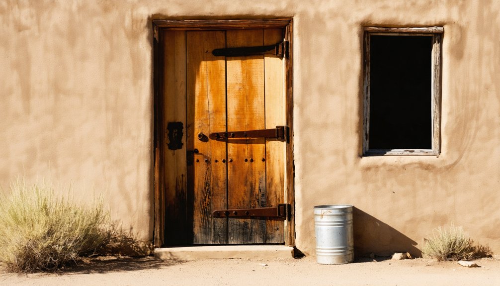
Exploring the Ghost Town Today
You’ll need to navigate a network of dirt roads from Tubac to reach Alto’s remote ruins in the Santa Rita Mountains, though private property restrictions limit some access points.
Once there, you can view scattered mine remnants and foundations from public vantage points along established hiking trails, including the Alto Ruins trail.
The elevated position offers sweeping mountain vistas, but you’ll want to carefully respect posted boundaries and stick to permitted areas while exploring the historic site.
Accessing the Ruins Today
Today, reaching the ghostly remnants of Alto requires careful planning and the right vehicle. Your primary access route runs via Salero Road off Arizona State Route 82, southwest of Patagonia.
Most explorers approach from Patagonia along Blue Haven Road, passing the Paton Center for Hummingbirds and Patagonia-Sonoita Creek Preserve.
You’ll need to prepare for:
- Hard-packed gravel roads that shift into rugged, rocky terrain
- A final 1.5-mile stretch that demands high-clearance vehicles or mountain bikes
- Navigation without formal trails or markers to guide you
- No designated parking areas or facilities at the site
Don’t attempt the journey in a standard passenger car – you’ll risk getting stuck or damaging your vehicle.
Stick to marked roads and respect private property boundaries, particularly around Salero Ranch.
Remote Mountain Trail Views
While climbing through the remote Santa Rita Mountains toward Alto’s ruins, visitors encounter breathtaking vistas that span from desert scrubland to distant mountain peaks.
The trail weaves through the Patagonia-Sonoita Creek Preserve, where you’ll find dramatic elevation changes revealing scenic vistas of the surrounding wilderness. The rugged terrain offers changing perspectives of native grasslands, desert flora, and riparian zones along the creek.
As you navigate the hard-packed gravel roads that shift into rockier paths, you’ll witness nature’s full display – from soaring birds at the nearby Hummingbird Sanctuary to seasonal wildflowers dotting the landscape.
The route’s high points provide sweeping panoramas that are particularly stunning during sunrise and sunset, when the mountain silhouettes stand in sharp relief against the changing sky.
Natural Surroundings and Geography

Nestled deep within the Santa Rita Mountains of Southern Arizona, Alto ghost town occupies an elevated position that perfectly matches its Spanish name meaning “high.”
The remnants of ghost towns in Arizona’s history serve as a testament to the vibrant mining communities that thrived in the late 19th and early 20th centuries. Visitors can explore the dilapidated buildings and artifacts that tell the stories of those who once called these places home. Each ghost town offers a unique glimpse into the harsh realities and fleeting prosperity of the region’s past.
High above the Sonoran Desert floor, Alto ghost town rests in silent dignity among the peaks of Arizona’s Santa Rita range.
The site’s rugged terrain features steep hills and mountainous roads that shift from desert scrub to oak woodland as the elevation rises.
You’ll discover a diverse landscape shaped by elevation changes and surrounding flora:
- Native desert plants like mesquite and ocotillo dominate the lower elevations
- Cottonwood trees line the banks of Harshaw Creek, creating essential riparian zones
- Oak groves emerge as you climb higher into the mountainous terrain
- Seasonal water sources sustain local wildlife, including rare birds and butterflies
The area’s natural character remains preserved through a mix of national forest lands and private ranches, though you’ll need 4WD or hiking boots to explore beyond Salero ghost town.
Legacy of the Santa Rita Mountains
The Santa Rita Mountains harbor a rich mining legacy spanning over three centuries, beginning with Jesuit missionaries from Tumacacori in the 1600s.
Following the Gadsden Purchase of 1853, you’ll find the region transformed as American prospectors, drawn by the promise of mineral wealth, established significant operations like the Mowry Mine.
The Alto Mine near Salero Ranch demonstrated the area’s historical significance, producing over 3,500 tons of lead and silver ore while employing local miners in the early 1900s.
Today, these mountains stand as evidence to the region’s cultural heritage, with remnants of adobe structures and mine shafts dotting the landscape.
While modern copper mining projects like Rosemont and Copper World continue this legacy, they’ve sparked intense debates about preserving the area’s natural and cultural treasures.
Frequently Asked Questions
What Happened to Alto’s Original Inhabitants After the Town Was Abandoned?
You’ll find Alto’s descendants scattered across Arizona and nearby states, as families gradually left the failing silver mines for new opportunities, leaving behind their ghost town history.
Are There Any Documented Paranormal Activities or Ghost Stories From Alto?
You won’t find documented ghost sightings or haunted locations in Alto’s records. Unlike other Arizona ghost towns, there aren’t any verified paranormal encounters – just the natural eeriness of abandoned ruins.
What Tools and Mining Techniques Were Commonly Used in Alto’s Mines?
Before electric lights, you’d find miners using dangerous “widow-maker” pneumatic drills and candles for light. They’d rely on dynamite, sluices, and core drilling equipment for mineral extraction processes.
Did Any Notable Historical Figures or Personalities Ever Visit Alto?
You won’t find records of any notable visitors or historical figures in Alto’s past. Its historical significance stems purely from mining activities, without the celebrity connections that characterized other Arizona ghost towns.
What Native American Tribes Originally Inhabited the Area Before Alto’s Establishment?
You’ll find the Apache and Yavapai peoples were the primary tribes in this region, with deep cultural significance dating back generations before Alto’s establishment. Their tribal history shaped the area’s early character.
References
- https://www.destination4x4.com/alto-arizona-santa-cruz-county-arizona/
- https://www.youtube.com/watch?v=nTdyOGjxGjY
- https://ridewithgps.com/routes/37633972
- https://www.thedieselapartment.com/southern-arizona-ghost-town-alto-camp/
- https://www.ghosttowns.com/states/az/alto.html
- https://kids.kiddle.co/Alto
- https://dirtyfreehub.org/routes/arizona/alto-ruins/
- https://www.youtube.com/shorts/Lim9xbgYKGo
- https://winfirst.wixsite.com/arizonamininghistory/history
- https://santacruzheritage.org/wp-content/uploads/2021/12/Mining-Booms-1.pdf


