You’ll discover America’s forgotten riverside settlements by visiting St. Thomas, Nevada, where drought reveals buildings once submerged by Lake Mead, or Robinette, Oregon, hidden beneath Brownlee Reservoir. Don’t miss Rhyolite’s gold rush remnants, Vanport’s flood legacy, St. Elmo’s well-preserved mining structures, Picher’s toxic waterways, or Harrisburg’s desert ruins. Each abandoned town tells a unique story of America’s complex relationship with water, waiting for your exploration beneath the surface.
Key Takeaways
- St. Thomas, Nevada re-emerges periodically from Lake Mead due to drought, revealing foundations and a two-story schoolhouse.
- Robinette, Oregon lies beneath Brownlee Reservoir since 1958, once a thriving hub for agriculture and rail transport.
- Vanport, Oregon vanished in the 1948 Columbia River flood, displacing 18,500 residents with no memorial marking its existence.
- St. Elmo, Colorado preserves its silver mining legacy with intact buildings in Chalk Creek Canyon.
- Rhyolite, Nevada boomed during the gold rush with opulent mansions before being abandoned by 1916.
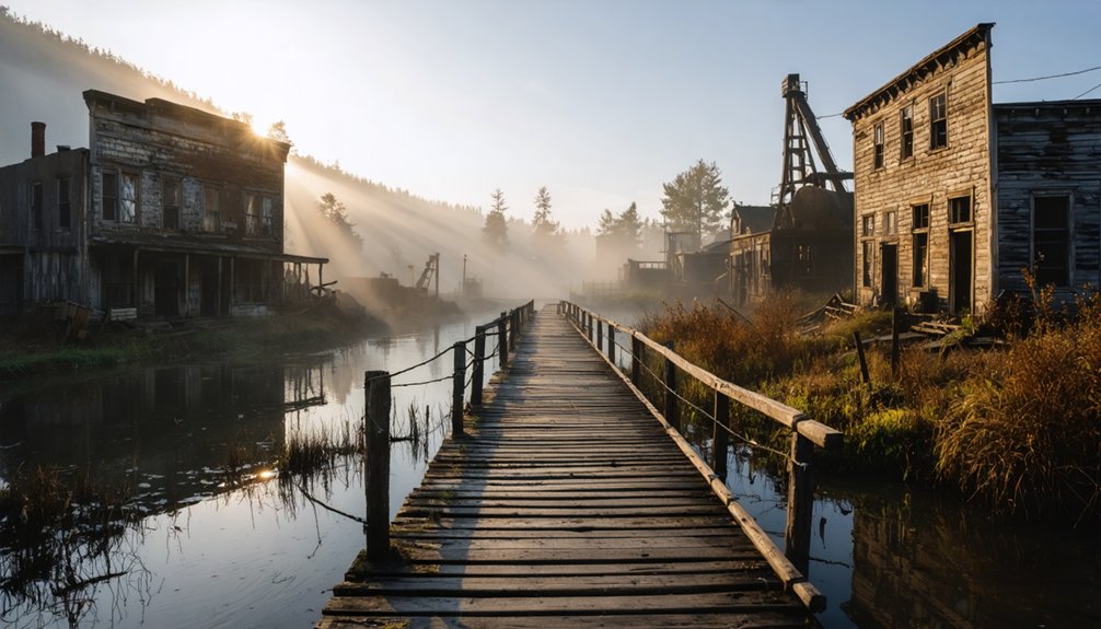
St. Thomas, Nevada: The Town That Rises From Lake Mead
While many abandoned towns slowly crumble under the weight of time and weather, St. Thomas offers a uniquely cyclical fate. Founded in 1865 by Mormon pioneers, this representation of pioneer resilience thrived as an agricultural community until Hoover Dam’s construction sealed its destiny.
By 1938, Lake Mead’s rising waters had claimed the settlement, submerging history beneath 60 feet of water.
Today, ongoing drought has revealed this ghost town’s skeleton, allowing you to walk streets once navigated by boat. Building foundations, cottonwood-lined paths, and remnants of pioneer life emerge from the receding lake. The settlers initially struggled but established impressive irrigation systems from the Muddy River to support their farms. The town featured a prominent two-story schoolhouse with intact steps still visible to visitors today.
The rise and retreat of Lake Mead breathes life into St. Thomas, transforming submerged history into an explorer’s time capsule.
As you explore these ruins within Lake Mead National Recreation Area, you’ll witness a rare convergence of human ambition and natural forces—a town that alternately drowns and resurfaces, marking time through its periods of visibility and concealment.
Robinette, Oregon: Schoolhouse Beneath Brownlee Reservoir
Unlike St. Thomas, you’ll never have the opportunity to walk among Robinette’s remains. This once-thriving Oregon town now slumbers beneath Brownlee Reservoir, submerged since 1958 when Idaho Power completed the 420-foot dam.
Robinette’s rich history began with James Robinette’s settlement in 1887, flourishing into a regional hub for agriculture and rail transport. It served as the northern terminus of the Union Pacific Railroad, connecting the remote region to the broader transportation network. Before its decline, Robinette boasted timber-industry facilities that supported the local economy.
- The one-room schoolhouse, once central to community life, rests 100 feet underwater
- Pete Basche’s photographs preserve Robinette’s final days in haunting detail
- Most buildings, including the distinctive Quonset hut tavern, were abandoned to the rising waters
- The submerged infrastructure includes a train depot, general store, and hotel
- Robinette’s post office operated for nearly 50 years (1909-1958) before inundation
Rhyolite, Nevada: Gold Rush Ghost Town Along the Amargosa
When you wander through Rhyolite’s crumbling ruins, you’re walking the same streets where gold barons once built opulent mansions along “Millionaire’s Row” during the town’s 1907 apex.
The collapsed walls of the Cook Bank Building, once a three-story monument to the town’s prosperity with marble floors and stained glass windows, now stand as Death Valley’s most photographed gilded relic.
Your footsteps echo through this silent sentinel of boom-and-bust economics, where concrete and stone structures have outlasted their wooden counterparts in other mining towns, preserving a rare glimpse into Nevada’s ambitious gold rush architecture. The town’s rapid transformation from a collection of tents to a modern city with electricity and telephones showcases how quickly fortunes were made and lost in the American West. The discovery of gold in 1904 sparked Rhyolite’s meteoric rise before its equally swift decline as mines failed by 1910.
Millionaire’s Row Mansions
Among the remarkable remnants of Rhyolite’s brief prosperity stand the ornate mansions of Millionaire’s Row, proof of the extraordinary wealth extracted from the Bullfrog Mining District between 1905-1908.
These millionaire mansions, constructed with stone and concrete rather than wood, showcased opulent architecture that defied their harsh desert surroundings. As you wander through these skeletal structures today, you’re witnessing the ambitious dreams of those who struck it rich in Nevada’s gold rush.
- Residences featured modern amenities like electricity, running water, and telephones when many American homes lacked such luxuries.
- Local banking magnates and mine owners competed to build increasingly lavish homes.
- Imported materials and furnishings arrived via the town’s state-of-the-art railroad.
- Architectural styles blended Eastern influences with Western frontier practicality.
- Formal gardens once surrounded these homes, creating verdant oases in the desert landscape.
The town’s California-Mission style depot represented the height of architectural elegance before the mining economy collapsed. The abandoned structures now stand as silent witnesses to Nevada’s economic booms and busts, telling the story of fortunes gained and lost in the unpredictable mining industry.
Death Valley’s Gilded Relic
Just four miles west of the Death Valley National Park boundary, Rhyolite stands as the Mojave Desert’s most impressive ghost town, a gilded relic of America’s final gold rush.
After Harris and Cross discovered gold in 1904, this two-tent camp exploded into a thriving metropolis of 5,000 residents with banks, churches, and a state-of-the-art railroad depot.
Unlike typical wooden mining settlements, Rhyolite’s builders used stone and concrete, leaving behind substantial ruins for you to explore.
The town’s dramatic collapse came as swiftly as its rise. By 1916, just a decade after its founding, the gold mining operations had failed, electricity was cut, and Rhyolite stood abandoned.
The surrounding landscape features distinctive light-colored volcanic rock that gave the town its geological namesake, known for its high silica content and formation from explosive eruptions.
Today, you can wander among the Cook Bank Building, the unique Bottle House, and other crumbling structures maintained by the Bureau of Land Management. The area has also served as a backdrop for various Hollywood productions, including Alanis Morissette’s iconic music video “You Oughta Know”.
Collapsed Bank Ruins
The three-story John Cook Bank Building stands as Rhyolite’s most imposing architectural remnant, its collapsed façade a symbol of both ambitious financial aspirations and ultimate economic failure.
As you wander through these ruins along the Amargosa River, you’re witnessing the skeletal remains of a financial institution that once served 8,000 residents during Rhyolite’s brief golden era from 1905 to 1910.
- Concrete walls endure while other structures have completely vanished, showcasing early 20th-century construction techniques
- Historical significance preserved by Bureau of Land Management protection status
- Collapsed architecture tells the story of rapid boom-and-bust economics
- Once housed financial transactions for one of Nevada’s most promising mining settlements
- Standing amid these ruins offers a tangible connection to America’s last great gold rushes
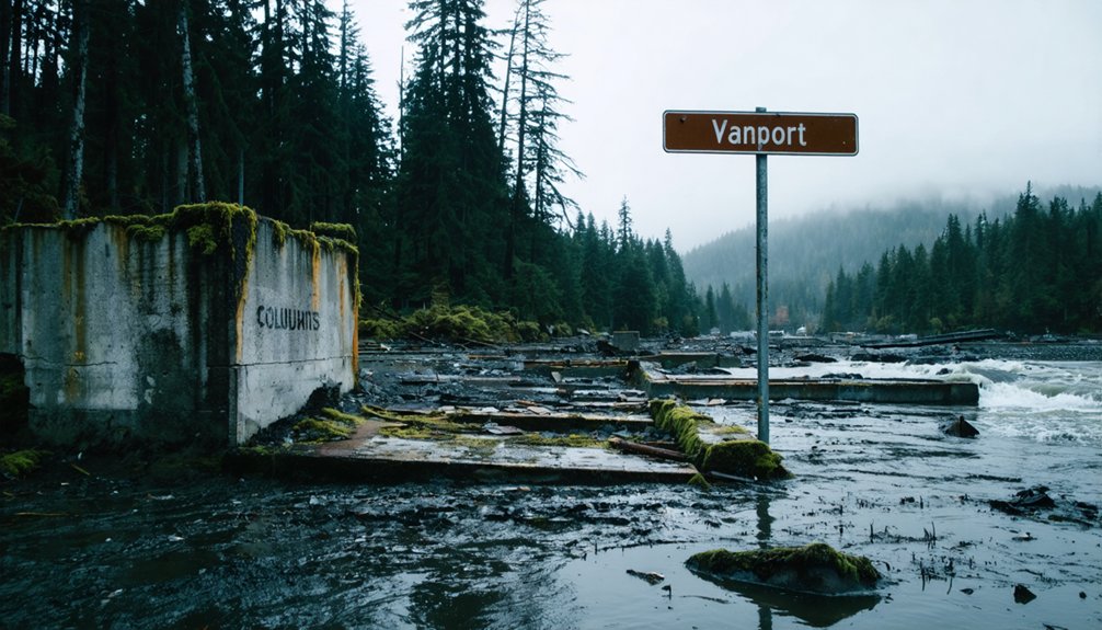
Vanport, Oregon: Columbia River’s Lost City
If you’re searching for phantom cities that once thrived alongside America’s waterways, you’ll find few stories as haunting as Vanport, Oregon—nicknamed “The Second Detroit” for its rapid industrial growth and diverse workforce.
As you explore these historical remnants, California also offers its share of abandoned ghost towns in California that tell tales of fortune and despair. Towns like Bodie and Calico, once bustling with activity during the Gold Rush, now stand as haunting snapshots of the past. Each dilapidated building and weary street echoes stories of the hopes and dreams that once filled them.
Built with unprecedented speed during World War II, this boomtown housed 40,000 residents until May 30, 1948, when the Columbia River breached its barriers and erased the entire city in less than an hour.
Today, as you walk through Delta Park or drive past Portland International Raceway, you’re treading on the ghosts of a community that vanished beneath the floodwaters, leaving thousands displaced and a chapter of Oregon history permanently altered.
The Second Detroit
Built in a remarkable 110 days during 1942, Vanport emerged as a hastily constructed solution to Portland’s critical wartime housing shortage. As America’s largest federal housing project, this temporary community became Oregon’s second-largest city, with 40,000 residents at its peak.
The urban displacement that followed the 1948 flood fundamentally altered Portland’s demographics as thousands of survivors, many African-American, settled in the Albina district.
- Nicknamed “Miracle City” before racial tensions transformed its reputation
- Featured unprecedented racial integration with integrated schools in segregated Oregon
- Constructed on vulnerable floodplain with wooden foundations and fiberboard walls
- Surrounded entirely by water, with dikes that ultimately failed to protect residents
- Represented a brief experiment in desegregation where Black residents comprised 40% of the population
Flood of ’48
While most Americans were enjoying Memorial Day festivities on May 30, 1948, residents of Vanport faced an unimaginable catastrophe as a six-foot breach in the railroad embankment rapidly expanded to a 500-foot gap, releasing the swollen Columbia River.
Within an hour, Oregon’s second-largest city vanished. You can still sense the tragedy’s scale as you explore this history—over 18,500 residents displaced, entire buildings swept from foundations.
The flood impact was particularly severe for African American residents, who comprised nearly a third of Vanport’s population and subsequently resettled in Portland’s Albina neighborhood.
Today, where this wartime housing project once stood, you’ll find only a raceway, golf course, and businesses—no memorial to the lost city that remained underwater for weeks after that fateful day.
St. Elmo, Colorado: Preserved Mining Legacy on Chalk Creek
Nestled within the rugged folds of Chalk Creek Canyon, St. Elmo stands as one of Colorado’s best-preserved ghost towns, offering you a glimpse into America’s mining past.
Originally called Forest City, this once-thriving community boomed after Abner Wright and John Royal’s 1875 silver discovery led to the Mary Murphy Mine—a powerhouse that produced $60 million in ore through innovative mining technology including aerial tramways and mercury separation techniques.
- Walk among wooden structures that housed nearly 2,000 residents during the 1880s peak
- Marvel at the engineering of mine tunnels that penetrated veins exceeding 25 feet wide
- Explore a town once bustling with banks, sawmills, and smelters
- Trace the path of the Denver, South Park and Pacific Railroad that transformed local commerce
- Witness preservation efforts that keep St. Elmo’s mining legacy alive for future generations
Picher, Oklahoma: Toxic Waters and Mining Remnants
Picher, Oklahoma stands as a stark monument to the devastating aftermath of industrial prosperity turned toxic nightmare.
Once a thriving boomtown that supplied over half the lead and zinc for both World Wars, you’ll now find only ghost-like remnants of its mining history.
As you explore, you’ll encounter massive chat piles—mountains of contaminated gravel waste that dominate the landscape.
The town’s toxic legacy includes creeks running red with heavy metals and buildings slowly sinking into abandoned mine shafts below.
By 2009, the federal government completed a buyout, officially closing this chapter of American industry.
Walking these grounds offers a sobering reminder of freedom’s price when environmental stewardship is sacrificed for economic gain—a cautionary tale written in abandoned mills and poisoned waters.
Harrisburg, Utah: Desert River Settlement Claimed by Nature
Standing silent beneath the desert sun, Harrisburg represents one of Utah’s most poignant tales of pioneer ambition thwarted by nature’s unforgiving hand. Founded in 1859 near the Virgin River, this Mormon settlement’s history reveals the fragility of human endeavors against environmental forces.
You’ll find pioneer architecture in the remaining stone structures, particularly the restored Adams House, built between 1862-1865.
- Stone dwellings stand as evidence to early settlers’ determination
- Virgin River flooding in 1862 forced relocation to higher ground
- Grasshopper plagues of 1869 triggered the settlement’s ultimate decline
- Access requires traversing under Interstate 15 via a single-lane road
- By 1895, the last residents departed, surrendering their dreams to the desert
Frequently Asked Questions
Is It Legal to Collect Artifacts From Abandoned River Towns?
While history beckons, legal implications restrict you. Artifact preservation laws prohibit collection without proper permission—you’ll need landowner consent on private property and can’t collect from federal/state lands whatsoever.
How Can I Safely Explore Submerged Towns During Low Water Periods?
You’ll need to monitor water levels closely, wear appropriate protective gear, and bring communication devices. Always respect environmental considerations by avoiding disturbance of aquatic ecosystems while honoring these nostalgic, submerged memories beneath your feet.
Are There Guided Tours Available to These Abandoned Sites?
Yes, you’ll find guided exploration options at most abandoned river towns. Local historical societies frequently lead tours highlighting the historical significance of these forgotten places, especially during spring and summer months.
What Photography Equipment Works Best for Underwater Town Documentation?
Like the team documenting St. Thomas in Lake Mead, you’ll need a DSLR with waterproof housing, wide-angle lenses, and external strobes for effective underwater photography of these submerged historical sites.
Do Any Former Residents Still Hold Reunions at These Locations?
Yes, you’ll find vibrant reunion events where descendants gather at submerged towns like Elbowoods when water levels permit, and regular celebrations at preserved sites like Garnet, where resident memories endure through storytelling.
References
- https://www.neh.gov/article/atlas-drowned-towns
- https://dot.ca.gov/-/media/dot-media/programs/environmental-analysis/documents/ser/townsites-a11y.pdf
- https://www.geotab.com/ghost-towns/
- https://en.wikipedia.org/wiki/Wikipedia:WikiProject_Ghost_towns
- https://www.youtube.com/watch?v=YT8a1HbiyNI
- https://handbill.hk/editor_upload/file/1f47de58-e829-419c-ab5d-deae4a07d2ca.pdf
- https://www.mentalfloss.com/article/65859/10-american-ghost-towns-you-can-visit
- https://backroadplanet.com/10-river-towns-with-rich-histories/
- https://en.wikipedia.org/wiki/Ghost_town
- https://en.wikipedia.org/wiki/List_of_flooded_towns_in_the_United_States