Yes, you’ll find several fascinating ghost towns across Massachusetts, including the mysterious Dogtown near Gloucester, the submerged villages of Quabbin Reservoir, and the floating settlement of Long Point in Provincetown. These abandoned communities reveal stories of colonial life, industrial decline, and forced displacement from the 1800s through the early 1900s. Each site’s stone foundations, cellar holes, and preserved structures offer tangible connections to Massachusetts’ complex past.
Key Takeaways
- Massachusetts has several ghost towns including Prescott, Dana, Greenwich, and Monson Center, each with preserved historical remnants.
- Long Point was a thriving fishing settlement that declined when residents floated their homes to mainland Provincetown in the 1850s.
- Dogtown, near Gloucester, became abandoned after transforming from a farming community to a refuge for social outcasts.
- The creation of Quabbin Reservoir in 1927 submerged four historic towns, displacing over 2,500 residents.
- Norton Furnace operated as an industrial village from 1825 until the early 20th century, now existing as ruins and hiking trails.
The Historical Significance of Massachusetts Ghost Towns
While many of America’s ghost towns emerged from abandoned mining operations out West, Massachusetts’ ghost towns tell a unique story of community displacement and social transformation.
From the lost communities of Prescott, Dana, and Greenwich submerged beneath Quabbin Reservoir to the historic ruins of Monson Center, you’ll discover settlements shaped by colonial survival, social outcasts, and infrastructure demands.
The abandoned architecture of places like Dogtown reveals tales of witchcraft accusations and marginalized residents seeking refuge, while Hawley’s overgrown town common reflects the region’s shifting demographics. Some towns, like the original Grafton, Massachusetts, served as inspiration for naming other settlements across America.
These ghost towns preserve essential evidence of early American life through stone foundations, cellar holes, and wall remnants. The former village of Catamount showcases how many abandoned settlements became part of state forests.
Each site represents different aspects of Massachusetts’ evolution – from colonial defense strategies to Boston’s growing water needs.
Long Point: A Floating Community’s Legacy
You’ll find the remarkable story of Long Point in Massachusetts’ maritime past, where a thriving fishing settlement of over 200 residents once flourished at the tip of Cape Cod between 1818 and the 1850s.
At its peak, the community boasted nearly 40 homes, multiple saltworks, windmills, a schoolhouse, and a lighthouse that served as a beacon for the local fishing fleet. These houses were transported on flat-bottomed scows during high tide. Grace Collinson observed residents continuing their daily routines, even knitting and cooking soup during the unusual journey.
When economic hardship struck in the mid-19th century, residents undertook an extraordinary feat of preservation by floating their homes across Provincetown Harbor to the mainland, where many of these “floater” houses still stand today marked by distinctive blue-and-white plaques.
Life on the Peninsula
On the windswept edge of Provincetown Harbor, Long Point emerged as a thriving maritime community in 1818 when John Atwood built the peninsula’s first house.
Within three decades, you’d have found a bustling settlement of 260 residents practicing traditional fishing practices and operating six windmills for the local salt works.
The community’s resilience was evident in their resourceful development of essential structures.
You would’ve seen 38 homes, a post office, a schoolhouse built in 1846, and a wharf serving the fishing fleet.
Daily life centered around the general store, bakery, and the Long Point Lighthouse, erected in 1827.
Children attended classes initially held in the lighthouse before moving to their dedicated schoolhouse, while fishermen worked the rich offshore waters that had drawn them to this remote stretch of sand.
During the Civil War, the area became home to Fort Useless and Ridiculous, two military installations that never saw combat.
When the village declined, residents transported their houses to Provincetown’s mainland, floating them across the harbor to establish new homes.
Thriving Fishing Settlement
Long Point’s emergence as an essential fishing settlement transformed the remote peninsula into an economic powerhouse during the mid-1800s.
You’ll find that by the 1840s, this thriving community supported about 200 residents who mastered profitable fishing techniques using hand-knit sweep seines. Their impressive hauls could yield up to seventy-five 200-pound barrels of white shad in a single catch.
The settlement’s success wasn’t limited to fishing alone. You would’ve seen nine windmills pumping seawater into vast evaporation pans for salt production, while a bustling village infrastructure included a post office, bakery, general store, and schoolhouse. The community produced an astounding 280,000 to 336,000 pounds of salt annually for both domestic use and fish preservation. Local fishermen caught abundant lobsters that were shipped to New York markets for just two cents each.
However, by the 1850s, economic decline set in as overfishing depleted local stocks and new refrigeration technology reduced demand for salt-cured fish, ultimately leading to the community’s gradual departure.
Floating Homes Journey
Nearly thirty homes set out on a remarkable journey across Provincetown Harbor when Long Point’s residents decided to relocate their community in the 1850s.
You’ll find it fascinating how these floating homes made their changeover: they were carefully placed on scows or rafts at high tide, then skillfully skidded across the harbor at low water to Provincetown’s West End. Similar to these relocations, many houses were moved from Billingsgate and Bound Brook to adapt to changing environmental conditions.
The process was so gentle that, according to Mary Heaton Vorse, cooking wasn’t even disrupted during transport. A local Deacon specialized in these building moves, while women packed their belongings in dories. The community’s decline was largely due to the lack of fresh water, forcing residents to rely on rainwater collection.
Today, you can spot these historic homes in Provincetown’s West End, marked by distinctive blue-and-white plaques designed by Claude Jensen in the 1970s, each depicting a houseboat against the Long Point Light backdrop.
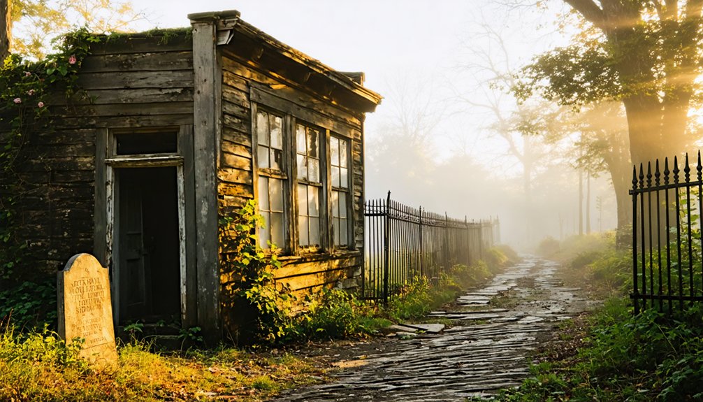
Dogtown’s Dark Past and Mysterious Tales
As you explore Dogtown’s haunting past, you’ll find a community that became increasingly isolated in the early 1800s, earning a reputation for housing social outcasts and alleged practitioners of witchcraft.
The settlement’s mystique deepened through tales of Thomazine “Tammy” Younger, known locally as the “Queen of the Witches,” who supposedly demanded offerings from travelers passing through the area.
The last known inhabitant, Cornelius “Black Neil” Finson, embodied the settlement’s tragic decline when authorities removed him to a Gloucester poorhouse around 1830, marking the final chapter of permanent human residence in Dogtown.
Outcasts and Social Isolation
During the early nineteenth century, Dogtown’s population transformed from a thriving farming community into a refuge for society’s outcasts. You’ll find that after the Revolutionary War and War of 1812, the settlement became home to widows, single women, freed Black people, and other marginalized individuals living on society’s edge.
Economic vulnerability plagued these residents, who relied on gifts from passersby and struggled with the area’s poor farming conditions. The isolation of Dogtown’s rocky highlands, combined with growing social stigma, created a cycle of abandonment.
Local rumors of witchcraft and eccentric behavior, particularly targeting solitary women, further ostracized the remaining inhabitants. One notable resident, “Black Neil” Finson, exemplified this struggle – forced to leave his home for a poorhouse in 1830, marking the settlement’s final decline.
Tales of Witchcraft Activities
The dark reputation of Dogtown’s witchcraft activities centered around Thomazine “Tammy” Younger, a formidable woman known in local folklore as the “Queen of the Witches.”
From her home on Fox Hill near Alewife Brook, she’d demand tolls from travelers through alleged supernatural coercion, using threats of bewitched oxen and cursed cattle to extract offerings of food, fish, and corn.
You’ll find other names woven into Dogtown’s witch folklore, including Luce George, Molly Stevens, and Judy Rhines.
These women, often widowed or single, made their living through fortune-telling and shrewd business practices.
While supernatural tales of werewolves, woodland cackles, and creepy dolls persist, no witch trials or executions occurred here.
Instead, these independent women’s reputations grew from post-Revolutionary War poverty and social isolation rather than actual wrongdoing.
Final Resident’s Tragic End
In one of history’s bleakest chapters, Cornelius “Black Neil” Finson became Dogtown’s final resident – a freed slave who stubbornly remained after all others departed by 1828.
Living in an abandoned cellar-hole, Finson’s survival tested the limits of human endurance as he battled harsh winters and complete isolation.
You’ll find his story marks a tragic end to Dogtown’s legacy. In 1830, townspeople discovered him near death, his feet frozen in his makeshift shelter.
They rushed him to Gloucester’s poor house, but he died shortly after arrival. With Finson’s passing, Dogtown’s last human presence vanished forever.
The village that once thrived became a true ghost town, its structures razed by 1845, leaving only cellar holes and memories of its final inhabitant’s desperate struggle.
The Lost Villages of Quabbin Reservoir
Created by one of America’s most ambitious water projects, Quabbin Reservoir forever transformed Massachusetts’ Swift River Valley when construction began in 1927.
The project claimed four historic towns – Dana, Enfield, Prescott, and Greenwich – displacing over 2,500 residents from their ancestral lands.
These lost communities once thrived with Victorian homes, bustling mills, and a vibrant railway system.
You’d have found six churches, 13 schools, and 60 summer camps before engineers systematically dismantled every structure.
Even the dead weren’t left to rest – workers exhumed and relocated over 7,000 bodies to Quabbin Memorial Park.
Catamount: From Patriotic Symbol to Abandoned Settlement

While Quabbin’s lost towns represent Massachusetts’ most famous ghost settlements, another fascinating abandoned community sits quietly in Franklin County’s hills.
Catamount history began in the mid-1700s as a small farming village, gaining national recognition in 1812 when its schoolhouse became the first in America to fly the U.S. flag.
From humble farming roots to American history, Catamount’s pioneering spirit soared as its schoolhouse first raised the Stars and Stripes.
You’ll find this ghost town‘s remains within today’s Catamount State Forest, where stone walls and cellar holes tell stories of a once-thriving hilltown community.
- The village’s decline mirrors many New England hilltowns that couldn’t sustain themselves through subsistence farming alone.
- Catamount preservation efforts now focus on protecting archaeological features within state forest boundaries.
- You can still explore old roadbeds and foundation stones on foot, though most original structures have vanished.
Whitewash Village: Hidden Remnants of Provincetown
Monomoy Island’s elusive Whitewash Village stands as one of Massachusetts’ most intriguing lost settlements. Founded around 1710, this maritime community thrived off Cape Cod’s rich fishing grounds, with Stewart’s Tavern serving as a haven for shipwrecked sailors and seafarers.
The village drew its name from either whitewashed rocks or buildings that dotted the landscape.
You’ll find no trace of the original structures today – they’ve surrendered to time and tide. By the 1860s, a perfect storm of challenges sealed the village’s fate: depleted fish stocks, cheaper salt production elsewhere, and a devastating winter storm that filled their essential harbor with sand.
Residents relocated to mainland towns, some even floating their dismantled homes across the water. This vanished piece of maritime heritage now lies beneath Monomoy’s shifting sands, revealed only occasionally by fierce storms.
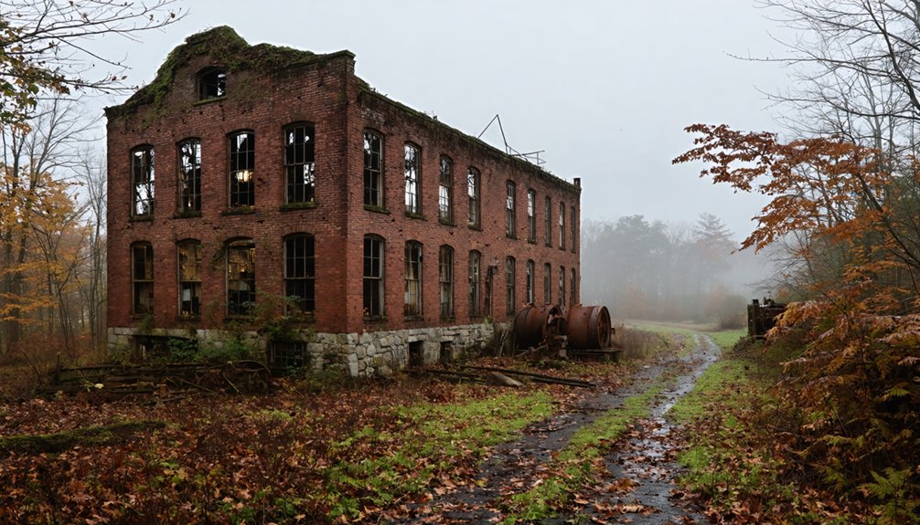
Norton Furnace: Industrial Revolution Ruins

You’ll find the ruins of Norton Furnace among the most compelling remnants of Massachusetts’ Industrial Revolution, where iron manufacturing once flourished from 1825 through the early 20th century.
At its peak in 1865, the furnace employed 65 workers and produced $90,000 worth of hollowware and castings, exploiting the area’s rich bog iron resources.
Today, you can explore this quiet residential area’s industrial heritage along hiking trails that trace the former factory grounds, where ruins stand as silent witnesses to Norton’s once-bustling iron industry.
Iron Production History
In southeastern Massachusetts, where colonial iron production once thrived, the Norton Furnace stands as a symbol to the region’s industrial heritage. Established in 1825 by Annes A. Lincoln, this historical landmark operated along a tributary of the Three Mile River, marking the beginning of specialized ironmaking in the area.
You’ll find that by 1900, the site had evolved into a bustling industrial center with its own post office and railway station.
- The furnace’s strategic location near water sources enabled the shift from iron to copper production, showcasing early American industrial adaptability.
- Immigrant communities shaped the village’s growth, creating a unique cultural legacy tied to manufacturing.
- The site’s transformation from iron works to copper mill to ice harvesting facility demonstrates the dynamic nature of industrial evolution.
Abandoned Site Features
Today’s visitors to Norton Furnace encounter a landscape of industrial ruins that tells the story of Massachusetts’ manufacturing heritage.
You’ll find stone foundations marking former furnace buildings along Meadow Brook’s trails, while scattered walls reveal where worker housing once stood. The site’s industrial archaeology includes remnants of millraces, railroad embankments, and water-management features from the 1860s Old Colony branch line.
These historical remnants paint a picture of a compact village with its industrial core surrounded by about 25 worker houses.
While modern development and natural processes have altered some features, you can still explore the site’s public portions via hiking trails.
Look for slag deposits, metalworking waste, and domestic artifacts that hint at daily life in this once-bustling industrial community.
Geographic Challenges Leading to Abandonment
While Massachusetts ghost towns share many common abandonment factors, their geographic challenges proved especially decisive in hastening their demise.
exploring ghost towns in Massachusetts reveals not only the stories of their former inhabitants but also the environmental issues that contributed to their decline. Many towns were established in remote locations, making them vulnerable to natural disasters and economic shifts. As a result, these once-thriving communities fell into ruin, leaving behind a haunting but fascinating legacy.
Today, many ghost towns available in Massachusetts can be visited, offering a glimpse into the past and a chance to reflect on the factors that led to their abandonment. Enthusiasts often venture out to explore these forgotten places, uncovering remnants of architecture and stories that echo through time. The juxtaposition of nature reclaiming these towns against their historical significance provides a unique experience for visitors.
Geographic isolation, particularly in wooded areas like Dogtown’s 3,600-acre terrain, created natural barriers that limited accessibility and development. Rural depopulation accelerated as communities struggled against challenging landscapes and competition from better-situated suburbs.
You’ll find these abandoned settlements were often victims of their remote locations, cut off from economic opportunities and essential services.
- Natural barriers like thick forests and boulder formations made transportation and expansion nearly impossible
- Flood risks and water-related challenges forced relocation from vulnerable areas
- Competition from accessible suburban areas drew residents away from isolated communities, especially during the 1950s
Preserving Massachusetts’ Ghost Town History
Dedicated preservation organizations have worked tirelessly to protect Massachusetts’ ghost towns from development and decay since the 1930s.
You’ll find the Trustees of Reservations managing the 438-acre Questing Reservation, while also overseeing Dogtown‘s 1,150 acres, which Roger Babson donated in 1935. The Massachusetts Historical Commission maintains detailed documentation of these historic sites.
You can explore remarkably preserved locations like Monson Center, with its centuries-old stone foundations spanning 17,000 acres – saved from subdivision by a grassroots campaign in 1998.
At Dogtown, you’ll discover numbered cellar holes and inscribed boulders that Babson marked in 1927 for historical documentation.
These ghost town preservation efforts guarantee you’ll have access to these fascinating remnants of Massachusetts’ past for generations to come.
Exploring these haunted destinations in Massachusetts allows visitors to engage with the rich history and eerie tales that linger in the air. Each location tells its own story, drawing in those intrigued by the supernatural and the mysteries of the past. As you wander through these sites, you’ll not only witness the remnants of history but also feel the unique atmosphere that characterizes this state.
Many of these ghost towns located in Massachusetts are shrouded in legends that captivate the imagination. Visitors often report strange occurrences and unexplained phenomena, adding an element of excitement to their explorations. Each site serves as a time capsule, preserving not only structures but also the stories and spirits of those who once called these places home.
The Impact of Water Projects on Displaced Communities
In one of Massachusetts’ most controversial water projects, the creation of Quabbin Reservoir displaced over 2,500 residents from four historic towns – Dana, Enfield, Greenwich, and Prescott.
You’ll find that the displacement challenges faced by these communities began in 1928 when the Metropolitan District Water Supply Commission started the massive project to provide water for Boston’s growing population.
- The towns’ residents were forced to abandon their farms, mills, and factories, leaving behind generations of history and community ties.
- Greenwich’s hills now form islands within the reservoir, serving as silent reminders of what lies beneath.
- Despite promises of relocation support in 1922, the flooding of these western Massachusetts towns represents one of the state’s most significant forced community dispersals.
The reservoir impacts continue to shape the region’s identity, while providing water to millions.
Frequently Asked Questions
Are Any Massachusetts Ghost Towns Legally Accessible for Public Exploration Today?
Like portals to the past, you’ll find Dogtown and Catamount State Forest welcome your footsteps today, though safety regulations and historical preservation guidelines shape how you’ll explore these accessible ghost towns.
What Valuable Artifacts Have Been Recovered From Massachusetts Ghost Town Sites?
You’ll find archaeological findings at these sites include preserved stone foundations, readable burial markers, submerged town structures, cast iron lighthouse remnants, and whitewashed stone traces – all with significant historical artifact value.
Do Any Original Residents’ Descendants Still Visit These Ghost Towns?
You’ll find descendants regularly visiting former town sites through organized family reunions, memorial services, and research trips. They honor their ancestral connections at places like Quabbin Valley and Dogtown’s historic markers.
Which Massachusetts Ghost Towns Have Reported Paranormal Activity or Haunting Claims?
Like whispers echoing through time, you’ll find the most documented ghost sightings at Dogtown in Gloucester and near the Hoosac Tunnel, with haunted locations throughout the Bridgewater Triangle’s abandoned settlements.
How Many Undiscovered Ghost Towns Might Still Exist in Massachusetts?
You’ll likely find dozens of undiscovered locations across Massachusetts, as historical records suggest many early settlements vanished without documentation. Colonial-era foundations and cellar holes remain hidden beneath centuries of forest growth.
References
- https://en.wikipedia.org/wiki/List_of_ghost_towns_in_Massachusetts
- https://bostonuncovered.com/ghost-towns-massachusetts/
- https://historyofmassachusetts.org/ghost-towns-massachusetts/
- https://www.geotab.com/ghost-towns/
- https://www.atlasobscura.com/things-to-do/massachusetts/ghost-towns
- https://wnaw.com/ma-ghost-towns-hiking/
- https://senatorjocomerford.org/11-ghost-town-busters/
- https://www.tripadvisor.com/Attractions-g28942-Activities-c47-t14-Massachusetts.html
- https://zionriversedgeadventures.com/article/the-history-behind-graftons-ghost-town
- https://travelnoire.com/abandoned-town-in-northern-massachusetts


