You’ll find Attalia, Washington submerged 16 feet beneath Lake Wallula’s waters, a tribute to the region’s hydroelectric progress. This former railway hub, established in 1906, served as an essential junction for the Northern Pacific Railway and Oregon Railroad until 1953. The McNary Dam project and devastating 1948 flood sealed the town’s fate, forcing its abandonment. Beneath the surface, Attalia’s remnants tell a compelling story of the Pacific Northwest’s changing landscape.
Key Takeaways
- Attalia was a railway junction town in Washington state that operated from 1906 until its submersion beneath Lake Wallula in 1953.
- The town served as a vital transportation hub where the Northern Pacific Railway and Oregon Railroad met along the Columbia River.
- The construction of McNary Dam in 1947 and subsequent formation of Lake Wallula led to Attalia’s complete submergence.
- Remnants of the ghost town, including railroad infrastructure and early 1900s artifacts, now lie 16 feet underwater.
- The town’s Italian heritage and role in Pacific Northwest transportation made it historically significant before becoming a submerged ghost town.
Early Settlement and Town Origins
While its name drew inspiration from Italy, Attalia emerged as a small riverside community along the Columbia River‘s eastern shore in Washington state, roughly 8 miles downstream from Burbank.
You’ll find its roots in early commerce and river transport, as settlers recognized the strategic value of this elevated location along the Columbia’s banks. Much like Wilkerson’s later success with its sandstone quarry, Attalia positioned itself to leverage natural resources.
The town gained official recognition when its post office opened in 1906, marking Attalia as a functioning community in Walla Walla County.
Early residents capitalized on the riverside location for trade and transportation opportunities, establishing themselves as part of the growing network of settlements along the Columbia River corridor. Much like the ancient city of Antalya which thrived through its port trade exports, the town’s location made it ideal for shipping agricultural goods.
The Columbia River’s vital transportation routes fueled growth in riverside settlements, transforming small outposts into bustling trading hubs.
The town’s Italian-influenced name reflects the cultural heritage of some early settlers who helped shape this early 20th-century community.
Railway Junction and Transportation Hub
Building upon its strategic riverside location, Attalia emerged as a significant railway junction by 1909, serving as an essential stop for both the Northern Pacific Railway and Oregon Railroad and Navigation Company.
Located 8 miles downriver from Burbank and roughly 12.5 miles from Pasco, you’ll find this was more than just another stop on the railway expansion through Washington State. The railway system’s standard-gauge tracks enabled efficient freight movement through the region.
Attalia’s transport logistics made it indispensable for regional commerce. The junction’s position allowed seamless transfers between rail lines while offering river access for multi-modal shipping.
You could move agricultural products from Eastern Washington to distant markets through this key hub. This transport nexus operated successfully until 1953, when Lake Wallula’s creation submerged the townsite following McNary Dam’s construction.
Daily Life and Community Development
Despite its relatively brief existence, Attalia’s daily life centered around the rhythms of railway schedules and river commerce from 1906 to 1952.
You’d find families and workers gathering near the railway station, where social interactions revolved around transport schedules and local trade activities. Like its namesake city in Turkey that was founded by King Attalus II, the Washington town carried historical significance in its name. Similar to the Central Washington Railway that established Govan in 1889, the railroad played a vital role in connecting the community to the wider region.
The community’s spirit was shaped by its strategic location and diverse influences:
- Community gatherings likely took place informally among transport workers and farming families
- Italian heritage influenced the town’s identity, reflected in its naming and cultural practices
- Daily routines were guided by the natural cycles of river traffic and agricultural seasons
While formal records of schools and churches remain scarce, you can imagine a close-knit community where neighbors supported each other until McNary Dam’s waters claimed their town in 1953.
McNary Dam Project and Flooding
As the Columbia River basin entered the post-war era, the McNary Dam project emerged as a transformative force that would ultimately claim Attalia and several other riverside communities.
When dam construction began in 1947, you’d find workers battling unprecedented challenges, including the devastating 1948 flood that overwhelmed their newly-built cofferdam with flows three times the average. The flood reached peak flows of 633,000 cubic feet per second through the area.
The project’s impact on Attalia proved permanent and decisive. The Portland District USACE spent two years on initial design work before construction could begin.
As Lake Wallula formed behind the dam in 1953, you’d watch the waters rise to submerge the town completely, along with neighboring communities like New Wallula and Two Rivers.
While the dam brought improved flood management to the Columbia River system, it came at the cost of displacing entire communities and forever altering the river valley’s historic landscape.
Legacy Beneath Lake Wallula
Today beneath Lake Wallula’s tranquil waters, Attalia’s remnants rest at a depth of 16 feet, marking the permanent transformation of this once-bustling railroad town.
While underwater archaeology potential exists, the lake’s conditions make exploring this submerged heritage challenging, leaving most artifacts untouched and preserved in time. The lake formed after the McNary Dam construction in 1947 forever changed the landscape of the region. Regular steamship service once made this location vital for transporting livestock and agricultural goods to coastal markets.
You’ll find evidence of Attalia’s legacy in three distinct ways:
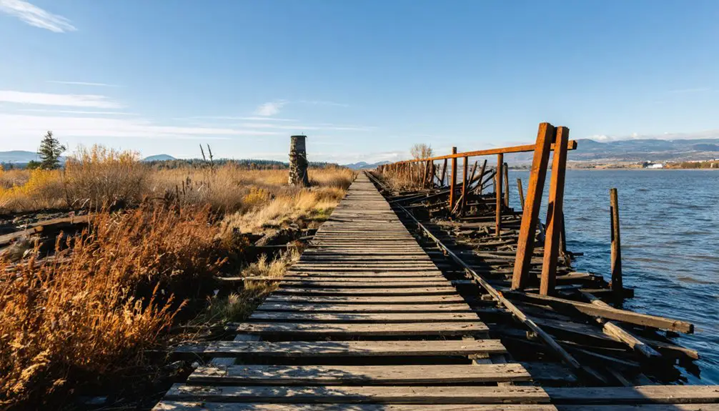
- Railroad infrastructure remains silently beneath the water, including original track beds from the Northern Pacific and Oregon Railroad lines
- Physical structures and early 1900s artifacts create an underwater time capsule
- Environmental changes continue to shape the area as wildlife adapts to the reservoir habitat
The flooding may have erased surface traces, but Attalia’s story lives on through historical records, postcards, and the memories of those who called it home.
Historical Significance and Preservation
While Lake Wallula‘s waters conceal Attalia’s physical remains, the town’s historical importance extends far beyond its submerged foundations.
You’ll find its legacy preserved through railway documents, postcards dating to 1912, and oral histories that showcase strong cultural ties to both Italian heritage and America’s western expansion.
The town’s strategic location as a railway junction for the Northern Pacific and Oregon Railroad made it essential to regional development.
A significant piece of the town’s memory lives on through real photo postcards that capture daily life in the early 1900s.
Though you can’t visit the original site today, Attalia’s story lives on through historical societies and digital archives, representing a significant chapter in Washington’s transformation.
The town’s submersion in 1953 mirrors countless other communities that sacrificed their community identity to hydroelectric progress, making it an important case study in the Pacific Northwest’s evolving landscape.
Frequently Asked Questions
Were There Any Notable Disasters or Accidents in Attalia Before Its Flooding?
You won’t find any documented disaster events or accident reports before Attalia’s flooding in 1953. The town operated normally as a railway stop until Lake Wallula submerged it due to dam construction.
What Happened to the Residents When They Had to Relocate?
You’ll find that residents faced serious relocation challenges, scattering to nearby towns like Burbank. They didn’t receive much government support, and their tight-knit community broke apart during this forced displacement.
Did Any Businesses From Attalia Relocate to Nearby Towns?
You won’t find documented business migration records, but the economic impact likely dispersed operations to Burbank and Pasco. Any changes were probably informal as businesses adapted to McNary Dam’s flooding.
Were There Any Archaeological Findings During the Dam Construction Process?
You won’t find documented archaeological evidence from Attalia during McNary Dam construction. No official records exist of artifact recoveries or excavations before the town was submerged under Lake Wallula.
What Was the Peak Population of Attalia During Its Existence?
Like a fading railway whistle, Attalia’s peak population remains shrouded in mystery. You’d find no official records, though its railroad junction status and post office suggest several hundred residents during its early 1900s heyday.
References
- https://www.wikiwand.com/en/articles/Attalia
- https://en.wikipedia.org/wiki/Attalia
- https://en.wikipedia-on-ipfs.org/wiki/List_of_ghost_towns_in_Washington
- https://en.wikipedia.org/wiki/List_of_ghost_towns_in_Washington
- https://www.wikiwand.com/en/articles/List_of_ghost_towns_in_Washington
- https://www.youtube.com/watch?v=1q77bS12tTo
- https://www.atlasobscura.com/articles/centralia-pennsylvania-2014
- https://www.lewistalk.com/2018/07/15/ghost-town-claquato-washington/
- https://washingtonstate.fandom.com/wiki/Attalia
- https://utahrails.net/pdf/UP_OWRR&N-Corp-History_1916.pdf