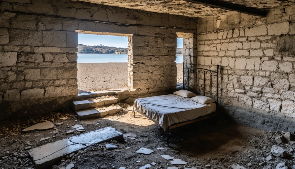
You’ll find the ghost town of Monticello beneath Lake Berryessa’s waters in California, where it was deliberately submerged in 1957 during the Solano Project’s dam construction. Before its flooding, this thriving agricultural community of 300-500 residents featured a hotel, store, restaurant, and post office across 20,700 acres of prime farmland. During severe droughts, the town’s foundations occasionally emerge from the depths, offering glimpses into a community that time and water tried to erase.
Key Takeaways
- Monticello, now submerged beneath Lake Berryessa, was a thriving agricultural town with 300-500 residents before its demolition in the 1950s.
- The town was systematically dismantled between 1953-1957 to make way for the Solano Project’s Monticello Dam and Lake Berryessa.
- Before flooding, Monticello featured a hotel, general store, restaurant, gas pumps, and post office serving the local farming community.
- During droughts, water levels recede to reveal structural remains and foundations of the original town beneath Lake Berryessa.
- Dorothea Lange documented the town’s final days in her “Death of a Valley” photo essay, capturing the community’s displacement.
The Lost Town of Monticello
Before Lake Berryessa submerged it forever, the town of Monticello thrived as a farming community within California’s Rancho Las Putas, a 35,516-acre Mexican land grant awarded to the Berreyesa family in 1843.
Founded in 1866, Monticello’s history reflects the spirit of community resilience through its development as an agricultural hub, where residents cultivated orchards, vineyards, and ranches at an elevation of 443 feet. Named after Jefferson’s estate, the town embodied the same agricultural innovation that characterized its Virginia namesake.
You’d have found a vibrant town of 300-500 residents in the 1950s, complete with a hotel, general store, restaurant, gas pumps, and a post office that served the community from 1867 until 1956.
The U.S. Bureau of Reclamation‘s Solano Project ultimately condemned the town, leading to its systematic demolition between 1953 and 1957 to make way for the Monticello Dam.
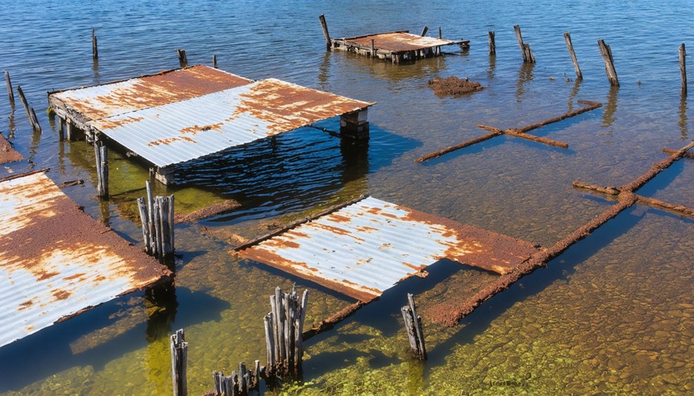
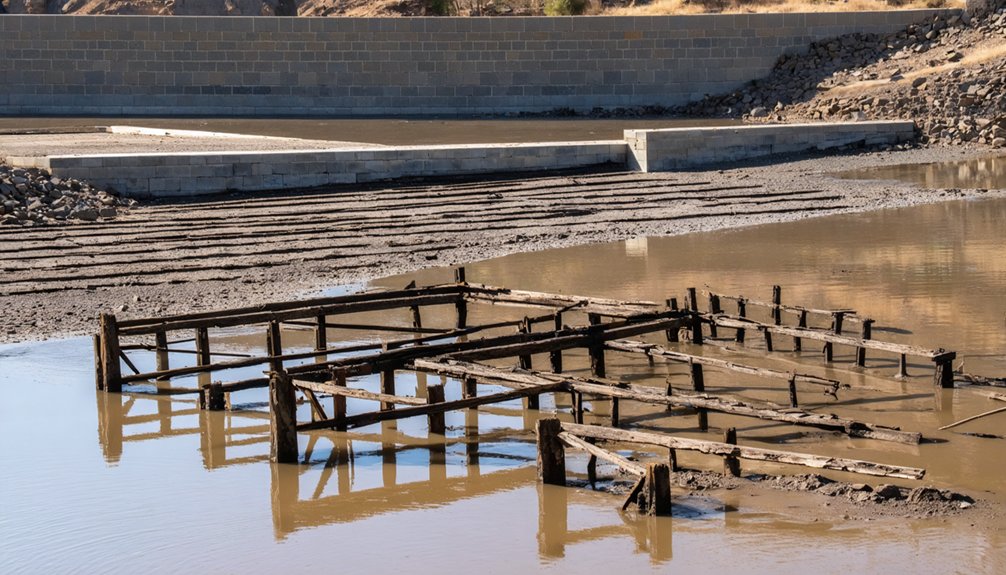
Today, the town’s remnants occasionally resurface when drought conditions reveal foundations and streets during periods of low water levels.
Native American Heritage and Early Settlement
While today’s Lake Berryessa reflects modern California’s water infrastructure, the valley once supported thriving Indigenous communities, particularly the Southern Wintun (Patwin) people who established complex settlements along Putah Creek and its surrounding ridges.
Archaeological surveys in 1976 revealed prehistoric artifacts along the shoreline, providing tangible evidence of ancient habitation.
These Native American communities mastered traditional practices of resource management, using controlled burns to maintain grasslands and oak groves that enhanced food production.
Indigenous wisdom guided careful land stewardship through controlled burns, nurturing grasslands and oak groves for sustainable food systems.
You’ll find evidence of their sophisticated economy in the archaeological record – from obsidian tool manufacturing to shell bead currency networks. Cultural significance ran deep, with at least 24 federally recognized tribes holding ancestral connections to the landscape.
The area later became home to the Basque-heritage Berreyesa family who received Mexican land grants in the region.
Sadly, Spanish missionization, disease epidemics, and 19th-century American expansion devastated these communities through forced relocations, land seizures, and population decline.
Many cultural sites now rest beneath Lake Berryesa’s waters.
From Mexican Land Grant to American Community
The transformation of Berryessa Valley began in 1843 when Governor Manuel Micheltorena granted José de los Reyes Berreyesa and Sexto Berelleza an eight-league tract spanning roughly 36,000 acres. This Mexican land grant, known as Rancho Las Putas, covered the fertile Putah Creek valley and surrounding foothills from Capay Valley toward present-day Vacaville.
After the Mexican-American War, the Treaty of Guadalupe Hidalgo guaranteed land-grant claims, but the 1851 California Land Act required costly legal proceedings. The Berryessa family managed several way stations throughout their extensive property.
You’ll find that the Berryessa family, though land-rich but cash-poor, lost most of their holdings through debt-driven sales and legal pressures. By the 1850s, American settlement transformed the valley as Anglo farmers and developers purchased subdivided parcels, establishing the town of Monticello and converting the land to farms and orchards. Today, the entire valley lies beneath Lake Berryessa’s 20,700 acres of water.
Life Before the Flood
Before the flood transformed Berryessa Valley into a reservoir, you’d find a thriving community of 250-300 residents living in Monticello town, with additional families scattered across surrounding ranches.
The valley’s rich soil supported extensive farming operations across 20,700 acres, while Putah Creek provided essential water for the area’s dominant ranching activities. The land had been continuously farmed since Jose Jesus Berryessa received his original grant in 1843.
Your typical day might include stops at the general store, hotel, or one of the gas pumps, while weekends often featured rodeos and social gatherings that knit the community together. The town saw a gradual decline as federal land claims in the 1950s forced residents to relocate.
Prosperous Valley Community Living
During its heyday in the early 1900s, Berryessa Valley flourished as a close-knit agricultural community, reaching a peak population of 500 residents who cultivated the remarkably fertile soil along Putah Creek.
You’d find a vibrant community dynamics centered around Monticello, where a hotel, restaurant, general store, and two gas pumps served the local population. The agricultural legacy ran deep, with generations of farming families working the prosperous lands and raising livestock.
The valley’s social fabric was woven through regular rodeos, gatherings at the local bars, and strong familial connections between ranchers. Documentary photographer Dorothea Lange captured the valley’s final days in her poignant photo essay “Death of a Valley.”
The area’s self-sufficiency was evident in its infrastructure, including a cemetery and grain silos. Despite not being known for wine production yet, the valley’s rich soil supported extensive farming operations that sustained this thriving rural community.
Farming Families’ Daily Routines
Life in Berryessa Valley revolved around carefully orchestrated daily routines, with farming families rising before dawn to begin their sunrise-to-sunset workdays.
You’d find men in the fields managing crops and livestock, while women tended to household production tasks like gardening, canning, and dairy processing. Children pitched in with age-appropriate chores, from herding cattle to collecting eggs.
Daily labor followed natural seasonal cycles, with intense periods during spring planting and fall harvest. Farmers would spend three days making mule train trips to transport their grain harvests to Napa.
You’d spend mornings checking livestock and maintaining essential tools, afternoons working the fields or orchards, and evenings ensuring proper irrigation from local creeks.
The farm infrastructure demanded constant attention – from repairing wagon wheels to maintaining barns and fences. Tool maintenance became a daily ritual, with major equipment overhauls scheduled during winter’s quieter months.
The Solano Project and Forced Evacuation
In 1948, the Secretary of the Interior authorized the ambitious Solano Project under the Reclamation Project Act of 1939, setting in motion a massive water management initiative that would forever transform California’s Berryessa Valley.
The evacuation impact was profound as families faced forced displacement from their ancestral lands. Despite community resilience, the federal government’s plans proceeded relentlessly through the 1950s.
Key aspects of the project’s implementation included:
- Construction of the 304-foot Monticello Dam completed in 1957
- Creation of Lake Berryessa with 1.6 million acre-feet capacity
- Installation of a morning-glory spillway system
- Displacement of the entire town of Monticello
- Loss of prime agricultural land, including established ranches and orchards
The project dramatically altered the landscape, submerging a thriving farming community beneath 165 miles of shoreline.
Preserving Memories Through Photography
You’ll find some of the most poignant records of Berryessa Valley’s transformation in Dorothea Lange‘s stark black-and-white photographs from her 1956 “Death of a Valley” photo essay.
Through her lens, Lange captured the human toll of displacement as families watched their homes burn and cemetery remains get relocated.
Her photographs preserve haunting views of the vanishing valley, serving as critical documentary evidence that continues to shape public understanding of what was lost beneath Lake Berryessa’s waters.
Lange’s Historical Documentation
Through her groundbreaking photographic series “Death of a Valley,” renowned photographer Dorothea Lange, alongside collaborator Pirkle Jones, documented the final year of Berryessa Valley before its inundation by the Monticello Dam in 1956.
Lange’s impact on historical preservation was profound, as she captured the emotional toll of displacing 250 residents and the destruction of a thriving farming community. Her documentary techniques focused on both intimate human portraits and stark industrial scenes.
- Dramatic black-and-white photography emphasized texture and emotional gravity
- Before-and-after compositions contrasted thriving farmland with desolation
- Personal artifacts and family relics photographed in abandoned homes
- Night shots portrayed the dam’s ominous presence
- Sequential reportage tracked community resistance through final demolition
Vanishing Valley Views
While Lange’s photographic legacy laid the groundwork for documenting Berryessa’s transformation, modern photographers continue to preserve the valley’s evolving story using specialized techniques and methodologies.
To capture the vanishing landscapes of Berryessa, you’ll need to position yourself at prominent overlooks that match historical photo stations. Fine-tune your camera’s position by aligning stable landmarks with archival prints, then use small apertures and focus stacking for maximum depth-of-field.
When documenting the ghostly remnants, you’ll want to employ long exposures of 60 seconds or more at ISO 100 to perfectly capture the structures’ details.
Exploring the best ghost towns in California offers a unique glimpse into the past, where time seems to stand still. Each town tells its own story through its dilapidated buildings and faded signs, making them perfect subjects for photography. Prepare to be captivated by their haunting beauty and the memories they evoke.
Underwater Remains and Drought Revelations
As drought conditions intensify in California, Lake Berryessa’s receding waters have exposed the haunting remains of Monticello, a once-thriving farming community that was deliberately flooded in the 1950s.
With the lake’s surface dropping 63 feet below normal levels to 377 feet above sea level, you’ll find foundations, an old bridge, and other structural remnants emerging from the depths.
These drought impacts have shrunk the reservoir to just one-third of its normal size, revealing more of the town’s submerged history than ever before.
- Water levels dropped lower than the severe 1976-77 drought
- Lake lost 60% of its water volume
- Original cemetery was relocated before flooding
- Government ordered complete demolition of structures
- Dorothea Lange documented the valley’s destruction
Dark Chapter: The Zodiac Killer Connection
Lake Berryessa’s dark history extends beyond its submerged town to include one of California’s most notorious criminal cases.
On September 27, 1969, at 6:30 PM, the Zodiac killer attacked two college students, Bryan Hartnell and Cecelia Shepard, at a secluded picnic spot along Twin Oak Ridge.
On a tranquil fall evening in 1969, the Zodiac brutally ambushed two unsuspecting students enjoying a lakeside picnic.
Wearing his signature executioner-style hood with Zodiac symbolism, the killer bound and repeatedly stabbed both victims. Shepard died from her wounds, while Hartnell survived.
The attack bore hallmarks of the Zodiac’s methodology: victim profiles matched his preference for young couples in isolated areas, and he left his crossed-circle emblem on their car door.
After fleeing toward Knoxville Road, he called police from a Napa payphone to claim responsibility, continuing his pattern of taunting law enforcement.
Frequently Asked Questions
Can Visitors Scuba Dive to Explore the Underwater Ruins of Monticello?
You can legally scuba dive to explore Monticello’s underwater ruins, but you’ll need proper certification, must avoid dam infrastructure, and should watch for hazards like poor visibility and submerged structures.
What Happened to the Original Furniture and Belongings of Monticello Residents?
You won’t find original furniture beneath Lake Berryessa since residents packed, sold, or relocated their belongings. They preserved memories by taking everything before the government’s ordered destruction and burning of structures.
Are There Any Surviving Descendants of the Berryessa Family Today?
Yes, you’ll find Berryessa descendants living today, including Kendall Langan and Anthony Ray, who actively preserve their family legacy through historical research and public speaking at local historical societies.
Does the Lake’s Water Quality Affect Nearby Communities’ Drinking Supply?
Through 24/7 monitoring that tests for over 100 contaminants, you’ll find Lake Berryessa’s water meets EPA standards, protecting community health while serving as an essential drinking supply for nearby residents.
What Wildlife Inhabited the Valley Before It Became Lake Berryessa?
You’d have found remarkable wildlife diversity in the valley, from black-tailed deer and tule elk to mountain lions, otters, beavers, native trout, and diverse bird species in historical ecosystems.
References
- https://www.ghosttowns.com/states/ca/berryessa.html
- https://www.youtube.com/shorts/EWB7k0yLIyY
- https://towntraveller.wordpress.com/2020/06/22/lake-berryessa-california/
- https://www.altaonline.com/dispatches/a5701/lake-berryessa-dorothea-lange/
- https://en.wikipedia.org/wiki/Lake_Berryessa
- https://napavalleyfocus.substack.com/p/the-history-of-napa-valleys-lake
- https://www.sfchronicle.com/bayarea/article/Reservoir-ghost-towns-offer-glimpse-of-history-6677377.php
- https://kids.kiddle.co/Monticello
- https://en.wikipedia.org/wiki/Monticello
- http://www.gribblenation.org/2024/01/the-putah-creek-bridge-of-monticello.html


