You’ll find Iowa’s ghost towns offer exceptional drone photography opportunities, especially in places like Buckhorn Creamery and the abandoned schoolhouses of Dows. These forgotten settlements showcase the state’s rich agricultural heritage through weathered structures and old railroad paths set against sweeping farmland vistas. For the best shots, plan your flights during golden hour when long shadows stretch across crumbling granaries and empty storefronts. The stories these aerial perspectives reveal run deeper than first glance.
Key Takeaways
- Buckhorn Creamery offers stunning aerial views of historic agricultural ruins against Iowa’s pastoral landscape during golden hour.
- Dows’ abandoned schoolhouse provides compelling drone compositions, especially when capturing long shadows during sunrise or sunset.
- Ghost towns near former railroad routes create dramatic visual narratives when photographed with drones during fall foliage season.
- Empty granaries and weathered farm structures provide excellent subjects for HDR drone photography, particularly after storm systems pass.
- Abandoned mill sites with valley fog offer mysterious atmospheric effects ideal for early morning drone photography sessions.
Why Iowa’s Ghost Towns Make Perfect Drone Subjects
While Iowa’s cornfields stretch endlessly toward the horizon today, they’re dotted with remnants of a bygone era that make exceptional subjects for drone photography.
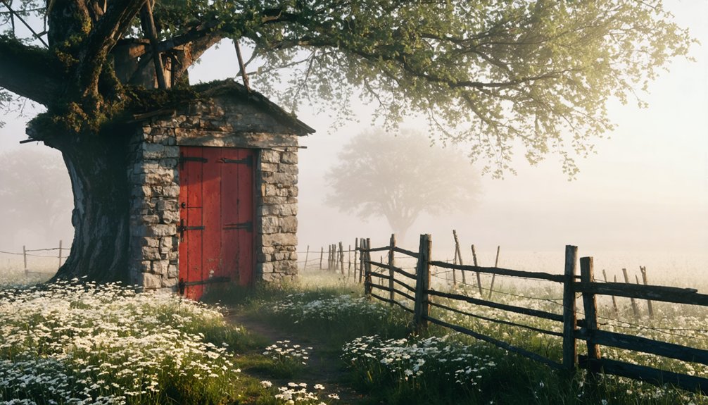
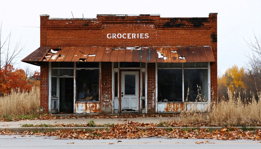
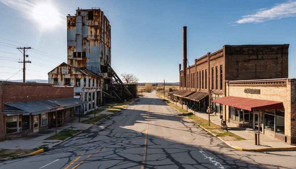
These abandoned settlements offer striking visual contrasts against the agricultural landscape, where church steeples and grain elevators pierce the sky as perfect focal points for aerial storytelling. The historic Buckhorn Creamery, once a major butter producer serving the Midwest, stands as a testament to the region’s agricultural heritage. The old schoolhouse ruins in Dows provide a haunting glimpse into early 20th-century education.
Ghost towns stand sentinel among Iowa’s farmland, their weathered structures punctuating endless fields like memories frozen in time.
You’ll discover how seasonal changes transform these ghost town narratives throughout the year. Tilled fields give way to corn, then harvest stubble, creating ever-changing backdrops for your drone work.
The fog-shrouded river valleys and reservoir shores, where some towns now lie submerged, add mystery to your compositions. From Carrollton to Stiles, each site tells a unique story of railroad relocations and economic shifts, waiting for you to capture their haunting beauty from above.
Essential Drone Photography Equipment for Ghost Town Shoots
Successful ghost town drone photography demands four essential equipment categories that seasoned Midwest aerial photographers have refined through years of documenting abandoned settlements.
You’ll need a drone with at least 20MP or 4K/60fps capability, paired with a 3-axis gimbal for those gusty Iowa prairie conditions. For optimal nighttime shots, consider mounting Lume Cube lights to your drone for dramatic illumination. For drone maintenance in dusty grain elevator shoots, pack lens cleaning kits and landing pads to protect your gear from debris.
Smart battery management is vital when exploring remote locations like abandoned railroad towns. Carry at least four flight batteries and a portable power station for recharging. Having a Part 107 certification is legally required for any commercial ghost town photography ventures.
Don’t forget your permits and landowner contacts – many ghost towns sit on private farmland. Pack neutral density filters for those golden-hour shots of weathered barn wood, and LED lights for illuminating dark interiors of forgotten general stores.
Since the early days of aerial farm surveys, midwest ghost town photographers have learned to work within nature’s tight scheduling windows.
You’ll need to carefully plan around Iowa’s distinct weather patterns, especially during peak thunderstorm season from April through June when tornadoes can threaten both equipment and safety.
The golden hour’s warm light brings out the character in weathered grain elevators and abandoned storefronts, while winter’s low sun angles cast dramatic shadows across forgotten Main Streets. In towns like Grand River where Ghost Town Auto stands abandoned, these lighting conditions create particularly evocative imagery.
You’ll want to watch for valley fog near old mill sites and riverfront ruins, typically clearing by mid-morning.
When shooting in open farmland, those unobstructed prairie winds can challenge your drone’s stability – stay under 20 mph for the steadiest shots.
Remember that cold weather saps battery life, so pack extras during winter documentation flights.
Aerial Photography Tips for Capturing Haunting Perspectives
When photographing abandoned prairie settlements from above, you’ll want to plan your drone’s flight path to capture both sweeping vistas of weathered grain elevators and intimate details of crumbling homesteads.
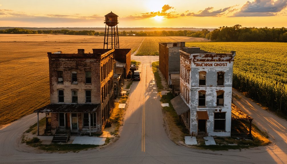
To achieve those haunting perspectives that define Midwest ghost towns, position your drone during golden hour when long shadows stretch across abandoned railroad tracks and deserted Main Streets.
You can enhance the moody atmosphere by following the natural lines of old cattle trails and fence rows, letting them guide viewers through your composition while varying your altitude to reveal the full scope of agricultural abandonment. Using a DJI Mavic Air II provides optimal control and quick deployment for capturing these historic locations before lighting conditions change.
Like the haunting remains of Craco in Basilicata, these abandoned Midwestern towns serve as perfect subjects for documenting the aftermath of natural disasters and economic decline.
Lighting For Moody Shots
Taking haunting aerial photographs of ghost towns demands mastery over nature’s most dramatic lighting conditions.
To capture Iowa’s abandoned farmsteads and rural settlements with atmospheric effects that evoke their history, you’ll want to harness both golden hour and stormy weather. The vast Midwestern skies offer perfect backdrops, especially when storm clouds roll across former agricultural communities. The intense orange-blue contrast during sunset creates an especially dramatic mood over decaying structures. Using a soft diffused light from an overcast sky helps evenly illuminate the architectural details of abandoned buildings.
- Position your drone during sunrise or sunset to cast long shadows across deteriorating grain silos and barns
- Use foggy mornings to create ethereal scenes of abandoned Main Streets
- Shoot during overcast conditions to enhance the moody atmosphere of empty homesteads
- Capture rays of sunlight breaking through clouds above forgotten church steeples
- Frame shots during blue hour when artificial lights still glow in ghost town windows
Flight Path Planning Tips
To capture Iowa’s decaying towns from above, careful flight path planning transforms random aerial shots into compelling historical narratives.
You’ll want to optimize your flight paths by dividing routes into 5-minute segments, especially when covering multi-site tours like Buckhorn to Rockville.
For maximum efficiency and drone safety measures, map clockwise patterns around key structures like Buckhorn’s church ruins and the old creamery.
Keep a 100-foot buffer from unstable buildings in Carrollton, and establish emergency landing zones in the surrounding fields.
When documenting mill remnants in Rockville and Stiles, maintain a 50-foot distance from structures while following the former railroad lines that once connected these bustling farming communities.
Plan your dawn sequences carefully, letting the morning light reveal the haunting beauty of Iowa’s forgotten settlements.
The famed dance hall of Sunbury offers a particularly striking subject for aerial photography, with its historical architecture standing as a testament to the town’s more vibrant past.
Composition From Above
Mastering aerial composition transforms ghost town photography from simple documentation into haunting artistry that captures the spirit of abandoned Midwest settlements.
When framing Iowa’s forgotten farming communities from above, your drone’s unique vantage point reveals stories that ground-level shots miss.
- Position your drone during golden hour to capture long shadows stretching across weathered grain silos and empty Main Streets.
- Layer your shots with abandoned railroad tracks leading to crumbling grain elevators in the distance.
- Frame stark silhouettes of church steeples and water towers against dramatic prairie sunsets.
- Seek overhead angles that showcase how nature is reclaiming old homesteads and field patterns.
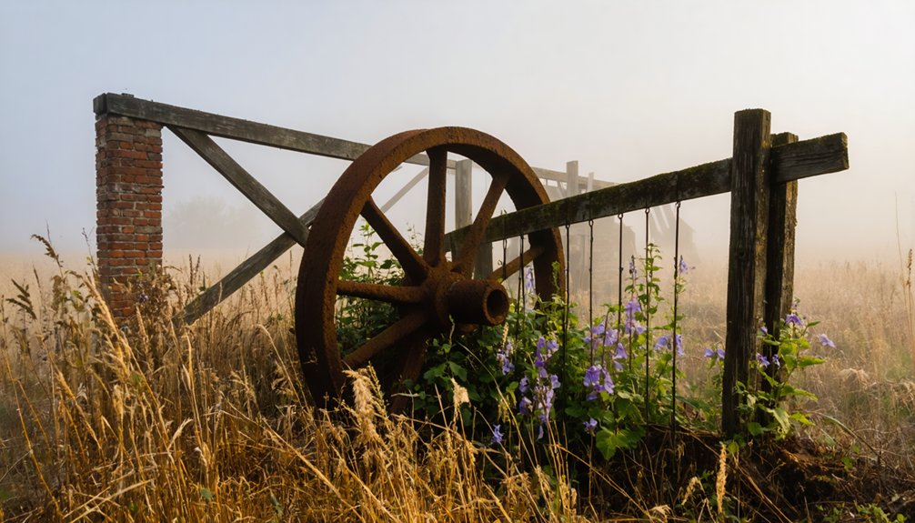
- Use low-altitude flights to highlight textures of rusty farm equipment and collapsed barns.
These aerial composition techniques help preserve the memory of Iowa’s agricultural heritage while creating visually compelling stories of rural decline.
Legal Requirements and Permissions for Ghost Town Drone Flights
Before you lift off to capture Iowa’s abandoned settlements, several critical legal requirements must be navigated to guarantee your drone operations remain compliant with both federal and state regulations.
Properly navigating drone regulations is essential before photographing Iowa’s ghost towns to ensure full compliance with all applicable laws.
You’ll need a remote pilot certificate for commercial photography, and your drone must be registered with the FAA if it weighs over 0.55 pounds.
Iowa’s new farmstead buffer rules are particularly relevant when photographing ghost towns near agricultural areas. You can’t fly within 400 feet of active farmsteads without permission, and surveillance over any homestead is now criminalized.
Even abandoned-looking properties require careful consideration – they’re often still privately owned. Check county records to identify landowners and secure written permission before flying.
Top Angles to Showcase Architectural Decay From Above
When capturing Iowa’s architectural remnants from above, strategic drone angles reveal the poignant story of the state’s forgotten settlements. By positioning your drone thoughtfully, you’ll document decay patterns that showcase how time has transformed these once-thriving communities into haunting historical markers.
- Capture 45-degree oblique shots to highlight exposed beams and structural collapse, as seen in Rockville Mill’s twisted timbers.
- Frame vertical nadir views to document foundation outlines and settlement patterns, like Sunbury’s 1895 dance hall footprint.
- Use circular orbits to reveal how nature reclaims walls and perimeters, evident at Buckhorn Church.
- Employ high-altitude panoramas to contrast architectural features against surrounding farmland.
- Position 30-degree tilts to emphasize the skeletal remains of roofless structures and their relationship to the landscape.
Seasonal Considerations for Ghost Town Drone Photography
You’ll find nature’s seasonal palette transforms abandoned frontier towns into distinct visual stories throughout the year, from fall’s golden prairie grasses framing weathered grain elevators to winter’s stark white drifts against blackened timber frames.
Spring storms rolling across the plains can cast dramatic shadows and god rays through broken rooflines, though you’ll need to carefully time your flights between weather systems.
Summer’s harsh midday light presents challenges, but dawn and dusk hours offer warm, directional illumination that highlights architectural textures and brings out the rich patina of rusty farm equipment and sun-bleached wood.
Fall’s Dramatic Color Palette
During Iowa’s fleeting autumn season, the stark remnants of ghost towns transform into spectacular subjects for drone photography as nature drapes the surrounding landscape in rich maples and oaks.
As night falls, the skies clear, revealing exceptional star patterns that make it one of the best locations for astrophotography in Iowa. Capturing the Milky Way over the plains provides a breathtaking backdrop, while the dark countryside offers a serene atmosphere for photographers. With minimal light pollution in many areas, enthusiasts can experiment with long exposure techniques to bring the cosmos to life.
The interplay between fall foliage and weathered structures creates compelling compositions that tell stories of our pioneering past.
You’ll find the most dramatic color saturation during these prime shooting conditions:
- Mid-October delivers peak colors in northeastern counties, while southwestern regions peak in late October
- River valleys and bluffs showcase color changes 1-2 weeks earlier than surrounding uplands
- Golden hours after sunrise and before sunset maximize contrast and texture
- Clear skies following cold fronts produce the most vivid aerial compositions
- North-facing slopes display deeper reds and purples, while south-facing areas hold their green tones longer
Winter’s Ethereal Abandoned Beauty
Throughout the stark Midwest winter, abandoned ghost towns transform into hauntingly beautiful subjects for drone photography as snow blankets the silent structures and barren fields.
You’ll find winter textures at their peak during golden hour, when low-angle sunlight casts long shadows across snow-filled doorways and collapsed barn roofs, creating dramatic contrasts that weren’t visible in warmer months.
The crisp winter air offers superior visibility for capturing ethereal landscapes, especially during early mornings when mist rises from nearby creek valleys.
Your drone can frame skeletal farmhouses against pristine snow fields, while hoarfrost temporarily adorns rusted machinery and weathered wood.
Just remember to pack extra batteries – winter’s cold reduces flight times, but the haunting beauty of Iowa’s ghost towns in winter makes every shortened flight worthwhile.
Summer Storm Light Effects
While Iowa’s summer storms can pose challenges for drone pilots, these dramatic weather systems create some of the most compelling light conditions for ghost town photography. The interplay between storm clouds and sunlight transforms abandoned Main Streets and weathered farmsteads into haunting masterpieces.
- Post-storm golden hour bathes crumbling grain elevators in rich, warm tones that highlight decades of weathering.
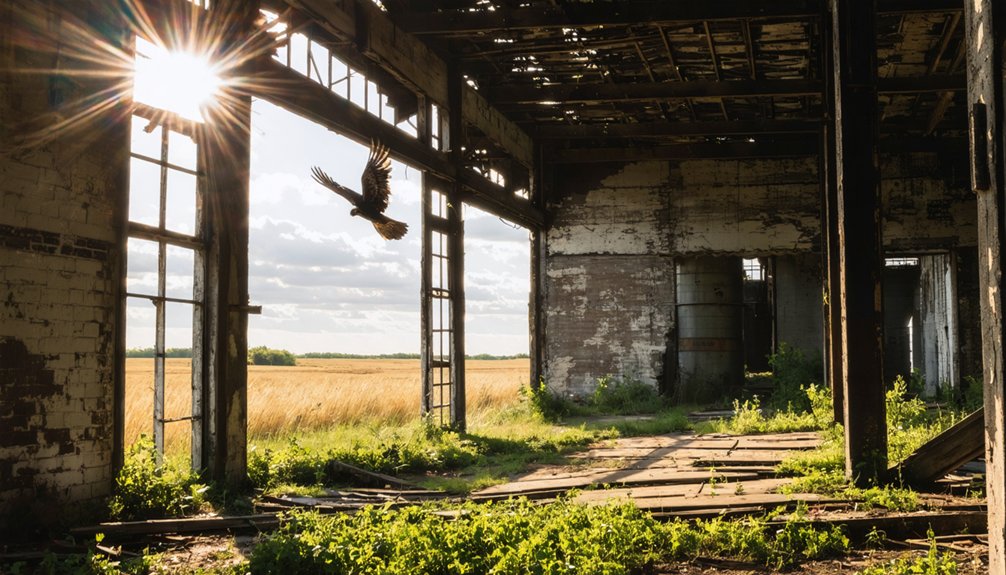
- Storm breaks cast dramatic crepuscular rays through broken windows, creating ethereal beams in abandoned church interiors.
- Diffuse overcast light reveals subtle textures in aged brick and worn wood that harsh sunlight typically obscures.
- Approaching shelf clouds provide ominous backdrops that emphasize the isolation of prairie ghost towns.
- Evening blue hour combined with lingering storm anvils produces moody silhouettes of empty storefronts and silent silos.
Safety Precautions When Flying Over Abandoned Structures
Before you send that drone skyward to capture haunting images of abandoned structures, understanding critical safety protocols can mean the difference between a successful shoot and a costly mishap.
When exploring Iowa’s forgotten farmsteads and rural ruins, you’ll need to follow drone regulations carefully – checking airspace restrictions through B4UFLY and securing landowner permissions where possible.
Inspect your location thoroughly before launch. Those weathered barns and grain elevators that dot our prairie landscape may look picturesque, but they’re often structurally compromised.
Choose stable ground for takeoff, away from hazards like loose tin roofs or rotting timbers. Keep your drone equipped with prop guards and maintain healthy battery reserves.
You’ll want obstacle-sensing capabilities for maneuvering around unstable chimneys and collapsing walls that characterize these historic sites.
Best Times of Day for Dramatic Ghost Town Footage
As golden rays pierce through broken windows and weathered boards, capturing ghost towns demands strategic timing to achieve the most evocative footage. Iowa’s abandoned grain elevators and weathered farmsteads tell powerful stories when captured in the right light.
- Golden hour transforms rusted farm equipment and weather-beaten silos into copper-tinged monuments, especially 30 minutes after sunrise.
- Blue hour casts an ethereal glow over empty Main Streets, perfect for capturing the glow of any remaining vintage neon signs.
- Early mornings offer the calmest conditions for steady drone flight over crumbling limestone foundations.
- Overcast days reveal subtle details in worn clapboard and faded advertisements painted on brick walls.
- Dawn’s first light creates dramatic long shadows across abandoned railroad tracks and empty grain storage yards.
Post-Processing Techniques for Enhancing Eerie Atmospheres
Three essential post-processing techniques can transform ordinary drone footage of Iowa’s abandoned farmsteads into haunting visual stories.
Start by blending multiple exposures to capture both sun-bleached silos and shadowy barn interiors, preserving the rich details of Midwest agricultural decay. You’ll want to master HDR merging to reveal both weathered wood grain and rusted machinery against dramatic prairie skies.
For eerie color grading, desaturate the greens of overgrown fields while keeping warm highlights on broken windows and metal roofs.
Cool blue shadows in empty granaries create depth, while selective sharpening brings out the texture of crumbling limestone foundations and splintered barn boards.
Finally, use graduated filters to darken image edges, drawing focus to haunting architectural elements that tell stories of Iowa’s forgotten farming communities.
Frequently Asked Questions
How Do Local Residents Feel About Drone Photographers Visiting These Sites?
You’ll find mixed reactions – locals want to protect their heritage but can support respectful drone photography when you coordinate ahead. Community concerns include noise and privacy, while tourism impact matters to those seeking preservation.
Are There Any Documented Paranormal Encounters During Ghost Town Drone Flights?
You’re barking up the wrong tree if you’re seeking verified paranormal sightings during drone flights. While following drone regulations, you’ll find no officially documented supernatural encounters in Iowa’s ghost towns.
However, the allure of ghost town filming locations in Iowa often captivates filmmakers and tourists alike. Many are drawn to the rustic charm and eerie atmosphere, making these sites perfect backdrops for spooky cinematic projects. Exploring these abandoned places can offer a glimpse into the past while igniting the imagination.
Which Ghost Towns Have the Most Intact Original Signage?
You’ll find Donnan has the most intact historical signage, with its prominent memorial sign and plaque at the junction crossroads marking significant agricultural heritage and preserving the town’s final 1991 footprint.
How Accessible Are These Locations During Winter Months?
Through snow-dusted fields, you’ll find Buckhorn and Sunbury easily accessible via maintained highways. Winter accessibility remains decent, though you’ll want four-wheel drive. Stiles requires extra safety precautions, while Rockville’s rural paths stay navigable.
Do Any of These Towns Still Have Living Former Residents?
You’ll find former residents and their descendants living on nearby farms around these ghost towns, maintaining cemeteries and sharing local history, though they’ve moved from the original town centers themselves.
References
- https://www.onlyinyourstate.com/experiences/iowa/ia-ghost-town
- https://www.youtube.com/watch?v=YDd_wn2B2js
- https://www.survivingateacherssalary.com/off-the-beaten-path-the-lost-towns-under-lake-red-rock-iowa/
- https://kdat.com/drones-capture-iowa-views-youve-never-seen-before/
- https://www.youtube.com/watch?v=L883pwCPOwE
- https://www.youtube.com/watch?v=1J0Qx64ZrwI
- https://carte-urbex.com/en/blogs/infos/top-10-abandoned-places-in-iowa
- https://freepages.history.rootsweb.com/~gtusa/usa/ia.htm
- https://www.digitalcameraworld.com/features/interview-gary-cummins-uses-drones-to-shoot-derelict-buildings-but-not-in-the-way-you-might-think
- https://www.youtube.com/watch?v=cVS0IgemQw4