You’ll find exceptional drone photography opportunities across Texas’s ghost towns, with Terlingua’s mining ruins offering dramatic desert vistas during golden hour, and Toyah’s abandoned architecture providing striking geometric compositions. East Texas locations like Aldridge showcase nature reclaiming structures, while Shafter’s historic grid system creates compelling linear patterns. For ideal shots, plan your visits during late spring or fall when clearer skies enhance visibility. The secrets of these forgotten places await your aerial exploration.
Key Takeaways
- Terlingua offers stunning desert landscapes and well-preserved mining ruins, perfect for golden hour drone photography with dramatic shadows.
- Shafter’s organized grid system and abandoned structures create compelling geometric patterns and linear compositions from above.
- The East Texas ghost town of Aldridge features nature-reclaimed buildings amidst lush forest, creating atmospheric aerial shots.
- Toyah provides excellent architectural subjects with historic buildings and leading lines that photograph well during sunrise and sunset.
- Pontotoc’s stone ruins offer strong framing opportunities and cast dramatic shadows when photographed from low oblique drone angles.
Essential Drone Photography Gear for Ghost Town Exploration
When venturing into abandoned ghost towns with your drone, selecting the right gear can mean the difference between capturing stunning footage and returning empty-handed. The DJI Mini 4 Pro‘s sub-249g weight and omnidirectional obstacle sensing make it ideal for maneuvering through tight spaces, while its 4K/60fps HDR capability delivers professional-quality footage.
Pack essential drone accessories like polarizing filters to cut harsh sun glare and Lume Cube 2.0 lights for dramatic shadow play in darker areas. You’ll need extra batteries and a power bank for extended shoots in remote locations. For optimal safety and discretion, plan your shoots during pre-dawn hours to minimize attention from nearby residents. The DJI Smart Case serves as an excellent charging solution when exploring locations without power access.
For editing techniques, shoot in RAW format to maximize post-processing flexibility. When light trails appear in your footage, use Photoshop’s Lighten blend mode with black brush masks to clean up your shots.
Consider bringing the DJI Osmo Pocket as a backup for steady ground-level perspectives.
Weather and Lighting Considerations in Texas Ghost Towns
When shooting Texas ghost towns with your drone, you’ll need to master the interplay of desert light and seasonal conditions to capture their haunting beauty. Exploring the best photography spots in Texas can elevate your drone shots even further. From the rugged landscapes of Big Bend to the vibrant sunsets over the Gulf Coast, each location offers unique perspectives and lighting challenges. Be sure to also visit the Hill Country during wildflower season for a breathtaking burst of color in your images. In addition to capturing stunning visuals, you can find inspiration in the rich stories tied to ghost towns in Texas cinema history. Many filmmakers have used these eerie backdrops to evoke themes of isolation and nostalgia, which can add depth to your photography. As you explore these filmic landscapes, consider how their cinematic portrayal influences the mood and composition of your own shots.
You’ll find the most dramatic shots during winter’s extended golden hours in West Texas, while coastal locations require careful planning around humidity and marine haze.
Storm season demands heightened awareness of wind patterns and thermal turbulence, making pre-dawn and dusk your safest windows for stable flight and rich color capture. The Trans-Pecos region experiences intense thunderstorm activity that can quickly develop during late spring months.
Near Marfa, photographing at night gives you rare chances to document the ethereal mystery lights flickering across the desert horizon.
Desert Light Exposure Tips
As the harsh desert sun bathes Texas ghost towns in ever-changing light, mastering exposure techniques becomes essential for capturing their weathered essence through drone photography.
You’ll get your best shots during golden hour, when the warm directional light sculpts textures and creates dramatic shadows across abandoned structures.
To tame the desert light’s extreme contrast, enable your histogram display and use exposure bracketing of 3-5 frames at ±1-2 EV.
Set your base ISO low and adjust shutter speed or ND filters to protect highlights while preserving shadow detail.
For mixed lighting scenarios, shoot RAW to correct color casts in post-processing.
During peak seasons – late spring and fall – you’ll find clearer skies and more consistent conditions, letting you focus on composition rather than fighting atmospheric challenges. The 2004 tornado that struck Toya demonstrates why shooting historic structures should be prioritized before weather events can claim them. The Milky Way provides stunning backdrops when photographing Terlingua’s boot hill cemetery at night.
Storm Season Safety Protocols
Texas ghost towns demand careful consideration of storm patterns and weather extremes that can impact both safety and image quality.
Your storm tracking strategy should include monitoring weather radios and forecasts, especially during peak tornado seasons from May to June and September to November.
For ideal tornado preparedness, ground your drone immediately when winds exceed 20-30 mph, and schedule flights during dawn or dusk to avoid peak turbulence.
In exposed locations like Toyah, where the 2004 tornado left lasting destruction, you’ll need to inspect structures for storm damage before launching.
Keep your equipment protected in shaded storage, particularly in high-heat destinations like Terlingua where temperatures soar past 100°F. Pay special attention to drone battery storage when capturing aerial shots of the Adobe Trading Company building.
When shooting in remote areas, maintain frequent data backups to protect against power surges from lightning strikes.
During drought conditions, Bluon’s normally submerged structures beneath Lake Buchanan become uniquely visible for aerial photography.
Seasonal Color Planning Guide
Throughout the year, ghost town drone photography demands precise seasonal planning to capture the rich palette of textures and colors unique to each abandoned settlement.
Spring’s wildflower blooms paint Terlingua in purples and yellows from March to May, while fall transforms Aldridge’s foliage into golden hues perfect for aerial compositions.
You’ll find ideal shooting conditions during winter’s crisp mornings in West Texas, where drone regulations allow for clear shots of Toyah High School against azure skies. Capturing the rusty abandoned cars scattered throughout town adds a haunting element to the historical narrative.
Summer requires careful timing – avoid the harsh 2-5 PM heat and opt for dawn flights when seasonal accessibility is best.
Plan your shoots around the equinox shifts for extended golden hour coverage, especially in mountain locations like Shafter. For unique industrial elements, capture the pump jacks in surf at Shafter Lake during sunrise.
Consider the UV index and pack ND filters for midday flights during peak summer months.
Legal Guidelines for Drone Operations at Historic Sites
Before launching your drone at a ghost town, you’ll need to secure proper permits, including an FAA Part 107 remote pilot certificate for commercial photography and site-specific authorizations from property owners or managing agencies.
You must adhere to site-specific flight restrictions, including maximum altitude limits of 400 feet AGL, visual line-of-sight requirements, and designated no-fly zones around fragile historic structures.
Private property ghost towns require explicit landowner permission for takeoff and landing zones, while federal or state-owned sites often maintain strict permitting processes and may prohibit drone operations entirely without special exemptions.
Drone Permit Requirements
When planning to capture ghost towns with your drone, you’ll need to navigate a complex web of permits and authorizations that vary by location and purpose.
Start with FAA drone registration if your aircraft exceeds 0.55 pounds, which costs $5 for a three-year period. You’ll also need Remote ID broadcasting capability, either built-in or via module.
For Texas Historic Commission sites, submit authorization requests to the Site Manager with proof of FAA registration and liability insurance.
If you’re flying commercially, you must hold a Part 107 certificate, while hobbyists need to complete the TRUST test.
Remember that photographing individuals or private property without consent violates Texas law.
Keep your flights below 400 feet, maintain visual line-of-sight, and respect wildlife protection regulations that require special permits for wildlife photography.
Site-Specific Flight Restrictions
Flying drones at historic sites requires maneuvering through a complex web of site-specific restrictions designed to protect cultural resources and public safety.
You’ll need to secure written authorization from site managers at Texas Historical Commission properties, with each approval being date-specific and revocable. The drone operation guidelines typically mandate staying below 400 feet, maintaining visual line-of-sight, and avoiding flights over visitors or sensitive areas.
Before launching your drone, you’ll need to prove FAA registration for craft over 0.55 pounds and show proof of insurance.
Site managers can impose additional limitations to protect fragile remains or prevent interference with interpretive programs.
Property Owner Authorization Rules
Legal drone operations at historic sites require maneuvering multiple layers of property authorizations across federal, state, and local jurisdictions.
You’ll need to secure explicit land access permissions before launching your drone at any Texas ghost town site.
For historic locations under Texas Historical Commission management, you must submit authorization forms to the Site Manager.
Don’t forget that Texas Administrative Code §65.152 mandates Land Owner Authorization for wildlife imaging, which often intersects with ghost town photography.
You’re also bound by Texas Government Code Chapter 423‘s restrictions on image capture in areas where privacy expectations exist.
If you’re operating in municipal boundaries, like White Settlement, you’ll need additional clearance beyond standard property rights acknowledgments.
Remember that some locations fall under National Park Service jurisdiction, requiring separate federal permits.
Terlingua: Mining Ruins and Desert Vistas
Nestled near Big Bend National Park’s western entrance, Terlingua’s ghost town ruins offer drone photographers a compelling mix of industrial decay and sweeping desert panoramas.
You’ll discover prime drone composition opportunities among the Chisos Mining Company‘s remnants, where cinnabar extraction shaped the landscape until the 1940s.
The site’s sandstone structures create striking patterns when viewed from above, with thick walls and exposed timber frames providing natural leading lines.
Frame your shots during golden hour, when low-angle light dramatizes the textures of weathered stone and rusted mining equipment against the Chisos Mountains backdrop.
For unique perspectives, capture the abstract geometries of building foundations and mine tailings from a top-down angle, or juxtapose St. Agnes Church ruins against the vast desert expanse – just maintain safe distances from unstable structures.
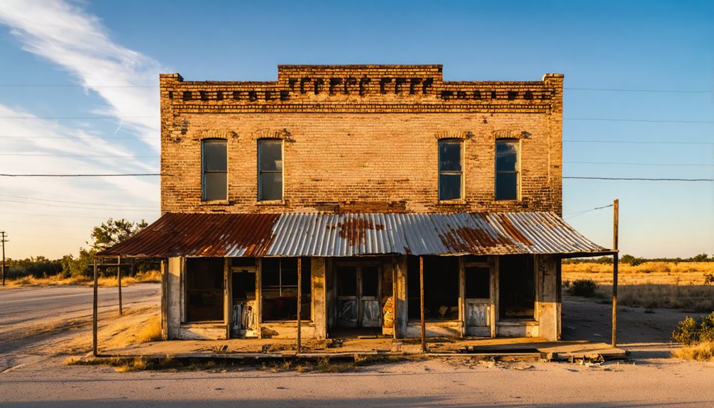
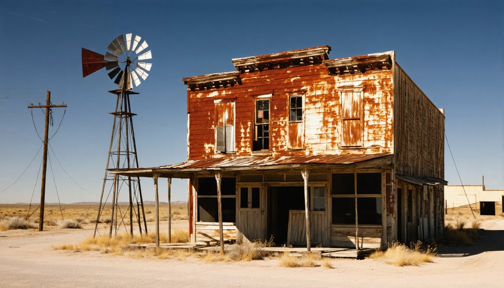
Three architectural treasures anchor Toyah’s ghost town landscape: a 1912 brick schoolhouse, a classical bank building, and the weathered storefronts of old Front Street.
You’ll find prime drone shots by positioning above the schoolhouse’s symmetrical roofline during golden hour, when long shadows amplify its masonry details. The abandoned structures along Front Street create compelling leading lines for low passes, while the bank’s geometric silhouette offers striking top-down compositions.
Before launching, scout the terrain carefully – recent flood damage has left unstable foundations and scattered debris.
Keep your drone well clear of both active railroad tracks and occupied properties. While Toyah’s isolation presents incredible creative freedom, you’ll need to pack emergency supplies and maintain strict drone safety protocols in this remote location just off I-20.
Safety Protocols for Mining District Aerial Coverage
Mining district aerial photography demands rigorous safety protocols before your drone takes flight.
You’ll need to secure your FAA Part 107 certification and obtain specific permits from mine operators. Each site requires a detailed hazard assessment to identify dangerous areas like open pits, unstable slopes, and blasting zones.
You must establish clear exclusion zones and use geofencing to prevent your drone from entering restricted airspace.
When flying near historic mining operations, guarantee your equipment meets intrinsic safety standards, especially in areas with potential explosive dust or gases. Maintain proper standoff distances from abandoned structures and equipment.
Always carry proof of site safety training and insurance.
Remember to coordinate with MSHA for imaging in restricted zones and follow their guidance on camera use near sensitive areas.
East Texas Ghost Towns: Forest and Foliage Techniques
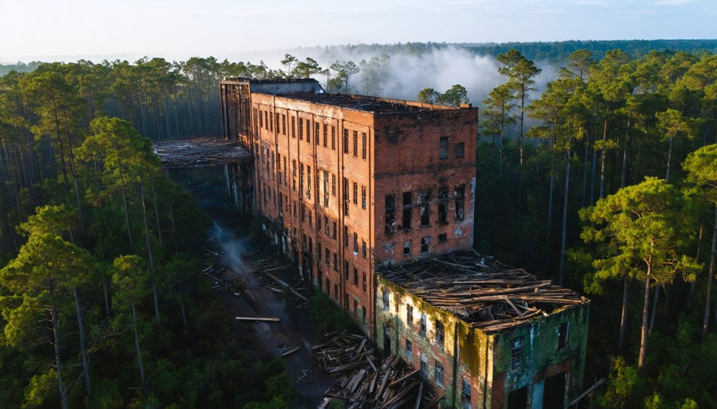
Deep within the dense piney woods of East Texas, abandoned towns like Aldridge and Pontotoc offer drone photographers uniquely atmospheric shots where nature steadily reclaims human structures.
You’ll find dramatic forest photography opportunities at Aldridge’s four massive sawmill ruins, where thick canopy creates compelling aerial contrasts against century-old industrial remains.
For ideal ghost town aesthetics, explore Pontotoc’s typhoid-ravaged cemetery and fire-scarred buildings through natural tunnel-like formations created by overhanging tree limbs.
In Toyah, capture the haunting remnants of its enormous high school and abandoned Front Street, where vegetation slowly engulfs bullet-riddled structures.
Position your drone to frame these forgotten places using the surrounding forest’s natural alleyways, letting the relentless march of foliage tell the story of time’s passage.
Shafter’s Historic Grid: Composition Strategies
You’ll find exceptional drone compositions by following Shafter’s orthogonal grid system, where the 1000-meter UTM lines create striking linear patterns against the high-desert landscape.
The late afternoon sun casts dramatic shadows across abandoned mine structures and stone ruins, turning the historic 1967 survey lines into natural leading elements for your aerial frames.
The remnants of the silver mining era provide perfect architectural anchors, with crumbling walls and shaft openings forming stark geometric shapes that contrast beautifully with the surrounding Presidio County terrain.
Linear Patterns From Above
When viewed from above, Shafter’s historic mining district reveals a mesmerizing grid pattern that’s ideal for drone photography composition.
You’ll discover striking linear perspectives along the 5,000-foot northeastern deposit extension, where replacement mantos in carbonate rocks create natural leading lines for your aerial shots.
The district’s orthogonal street layout offers symmetrical framing opportunities, while the 1,052-foot shaft and surrounding adits add dramatic depth to your aerial grids.
You can align your drone with the UTM Zone 13R’s 1,000-meter intervals for precision shooting, or overlay the 1896 historic patterns with modern grids for compelling time-lapse effects.
For the best results, use USGS GeoPDF formats to plan your flight paths and capture the geometric beauty of this remote mining landscape.
Light and Shadow Play
As morning light creeps across Shafter’s historic grid, dramatic shadows transform the ghost town‘s layout into a mesmerizing interplay of light and dark.
You’ll find the best shadow contrasts during sunrise, when long shadows stretch westward along the remnants of mining-era streets and structures.
For ideal drone shots, position your flight path parallel to the grid during golden hour, when light dynamics are most intense.
The rugged Chinati Mountains provide a stunning backdrop as you capture the town’s geometric patterns from above.
Time your flights to catch afternoon light casting diagonal shadows across stone ruins, or wait for sunset to silhouette the grid against Texas’s crimson sky.
Don’t miss the crepuscular rays piercing through clouds, adding depth to your composition of this 1880s silver mining settlement.
Stone Ruins Frame Shots
The architectural bones of Shafter’s stone ruins offer powerful framing opportunities for drone photographers seeking classical compositions.
You’ll find success by positioning your drone at low oblique angles, 10-25 meters high, where the stone texture reveals itself while capturing complete window and door frames. Align your shots using harmonic armature grids to balance the architectural symmetry of walls and openings.
For the strongest compositions, use the ruins’ natural leading lines – mortar joints, fallen beams, and weathered walls – to draw viewers through stone-framed portals.
Keep your distance at least 1.5 times the opening’s width to avoid distortion. When shooting through windows or doorways, expose for the mid-tones to preserve rich detail in both sunlit stone and shadowed openings.
Coastal Ghost Towns: Managing Maritime Conditions
Maritime environments pose unique challenges for drone photographers exploring coastal ghost towns. You’ll need to carefully monitor tidal impacts that can submerge historic streets and foundations during high water events, potentially altering your planned shots.
Watch for sudden water-level changes that create hazardous currents and debris fields, especially near reservoir-submerged towns that resurface during droughts.
Your equipment faces constant assault from salt exposure, so protect your gear with thorough post-flight cleaning and preventative maintenance. Use elevated launch pads to avoid sand contamination, and keep spare batteries in sealed, desiccated containers.
Coastal hazards include unpredictable wind patterns, with sea breezes and thermal effects creating turbulent conditions near shorelines. Plan your flights during calmer periods and maintain higher safety margins when maneuvering through ruins exposed to maritime conditions.
Best Times and Seasons for Ghost Town Aerial Photography
Spring mornings and fall afternoons emerge as prime windows for capturing ghost town aerials in West Texas, where golden hour lighting bathes abandoned structures in dramatic shadows and textures.
Capture the haunting beauty of West Texas ghost towns when spring sunrise and autumn light paint their weathered remains.
You’ll find these ghost town seasons offer superior drone flight timing, with pleasant temperatures extending your battery life and reducing equipment stress.
For the best results, plan your flights during early morning or late afternoon golden hours, when the sun sits low on the horizon. This timing reveals the stark beauty of sites like Shafter’s Sacred Heart Church while avoiding harsh midday conditions.
Skip summer’s intense heat and crowds, and leverage winter’s clear skies and minimal foliage. You’ll capture crisper footage when thermal updrafts are minimal, and you’ll meet FAA visual line-of-sight requirements more easily in these ideal conditions.
Frequently Asked Questions
How Do Local Residents Typically React to Drone Photography in Ghost Towns?
You’ll find mixed local attitudes, with property owners often opposing unauthorized flights as privacy invasions. They’ll demand permits and may call authorities, though some welcome drone photography if you’ve obtained proper clearance and follow regulations.
Are There Any Paranormal Investigation Groups That Use Drones in These Locations?
Like shadows in moonlight, you’ll find several Texas groups wielding drones for ghost-town investigations, including Texas Ghost Hunters Association, Gulf Coast Paranormal, North Texas Paranormal, and Lone Star Paranormal Society.
Which Ghost Towns Have the Most Intact Original Signage for Aerial Shots?
You’ll find Shafter’s best-preserved signage on the Brooks Memorial building and cemetery markers, while Lobo’s railroad depot signs remain visible – both offering compelling aerial photography angles for drone captures.
Can You Camp Overnight at These Locations for Dawn/Dusk Drone Shots?
Don’t risk trespassing tickets while chasing that perfect ghost town sunrise! You’ll need proper camping regulations and photography permits. Only Terlingua officially allows overnight stays through its lodging options.
Are There Guided Drone Photography Tours Available for Texas Ghost Towns?
You’ll find limited formal guided tours, but local photographers offer ad-hoc workshops where they’ll help with drone regulations and photography permits while teaching you ghost town aerial techniques in select locations.
References
- https://www.youtube.com/watch?v=2lpZOI62WOw
- https://www.youtube.com/watch?v=-aKzLcERnQA
- https://www.jasonrweingart.com/blog/2016/10/4/ten-most-terrifying-abandoned-places-in-texas
- https://www.tripadvisor.com/Attractions-g28964-Activities-c47-t14-Texas.html
- https://www.youtube.com/watch?v=Zd8-gKw-5Hc
- https://www.youtube.com/watch?v=MMmDa0Gm3sI
- https://www.youtube.com/watch?v=Br6kfKqv0bw
- https://www.texasescapes.com/TexasPhotography/Texas-Ghost-Towns-by-Night-Nocturnal-Photography-Noel-Kerns.htm
- https://www.youtube.com/watch?v=P5raE760IZo
- https://www.youtube.com/watch?v=1Vd4pkusiwc


